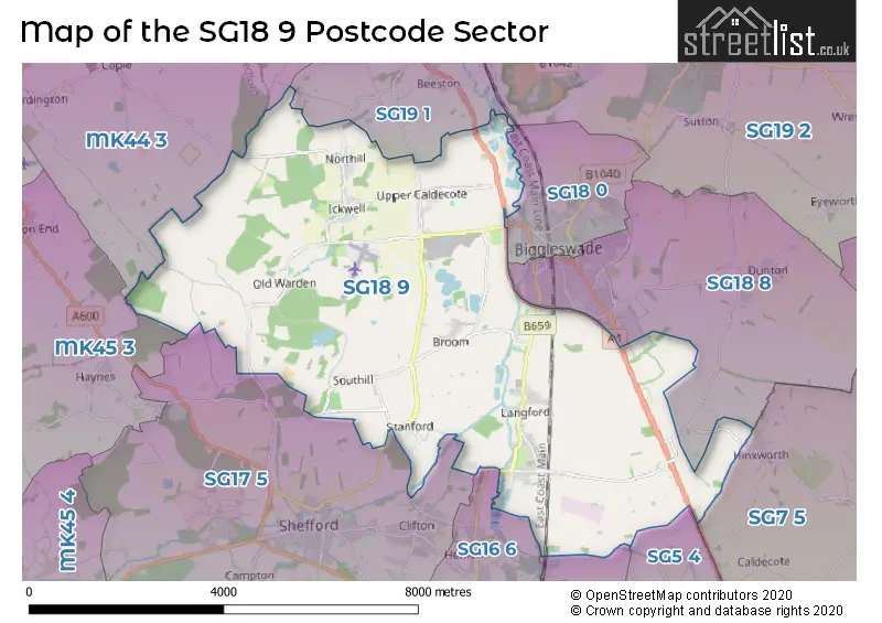
The SG18 9 postcode sector stands on the Bedfordshire and Hertfordshire border.
Did you know? According to the 2021 Census, the SG18 9 postcode sector is home to a bustling 7,504 residents!
Given that each sector allows for 400 unique postcode combinations. Letters C, I, K, M, O and V are not allowed in the last two letters of a postcode. With 240 postcodes already in use, this leaves 160 units available.
The largest settlement in the SG18 9 postal code is Langford followed by Upper Caldecote, and Broom.
The SG18 9 Postcode shares a border with MK44 3 (Great Barford, Blunham, Cople), MK45 3 (Houghton Conquest, Wilstead, Haynes), SG15 6 (ARLESEY), SG16 6 (HENLOW, Lower Stondon, Upper Stondon), SG17 5 (SHEFFORD, Clifton, Meppershall), SG18 0 (BIGGLESWADE), SG18 8 (BIGGLESWADE, Dunton, Stratton Business Park), SG19 1 (SANDY, Beeston, Hatch), SG5 4 (Stotfold, Fairfield) and SG7 5 (Ashwell, BALDOCK, Hinxworth).
The sector is within the post town of BIGGLESWADE.
SG18 9 is a postcode sector within the SG18 postcode district which is within the SG Stevenage postcode area.
The Royal Mail delivery office for the SG18 9 postal sector is the Biggleswade Delivery Office and Langford Scale Payment Delivery Office.
The area of the SG18 9 postcode sector is 22.10 square miles which is 57.24 square kilometres or 14,145.23 square acres.
The SG18 9 postcode sector is crossed by the A1 Major A road.
Waterways within the SG18 9 postcode sector include the River Ivel.

Map of the SG18 9 Postcode Sector
Explore the SG18 9 postcode sector by using our free interactive map.
| S | G | 1 | 8 | - | 9 | X | X |
| S | G | 1 | 8 | Space | 9 | Letter | Letter |
Official List of Streets
Langford (61 Streets)
Upper Caldecote (28 Streets)
Broom (9 Streets)
Northill (11 Streets)
Old Warden (10 Streets)
Stanford (6 Streets)
Ickwell (5 Streets)
Southill (5 Streets)
Lower Caldecote (2 Streets)
BIGGLESWADE (7 Streets)
Unofficial Streets or Alternative Spellings
BIGGLESWADE
BELLS BROOK HITCHIN STREETStratton Business Park
LANCASTER WAY BIGGLESWADE BYPASS BIGGLESWADE NORTH ROUNDABOUT BIGGLESWADE SOUTH ROUNDABOUT BUDNA ROAD CLIFTON ROAD COW CLOSE FISHPOND PATH GRANGE LANE ICKWELL GREEN KINGFISHER WAY MARKET GARDEN ROAD RICHARDS CRESCENT SHEEP WALK STANDFORD ROAD TERRACE WATER LANECople
NORTHILL ROADHENLOW
LANGFORD ROADClifton
STANFORD LANECardington
SOUTHILL ROADWeather Forecast for SG18 9
Press Button to Show Forecast for Swiss Garden
| Time Period | Icon | Description | Temperature | Rain Probability | Wind |
|---|---|---|---|---|---|
| 12:00 to 15:00 | Cloudy | 9.0°C (feels like 7.0°C) | 50.00% | WNW 9 mph | |
| 15:00 to 18:00 | Cloudy | 8.0°C (feels like 6.0°C) | 46.00% | N 9 mph | |
| 18:00 to 21:00 | Cloudy | 7.0°C (feels like 5.0°C) | 7.00% | NE 7 mph | |
| 21:00 to 00:00 | Partly cloudy (night) | 4.0°C (feels like 3.0°C) | 1.00% | ENE 4 mph |
Press Button to Show Forecast for Swiss Garden
| Time Period | Icon | Description | Temperature | Rain Probability | Wind |
|---|---|---|---|---|---|
| 00:00 to 03:00 | Clear night | 3.0°C (feels like 1.0°C) | 1.00% | ENE 4 mph | |
| 03:00 to 06:00 | Clear night | 1.0°C (feels like -1.0°C) | 1.00% | NE 4 mph | |
| 06:00 to 09:00 | Sunny day | 2.0°C (feels like 0.0°C) | 1.00% | NNE 4 mph | |
| 09:00 to 12:00 | Sunny day | 7.0°C (feels like 5.0°C) | 1.00% | ENE 7 mph | |
| 12:00 to 15:00 | Cloudy | 10.0°C (feels like 9.0°C) | 7.00% | NE 4 mph | |
| 15:00 to 18:00 | Overcast | 11.0°C (feels like 10.0°C) | 12.00% | NE 4 mph | |
| 18:00 to 21:00 | Cloudy | 9.0°C (feels like 7.0°C) | 10.00% | ENE 7 mph | |
| 21:00 to 00:00 | Cloudy | 5.0°C (feels like 4.0°C) | 10.00% | ENE 4 mph |
Press Button to Show Forecast for Swiss Garden
| Time Period | Icon | Description | Temperature | Rain Probability | Wind |
|---|---|---|---|---|---|
| 00:00 to 03:00 | Cloudy | 4.0°C (feels like 2.0°C) | 11.00% | ENE 4 mph | |
| 03:00 to 06:00 | Cloudy | 3.0°C (feels like 1.0°C) | 14.00% | ENE 7 mph | |
| 06:00 to 09:00 | Cloudy | 4.0°C (feels like 2.0°C) | 19.00% | NE 7 mph | |
| 09:00 to 12:00 | Cloudy | 9.0°C (feels like 6.0°C) | 22.00% | ENE 9 mph | |
| 12:00 to 15:00 | Cloudy | 11.0°C (feels like 9.0°C) | 18.00% | E 9 mph | |
| 15:00 to 18:00 | Cloudy | 12.0°C (feels like 10.0°C) | 21.00% | ENE 11 mph | |
| 18:00 to 21:00 | Cloudy | 11.0°C (feels like 8.0°C) | 20.00% | ENE 9 mph | |
| 21:00 to 00:00 | Light rain | 8.0°C (feels like 5.0°C) | 54.00% | NE 11 mph |
Press Button to Show Forecast for Swiss Garden
| Time Period | Icon | Description | Temperature | Rain Probability | Wind |
|---|---|---|---|---|---|
| 00:00 to 03:00 | Heavy rain | 8.0°C (feels like 5.0°C) | 73.00% | NE 11 mph | |
| 03:00 to 06:00 | Heavy rain | 8.0°C (feels like 6.0°C) | 77.00% | ENE 9 mph | |
| 06:00 to 09:00 | Light rain shower (day) | 9.0°C (feels like 7.0°C) | 43.00% | SE 9 mph | |
| 09:00 to 12:00 | Light rain | 10.0°C (feels like 8.0°C) | 53.00% | ESE 9 mph | |
| 12:00 to 15:00 | Light rain shower (day) | 11.0°C (feels like 9.0°C) | 45.00% | SE 11 mph | |
| 15:00 to 18:00 | Light rain shower (day) | 13.0°C (feels like 11.0°C) | 38.00% | S 11 mph | |
| 18:00 to 21:00 | Light rain shower (day) | 11.0°C (feels like 9.0°C) | 34.00% | WSW 11 mph | |
| 21:00 to 00:00 | Cloudy | 9.0°C (feels like 7.0°C) | 9.00% | WSW 7 mph |
Schools and Places of Education Within the SG18 9 Postcode Sector
Caldecote Church of England Academy
Academy sponsor led
Manor Place, Biggleswade, Bedfordshire, SG18 9DA
Head: Mrs Sarah Campbell
Ofsted Rating: Requires improvement
Inspection: 2021-11-25 (882 days ago)
Website: Visit Caldecote Church of England Academy Website
Phone: 01767316206
Number of Pupils: 52
Langford Village Academy
Academy sponsor led
Church Street, Biggleswade, Bedfordshire, SG18 9QA
Head: Mrs Debbie Randall
Ofsted Rating: Good
Inspection: 2022-11-23 (519 days ago)
Website: Visit Langford Village Academy Website
Phone: 01462629000
Number of Pupils: 261
Southill Lower School
Community school
School Lane, Biggleswade, Bedfordshire, SG18 9JA
Head: Mrs Samantha Barlow
Ofsted Rating: Good
Inspection: 2021-07-01 (1029 days ago)
Website: Visit Southill Lower School Website
Phone: 01462813312
Number of Pupils: 62
House Prices in the SG18 9 Postcode Sector
| Type of Property | 2018 Average | 2018 Sales | 2017 Average | 2017 Sales | 2016 Average | 2016 Sales | 2015 Average | 2015 Sales |
|---|---|---|---|---|---|---|---|---|
| Detached | £565,401 | 79 | £508,399 | 55 | £452,654 | 42 | £409,426 | 35 |
| Semi-Detached | £326,007 | 55 | £335,717 | 32 | £281,236 | 29 | £255,058 | 25 |
| Terraced | £258,670 | 23 | £302,278 | 18 | £252,638 | 25 | £245,680 | 22 |
| Flats | £233,125 | 4 | £208,000 | 4 | £174,125 | 8 | £153,429 | 7 |
Important Postcodes SG18 9 in the Postcode Sector
SG18 9AH is the postcode for Northill VA Lower School, Bedford Road
SG18 9DA is the postcode for Caldecote Church Of England Academy, Manor Place
SG18 9DX is the postcode for learning resource centre and Classrooms, Shuttleworth College, Shuttleworth Business Centre, Old Warden Park, BLOCKS 1,2 3 & 4, Shuttleworth College, Shuttleworth Business Centre, Old Warden Park, Courtyard 1, Shuttleworth College, Old Warden Park, Clayton and Edmonds, Shuttleworth College, Shuttleworth Business Centre, Old Warden Park, Zoological Education Centre, Shuttleworth College, Old Warden Park, Redbrick Barn, Shuttleworth College, Old Warden Park, Russell Complex, Shuttleworth College, Old Warden Park, Patworth, ongley, milner, Shuttleworth College, Shuttleworth Business Centre, Old Warden Park, BLOCKS 15, 16, 17 & 18, Shuttleworth College, Shuttleworth Business Centre, Old Warden Park, BLOCK 32, Shuttleworth College, Shuttleworth Business Centre, Old Warden Park, Park house, Shuttleworth College, Old Warden Park, Courtyard 2, Shuttleworth College, Old Warden Park, Mechanisation Centre, Shuttleworth College, Old Warden Park, and BLOCKS 8, 9, 10 & 11, Shuttleworth College, Shuttleworth Business Centre, Old Warden Park
SG18 9QA is the postcode for Langford Village Academy, Church Street
| The SG18 9 Sector is within these Local Authorities |
|
|---|---|
| The SG18 9 Sector is within these Counties |
|
| The SG18 9 Sector is within these Water Company Areas |
|