The SG19 1 postcode sector is within the county of Bedfordshire.
Did you know? According to the 2021 Census, the SG19 1 postcode sector is home to a bustling 10,118 residents!
Given that each sector allows for 400 unique postcode combinations. Letters C, I, K, M, O and V are not allowed in the last two letters of a postcode. With 229 postcodes already in use, this leaves 171 units available.
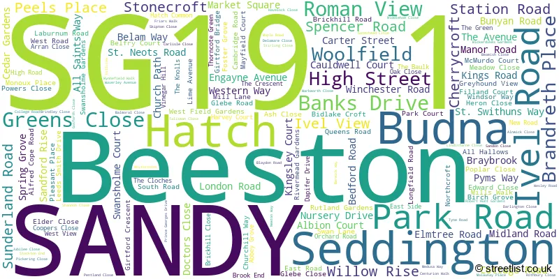
The largest settlement in the SG19 1 postal code is SANDY followed by Beeston, and Hatch.
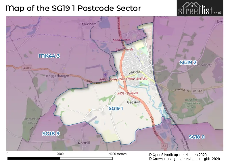
The SG19 1 Postcode shares a border with MK44 3 (Great Barford, Blunham, Cople), SG18 0 (BIGGLESWADE), SG18 9 (Langford, Upper Caldecote, Broom) and SG19 2 (Potton, SANDY, Wrestlingworth).
The sector is within the post town of SANDY.
SG19 1 is a postcode sector within the SG19 postcode district which is within the SG Stevenage postcode area.
The Royal Mail delivery office for the SG19 1 postal sector is the Sandy Delivery Office.
The area of the SG19 1 postcode sector is 3.72 square miles which is 9.65 square kilometres or 2,383.37 square acres.
The SG19 1 postcode sector is crossed by the A1 Major A road.
Waterways within the SG19 1 postcode sector include the River Ivel.

Map of the SG19 1 Postcode Sector
Explore the SG19 1 postcode sector by using our free interactive map.
| S | G | 1 | 9 | - | 1 | X | X |
| S | G | 1 | 9 | Space | 1 | Letter | Letter |
Official List of Streets
SANDY (134 Streets)
Beeston (15 Streets)
Unofficial Streets or Alternative Spellings
Potton
POTTON ROADSANDY
GEORGETOWN ROAD MERLIN DRIVE BUDNA ROAD DELIVERY FAYNES COURT GRANGE GARDENS HILL VIEW KINGFISHER WAY MOORES COURT ONGLEY COURT PARK MEWS RECTORY COURT ROWAN COURT SANDY ROUNDABOUT WAVERLY AVENUENorthill
THORNCOTE ROADBlunham
TEMPSFORD ROADLower Caldecote
GREAT NORTH ROADMoggerhanger
BEDFORD ROADWeather Forecast for SG19 1
Press Button to Show Forecast for Sandy
| Time Period | Icon | Description | Temperature | Rain Probability | Wind |
|---|---|---|---|---|---|
| 15:00 to 18:00 | Cloudy | 12.0°C (feels like 10.0°C) | 6.00% | W 13 mph | |
| 18:00 to 21:00 | Light rain | 9.0°C (feels like 7.0°C) | 54.00% | WSW 11 mph | |
| 21:00 to 00:00 | Light rain | 9.0°C (feels like 6.0°C) | 60.00% | WSW 13 mph |
Press Button to Show Forecast for Sandy
| Time Period | Icon | Description | Temperature | Rain Probability | Wind |
|---|---|---|---|---|---|
| 00:00 to 03:00 | Overcast | 9.0°C (feels like 6.0°C) | 13.00% | W 13 mph | |
| 03:00 to 06:00 | Overcast | 9.0°C (feels like 7.0°C) | 17.00% | WNW 13 mph | |
| 06:00 to 09:00 | Cloudy | 9.0°C (feels like 6.0°C) | 10.00% | WNW 13 mph | |
| 09:00 to 12:00 | Cloudy | 11.0°C (feels like 8.0°C) | 12.00% | NW 16 mph | |
| 12:00 to 15:00 | Light rain shower (day) | 11.0°C (feels like 8.0°C) | 38.00% | NW 16 mph | |
| 15:00 to 18:00 | Cloudy | 11.0°C (feels like 8.0°C) | 29.00% | NNW 13 mph | |
| 18:00 to 21:00 | Cloudy | 9.0°C (feels like 7.0°C) | 10.00% | NNE 9 mph | |
| 21:00 to 00:00 | Clear night | 6.0°C (feels like 4.0°C) | 3.00% | N 9 mph |
Press Button to Show Forecast for Sandy
| Time Period | Icon | Description | Temperature | Rain Probability | Wind |
|---|---|---|---|---|---|
| 00:00 to 03:00 | Clear night | 5.0°C (feels like 2.0°C) | 1.00% | NNW 9 mph | |
| 03:00 to 06:00 | Cloudy | 4.0°C (feels like 1.0°C) | 4.00% | NNW 9 mph | |
| 06:00 to 09:00 | Cloudy | 4.0°C (feels like 1.0°C) | 8.00% | NNW 9 mph | |
| 09:00 to 12:00 | Overcast | 7.0°C (feels like 4.0°C) | 8.00% | N 13 mph | |
| 12:00 to 15:00 | Overcast | 9.0°C (feels like 7.0°C) | 9.00% | N 11 mph | |
| 15:00 to 18:00 | Overcast | 10.0°C (feels like 8.0°C) | 9.00% | N 11 mph | |
| 18:00 to 21:00 | Overcast | 9.0°C (feels like 7.0°C) | 8.00% | NNE 9 mph | |
| 21:00 to 00:00 | Partly cloudy (night) | 6.0°C (feels like 4.0°C) | 2.00% | NNE 4 mph |
Press Button to Show Forecast for Sandy
| Time Period | Icon | Description | Temperature | Rain Probability | Wind |
|---|---|---|---|---|---|
| 00:00 to 03:00 | Cloudy | 5.0°C (feels like 3.0°C) | 4.00% | N 4 mph | |
| 03:00 to 06:00 | Cloudy | 5.0°C (feels like 3.0°C) | 4.00% | NW 4 mph | |
| 06:00 to 09:00 | Cloudy | 5.0°C (feels like 3.0°C) | 6.00% | N 4 mph | |
| 09:00 to 12:00 | Overcast | 8.0°C (feels like 6.0°C) | 11.00% | N 9 mph | |
| 12:00 to 15:00 | Overcast | 10.0°C (feels like 7.0°C) | 13.00% | NNE 11 mph | |
| 15:00 to 18:00 | Cloudy | 10.0°C (feels like 8.0°C) | 11.00% | NNE 11 mph | |
| 18:00 to 21:00 | Partly cloudy (day) | 9.0°C (feels like 6.0°C) | 4.00% | NE 11 mph | |
| 21:00 to 00:00 | Clear night | 6.0°C (feels like 4.0°C) | 4.00% | NE 7 mph |
Press Button to Show Forecast for Sandy
| Time Period | Icon | Description | Temperature | Rain Probability | Wind |
|---|---|---|---|---|---|
| 00:00 to 03:00 | Partly cloudy (night) | 5.0°C (feels like 3.0°C) | 4.00% | NNE 7 mph | |
| 03:00 to 06:00 | Partly cloudy (night) | 5.0°C (feels like 2.0°C) | 3.00% | N 7 mph | |
| 06:00 to 09:00 | Cloudy | 5.0°C (feels like 3.0°C) | 6.00% | N 7 mph | |
| 09:00 to 12:00 | Cloudy | 9.0°C (feels like 6.0°C) | 8.00% | NE 9 mph | |
| 12:00 to 15:00 | Cloudy | 10.0°C (feels like 8.0°C) | 11.00% | NE 11 mph | |
| 15:00 to 18:00 | Cloudy | 10.0°C (feels like 8.0°C) | 11.00% | NE 11 mph | |
| 18:00 to 21:00 | Cloudy | 9.0°C (feels like 7.0°C) | 8.00% | NNE 9 mph | |
| 21:00 to 00:00 | Partly cloudy (night) | 6.0°C (feels like 4.0°C) | 4.00% | NNE 7 mph |
Schools and Places of Education Within the SG19 1 Postcode Sector
Robert Peel Primary School
Foundation school
Dapifer Drive, Sandy, Bedfordshire, SG19 1QJ
Head: Miss Liesl Ganney
Ofsted Rating: Good
Inspection: 2020-03-12 (1498 days ago)
Website: Visit Robert Peel Primary School Website
Phone: 01767681185
Number of Pupils: 391
Sandy Secondary School
Foundation school
Engayne Avenue, Sandy, Bedfordshire, SG19 1BL
Head: Miss Karen Hayward
Ofsted Rating: Requires improvement
Inspection: 2023-01-26 (448 days ago)
Website: Visit Sandy Secondary School Website
Phone: 01767680598
Number of Pupils: 1155
St Swithun's Church of England VC Primary School
Voluntary controlled school
Ivel Road, Sandy, Bedfordshire, SG19 1AX
Head: Mrs Anita Whitehurst
Ofsted Rating: Good
Inspection: 2022-12-08 (497 days ago)
Website: Visit St Swithun's Church of England VC Primary School Website
Phone: 01767680692
Number of Pupils: 224
House Prices in the SG19 1 Postcode Sector
| Type of Property | 2018 Average | 2018 Sales | 2017 Average | 2017 Sales | 2016 Average | 2016 Sales | 2015 Average | 2015 Sales |
|---|---|---|---|---|---|---|---|---|
| Detached | £437,128 | 29 | £387,066 | 28 | £378,086 | 32 | £313,957 | 42 |
| Semi-Detached | £276,142 | 51 | £267,497 | 58 | £247,095 | 38 | £231,264 | 76 |
| Terraced | £213,784 | 49 | £224,478 | 68 | £197,481 | 75 | £184,359 | 94 |
| Flats | £139,286 | 11 | £161,931 | 8 | £143,568 | 14 | £122,738 | 12 |
Important Postcodes SG19 1 in the Postcode Sector
SG19 1BA is the postcode for St. Swithins School, Ivel Road
SG19 1BL is the postcode for Sandy Secondary School, Engayne Avenue, and Sandy Upper School & Community College, Engayne Avenue
SG19 1EH is the postcode for Central Bedfordshire Council, Sandy Library, Market Square
SG19 1HQ is the postcode for Main Block, Laburnum Lower School, Laburnum Road
SG19 1JD is the postcode for BLOCK 2, Sandye Place Academy, Park Road, BLOCK 3, Sandye Place Academy, Park Road, and BLOCK 1, Sandye Place Academy, Park Road
SG19 1JQ is the postcode for SANDY HEALTH CENTRE, NORTHCROFT, SANDY, and Sandy Health Centre, Northcroft
SG19 1NE is the postcode for Allison House, Swan Lane, and ALLISON HOUSE, SWAN LANE, SANDY
SG19 1QJ is the postcode for Robert Peel Lower School, Dapifer Drive
| The SG19 1 Sector is within these Local Authorities |
|
|---|---|
| The SG19 1 Sector is within these Counties |
|
| The SG19 1 Sector is within these Water Company Areas |
|