The SG9 0 postcode sector stands on the Hertfordshire and Essex border.
Did you know? According to the 2021 Census, the SG9 0 postcode sector is home to a bustling 3,281 residents!
Given that each sector allows for 400 unique postcode combinations. Letters C, I, K, M, O and V are not allowed in the last two letters of a postcode. With 225 postcodes already in use, this leaves 175 units available.
The largest settlement in the SG9 0 postal code is Sandon followed by Furneux Pelham, and Rushden.
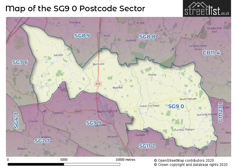
The SG9 0 Postcode shares a border with SG2 7 (STEVENAGE, Walkern, Benington), SG8 9 (ROYSTON, Therfield, Kelshall), SG9 9 (BUNTINGFORD, Cottered, Westmill), SG11 2 (Little Hadham, Braughing, Albury), CM23 1 (BISHOP'S STORTFORD, Manuden, Farnham), SG7 6 (BALDOCK, Clothall, Wallington), SG8 8 (Barkway, Barley, Chrishall) and CB11 4 (SAFFRON WALDEN, Clavering, Wendens Ambo).
The sector is within the post town of BUNTINGFORD.
SG9 0 is a postcode sector within the SG9 postcode district which is within the SG Stevenage postcode area.
The Royal Mail delivery office for the SG9 0 postal sector is the Ware Delivery Office and Buntingford Scale Payment Delivery Office.
The area of the SG9 0 postcode sector is 33.05 square miles which is 85.60 square kilometres or 21,153.04 square acres.

Map of the SG9 0 Postcode Sector
Explore the SG9 0 postcode sector by using our free interactive map.
| S | G | 9 | - | 0 | X | X |
| S | G | 9 | Space | 0 | Letter | Letter |
Official List of Streets
Furneux Pelham (13 Streets)
Great Hormead (6 Streets)
Anstey (8 Streets)
Brent Pelham (3 Streets)
Buckland (5 Streets)
Wyddial (3 Streets)
Stocking Pelham (4 Streets)
Rushden (7 Streets)
Sandon (8 Streets)
BUNTINGFORD (2 Streets)
Hare Street (3 Streets)
Chipping (2 Streets)
Unofficial Streets or Alternative Spellings
Clavering
PELHAM ROAD BACK LANE BECKFIELD LANE BENNETTS LANE BIGGIN BRIDGE BIGGIN HILL BROOKSIDE BROWNEYMEAD LANE BUNTINGFORD BYPASS CAKEBREADS LANE CHAPEL GREEN CHIPPING BRIDGE CONDUIT LANE CUT-THROAT LANE DAWS LANE DRIFT WAY HALL COTTAGES HOARES LANE ICKNIELD WAY JUBILEE COTTAGES LANGLEY LANE LODGE FARM COTTAGES LOWER FARM LANE MEESDEN BRIDGE MILL LANE PARK LANE PARK ROAD PARKSIDE ROGERS LANE SHAWGREEN LANE ST BARTHOLOMEWS DRIVE STONECROSS LANE SWAN LANE THE CLOSE THE OLD COMMON TWO TREE FARM VICARAGE ROAD VIOLETS LANE (FORD) WHITE BARNS WILLOUGHBY LANE WOOD LANE WORSTED LANEBarkway
LONDON ROADBUNTINGFORD
BALDOCK ROAD ERMINE STREET WYDDIAL ROADReed
LONDON ROADLittle Hadham
ALBURY ROADBraughing
HAY STREETTherfield
SANDON ROADBALDOCK
ROYSTON ROADWeather Forecast for SG9 0
Press Button to Show Forecast for Great Hormead
| Time Period | Icon | Description | Temperature | Rain Probability | Wind |
|---|---|---|---|---|---|
| 18:00 to 21:00 | Partly cloudy (day) | 7.0°C (feels like 4.0°C) | 7.00% | N 11 mph | |
| 21:00 to 00:00 | Clear night | 4.0°C (feels like 1.0°C) | 0.00% | NNW 11 mph |
Press Button to Show Forecast for Great Hormead
| Time Period | Icon | Description | Temperature | Rain Probability | Wind |
|---|---|---|---|---|---|
| 00:00 to 03:00 | Clear night | 3.0°C (feels like -1.0°C) | 0.00% | NNW 11 mph | |
| 03:00 to 06:00 | Clear night | 3.0°C (feels like -1.0°C) | 1.00% | NNW 11 mph | |
| 06:00 to 09:00 | Partly cloudy (day) | 3.0°C (feels like 0.0°C) | 1.00% | NNW 11 mph | |
| 09:00 to 12:00 | Cloudy | 7.0°C (feels like 3.0°C) | 4.00% | N 16 mph | |
| 12:00 to 15:00 | Cloudy | 9.0°C (feels like 6.0°C) | 6.00% | N 13 mph | |
| 15:00 to 18:00 | Cloudy | 9.0°C (feels like 7.0°C) | 4.00% | N 13 mph | |
| 18:00 to 21:00 | Cloudy | 8.0°C (feels like 5.0°C) | 3.00% | NNE 9 mph | |
| 21:00 to 00:00 | Cloudy | 5.0°C (feels like 3.0°C) | 4.00% | N 4 mph |
Press Button to Show Forecast for Great Hormead
| Time Period | Icon | Description | Temperature | Rain Probability | Wind |
|---|---|---|---|---|---|
| 00:00 to 03:00 | Cloudy | 4.0°C (feels like 2.0°C) | 5.00% | NNW 7 mph | |
| 03:00 to 06:00 | Cloudy | 4.0°C (feels like 1.0°C) | 7.00% | NNW 7 mph | |
| 06:00 to 09:00 | Overcast | 4.0°C (feels like 1.0°C) | 10.00% | NNW 7 mph | |
| 09:00 to 12:00 | Overcast | 7.0°C (feels like 4.0°C) | 10.00% | N 11 mph | |
| 12:00 to 15:00 | Overcast | 9.0°C (feels like 6.0°C) | 9.00% | NNE 13 mph | |
| 15:00 to 18:00 | Cloudy | 9.0°C (feels like 7.0°C) | 6.00% | NNE 13 mph | |
| 18:00 to 21:00 | Partly cloudy (day) | 8.0°C (feels like 5.0°C) | 3.00% | NNE 11 mph | |
| 21:00 to 00:00 | Clear night | 5.0°C (feels like 2.0°C) | 4.00% | NNE 7 mph |
Press Button to Show Forecast for Great Hormead
| Time Period | Icon | Description | Temperature | Rain Probability | Wind |
|---|---|---|---|---|---|
| 00:00 to 03:00 | Partly cloudy (night) | 3.0°C (feels like 1.0°C) | 3.00% | N 7 mph | |
| 03:00 to 06:00 | Partly cloudy (night) | 2.0°C (feels like 0.0°C) | 3.00% | N 4 mph | |
| 06:00 to 09:00 | Cloudy | 4.0°C (feels like 1.0°C) | 6.00% | NNW 4 mph | |
| 09:00 to 12:00 | Cloudy | 7.0°C (feels like 5.0°C) | 9.00% | N 7 mph | |
| 12:00 to 15:00 | Overcast | 8.0°C (feels like 7.0°C) | 16.00% | NNW 7 mph | |
| 15:00 to 18:00 | Overcast | 8.0°C (feels like 6.0°C) | 18.00% | NW 7 mph | |
| 18:00 to 21:00 | Cloudy | 7.0°C (feels like 5.0°C) | 16.00% | NW 7 mph | |
| 21:00 to 00:00 | Cloudy | 5.0°C (feels like 4.0°C) | 16.00% | E 4 mph |
Press Button to Show Forecast for Great Hormead
| Time Period | Icon | Description | Temperature | Rain Probability | Wind |
|---|---|---|---|---|---|
| 00:00 to 03:00 | Cloudy | 5.0°C (feels like 3.0°C) | 12.00% | ENE 4 mph | |
| 03:00 to 06:00 | Cloudy | 4.0°C (feels like 2.0°C) | 14.00% | NW 4 mph | |
| 06:00 to 09:00 | Overcast | 5.0°C (feels like 3.0°C) | 13.00% | NNW 7 mph | |
| 09:00 to 12:00 | Cloudy | 8.0°C (feels like 5.0°C) | 8.00% | N 9 mph | |
| 12:00 to 15:00 | Overcast | 9.0°C (feels like 7.0°C) | 15.00% | N 9 mph | |
| 15:00 to 18:00 | Overcast | 10.0°C (feels like 7.0°C) | 16.00% | N 9 mph | |
| 18:00 to 21:00 | Partly cloudy (day) | 9.0°C (feels like 6.0°C) | 6.00% | NNE 9 mph | |
| 21:00 to 00:00 | Clear night | 5.0°C (feels like 3.0°C) | 3.00% | NNE 7 mph |
Schools and Places of Education Within the SG9 0 Postcode Sector
Anstey First School
Community school
Anstey, Buntingford, Hertfordshire, SG9 0BY
Head: Mrs Amy Myers
Ofsted Rating: Good
Inspection: 2022-01-20 (820 days ago)
Website: Visit Anstey First School Website
Phone: 01763848346
Number of Pupils: 51
Furneux Pelham Church of England School
Voluntary controlled school
, Furneux Pelham, Hertfordshire, SG9 0LH
Head: Mrs Louise Foley
Ofsted Rating: Good
Inspection: 2020-01-29 (1542 days ago)
Website: Visit Furneux Pelham Church of England School Website
Phone: 01279777344
Number of Pupils: 102
Hormead Church of England (VA) First School
Voluntary aided school
Great Hormead, Buntingford, Hertfordshire, SG9 0NR
Head: Mrs Lynda Cowler
Ofsted Rating: Good
Inspection: 2019-01-30 (1906 days ago)
Website: Visit Hormead Church of England (VA) First School Website
Phone: 01763289201
Number of Pupils: 120
Sandon Junior Mixed and Infant School
Community school
Sandon, Nr Buntingford, Hertfordshire, SG9 0QS
Head: Mrs Nicola Ellement
Ofsted Rating: Requires improvement
Inspection: 2023-04-20 (365 days ago)
Website: Visit Sandon Junior Mixed and Infant School Website
Phone: 01763287238
Number of Pupils: 60
House Prices in the SG9 0 Postcode Sector
| Type of Property | 2018 Average | 2018 Sales | 2017 Average | 2017 Sales | 2016 Average | 2016 Sales | 2015 Average | 2015 Sales |
|---|---|---|---|---|---|---|---|---|
| Detached | £805,556 | 25 | £714,545 | 11 | £793,180 | 25 | £540,850 | 20 |
| Semi-Detached | £416,330 | 2 | £456,928 | 7 | £443,359 | 11 | £446,681 | 11 |
| Terraced | £434,375 | 8 | £318,333 | 3 | £474,000 | 5 | £331,500 | 12 |
| Flats | £205,000 | 1 | £0 | 0 | £165,000 | 1 | £135,000 | 1 |
Important Postcodes SG9 0 in the Postcode Sector
SG9 0LH is the postcode for Furneux Pelham C of E School, Furneux Pelham
SG9 0QS is the postcode for MAIN BLOCK, Sandon JMI School, Rushden Road
| The SG9 0 Sector is within these Local Authorities |
|
|---|---|
| The SG9 0 Sector is within these Counties |
|
| The SG9 0 Sector is within these Water Company Areas |
|