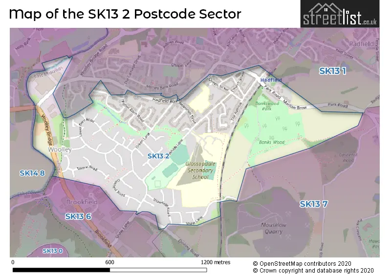
The SK13 2 postcode sector stands on the Derbyshire and Greater Manchester border.
Did you know? According to the 2021 Census, the SK13 2 postcode sector is home to a bustling 3,605 residents!
Given that each sector allows for 400 unique postcode combinations. Letters C, I, K, M, O and V are not allowed in the last two letters of a postcode. With 82 postcodes already in use, this leaves 318 units available.
The SK13 2 postal code covers the settlement of Hadfield.
The SK13 2 Postcode shares a border with SK13 6 (GLOSSOP, Gamesley), SK13 7 (GLOSSOP), SK14 8 (Hollingworth) and SK13 1 (Hadfield, Tintwistle, Padfield).
The sector is within the post town of GLOSSOP.
SK13 2 is a postcode sector within the SK13 postcode district which is within the SK Stockport postcode area.
The Royal Mail delivery office for the SK13 2 postal sector is the Hyde Delivery Office and Hadfield Scale Payment Delivery Office.
The area of the SK13 2 postcode sector is 0.45 square miles which is 1.16 square kilometres or 286.58 square acres.
Waterways within the SK13 2 postcode sector include the River Etherow.

Map of the SK13 2 Postcode Sector
Explore the SK13 2 postcode sector by using our free interactive map.
| S | K | 1 | 3 | - | 2 | X | X |
| S | K | 1 | 3 | Space | 2 | Letter | Letter |
Official List of Streets
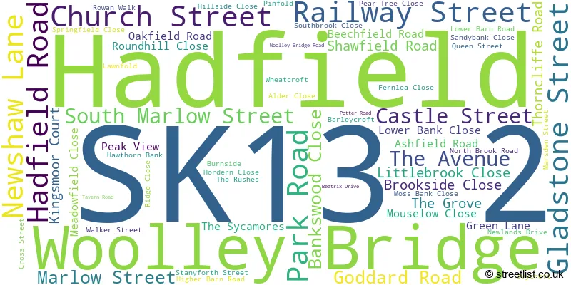
Hadfield (62 Streets)
Woolley Bridge (1 Streets)
Unofficial Streets or Alternative Spellings
GLOSSOP
BROOKFIELD DINTING ROAD SHAW LANEHollingworth
WATER LANE WOOLLEY LANEWeather Forecast for SK13 2
Press Button to Show Forecast for Woolley Bridge
| Time Period | Icon | Description | Temperature | Rain Probability | Wind |
|---|---|---|---|---|---|
| 21:00 to 00:00 | Cloudy | 6.0°C (feels like 4.0°C) | 3.00% | NE 7 mph |
Press Button to Show Forecast for Woolley Bridge
| Time Period | Icon | Description | Temperature | Rain Probability | Wind |
|---|---|---|---|---|---|
| 00:00 to 03:00 | Partly cloudy (night) | 4.0°C (feels like 3.0°C) | 1.00% | NE 4 mph | |
| 03:00 to 06:00 | Partly cloudy (night) | 3.0°C (feels like 2.0°C) | 1.00% | N 2 mph | |
| 06:00 to 09:00 | Sunny day | 4.0°C (feels like 2.0°C) | 1.00% | NNE 2 mph | |
| 09:00 to 12:00 | Cloudy | 7.0°C (feels like 6.0°C) | 3.00% | NW 4 mph | |
| 12:00 to 15:00 | Overcast | 10.0°C (feels like 8.0°C) | 8.00% | NNW 7 mph | |
| 15:00 to 18:00 | Overcast | 11.0°C (feels like 9.0°C) | 8.00% | N 7 mph | |
| 18:00 to 21:00 | Cloudy | 10.0°C (feels like 9.0°C) | 5.00% | N 4 mph | |
| 21:00 to 00:00 | Cloudy | 8.0°C (feels like 7.0°C) | 4.00% | NNE 4 mph |
Press Button to Show Forecast for Woolley Bridge
| Time Period | Icon | Description | Temperature | Rain Probability | Wind |
|---|---|---|---|---|---|
| 00:00 to 03:00 | Cloudy | 6.0°C (feels like 5.0°C) | 4.00% | ENE 4 mph | |
| 03:00 to 06:00 | Cloudy | 6.0°C (feels like 5.0°C) | 12.00% | ENE 2 mph | |
| 06:00 to 09:00 | Overcast | 6.0°C (feels like 5.0°C) | 17.00% | NE 2 mph | |
| 09:00 to 12:00 | Cloudy | 7.0°C (feels like 6.0°C) | 9.00% | NE 4 mph | |
| 12:00 to 15:00 | Cloudy | 9.0°C (feels like 8.0°C) | 10.00% | NE 4 mph | |
| 15:00 to 18:00 | Cloudy | 11.0°C (feels like 9.0°C) | 9.00% | NE 7 mph | |
| 18:00 to 21:00 | Cloudy | 10.0°C (feels like 9.0°C) | 8.00% | NE 7 mph | |
| 21:00 to 00:00 | Cloudy | 8.0°C (feels like 7.0°C) | 8.00% | ENE 4 mph |
Press Button to Show Forecast for Woolley Bridge
| Time Period | Icon | Description | Temperature | Rain Probability | Wind |
|---|---|---|---|---|---|
| 00:00 to 03:00 | Cloudy | 7.0°C (feels like 5.0°C) | 8.00% | E 4 mph | |
| 03:00 to 06:00 | Cloudy | 6.0°C (feels like 5.0°C) | 12.00% | SE 2 mph | |
| 06:00 to 09:00 | Cloudy | 6.0°C (feels like 5.0°C) | 13.00% | SSE 2 mph | |
| 09:00 to 12:00 | Light rain | 7.0°C (feels like 6.0°C) | 43.00% | SSW 4 mph | |
| 12:00 to 15:00 | Cloudy | 9.0°C (feels like 8.0°C) | 16.00% | S 4 mph | |
| 15:00 to 18:00 | Overcast | 10.0°C (feels like 9.0°C) | 20.00% | ENE 4 mph | |
| 18:00 to 21:00 | Cloudy | 10.0°C (feels like 9.0°C) | 16.00% | N 4 mph | |
| 21:00 to 00:00 | Cloudy | 9.0°C (feels like 8.0°C) | 11.00% | ENE 4 mph |
Press Button to Show Forecast for Woolley Bridge
| Time Period | Icon | Description | Temperature | Rain Probability | Wind |
|---|---|---|---|---|---|
| 00:00 to 03:00 | Cloudy | 8.0°C (feels like 7.0°C) | 8.00% | E 4 mph | |
| 03:00 to 06:00 | Cloudy | 7.0°C (feels like 6.0°C) | 6.00% | E 4 mph | |
| 06:00 to 09:00 | Partly cloudy (day) | 7.0°C (feels like 5.0°C) | 3.00% | NE 4 mph | |
| 09:00 to 12:00 | Cloudy | 9.0°C (feels like 7.0°C) | 5.00% | NE 7 mph | |
| 12:00 to 15:00 | Cloudy | 11.0°C (feels like 9.0°C) | 6.00% | NE 9 mph | |
| 15:00 to 18:00 | Cloudy | 12.0°C (feels like 10.0°C) | 9.00% | NE 9 mph | |
| 18:00 to 21:00 | Sunny day | 11.0°C (feels like 9.0°C) | 5.00% | NE 9 mph | |
| 21:00 to 00:00 | Clear night | 9.0°C (feels like 7.0°C) | 2.00% | NE 7 mph |
Schools and Places of Education Within the SK13 2 Postcode Sector
Glossopdale School and Sixth Form
Academy sponsor led
Newshaw Lane, Glossop, Derbyshire, SK13 2DA
Head: Mrs Debra McGloin
Ofsted Rating: Good
Inspection: 2023-11-15 (156 days ago)
Website: Visit Glossopdale School and Sixth Form Website
Phone: 01457862336
Number of Pupils: 1246
Hadfield Nursery School
Local authority nursery school
Queen Street, Glossop, Derbyshire, SK13 2DW
Head: Mr Kenneth Weed
Ofsted Rating: Outstanding
Inspection: 2018-03-06 (2236 days ago)
Website: Visit Hadfield Nursery School Website
Phone: 01457852297
Number of Pupils: 102
St Andrew's CofE Junior School
Voluntary controlled school
Hadfield Road, Glossop, Derbyshire, SK13 2DR
Head: Mrs Amanda Cornwall
Ofsted Rating: Good
Inspection: 2021-11-24 (877 days ago)
Website: Visit St Andrew's CofE Junior School Website
Phone: 01457852328
Number of Pupils: 230
House Prices in the SK13 2 Postcode Sector
| Type of Property | 2018 Average | 2018 Sales | 2017 Average | 2017 Sales | 2016 Average | 2016 Sales | 2015 Average | 2015 Sales |
|---|---|---|---|---|---|---|---|---|
| Detached | £256,402 | 26 | £219,905 | 11 | £218,846 | 13 | £205,222 | 9 |
| Semi-Detached | £178,881 | 16 | £184,369 | 16 | £156,739 | 18 | £158,731 | 13 |
| Terraced | £148,038 | 23 | £146,600 | 35 | £136,272 | 32 | £135,097 | 26 |
| Flats | £109,667 | 3 | £116,983 | 3 | £87,750 | 4 | £114,371 | 12 |
Important Postcodes SK13 2 in the Postcode Sector
SK13 2DR is the postcode for BLOCK 04 - WITH RECEPTION, St. Andrews C of E (Controlled) Junior School, Hadfield Road, and BLOCK 01 - WITH HALL, St. Andrews C of E (Controlled) Junior School, Hadfield Road
SK13 2DW is the postcode for Hadfield Nursery School, Queen Street
| The SK13 2 Sector is within these Local Authorities |
|
|---|---|
| The SK13 2 Sector is within these Counties |
|
| The SK13 2 Sector is within these Water Company Areas |
|