The SK13 7 postcode sector is within the county of Derbyshire.
Did you know? According to the 2021 Census, the SK13 7 postcode sector is home to a bustling 4,606 residents!
Given that each sector allows for 400 unique postcode combinations. Letters C, I, K, M, O and V are not allowed in the last two letters of a postcode. With 148 postcodes already in use, this leaves 252 units available.
The SK13 7 postal code covers the settlement of GLOSSOP.
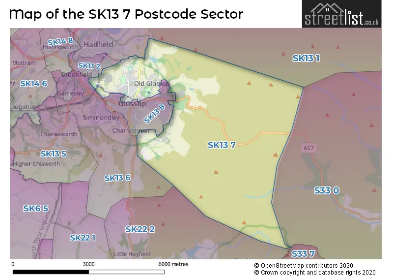
The SK13 7 Postcode shares a border with SK13 2 (Hadfield), SK13 6 (GLOSSOP, Gamesley), SK13 8 (GLOSSOP), SK22 2 (Hayfield, Little Hayfield), SK13 1 (Hadfield, Tintwistle, Padfield), S33 0 (Bamford) and S33 7 (Edale).
The sector is within the post town of GLOSSOP.
SK13 7 is a postcode sector within the SK13 postcode district which is within the SK Stockport postcode area.
The Royal Mail delivery office for the SK13 7 postal sector is the Glossop Delivery Office.
The area of the SK13 7 postcode sector is 13.63 square miles which is 35.29 square kilometres or 8,721.46 square acres.
Waterways within the SK13 7 postcode sector include the River Ashop, River Kinder, Shelf Brook, Yellowslacks Brook, Dovestone Clough, Glossop Brook.

Map of the SK13 7 Postcode Sector
Explore the SK13 7 postcode sector by using our free interactive map.
| S | K | 1 | 3 | - | 7 | X | X |
| S | K | 1 | 3 | Space | 7 | Letter | Letter |
Official List of Streets
GLOSSOP (106 Streets)
Unofficial Streets or Alternative Spellings
Bamford
SNAKE ROADTintwistle
WOODHEAD ROADGLOSSOP
CHUNAL LANE CORN STREET CROFT PARK ELLISON STREET HENRY STREET SHAW LANE WOODCOCK ROAD YORK STREET DOCTORS GATE FAUVEL PLACE HILLTOP ROAD KINGSMOOR FIELDS MANOR PARK VIEW MILL COURT SNAKE PASS SNAKE PATH TURF PITS LANE WARDS CROSSING FOOTBRIDGE WELL GATEHadfield
PARK ROAD SHAWFIELD ROADLittle Padfield
REDGATEWeather Forecast for SK13 7
Press Button to Show Forecast for Snake Pass
| Time Period | Icon | Description | Temperature | Rain Probability | Wind |
|---|---|---|---|---|---|
| 06:00 to 09:00 | Fog | 2.0°C (feels like -3.0°C) | 47.00% | W 13 mph | |
| 09:00 to 12:00 | Sleet | 3.0°C (feels like -2.0°C) | 52.00% | WNW 11 mph | |
| 12:00 to 15:00 | Overcast | 3.0°C (feels like -1.0°C) | 14.00% | NNE 9 mph | |
| 15:00 to 18:00 | Cloudy | 5.0°C (feels like 1.0°C) | 12.00% | NNE 9 mph | |
| 18:00 to 21:00 | Cloudy | 4.0°C (feels like 0.0°C) | 6.00% | ENE 9 mph | |
| 21:00 to 00:00 | Partly cloudy (night) | 1.0°C (feels like -2.0°C) | 2.00% | ENE 9 mph |
Press Button to Show Forecast for Snake Pass
| Time Period | Icon | Description | Temperature | Rain Probability | Wind |
|---|---|---|---|---|---|
| 00:00 to 03:00 | Clear night | 0.0°C (feels like -3.0°C) | 2.00% | ENE 7 mph | |
| 03:00 to 06:00 | Clear night | -1.0°C (feels like -4.0°C) | 1.00% | NE 7 mph | |
| 06:00 to 09:00 | Sunny day | 0.0°C (feels like -3.0°C) | 1.00% | NE 7 mph | |
| 09:00 to 12:00 | Cloudy | 2.0°C (feels like -1.0°C) | 5.00% | ENE 7 mph | |
| 12:00 to 15:00 | Overcast | 4.0°C (feels like 2.0°C) | 9.00% | E 4 mph | |
| 15:00 to 18:00 | Cloudy | 5.0°C (feels like 4.0°C) | 7.00% | E 4 mph | |
| 18:00 to 21:00 | Cloudy | 4.0°C (feels like 1.0°C) | 7.00% | E 7 mph | |
| 21:00 to 00:00 | Cloudy | 1.0°C (feels like -2.0°C) | 6.00% | E 7 mph |
Press Button to Show Forecast for Snake Pass
| Time Period | Icon | Description | Temperature | Rain Probability | Wind |
|---|---|---|---|---|---|
| 00:00 to 03:00 | Cloudy | 1.0°C (feels like -2.0°C) | 9.00% | ESE 7 mph | |
| 03:00 to 06:00 | Cloudy | 0.0°C (feels like -3.0°C) | 10.00% | ENE 7 mph | |
| 06:00 to 09:00 | Cloudy | 1.0°C (feels like -3.0°C) | 13.00% | ENE 9 mph | |
| 09:00 to 12:00 | Cloudy | 4.0°C (feels like 0.0°C) | 10.00% | E 11 mph | |
| 12:00 to 15:00 | Overcast | 5.0°C (feels like 2.0°C) | 18.00% | E 11 mph | |
| 15:00 to 18:00 | Cloudy | 6.0°C (feels like 2.0°C) | 20.00% | E 11 mph | |
| 18:00 to 21:00 | Cloudy | 5.0°C (feels like 1.0°C) | 18.00% | ENE 13 mph | |
| 21:00 to 00:00 | Cloudy | 3.0°C (feels like -2.0°C) | 17.00% | ENE 13 mph |
Press Button to Show Forecast for Snake Pass
| Time Period | Icon | Description | Temperature | Rain Probability | Wind |
|---|---|---|---|---|---|
| 00:00 to 03:00 | Light rain | 2.0°C (feels like -3.0°C) | 46.00% | NE 13 mph | |
| 03:00 to 06:00 | Overcast | 2.0°C (feels like -3.0°C) | 23.00% | NE 13 mph | |
| 06:00 to 09:00 | Light rain | 3.0°C (feels like -2.0°C) | 54.00% | NNE 16 mph | |
| 09:00 to 12:00 | Light rain | 4.0°C (feels like -1.0°C) | 56.00% | NNE 16 mph | |
| 12:00 to 15:00 | Heavy rain | 5.0°C (feels like 1.0°C) | 77.00% | NE 13 mph | |
| 15:00 to 18:00 | Light rain | 5.0°C (feels like 2.0°C) | 55.00% | N 13 mph | |
| 18:00 to 21:00 | Cloudy | 5.0°C (feels like 2.0°C) | 16.00% | N 11 mph | |
| 21:00 to 00:00 | Partly cloudy (night) | 4.0°C (feels like 0.0°C) | 8.00% | SSE 11 mph |
Schools and Places of Education Within the SK13 7 Postcode Sector
All Saints Catholic Voluntary Academy
Academy converter
Church Street, Glossop, Derbyshire, SK13 7RJ
Head: Mrs Grainne Beaumont
Ofsted Rating: Good
Inspection: 2022-12-06 (506 days ago)
Website: Visit All Saints Catholic Voluntary Academy Website
Phone: 01457852756
Number of Pupils: 71
Duke of Norfolk CofE Primary School
Voluntary controlled school
Royle Avenue, Glossop, Derbyshire, SK13 7RD
Head: Mrs Esther Bland
Ofsted Rating: Requires improvement
Inspection: 2021-10-06 (932 days ago)
Website: Visit Duke of Norfolk CofE Primary School Website
Phone: 01457852635
Number of Pupils: 315
St Luke's CofE Primary School
Voluntary controlled school
Spire Hollin, Glossop, Derbyshire, SK13 7BS
Head: Mrs Jakki Rogers
Ofsted Rating: Good
Inspection: 2021-06-16 (1044 days ago)
Website: Visit St Luke's CofE Primary School Website
Phone: 01457852602
Number of Pupils: 213
House Prices in the SK13 7 Postcode Sector
| Type of Property | 2018 Average | 2018 Sales | 2017 Average | 2017 Sales | 2016 Average | 2016 Sales | 2015 Average | 2015 Sales |
|---|---|---|---|---|---|---|---|---|
| Detached | £379,827 | 39 | £342,879 | 24 | £336,007 | 25 | £333,706 | 18 |
| Semi-Detached | £251,542 | 33 | £225,782 | 35 | £236,999 | 14 | £223,395 | 10 |
| Terraced | £177,523 | 66 | £173,893 | 48 | £139,971 | 19 | £150,697 | 43 |
| Flats | £146,596 | 13 | £168,014 | 11 | £118,325 | 10 | £119,486 | 7 |
Important Postcodes SK13 7 in the Postcode Sector
SK13 7BQ is the postcode for WARD BLOCK, Woods Hospital, Park Crescent, and Pennine Care NHS Trust, Woods Hospital
SK13 7BS is the postcode for Main Building, St. Luke's C of E Controlled Primary School, Spire Hollin, St Lukes Primary School, Spire Hollin, and St. Luke's C of E Controlled Primary School, Spire Hollin
SK13 7DE is the postcode for Howard Street Group Practice, Howard Street
SK13 7DF is the postcode for Glossop Jobcentre Plus, Howard Street
SK13 7DG is the postcode for Glossop Adult Education Centre and Library, Talbot Street, Victoria Hall, Talbot Street, High Peak Area Social Service Office, Talbot Street, and Whole Building, Glossop Adult Education Centre and Glossop Library, Talbot Street
SK13 7DS is the postcode for Glossop Victorian Swimming Pool, Dinting Road
SK13 7PZ is the postcode for Tameside and Glossop PCT, Shire Hill Hospital
SK13 7QP is the postcode for Shire Hill Hospital, Ward Block, and Shire Hill Hospital, Administration Block
SK13 7RD is the postcode for The Duke of Norfolk C of E Primary School, Royle Avenue, and MODULAR BUILDING, The Duke of Norfolk C of E Primary School, Royle Avenue
SK13 7RJ is the postcode for All Saints Catholic Voluntary Academy, Church Street
| The SK13 7 Sector is within these Local Authorities |
|
|---|---|
| The SK13 7 Sector is within these Counties |
|
| The SK13 7 Sector is within these Water Company Areas |
|