The SK15 1 postcode sector is within the county of Greater Manchester.
Did you know? According to the 2021 Census, the SK15 1 postcode sector is home to a bustling 9,519 residents!
Given that each sector allows for 400 unique postcode combinations. Letters C, I, K, M, O and V are not allowed in the last two letters of a postcode. With 227 postcodes already in use, this leaves 173 units available.
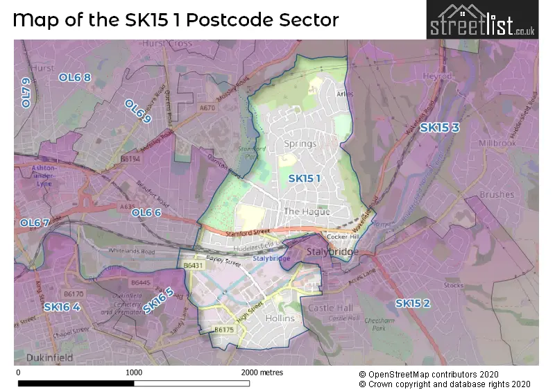
The SK15 1 postal code covers the settlement of STALYBRIDGE.
The SK15 1 Postcode shares a border with OL6 6 (ASHTON-UNDER-LYNE), SK15 2 (STALYBRIDGE, Matley), OL6 9 (ASHTON-UNDER-LYNE), SK15 3 (STALYBRIDGE, Carrbrook, Millbrook) and SK16 5 (DUKINFIELD).
The sector is within the post town of STALYBRIDGE.
SK15 1 is a postcode sector within the SK15 postcode district which is within the SK Stockport postcode area.
The Royal Mail delivery office for the SK15 1 postal sector is the Ashton Under Lyne Delivery Office.
The area of the SK15 1 postcode sector is 0.94 square miles which is 2.45 square kilometres or 604.18 square acres.
Waterways within the SK15 1 postcode sector include the Huddersfield Narrow Canal.

Map of the SK15 1 Postcode Sector
Explore the SK15 1 postcode sector by using our free interactive map.
| S | K | 1 | 5 | - | 1 | X | X |
| S | K | 1 | 5 | Space | 1 | Letter | Letter |
Official List of Streets
STALYBRIDGE (152 Streets)
Unofficial Streets or Alternative Spellings
STALYBRIDGE
ARLIES LANE CASTLE HALL COURT FORESTER DRIVE MARKET STREET OFF RIDGE HILL LANE TRINITY STREET WATERLOO ROAD ALBERT SQUARE BACK MELBOURNE STREET BENNETT STREET BLANDFORD STREET BOROUGH STREET CANAL STREET CARTER STREET CHADWICK CLOSE DALE STREET DUKE STREET FORRESTER DRIVE GEORGE STREET GORSE HALL DRIVE LAKE VIEW LARK HILL MERE SIDE MOUNT STREET RICHMOND HOUSE SPRING STREET TINTAGEL COURT WOOD STREET WORTHINGTON STREETHeyrod
WAKEFIELD ROADDUKINFIELD,
CHEETHAM HILL ROAD LABURNUM AVENUE LORD STREET MOSTYN STREETASHTON-UNDER-LYNE
FREDERICK STREET MELLOR CLOSE MELLOR ROAD PARK CRESCENT SYCAMORE CLOSE WHITELANDS ROAD WILLOW WOOD CLOSEDUKINFIELD
BELVEDERE DRIVE HIGH CROFT CLOSE JAMES CLOSE PARK ROAD SANDY LANEASHTON-UNDER-LYNE,
DARNTON ROADWeather Forecast for SK15 1
Press Button to Show Forecast for Ridge Hill
| Time Period | Icon | Description | Temperature | Rain Probability | Wind |
|---|---|---|---|---|---|
| 21:00 to 00:00 | Light rain | 8.0°C (feels like 5.0°C) | 62.00% | W 13 mph |
Press Button to Show Forecast for Ridge Hill
| Time Period | Icon | Description | Temperature | Rain Probability | Wind |
|---|---|---|---|---|---|
| 00:00 to 03:00 | Light rain | 8.0°C (feels like 5.0°C) | 55.00% | WNW 13 mph | |
| 03:00 to 06:00 | Light rain | 8.0°C (feels like 5.0°C) | 42.00% | WNW 13 mph | |
| 06:00 to 09:00 | Cloudy | 7.0°C (feels like 4.0°C) | 11.00% | NW 13 mph | |
| 09:00 to 12:00 | Cloudy | 8.0°C (feels like 5.0°C) | 8.00% | NW 13 mph | |
| 12:00 to 15:00 | Cloudy | 10.0°C (feels like 7.0°C) | 43.00% | NW 16 mph | |
| 15:00 to 18:00 | Cloudy | 10.0°C (feels like 8.0°C) | 30.00% | NNW 11 mph | |
| 18:00 to 21:00 | Cloudy | 9.0°C (feels like 7.0°C) | 8.00% | N 9 mph | |
| 21:00 to 00:00 | Cloudy | 6.0°C (feels like 4.0°C) | 5.00% | NE 7 mph |
Press Button to Show Forecast for Ridge Hill
| Time Period | Icon | Description | Temperature | Rain Probability | Wind |
|---|---|---|---|---|---|
| 00:00 to 03:00 | Cloudy | 5.0°C (feels like 3.0°C) | 4.00% | NNE 4 mph | |
| 03:00 to 06:00 | Partly cloudy (night) | 4.0°C (feels like 2.0°C) | 1.00% | NNE 4 mph | |
| 06:00 to 09:00 | Cloudy | 4.0°C (feels like 2.0°C) | 5.00% | NNE 4 mph | |
| 09:00 to 12:00 | Sunny day | 7.0°C (feels like 5.0°C) | 2.00% | N 7 mph | |
| 12:00 to 15:00 | Overcast | 9.0°C (feels like 8.0°C) | 8.00% | N 7 mph | |
| 15:00 to 18:00 | Overcast | 11.0°C (feels like 9.0°C) | 10.00% | N 7 mph | |
| 18:00 to 21:00 | Cloudy | 10.0°C (feels like 9.0°C) | 6.00% | N 7 mph | |
| 21:00 to 00:00 | Partly cloudy (night) | 8.0°C (feels like 6.0°C) | 2.00% | N 4 mph |
Press Button to Show Forecast for Ridge Hill
| Time Period | Icon | Description | Temperature | Rain Probability | Wind |
|---|---|---|---|---|---|
| 00:00 to 03:00 | Partly cloudy (night) | 6.0°C (feels like 5.0°C) | 2.00% | N 2 mph | |
| 03:00 to 06:00 | Cloudy | 6.0°C (feels like 5.0°C) | 7.00% | ENE 2 mph | |
| 06:00 to 09:00 | Cloudy | 6.0°C (feels like 5.0°C) | 7.00% | NE 2 mph | |
| 09:00 to 12:00 | Cloudy | 8.0°C (feels like 8.0°C) | 10.00% | N 4 mph | |
| 12:00 to 15:00 | Cloudy | 10.0°C (feels like 9.0°C) | 8.00% | NNE 7 mph | |
| 15:00 to 18:00 | Cloudy | 11.0°C (feels like 10.0°C) | 10.00% | NE 7 mph | |
| 18:00 to 21:00 | Cloudy | 10.0°C (feels like 9.0°C) | 7.00% | NE 7 mph | |
| 21:00 to 00:00 | Partly cloudy (night) | 8.0°C (feels like 7.0°C) | 4.00% | NE 7 mph |
Press Button to Show Forecast for Ridge Hill
| Time Period | Icon | Description | Temperature | Rain Probability | Wind |
|---|---|---|---|---|---|
| 00:00 to 03:00 | Cloudy | 7.0°C (feels like 5.0°C) | 7.00% | ENE 4 mph | |
| 03:00 to 06:00 | Cloudy | 6.0°C (feels like 5.0°C) | 7.00% | E 4 mph | |
| 06:00 to 09:00 | Cloudy | 6.0°C (feels like 5.0°C) | 8.00% | ENE 4 mph | |
| 09:00 to 12:00 | Cloudy | 8.0°C (feels like 6.0°C) | 11.00% | E 4 mph | |
| 12:00 to 15:00 | Cloudy | 10.0°C (feels like 8.0°C) | 9.00% | E 7 mph | |
| 15:00 to 18:00 | Cloudy | 11.0°C (feels like 9.0°C) | 14.00% | NE 7 mph | |
| 18:00 to 21:00 | Partly cloudy (day) | 10.0°C (feels like 9.0°C) | 9.00% | ENE 7 mph | |
| 21:00 to 00:00 | Cloudy | 8.0°C (feels like 7.0°C) | 7.00% | NE 4 mph |
Schools and Places of Education Within the SK15 1 Postcode Sector
Arlies Primary School
Community school
Broadhill Road, Stalybridge, Cheshire, SK15 1HQ
Head: Mrs Lucy Hughes
Ofsted Rating: Good
Inspection: 2023-05-18 (336 days ago)
Website: Visit Arlies Primary School Website
Phone: 01613384854
Number of Pupils: 208
Silver Springs Primary Academy
Academy sponsor led
School Crescent, Stalybridge, Cheshire, SK15 1EA
Head: Deborah Mason
Ofsted Rating: Good
Inspection: 2022-07-06 (652 days ago)
Website: Visit Silver Springs Primary Academy Website
Phone: 01613382475
Number of Pupils: 387
West Hill School
Academy converter
Thompson Cross, Stalybridge, Cheshire, SK15 1LX
Head: Claire Cronin
Ofsted Rating: Good
Inspection: 2021-11-24 (876 days ago)
Website: Visit West Hill School Website
Phone: 01613382193
Number of Pupils: 834
House Prices in the SK15 1 Postcode Sector
| Type of Property | 2018 Average | 2018 Sales | 2017 Average | 2017 Sales | 2016 Average | 2016 Sales | 2015 Average | 2015 Sales |
|---|---|---|---|---|---|---|---|---|
| Detached | £203,500 | 13 | £207,300 | 5 | £197,250 | 6 | £187,857 | 7 |
| Semi-Detached | £161,956 | 34 | £141,134 | 32 | £126,918 | 41 | £123,800 | 27 |
| Terraced | £107,831 | 75 | £103,388 | 67 | £101,736 | 61 | £90,327 | 54 |
| Flats | £77,540 | 5 | £109,438 | 8 | £103,607 | 7 | £69,278 | 9 |
Important Postcodes SK15 1 in the Postcode Sector
SK15 1EA is the postcode for Silver Springs Primary Academy, School Crescent, and Silver Springs Academy, School Crescent
SK15 1HQ is the postcode for Arlies Primary School, Broadhill Road
SK15 1JF is the postcode for Samuel Laycock Special School, Mereside
SK15 1LX is the postcode for ART AND TECHNOLOGY, West Hill School, Stamford Street, SPORTS HALL, West Hill School, Stamford Street, THE HEWITT BUILDING, West Hill School, Stamford Street, and MAIN SCHOOL, West Hill School, Stamford Street
SK15 1RF is the postcode for MAIN BUILDING, Greater Manchester Fire & Rescue Service, Fire Station, Rassbottom Street
SK15 1RZ is the postcode for Grosvenor Medical Centre, 62 Grosvenor Street
SK15 1ST is the postcode for Tame Street Depot, Tame Street
| The SK15 1 Sector is within these Local Authorities |
|
|---|---|
| The SK15 1 Sector is within these Counties |
|
| The SK15 1 Sector is within these Water Company Areas |
|