The SK3 8 postcode sector is within the county of Greater Manchester.
Did you know? According to the 2021 Census, the SK3 8 postcode sector is home to a bustling 12,340 residents!
Given that each sector allows for 400 unique postcode combinations. Letters C, I, K, M, O and V are not allowed in the last two letters of a postcode. With 212 postcodes already in use, this leaves 188 units available.
The SK3 8 postal code covers the settlement of STOCKPORT.
The SK3 8 Postcode shares a border with SK3 9 (STOCKPORT), SK2 6 (STOCKPORT), SK8 5 (Cheadle Hulme), SK2 7 (STOCKPORT), SK3 0 (STOCKPORT), SK7 3 (Bramhall) and SK1 3 (STOCKPORT).
The sector is within the post town of STOCKPORT.
SK3 8 is a postcode sector within the SK3 postcode district which is within the SK Stockport postcode area.
The Royal Mail delivery office for the SK3 8 postal sector is the Stockport Central Delivery Office and Stockport 3 Delivery Office and Stockport 1 Delivery Office.
The area of the SK3 8 postcode sector is 0.93 square miles which is 2.41 square kilometres or 595.79 square acres.

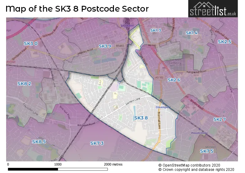
Map of the SK3 8 Postcode Sector
Explore the SK3 8 postcode sector by using our free interactive map.
| S | K | 3 | - | 8 | X | X |
| S | K | 3 | Space | 8 | Letter | Letter |
Official List of Streets
STOCKPORT (146 Streets)
Unofficial Streets or Alternative Spellings
STOCKPORT
BLACKSHAW STREET BOOTH STREET CHARLESWORTH STREET EUROPA WAY HARPER COURT HOPE TERRACE JUNCTION ROAD LONGSHUT LANE WEST SPECTRUM WAY STOCKHOLM ROAD THE GROVE THOMSON STREET ARMOURY ROUNDABOUT BERET CLOSE BOATER STREET BOWLER PLACE DAVENPORT LODGE HARRISON GROVE HATTER AVENUE HOLMES STREET KELSALL CRESCENT MULBERRY MOUNT STREET NIXON STREET OLIVER STREET PANAMA CLOSE SCHOOL COURT TRILBY DRIVE WHEAT CROFT WOODS MOOR LANECheadle Hulme
ADSWOOD ROADBramhall
BRAMHALL LANE SOUTHWeather Forecast for SK3 8
Press Button to Show Forecast for Davenport
| Time Period | Icon | Description | Temperature | Rain Probability | Wind |
|---|---|---|---|---|---|
| 12:00 to 15:00 | Light rain | 8.0°C (feels like 6.0°C) | 51.00% | N 7 mph | |
| 15:00 to 18:00 | Light rain | 8.0°C (feels like 7.0°C) | 50.00% | NNW 4 mph | |
| 18:00 to 21:00 | Cloudy | 8.0°C (feels like 7.0°C) | 12.00% | NE 4 mph | |
| 21:00 to 00:00 | Cloudy | 6.0°C (feels like 4.0°C) | 9.00% | ENE 7 mph |
Press Button to Show Forecast for Davenport
| Time Period | Icon | Description | Temperature | Rain Probability | Wind |
|---|---|---|---|---|---|
| 00:00 to 03:00 | Partly cloudy (night) | 4.0°C (feels like 2.0°C) | 2.00% | E 4 mph | |
| 03:00 to 06:00 | Partly cloudy (night) | 2.0°C (feels like 0.0°C) | 1.00% | ENE 4 mph | |
| 06:00 to 09:00 | Partly cloudy (day) | 3.0°C (feels like 1.0°C) | 1.00% | ENE 4 mph | |
| 09:00 to 12:00 | Cloudy | 7.0°C (feels like 5.0°C) | 6.00% | ENE 4 mph | |
| 12:00 to 15:00 | Overcast | 9.0°C (feels like 8.0°C) | 10.00% | E 4 mph | |
| 15:00 to 18:00 | Cloudy | 9.0°C (feels like 9.0°C) | 8.00% | ESE 4 mph | |
| 18:00 to 21:00 | Cloudy | 9.0°C (feels like 8.0°C) | 7.00% | NE 4 mph | |
| 21:00 to 00:00 | Partly cloudy (night) | 5.0°C (feels like 3.0°C) | 5.00% | ENE 7 mph |
Press Button to Show Forecast for Davenport
| Time Period | Icon | Description | Temperature | Rain Probability | Wind |
|---|---|---|---|---|---|
| 00:00 to 03:00 | Partly cloudy (night) | 4.0°C (feels like 1.0°C) | 8.00% | ENE 4 mph | |
| 03:00 to 06:00 | Partly cloudy (night) | 3.0°C (feels like 0.0°C) | 6.00% | ENE 4 mph | |
| 06:00 to 09:00 | Cloudy | 4.0°C (feels like 2.0°C) | 8.00% | ENE 7 mph | |
| 09:00 to 12:00 | Cloudy | 8.0°C (feels like 6.0°C) | 8.00% | E 7 mph | |
| 12:00 to 15:00 | Overcast | 10.0°C (feels like 8.0°C) | 16.00% | E 9 mph | |
| 15:00 to 18:00 | Cloudy | 10.0°C (feels like 8.0°C) | 17.00% | E 9 mph | |
| 18:00 to 21:00 | Cloudy | 9.0°C (feels like 7.0°C) | 18.00% | ENE 9 mph | |
| 21:00 to 00:00 | Cloudy | 7.0°C (feels like 4.0°C) | 16.00% | ENE 9 mph |
Press Button to Show Forecast for Davenport
| Time Period | Icon | Description | Temperature | Rain Probability | Wind |
|---|---|---|---|---|---|
| 00:00 to 03:00 | Cloudy | 6.0°C (feels like 3.0°C) | 20.00% | NE 9 mph | |
| 03:00 to 06:00 | Cloudy | 6.0°C (feels like 3.0°C) | 16.00% | NE 9 mph | |
| 06:00 to 09:00 | Light rain | 6.0°C (feels like 4.0°C) | 50.00% | NNE 9 mph | |
| 09:00 to 12:00 | Heavy rain | 8.0°C (feels like 5.0°C) | 74.00% | NNE 11 mph | |
| 12:00 to 15:00 | Heavy rain | 9.0°C (feels like 6.0°C) | 78.00% | NNE 11 mph | |
| 15:00 to 18:00 | Heavy rain | 9.0°C (feels like 7.0°C) | 75.00% | N 9 mph | |
| 18:00 to 21:00 | Cloudy | 10.0°C (feels like 8.0°C) | 19.00% | NNW 9 mph | |
| 21:00 to 00:00 | Partly cloudy (night) | 7.0°C (feels like 5.0°C) | 12.00% | NW 7 mph |
Schools and Places of Education Within the SK3 8 Postcode Sector
Adswood Primary School
Community school
Garners Lane, Stockport, Cheshire, SK3 8PQ
Head: Mrs Michelle Smart
Ofsted Rating: Good
Inspection: 2019-11-13 (1625 days ago)
Website: Visit Adswood Primary School Website
Phone: 01614835003
Number of Pupils: 331
Bridge Hall Primary School
Community school
Cuddington Crescent, Stockport, Cheshire, SK3 8LX
Head: Mrs Alexandra Jamieson
Ofsted Rating: Good
Inspection: 2019-05-22 (1800 days ago)
Website: Visit Bridge Hall Primary School Website
Phone: 01614807889
Number of Pupils: 214
Cale Green Primary School
Community school
Shaw Road South, Stockport, Cheshire, SK3 8JG
Head: Mrs S McHugh
Ofsted Rating: Good
Inspection: 2022-01-26 (820 days ago)
Website: Visit Cale Green Primary School Website
Phone: 01614802715
Number of Pupils: 340
St Ambrose Catholic Primary School
Voluntary aided school
Rostrevor Road, Stockport, Cheshire, SK3 8LQ
Head: Mr Michael Glynn
Ofsted Rating: Good
Inspection: 2023-07-19 (281 days ago)
Website: Visit St Ambrose Catholic Primary School Website
Phone: 01614808466
Number of Pupils: 182
House Prices in the SK3 8 Postcode Sector
| Type of Property | 2018 Average | 2018 Sales | 2017 Average | 2017 Sales | 2016 Average | 2016 Sales | 2015 Average | 2015 Sales |
|---|---|---|---|---|---|---|---|---|
| Detached | £319,819 | 18 | £256,834 | 23 | £327,225 | 20 | £290,886 | 18 |
| Semi-Detached | £215,169 | 75 | £194,719 | 77 | £192,558 | 85 | £171,812 | 79 |
| Terraced | £149,081 | 58 | £144,151 | 72 | £147,959 | 58 | £126,169 | 63 |
| Flats | £114,038 | 25 | £118,184 | 16 | £96,691 | 17 | £108,441 | 17 |
Important Postcodes SK3 8 in the Postcode Sector
SK3 8AB is the postcode for ART GALLERY AND WAR MEMORIAL, GREEK STREET
SK3 8DN is the postcode for Shaw Heath Health Centre, Gilmore Street
SK3 8JG is the postcode for Cale Green Primary School, Shaw Road South
SK3 8LQ is the postcode for St. Ambrose RC Primary School, Rostrevor Road
SK3 8NR is the postcode for Bridge Hall Primary School, Siddington Avenue, and Bridge Hall Primary School (old), Siddington Avenue
SK3 8QJ is the postcode for Adswood Primary School, Garners Lane, and ADSWOOD PRIMARY SCHOOL, GARNERS LANE, ADSWOOD
SK3 8QW is the postcode for Abacus Children's Centre, 120 Garners Lane, and Abacus Childrens Centre, 120 Garners Lane
| The SK3 8 Sector is within these Local Authorities |
|
|---|---|
| The SK3 8 Sector is within these Counties |
|
| The SK3 8 Sector is within these Water Company Areas |
|