The SK5 8 postcode sector is within the county of Greater Manchester.
Did you know? According to the 2021 Census, the SK5 8 postcode sector is home to a bustling 8,230 residents!
Given that each sector allows for 400 unique postcode combinations. Letters C, I, K, M, O and V are not allowed in the last two letters of a postcode. With 146 postcodes already in use, this leaves 254 units available.
The SK5 8 postal code covers the settlement of STOCKPORT.
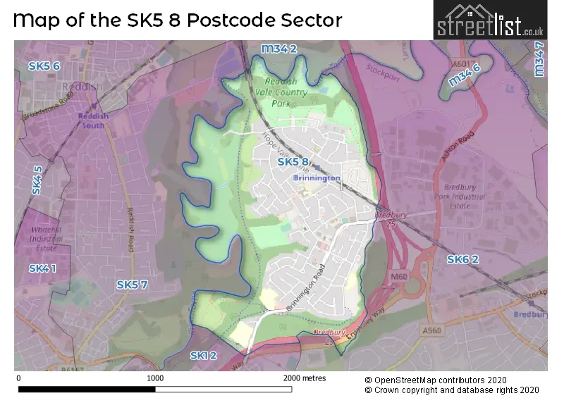
The SK5 8 Postcode shares a border with SK1 2 (STOCKPORT), SK6 2 (Bredbury), M34 2 (Denton) and SK5 7 (STOCKPORT).
The sector is within the post town of STOCKPORT.
SK5 8 is a postcode sector within the SK5 postcode district which is within the SK Stockport postcode area.
The Royal Mail delivery office for the SK5 8 postal sector is the Stockport Central Delivery Office and Stockport 5 Delivery Office and Stockport 1 Delivery Office.
The area of the SK5 8 postcode sector is 0.87 square miles which is 2.25 square kilometres or 555.39 square acres.
The SK5 8 postcode sector is crossed by the M60 motorway.
Waterways within the SK5 8 postcode sector include the River Tame.

Map of the SK5 8 Postcode Sector
Explore the SK5 8 postcode sector by using our free interactive map.
| S | K | 5 | - | 8 | X | X |
| S | K | 5 | Space | 8 | Letter | Letter |
Official List of Streets
STOCKPORT (95 Streets)
Unofficial Streets or Alternative Spellings
Weather Forecast for SK5 8
Press Button to Show Forecast for Brinnington
| Time Period | Icon | Description | Temperature | Rain Probability | Wind |
|---|---|---|---|---|---|
| 12:00 to 15:00 | Cloudy | 9.0°C (feels like 7.0°C) | 3.00% | N 9 mph | |
| 15:00 to 18:00 | Cloudy | 11.0°C (feels like 9.0°C) | 4.00% | NNW 7 mph | |
| 18:00 to 21:00 | Partly cloudy (day) | 10.0°C (feels like 8.0°C) | 1.00% | NNW 9 mph | |
| 21:00 to 00:00 | Partly cloudy (night) | 7.0°C (feels like 5.0°C) | 1.00% | NNW 7 mph |
Press Button to Show Forecast for Brinnington
| Time Period | Icon | Description | Temperature | Rain Probability | Wind |
|---|---|---|---|---|---|
| 00:00 to 03:00 | Partly cloudy (night) | 6.0°C (feels like 4.0°C) | 2.00% | W 4 mph | |
| 03:00 to 06:00 | Cloudy | 5.0°C (feels like 3.0°C) | 6.00% | WSW 7 mph | |
| 06:00 to 09:00 | Cloudy | 6.0°C (feels like 4.0°C) | 8.00% | W 7 mph | |
| 09:00 to 12:00 | Partly cloudy (day) | 8.0°C (feels like 5.0°C) | 7.00% | NW 9 mph | |
| 12:00 to 15:00 | Cloudy | 10.0°C (feels like 8.0°C) | 8.00% | NW 9 mph | |
| 15:00 to 18:00 | Overcast | 10.0°C (feels like 8.0°C) | 10.00% | NW 9 mph | |
| 18:00 to 21:00 | Cloudy | 9.0°C (feels like 7.0°C) | 7.00% | N 7 mph | |
| 21:00 to 00:00 | Light rain | 7.0°C (feels like 5.0°C) | 39.00% | ENE 4 mph |
Press Button to Show Forecast for Brinnington
| Time Period | Icon | Description | Temperature | Rain Probability | Wind |
|---|---|---|---|---|---|
| 00:00 to 03:00 | Cloudy | 5.0°C (feels like 3.0°C) | 8.00% | ESE 4 mph | |
| 03:00 to 06:00 | Cloudy | 4.0°C (feels like 2.0°C) | 9.00% | ESE 4 mph | |
| 06:00 to 09:00 | Overcast | 5.0°C (feels like 3.0°C) | 11.00% | ESE 4 mph | |
| 09:00 to 12:00 | Cloudy | 7.0°C (feels like 5.0°C) | 12.00% | ESE 7 mph | |
| 12:00 to 15:00 | Overcast | 9.0°C (feels like 7.0°C) | 14.00% | ESE 7 mph | |
| 15:00 to 18:00 | Overcast | 10.0°C (feels like 8.0°C) | 15.00% | ESE 7 mph | |
| 18:00 to 21:00 | Cloudy | 9.0°C (feels like 7.0°C) | 10.00% | ESE 7 mph | |
| 21:00 to 00:00 | Cloudy | 7.0°C (feels like 5.0°C) | 13.00% | E 7 mph |
Press Button to Show Forecast for Brinnington
| Time Period | Icon | Description | Temperature | Rain Probability | Wind |
|---|---|---|---|---|---|
| 00:00 to 03:00 | Cloudy | 6.0°C (feels like 4.0°C) | 15.00% | E 7 mph | |
| 03:00 to 06:00 | Light rain | 6.0°C (feels like 3.0°C) | 45.00% | E 7 mph | |
| 06:00 to 09:00 | Cloudy | 6.0°C (feels like 4.0°C) | 18.00% | E 7 mph | |
| 09:00 to 12:00 | Cloudy | 8.0°C (feels like 6.0°C) | 15.00% | E 9 mph | |
| 12:00 to 15:00 | Cloudy | 10.0°C (feels like 8.0°C) | 18.00% | E 9 mph | |
| 15:00 to 18:00 | Cloudy | 11.0°C (feels like 9.0°C) | 15.00% | ENE 9 mph | |
| 18:00 to 21:00 | Cloudy | 10.0°C (feels like 8.0°C) | 12.00% | ENE 9 mph | |
| 21:00 to 00:00 | Cloudy | 9.0°C (feels like 6.0°C) | 13.00% | NE 9 mph |
Schools and Places of Education Within the SK5 8 Postcode Sector
Highfields College
Pupil referral unit
Highfields, Essex Road, Stockport, Cheshire, SK5 8DR
Head: Mr Matt Grant
Ofsted Rating: Good
Inspection: 2020-01-29 (1547 days ago)
Website: Visit Highfields College Website
Phone: 01614067922
Number of Pupils: 99
St Bernadette's Catholic Primary School
Voluntary aided school
Foliage Road, Stockport, Cheshire, SK5 8AR
Head: Ms S Jones
Ofsted Rating: Good
Inspection: 2020-03-12 (1504 days ago)
Website: Visit St Bernadette's Catholic Primary School Website
Phone: 01614304601
Number of Pupils: 224
St Paul's Church of England Primary School Brinnington
Voluntary controlled school
Brinnington Rise, Stockport, Cheshire, SK5 8AA
Head: Miss Joanne Harrington
Ofsted Rating: Good
Inspection: 2019-02-28 (1882 days ago)
Website: Visit St Paul's Church of England Primary School Brinnington Website
Phone: 01614805403
Number of Pupils: 391
Westmorland Primary School
Community school
Westmorland Drive, Stockport, Cheshire, SK5 8HH
Head: Mr Martin Henderson
Ofsted Rating: Good
Inspection: 2023-07-19 (280 days ago)
Website: Visit Westmorland Primary School Website
Phone: 01614069403
Number of Pupils: 497
House Prices in the SK5 8 Postcode Sector
| Type of Property | 2018 Average | 2018 Sales | 2017 Average | 2017 Sales | 2016 Average | 2016 Sales | 2015 Average | 2015 Sales |
|---|---|---|---|---|---|---|---|---|
| Detached | £199,445 | 18 | £188,412 | 13 | £0 | 0 | £120,000 | 1 |
| Semi-Detached | £159,072 | 57 | £138,613 | 48 | £108,441 | 17 | £91,385 | 26 |
| Terraced | £129,477 | 24 | £86,727 | 24 | £79,731 | 18 | £81,335 | 23 |
| Flats | £0 | 0 | £61,000 | 1 | £79,125 | 4 | £0 | 0 |
Important Postcodes SK5 8 in the Postcode Sector
SK5 8AA is the postcode for St Paul's C E Primary, Brinnington Rise, Brinnington, St Paul's C E Primary, Brinnington Rise, and St. Pauls Primary School, Brinnington Road
SK5 8AR is the postcode for ST BERNADETTES CATHOLIC PRIMARY SCHOOL, GORSEWAY, BRINNINGTON, and St. Bernadettes RC Primary School, Gorseway
SK5 8BS is the postcode for Brinnington Health Centre, Brinnington Road
SK5 8DR is the postcode for HIGHFIELDS, ESSEX ROAD, BRINNINGTON, and Highfields, Essex Road
SK5 8HH is the postcode for Brinnington Early Years Centre, Westmorland Drive, WESTMORLAND PRIMARY SCHOOL, WESTMORLAND DRIVE, BRINNINGTON, and Westmorland Primary School, Westmorland Drive
SK5 8LA is the postcode for Westmorland Primary School, Blackberry Lane
SK5 8LF is the postcode for Castle Hill School, Lapwing Lane, and Lapwing Recreation Centre, Lapwing Lane
SK5 8LS is the postcode for Brinnington Leisure Centre, Northumberland Road
| The SK5 8 Sector is within these Local Authorities |
|
|---|---|
| The SK5 8 Sector is within these Counties |
|
| The SK5 8 Sector is within these Water Company Areas |
|