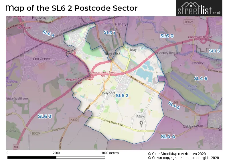
The SL6 2 postcode sector stands on the Berkshire and Buckinghamshire border.
Did you know? According to the 2021 Census, the SL6 2 postcode sector is home to a bustling 10,816 residents!
Given that each sector allows for 400 unique postcode combinations. Letters C, I, K, M, O and V are not allowed in the last two letters of a postcode. With 273 postcodes already in use, this leaves 127 units available.
The largest settlement in the SL6 2 postal code is MAIDENHEAD followed by Holyport, and Bray.
The SL6 2 Postcode shares a border with SL4 4 (WINDSOR, Winkfield, Oakley Green), SL6 1 (MAIDENHEAD), SL4 5 (WINDSOR, Water Oakley, Oakley Green), SL4 6 (Eton Wick, Eton, Dorney), SL6 0 (Taplow, Dorney Reach), SL6 3 (MAIDENHEAD, White Waltham, Littlewick Green) and SL6 4 (MAIDENHEAD).
The sector is within the post town of MAIDENHEAD.
SL6 2 is a postcode sector within the SL6 postcode district which is within the SL Slough postcode area.
The Royal Mail delivery office for the SL6 2 postal sector is the Maidenhead Delivery Office.
The area of the SL6 2 postcode sector is 4.90 square miles which is 12.70 square kilometres or 3,139.15 square acres.
The SL6 2 postcode sector is crossed by the A404M Major A road.
The SL6 2 postcode sector is crossed by the A308M Major A road.
The SL6 2 postcode sector is crossed by the M4 motorway.
Waterways within the SL6 2 postcode sector include the River Thames, York Stream.

Map of the SL6 2 Postcode Sector
Explore the SL6 2 postcode sector by using our free interactive map.
| S | L | 6 | - | 2 | X | X |
| S | L | 6 | Space | 2 | Letter | Letter |
Official List of Streets
MAIDENHEAD (73 Streets)
Holyport (31 Streets)
Bray (19 Streets)
Unofficial Streets or Alternative Spellings
MAIDENHEAD
BLACKBIRD LANE BRAY ROAD BRAYWICK ROAD DHOON RISE HIBBERT ROAD KING STREET LONG LANE NORREYS DRIVE RUSHINGTON AVENUE THE CROFTOakley Green
OAKLEY GREEN ROADWinkfield
FIFIELD LANEBray
BETTONEY VERE BRAY BRIDGE BRAYWICK ROUNDABOUT CANNON HILL CLOSE CHAPEL COURT CHURCH DRIVE CRESSWELLS FARM FOREST GREEN GREEN LANE HANOVER MEAD HOLYPORT INTERCHANGE LANGDOWN WAY LINKSIDE MONKEY ISLAND LAEN MONKEY ISLAND LN MOOR FARM PAMELA ROW PHILBERDS LODGE PLATFROM 1 WHEELCHAIR ACCESS RAMP PRIMROSE LANE REGAL COURT ROBINSON COURT SPRING HILL SUMMERLEAZE BRIDGE THE RETREAT THRIFT LANE VICARAGE DRIVE WEST COURTWater Oakley
WINDSOR ROADWeather Forecast for SL6 2
Press Button to Show Forecast for Dorney Court
| Time Period | Icon | Description | Temperature | Rain Probability | Wind |
|---|---|---|---|---|---|
| 00:00 to 03:00 | Cloudy | 9.0°C (feels like 6.0°C) | 40.00% | WSW 13 mph | |
| 03:00 to 06:00 | Cloudy | 10.0°C (feels like 7.0°C) | 13.00% | W 13 mph | |
| 06:00 to 09:00 | Cloudy | 10.0°C (feels like 7.0°C) | 15.00% | WNW 11 mph | |
| 09:00 to 12:00 | Overcast | 11.0°C (feels like 8.0°C) | 10.00% | NW 13 mph | |
| 12:00 to 15:00 | Cloudy | 12.0°C (feels like 10.0°C) | 10.00% | NW 16 mph | |
| 15:00 to 18:00 | Cloudy | 13.0°C (feels like 10.0°C) | 9.00% | NNW 13 mph | |
| 18:00 to 21:00 | Cloudy | 10.0°C (feels like 8.0°C) | 9.00% | N 11 mph | |
| 21:00 to 00:00 | Cloudy | 8.0°C (feels like 7.0°C) | 5.00% | NNE 7 mph |
Press Button to Show Forecast for Dorney Court
| Time Period | Icon | Description | Temperature | Rain Probability | Wind |
|---|---|---|---|---|---|
| 00:00 to 03:00 | Partly cloudy (night) | 6.0°C (feels like 4.0°C) | 1.00% | N 7 mph | |
| 03:00 to 06:00 | Partly cloudy (night) | 5.0°C (feels like 2.0°C) | 1.00% | NNW 7 mph | |
| 06:00 to 09:00 | Cloudy | 5.0°C (feels like 2.0°C) | 5.00% | NNW 7 mph | |
| 09:00 to 12:00 | Overcast | 8.0°C (feels like 5.0°C) | 8.00% | N 11 mph | |
| 12:00 to 15:00 | Overcast | 10.0°C (feels like 8.0°C) | 8.00% | N 9 mph | |
| 15:00 to 18:00 | Overcast | 11.0°C (feels like 9.0°C) | 8.00% | N 9 mph | |
| 18:00 to 21:00 | Overcast | 10.0°C (feels like 8.0°C) | 8.00% | N 9 mph | |
| 21:00 to 00:00 | Cloudy | 8.0°C (feels like 6.0°C) | 5.00% | NNE 4 mph |
Press Button to Show Forecast for Dorney Court
| Time Period | Icon | Description | Temperature | Rain Probability | Wind |
|---|---|---|---|---|---|
| 00:00 to 03:00 | Partly cloudy (night) | 6.0°C (feels like 5.0°C) | 2.00% | N 4 mph | |
| 03:00 to 06:00 | Partly cloudy (night) | 5.0°C (feels like 4.0°C) | 2.00% | NNW 4 mph | |
| 06:00 to 09:00 | Cloudy | 6.0°C (feels like 4.0°C) | 6.00% | N 4 mph | |
| 09:00 to 12:00 | Cloudy | 8.0°C (feels like 6.0°C) | 6.00% | NNE 7 mph | |
| 12:00 to 15:00 | Overcast | 10.0°C (feels like 8.0°C) | 10.00% | NNE 9 mph | |
| 15:00 to 18:00 | Cloudy | 11.0°C (feels like 9.0°C) | 8.00% | NNE 9 mph | |
| 18:00 to 21:00 | Partly cloudy (day) | 11.0°C (feels like 8.0°C) | 3.00% | NNE 9 mph | |
| 21:00 to 00:00 | Partly cloudy (night) | 8.0°C (feels like 6.0°C) | 3.00% | NE 9 mph |
Press Button to Show Forecast for Dorney Court
| Time Period | Icon | Description | Temperature | Rain Probability | Wind |
|---|---|---|---|---|---|
| 00:00 to 03:00 | Partly cloudy (night) | 6.0°C (feels like 4.0°C) | 3.00% | NNE 7 mph | |
| 03:00 to 06:00 | Partly cloudy (night) | 5.0°C (feels like 3.0°C) | 3.00% | NNE 7 mph | |
| 06:00 to 09:00 | Partly cloudy (day) | 6.0°C (feels like 3.0°C) | 3.00% | NNE 7 mph | |
| 09:00 to 12:00 | Cloudy | 9.0°C (feels like 7.0°C) | 6.00% | NE 9 mph | |
| 12:00 to 15:00 | Cloudy | 11.0°C (feels like 9.0°C) | 8.00% | NE 9 mph | |
| 15:00 to 18:00 | Cloudy | 11.0°C (feels like 9.0°C) | 10.00% | NNE 11 mph | |
| 18:00 to 21:00 | Cloudy | 10.0°C (feels like 8.0°C) | 8.00% | NNE 9 mph | |
| 21:00 to 00:00 | Partly cloudy (night) | 8.0°C (feels like 6.0°C) | 4.00% | NE 7 mph |
Schools and Places of Education Within the SL6 2 Postcode Sector
Desborough College
Academy sponsor led
Shoppenhangers Road, Maidenhead, Berkshire, SL6 2QB
Head: Mr Andrew Murdoch
Ofsted Rating: Good
Inspection: 2019-02-12 (1893 days ago)
Website: Visit Desborough College Website
Phone: 01628634505
Number of Pupils: 837
Holyport CofE Primary School
Academy converter
Stroud Farm Road, Maidenhead, Berkshire, SL6 2LP
Head: Amanda Featherstone
Ofsted Rating: Good
Inspection: 2019-05-01 (1815 days ago)
Website: Visit Holyport CofE Primary School Website
Phone: 01628627743
Number of Pupils: 229
Larchfield Primary and Nursery School
Community school
Bargeman Road, Maidenhead, Berkshire, SL6 2SG
Head: Ms Jacqui Kearney
Ofsted Rating: Good
Inspection: 2019-03-26 (1851 days ago)
Website: Visit Larchfield Primary and Nursery School Website
Phone: 01628622522
Number of Pupils: 228
House Prices in the SL6 2 Postcode Sector
| Type of Property | 2018 Average | 2018 Sales | 2017 Average | 2017 Sales | 2016 Average | 2016 Sales | 2015 Average | 2015 Sales |
|---|---|---|---|---|---|---|---|---|
| Detached | £754,715 | 44 | £828,332 | 51 | £779,670 | 38 | £689,904 | 37 |
| Semi-Detached | £467,328 | 37 | £445,867 | 31 | £470,142 | 36 | £453,359 | 23 |
| Terraced | £474,586 | 22 | £469,750 | 24 | £430,862 | 33 | £425,502 | 31 |
| Flats | £306,271 | 40 | £290,234 | 31 | £329,196 | 39 | £296,466 | 44 |
Important Postcodes SL6 2 in the Postcode Sector
SL6 2LP is the postcode for The Holyport Surgery, Stroud Farm Road, and Holyport C of E Primary School, Stroud Farm Road
SL6 2QB is the postcode for REYNOLDS BUILDING, Desborough College, Shoppenhangers Road, Desborough College, Shoppenhangers Road, Main Building (Old), Desborough College, MAIN BUILDING (NEW), Desborough College, Shoppenhangers Road, BROOKS BUILDING, Desborough College, Shoppenhangers Road, MAUDSLEY BUILDING, Desborough College, Shoppenhangers Road, MAIN BUILDING (OLD), Desborough College, Shoppenhangers Road, MODULAR ENGLISH BLOCK, Desborough College, Shoppenhangers Road, and SPORTS HALL, Desborough College, Shoppenhangers Road
SL6 2SG is the postcode for Larchfield Primary and Nursery School, Bargeman Road
| The SL6 2 Sector is within these Local Authorities |
|
|---|---|
| The SL6 2 Sector is within these Counties |
|
| The SL6 2 Sector is within these Water Company Areas |
|