The SL9 8 postcode sector is within the county of Buckinghamshire.
Did you know? According to the 2021 Census, the SL9 8 postcode sector is home to a bustling 4,793 residents!
Given that each sector allows for 400 unique postcode combinations. Letters C, I, K, M, O and V are not allowed in the last two letters of a postcode. With 242 postcodes already in use, this leaves 158 units available.
The largest settlement in the SL9 8 postal code is GERRARDS CROSS followed by Chalfont St. Peter, and CHALFONT ST PETER.
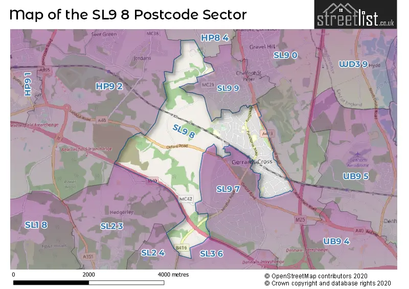
The SL9 8 Postcode shares a border with SL9 0 (CHALFONT ST PETER, Chalfont St. Peter, GERRARDS CROSS), SL9 7 (GERRARDS CROSS, DENHAM, FULMER), SL9 9 (Chalfont St. Peter, CHALFONT ST PETER), SL2 3 (Farnham Common, Farnham Royal, Hedgerley), SL2 4 (Stoke Poges, Wexham), SL3 6 (Wexham, George Green, FULMER), HP8 4 (CHALFONT ST. GILES, CHALFONT ST GILES, LITTLE CHALFONT) and HP9 2 (BEACONSFIELD, Seer Green, Jordans).
The sector is within the post town of GERRARDS CROSS.
SL9 8 is a postcode sector within the SL9 postcode district which is within the SL Slough postcode area.
The Royal Mail delivery office for the SL9 8 postal sector is the Gerrards Cross Delivery Office.
The area of the SL9 8 postcode sector is 3.44 square miles which is 8.91 square kilometres or 2,200.56 square acres.
The SL9 8 postcode sector is crossed by the M40 motorway.
Waterways within the SL9 8 postcode sector include the River Missbourne.

Map of the SL9 8 Postcode Sector
Explore the SL9 8 postcode sector by using our free interactive map.
| S | L | 9 | - | 8 | X | X |
| S | L | 9 | Space | 8 | Letter | Letter |
Official List of Streets
Chalfont St. Peter (31 Streets)
GERRARDS CROSS (40 Streets)
Unofficial Streets or Alternative Spellings
GERRARDS CROSS
BULSTRODE WAY LAYTERS WAYChalfont St. Peter
AMERSHAM ROAD AUSTENWOOD CLOSE AUSTENWOOD LANE CHALFONT PARK GROVE LANE LEACHCROFT SCHOOL LANEStoke Poges
WINDSOR ROADDenham
OXFORD ROADBEACONSFIELD,
HEDGERLEY LANEWeather Forecast for SL9 8
Press Button to Show Forecast for Jordans Youth Hostel
| Time Period | Icon | Description | Temperature | Rain Probability | Wind |
|---|---|---|---|---|---|
| 00:00 to 03:00 | Clear night | 4.0°C (feels like 1.0°C) | 0.00% | N 7 mph | |
| 03:00 to 06:00 | Clear night | 3.0°C (feels like 0.0°C) | 0.00% | NNW 7 mph | |
| 06:00 to 09:00 | Partly cloudy (day) | 3.0°C (feels like 1.0°C) | 1.00% | NNW 7 mph | |
| 09:00 to 12:00 | Cloudy | 8.0°C (feels like 5.0°C) | 4.00% | N 11 mph | |
| 12:00 to 15:00 | Cloudy | 10.0°C (feels like 8.0°C) | 4.00% | N 11 mph | |
| 15:00 to 18:00 | Cloudy | 11.0°C (feels like 9.0°C) | 4.00% | N 11 mph | |
| 18:00 to 21:00 | Cloudy | 9.0°C (feels like 8.0°C) | 4.00% | NNE 7 mph | |
| 21:00 to 00:00 | Partly cloudy (night) | 6.0°C (feels like 5.0°C) | 1.00% | NE 4 mph |
Press Button to Show Forecast for Jordans Youth Hostel
| Time Period | Icon | Description | Temperature | Rain Probability | Wind |
|---|---|---|---|---|---|
| 00:00 to 03:00 | Cloudy | 5.0°C (feels like 4.0°C) | 4.00% | NNE 4 mph | |
| 03:00 to 06:00 | Partly cloudy (night) | 5.0°C (feels like 2.0°C) | 3.00% | N 4 mph | |
| 06:00 to 09:00 | Overcast | 5.0°C (feels like 3.0°C) | 8.00% | N 7 mph | |
| 09:00 to 12:00 | Overcast | 7.0°C (feels like 5.0°C) | 9.00% | NNE 9 mph | |
| 12:00 to 15:00 | Overcast | 9.0°C (feels like 7.0°C) | 10.00% | NNE 11 mph | |
| 15:00 to 18:00 | Cloudy | 10.0°C (feels like 8.0°C) | 6.00% | NNE 11 mph | |
| 18:00 to 21:00 | Partly cloudy (day) | 9.0°C (feels like 7.0°C) | 4.00% | NNE 9 mph | |
| 21:00 to 00:00 | Clear night | 6.0°C (feels like 4.0°C) | 3.00% | NNE 9 mph |
Press Button to Show Forecast for Jordans Youth Hostel
| Time Period | Icon | Description | Temperature | Rain Probability | Wind |
|---|---|---|---|---|---|
| 00:00 to 03:00 | Clear night | 4.0°C (feels like 2.0°C) | 3.00% | NNE 7 mph | |
| 03:00 to 06:00 | Partly cloudy (night) | 3.0°C (feels like 1.0°C) | 2.00% | N 4 mph | |
| 06:00 to 09:00 | Partly cloudy (day) | 4.0°C (feels like 2.0°C) | 4.00% | N 4 mph | |
| 09:00 to 12:00 | Cloudy | 7.0°C (feels like 6.0°C) | 9.00% | NNE 7 mph | |
| 12:00 to 15:00 | Cloudy | 9.0°C (feels like 8.0°C) | 13.00% | NNW 7 mph | |
| 15:00 to 18:00 | Overcast | 9.0°C (feels like 8.0°C) | 18.00% | N 7 mph | |
| 18:00 to 21:00 | Overcast | 8.0°C (feels like 6.0°C) | 19.00% | NNW 7 mph | |
| 21:00 to 00:00 | Light rain | 7.0°C (feels like 5.0°C) | 45.00% | NNW 4 mph |
Press Button to Show Forecast for Jordans Youth Hostel
| Time Period | Icon | Description | Temperature | Rain Probability | Wind |
|---|---|---|---|---|---|
| 00:00 to 03:00 | Cloudy | 6.0°C (feels like 4.0°C) | 11.00% | N 4 mph | |
| 03:00 to 06:00 | Cloudy | 5.0°C (feels like 4.0°C) | 9.00% | NNE 4 mph | |
| 06:00 to 09:00 | Cloudy | 6.0°C (feels like 4.0°C) | 9.00% | NNE 7 mph | |
| 09:00 to 12:00 | Overcast | 8.0°C (feels like 6.0°C) | 10.00% | NNE 9 mph | |
| 12:00 to 15:00 | Overcast | 10.0°C (feels like 8.0°C) | 18.00% | NNE 9 mph | |
| 15:00 to 18:00 | Overcast | 11.0°C (feels like 9.0°C) | 17.00% | NNE 9 mph | |
| 18:00 to 21:00 | Cloudy | 10.0°C (feels like 8.0°C) | 8.00% | NNE 9 mph | |
| 21:00 to 00:00 | Partly cloudy (night) | 7.0°C (feels like 5.0°C) | 2.00% | NNE 7 mph |
Schools and Places of Education Within the SL9 8 Postcode Sector
The Chalfonts Community College
Academy converter
Narcot Lane, Gerrards Cross, Buckinghamshire, SL9 8TP
Head: Mrs Caroline Whitehead
Ofsted Rating: Good
Inspection: 2022-11-02 (535 days ago)
Website: Visit The Chalfonts Community College Website
Phone: 01753882032
Number of Pupils: 1336
The Gerrards Cross CofE School
Academy converter
Moreland Drive, Gerrards Cross, Buckinghamshire, SL9 8BD
Head: Mrs Nicola Flower
Ofsted Rating: Outstanding
Inspection: 2014-06-13 (3599 days ago)
Website: Visit The Gerrards Cross CofE School Website
Phone: 01753882731
Number of Pupils: 421
House Prices in the SL9 8 Postcode Sector
| Type of Property | 2018 Average | 2018 Sales | 2017 Average | 2017 Sales | 2016 Average | 2016 Sales | 2015 Average | 2015 Sales |
|---|---|---|---|---|---|---|---|---|
| Detached | £1,488,582 | 33 | £1,381,594 | 31 | £1,357,504 | 51 | £1,386,482 | 44 |
| Semi-Detached | £630,000 | 2 | £800,930 | 10 | £1,040,365 | 9 | £873,667 | 6 |
| Terraced | £405,000 | 3 | £665,000 | 7 | £778,556 | 9 | £718,750 | 4 |
| Flats | £681,000 | 18 | £803,099 | 40 | £751,120 | 27 | £475,461 | 27 |
Important Postcodes SL9 8 in the Postcode Sector
SL9 8BD is the postcode for BLOCK 2, Gerrards Cross C of E School, Moreland Drive, and BLOCK 1, Gerrards Cross C of E School, Moreland Drive
SL9 8EL is the postcode for Buckinghamshire County Council, Gerrards Cross Library, 38 Station Road
SL9 8GX is the postcode for Royal Mail, Gerrards Cross Delivery Office, 2 Marsham Way
SL9 8SB is the postcode for BLOCK 2, St. Josephs RC Combined School, Priory Road, St. Josephs RC Combined School, Priory Road, and St Josephs Catholic Primary School, Priory Road
SL9 8TP is the postcode for BLOCK 4, The Chalfonts Community College, Narcot Lane, BLOCK 3, The Chalfonts Community College, Narcot Lane, BLOCK 5 RUBICON ARTS & ENGLISH CENTRE, The Chalfonts Community College, Narcot Lane, BLOCK 8 CHIKARA CENTRE, The Chalfonts Community College, Narcot Lane, BLOCK 5, The Chalfonts Community College, Narcot Lane, BLOCK 4 MERIDIAN BUILDING, The Chalfonts Community College, Narcot Lane, MAIN, JAVA, RUBICON BLOCK, The Chalfonts Community College, Narcot Lane, BLOCKS 1 & 2, The Chalfonts Community College, Narcot Lane, BLOCK 3 ICT/MATHS CORRIDOR BUILDING, The Chalfonts Community College, Narcot Lane, BLOCKS 1&2 MAIN & JAVA BUILDING, The Chalfonts Community College, Narcot Lane, BLOCK 1, The Chalfonts Community College, Narcot Lane, BLOCK 8, The Chalfonts Community College, Narcot Lane, and The Chalfonts Community College, Narcot Lane
| The SL9 8 Sector is within these Local Authorities |
|
|---|---|
| The SL9 8 Sector is within these Counties |
|
| The SL9 8 Sector is within these Water Company Areas |
|