The SN12 8 postcode sector is within the county of Wiltshire.
Did you know? According to the 2021 Census, the SN12 8 postcode sector is home to a bustling 6,416 residents!
Given that each sector allows for 400 unique postcode combinations. Letters C, I, K, M, O and V are not allowed in the last two letters of a postcode. With 206 postcodes already in use, this leaves 194 units available.
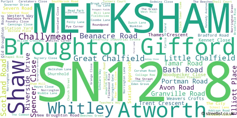
The largest settlement in the SN12 8 postal code is MELKSHAM followed by Atworth, and Broughton Gifford.
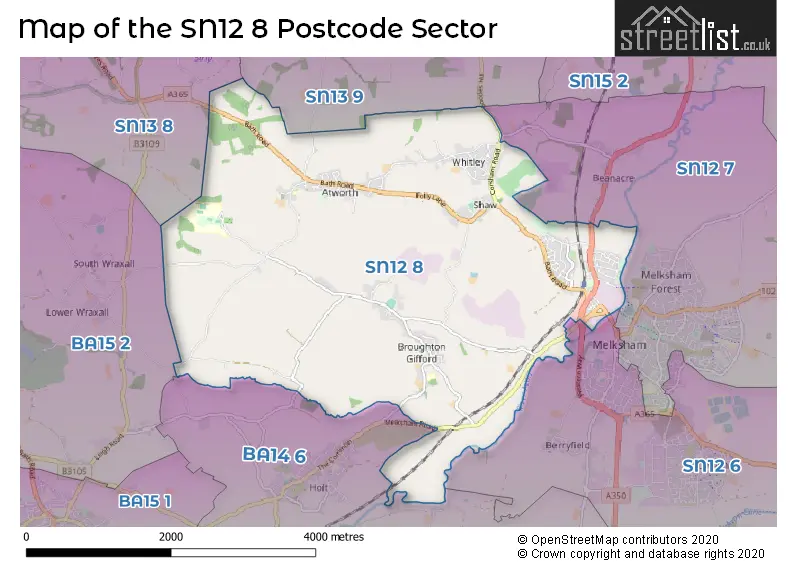
The SN12 8 Postcode shares a border with BA15 2 (Winsley, BRADFORD-ON-AVON, Lower Westwood), SN12 6 (MELKSHAM, Bowerhill, Seend), SN12 7 (MELKSHAM, Beanacre, Forest), SN13 8 (Box, Kingsdown, Box Hill), SN13 9 (CORSHAM, Neston, Gastard) and BA14 6 (Holt, Steeple Ashton, Semington).
The sector is within the post town of MELKSHAM.
SN12 8 is a postcode sector within the SN12 postcode district which is within the SN Swindon postcode area.
The Royal Mail delivery office for the SN12 8 postal sector is the Melksham Delivery Office.
The area of the SN12 8 postcode sector is 8.60 square miles which is 22.28 square kilometres or 5,505.22 square acres.
Waterways within the SN12 8 postcode sector include the River Avon.

Map of the SN12 8 Postcode Sector
Explore the SN12 8 postcode sector by using our free interactive map.
| S | N | 1 | 2 | - | 8 | X | X |
| S | N | 1 | 2 | Space | 8 | Letter | Letter |
Official List of Streets
MELKSHAM (40 Streets)
Whitley (15 Streets)
Atworth (17 Streets)
Shaw (7 Streets)
Broughton Gifford (15 Streets)
Unofficial Streets or Alternative Spellings
Weather Forecast for SN12 8
Press Button to Show Forecast for Melksham
| Time Period | Icon | Description | Temperature | Rain Probability | Wind |
|---|---|---|---|---|---|
| 03:00 to 06:00 | Clear night | 5.0°C (feels like 3.0°C) | 0.00% | WSW 4 mph | |
| 06:00 to 09:00 | Partly cloudy (day) | 5.0°C (feels like 3.0°C) | 1.00% | W 4 mph | |
| 09:00 to 12:00 | Cloudy | 9.0°C (feels like 7.0°C) | 51.00% | W 7 mph | |
| 12:00 to 15:00 | Light rain | 11.0°C (feels like 8.0°C) | 51.00% | W 9 mph | |
| 15:00 to 18:00 | Light rain shower (day) | 12.0°C (feels like 10.0°C) | 50.00% | NW 7 mph | |
| 18:00 to 21:00 | Cloudy | 10.0°C (feels like 8.0°C) | 14.00% | NW 7 mph | |
| 21:00 to 00:00 | Cloudy | 8.0°C (feels like 6.0°C) | 16.00% | NE 4 mph |
Press Button to Show Forecast for Melksham
| Time Period | Icon | Description | Temperature | Rain Probability | Wind |
|---|---|---|---|---|---|
| 00:00 to 03:00 | Cloudy | 7.0°C (feels like 5.0°C) | 5.00% | NE 4 mph | |
| 03:00 to 06:00 | Cloudy | 5.0°C (feels like 4.0°C) | 6.00% | NE 4 mph | |
| 06:00 to 09:00 | Cloudy | 5.0°C (feels like 3.0°C) | 7.00% | ENE 7 mph | |
| 09:00 to 12:00 | Cloudy | 8.0°C (feels like 5.0°C) | 8.00% | E 9 mph | |
| 12:00 to 15:00 | Overcast | 10.0°C (feels like 8.0°C) | 16.00% | E 7 mph | |
| 15:00 to 18:00 | Overcast | 10.0°C (feels like 9.0°C) | 19.00% | E 7 mph | |
| 18:00 to 21:00 | Cloudy | 10.0°C (feels like 8.0°C) | 16.00% | ENE 7 mph | |
| 21:00 to 00:00 | Cloudy | 7.0°C (feels like 5.0°C) | 12.00% | ENE 7 mph |
Press Button to Show Forecast for Melksham
| Time Period | Icon | Description | Temperature | Rain Probability | Wind |
|---|---|---|---|---|---|
| 00:00 to 03:00 | Cloudy | 6.0°C (feels like 4.0°C) | 18.00% | ENE 7 mph | |
| 03:00 to 06:00 | Cloudy | 5.0°C (feels like 3.0°C) | 21.00% | ENE 7 mph | |
| 06:00 to 09:00 | Light rain | 5.0°C (feels like 3.0°C) | 53.00% | NE 7 mph | |
| 09:00 to 12:00 | Overcast | 8.0°C (feels like 5.0°C) | 21.00% | NE 9 mph | |
| 12:00 to 15:00 | Overcast | 11.0°C (feels like 9.0°C) | 19.00% | ENE 11 mph | |
| 15:00 to 18:00 | Cloudy | 12.0°C (feels like 9.0°C) | 19.00% | ENE 11 mph | |
| 18:00 to 21:00 | Light rain | 10.0°C (feels like 8.0°C) | 52.00% | NE 11 mph | |
| 21:00 to 00:00 | Light rain | 9.0°C (feels like 6.0°C) | 49.00% | NE 11 mph |
Press Button to Show Forecast for Melksham
| Time Period | Icon | Description | Temperature | Rain Probability | Wind |
|---|---|---|---|---|---|
| 00:00 to 03:00 | Light rain | 8.0°C (feels like 5.0°C) | 52.00% | NE 13 mph | |
| 03:00 to 06:00 | Heavy rain | 7.0°C (feels like 4.0°C) | 75.00% | NE 11 mph | |
| 06:00 to 09:00 | Light rain | 7.0°C (feels like 5.0°C) | 55.00% | NNE 9 mph | |
| 09:00 to 12:00 | Light rain | 9.0°C (feels like 6.0°C) | 51.00% | NE 11 mph | |
| 12:00 to 15:00 | Light rain | 10.0°C (feels like 7.0°C) | 50.00% | SW 13 mph | |
| 15:00 to 18:00 | Light rain | 11.0°C (feels like 8.0°C) | 49.00% | WNW 13 mph | |
| 18:00 to 21:00 | Light rain shower (day) | 11.0°C (feels like 9.0°C) | 33.00% | WNW 9 mph | |
| 21:00 to 00:00 | Partly cloudy (night) | 8.0°C (feels like 6.0°C) | 4.00% | S 4 mph |
Schools and Places of Education Within the SN12 8 Postcode Sector
Churchfields, the Village School
Voluntary controlled school
Bradford Road, Melksham, Wiltshire, SN12 8HY
Head: Mr Simon Futcher
Ofsted Rating: Good
Inspection: 2022-09-29 (574 days ago)
Website: Visit Churchfields, the Village School Website
Phone: 01225703026
Number of Pupils: 121
Shaw CE Primary School
Academy converter
Corsham Road, Melksham, , SN12 8EQ
Head: Mr Thomas Brewer
Ofsted Rating: Good
Inspection: 2022-11-03 (539 days ago)
Website: Visit Shaw CE Primary School Website
Phone: 01225702544
Number of Pupils: 201
St Mary's Broughton Gifford Voluntary Controlled Church of England Primary School
Academy converter
The Street, Melksham, Wiltshire, SN12 8PR
Head: Mrs Emma Hembury
Ofsted Rating: Good
Inspection: 2022-11-23 (519 days ago)
Website: Visit St Mary's Broughton Gifford Voluntary Controlled Church of England Primary School Website
Phone: 01225782223
Number of Pupils: 81
House Prices in the SN12 8 Postcode Sector
| Type of Property | 2018 Average | 2018 Sales | 2017 Average | 2017 Sales | 2016 Average | 2016 Sales | 2015 Average | 2015 Sales |
|---|---|---|---|---|---|---|---|---|
| Detached | £355,991 | 78 | £326,182 | 77 | £324,421 | 47 | £398,753 | 42 |
| Semi-Detached | £255,488 | 46 | £243,776 | 53 | £230,548 | 27 | £226,569 | 29 |
| Terraced | £202,945 | 27 | £199,513 | 30 | £225,162 | 40 | £196,227 | 29 |
| Flats | £103,083 | 6 | £138,160 | 10 | £146,526 | 23 | £107,857 | 7 |
Important Postcodes SN12 8 in the Postcode Sector
SN12 8DQ is the postcode for MAIN BUILDING, George Ward School, Shurnhold, UPPER SCHOOL, George Ward School, Shurnhold, and D. & T. BUILDING, George Ward School, Shurnhold
SN12 8EQ is the postcode for SCHOOL HALL, Shaw C of E School, Corsham Road, Shaw C of E School, Corsham Road, Shaw, and Shaw C of E School, Corsham Road
SN12 8GQ is the postcode for BLOCK 5, Wiltshire Council, Shurnhold Offices, Shurnhold, and BLOCK 3, Wiltshire Council, Shurnhold Offices, Shurnhold
SN12 8HY is the postcode for Churchfields the Village School, Bradford Road
SN12 8PR is the postcode for Broughton Gifford School, The Street
| The SN12 8 Sector is within these Local Authorities |
|
|---|---|
| The SN12 8 Sector is within these Counties |
|
| The SN12 8 Sector is within these Water Company Areas |
|
Tourist Attractions within the SN12 8 Postcode Area
We found 1 visitor attractions within the SN12 postcode area
| Great Chalfield Manor |
|---|
| Historic Properties |
| Historic House / House and Garden / Palace |
| View Great Chalfield Manor on Google Maps |