The SN13 9 postcode sector is within the county of Wiltshire.
Did you know? According to the 2021 Census, the SN13 9 postcode sector is home to a bustling 9,767 residents!
Given that each sector allows for 400 unique postcode combinations. Letters C, I, K, M, O and V are not allowed in the last two letters of a postcode. With 288 postcodes already in use, this leaves 112 units available.
The largest settlement in the SN13 9 postal code is CORSHAM followed by Neston, and Gastard.
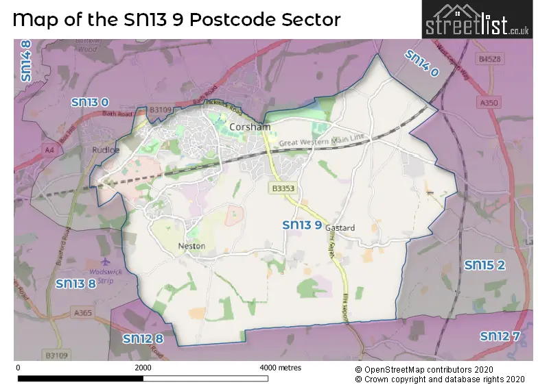
The SN13 9 Postcode shares a border with SN14 0 (CHIPPENHAM, Sheldon), SN12 7 (MELKSHAM, Beanacre, Forest), SN12 8 (MELKSHAM, Atworth, Broughton Gifford), SN13 0 (CORSHAM, Hawthorn, Rudloe), SN13 8 (Box, Kingsdown, Box Hill) and SN15 2 (CHIPPENHAM, Bromham, Lacock).
The sector is within the post town of CORSHAM.
SN13 9 is a postcode sector within the SN13 postcode district which is within the SN Swindon postcode area.
The Royal Mail delivery office for the SN13 9 postal sector is the Corsham Delivery Office and Chippenham Delivery Office.
The area of the SN13 9 postcode sector is 6.77 square miles which is 17.53 square kilometres or 4,330.70 square acres.

Map of the SN13 9 Postcode Sector
Explore the SN13 9 postcode sector by using our free interactive map.
| S | N | 1 | 3 | - | 9 | X | X |
| S | N | 1 | 3 | Space | 9 | Letter | Letter |
Official List of Streets
CORSHAM (146 Streets)
Neston (24 Streets)
Gastard (10 Streets)
Thingley (2 Streets)
The Ridge (2 Streets)
Hawthorn (2 Streets)
Unofficial Streets or Alternative Spellings
Lacock
CORSHAM ROAD WICK LANE ALLARD AVENUE ARCHER AVENUE ARNOLD WAY BASIL HILL ROAD BELLOT DRIVE BORROWES CLOSE BROOKLEAZE BROWNS DRIVE CATHEDERAL GROVE CATHEDRAL GROVE CLUBHOUSE PLACE CORSHAM SCIENCE PARK CRESWELLS EASTON LANE FARM DRIVE FOOT PATH ONLY FRONT HILL CLOSE FURZEHILL GOBLINS PIT CLOSE GORNALL ROAD GROUNDSTONE WAY GROUNSTONE WAY LUCAS COURT MARSH GROVE MONKS PARK GARDENS NOBLES PLACE OMAR ROAD REA ROAD SAVERNAKE ROAD SHEPHERDS SOUTH AVENUE SPRING TINING TAWNEY CLOSE THE LINLEYS TROUT LAKE TROUT LANE UNDERCROFT VALLEY ROAD WATERHOLE AVENUECORSHAM
ALBION CRESCENT ALEXANDER TERRACE COPENACRE WAY DICKENS AVENUE HIGH STREET MANSION HOUSE MEWS NEWLANDS ROAD OLIVER AVENUE SANDOWN CRESCENT SILMAN CLOSE ST. BARBARAS ROAD STONE CLOSECHIPPENHAM,
BATH ROADHawthorn
BRADFORD ROADWeather Forecast for SN13 9
Press Button to Show Forecast for Corsham
| Time Period | Icon | Description | Temperature | Rain Probability | Wind |
|---|---|---|---|---|---|
| 06:00 to 09:00 | Cloudy | 9.0°C (feels like 7.0°C) | 9.00% | WNW 11 mph | |
| 09:00 to 12:00 | Overcast | 11.0°C (feels like 8.0°C) | 12.00% | NW 13 mph | |
| 12:00 to 15:00 | Cloudy | 12.0°C (feels like 9.0°C) | 11.00% | NNW 13 mph | |
| 15:00 to 18:00 | Cloudy | 13.0°C (feels like 10.0°C) | 5.00% | NNW 16 mph | |
| 18:00 to 21:00 | Sunny day | 11.0°C (feels like 8.0°C) | 1.00% | NNW 11 mph | |
| 21:00 to 00:00 | Partly cloudy (night) | 8.0°C (feels like 5.0°C) | 2.00% | N 9 mph |
Press Button to Show Forecast for Corsham
| Time Period | Icon | Description | Temperature | Rain Probability | Wind |
|---|---|---|---|---|---|
| 00:00 to 03:00 | Partly cloudy (night) | 6.0°C (feels like 4.0°C) | 1.00% | NNE 7 mph | |
| 03:00 to 06:00 | Partly cloudy (night) | 4.0°C (feels like 2.0°C) | 1.00% | NNE 4 mph | |
| 06:00 to 09:00 | Partly cloudy (day) | 4.0°C (feels like 3.0°C) | 2.00% | N 4 mph | |
| 09:00 to 12:00 | Cloudy | 8.0°C (feels like 5.0°C) | 5.00% | NNE 9 mph | |
| 12:00 to 15:00 | Overcast | 10.0°C (feels like 8.0°C) | 8.00% | N 9 mph | |
| 15:00 to 18:00 | Overcast | 11.0°C (feels like 9.0°C) | 10.00% | N 9 mph | |
| 18:00 to 21:00 | Cloudy | 10.0°C (feels like 9.0°C) | 6.00% | NNE 7 mph | |
| 21:00 to 00:00 | Cloudy | 6.0°C (feels like 5.0°C) | 5.00% | ENE 4 mph |
Press Button to Show Forecast for Corsham
| Time Period | Icon | Description | Temperature | Rain Probability | Wind |
|---|---|---|---|---|---|
| 00:00 to 03:00 | Clear night | 5.0°C (feels like 3.0°C) | 2.00% | ENE 4 mph | |
| 03:00 to 06:00 | Clear night | 4.0°C (feels like 2.0°C) | 1.00% | NNE 4 mph | |
| 06:00 to 09:00 | Partly cloudy (day) | 5.0°C (feels like 4.0°C) | 2.00% | N 4 mph | |
| 09:00 to 12:00 | Cloudy | 9.0°C (feels like 7.0°C) | 5.00% | NNE 7 mph | |
| 12:00 to 15:00 | Cloudy | 11.0°C (feels like 9.0°C) | 5.00% | NNE 9 mph | |
| 15:00 to 18:00 | Overcast | 11.0°C (feels like 9.0°C) | 10.00% | NNE 9 mph | |
| 18:00 to 21:00 | Cloudy | 10.0°C (feels like 8.0°C) | 7.00% | NE 9 mph | |
| 21:00 to 00:00 | Partly cloudy (night) | 8.0°C (feels like 6.0°C) | 2.00% | NE 7 mph |
Press Button to Show Forecast for Corsham
| Time Period | Icon | Description | Temperature | Rain Probability | Wind |
|---|---|---|---|---|---|
| 00:00 to 03:00 | Partly cloudy (night) | 6.0°C (feels like 3.0°C) | 3.00% | NE 7 mph | |
| 03:00 to 06:00 | Clear night | 4.0°C (feels like 2.0°C) | 3.00% | NNE 7 mph | |
| 06:00 to 09:00 | Partly cloudy (day) | 5.0°C (feels like 2.0°C) | 2.00% | NNE 7 mph | |
| 09:00 to 12:00 | Cloudy | 8.0°C (feels like 6.0°C) | 6.00% | NE 9 mph | |
| 12:00 to 15:00 | Overcast | 10.0°C (feels like 8.0°C) | 10.00% | NE 9 mph | |
| 15:00 to 18:00 | Cloudy | 10.0°C (feels like 8.0°C) | 12.00% | NE 11 mph | |
| 18:00 to 21:00 | Cloudy | 9.0°C (feels like 7.0°C) | 10.00% | NE 9 mph | |
| 21:00 to 00:00 | Partly cloudy (night) | 7.0°C (feels like 4.0°C) | 3.00% | NE 7 mph |
Schools and Places of Education Within the SN13 9 Postcode Sector
Corsham Primary School
Academy converter
Pound Pill, Corsham, Wiltshire, SN13 9YW
Head: Mrs Lindsay Fry Mrs Kerry Parker
Ofsted Rating: Outstanding
Inspection: 2013-06-28 (3948 days ago)
Website: Visit Corsham Primary School Website
Phone: 01249712387
Number of Pupils: 676
St Patrick's Catholic Primary School, Corsham
Voluntary aided school
Lacock Road, Corsham, Wiltshire, SN13 9HS
Head: Mrs Jennie Courtney
Ofsted Rating: Good
Inspection: 2022-11-30 (506 days ago)
Website: Visit St Patrick's Catholic Primary School, Corsham Website
Phone: 01249713125
Number of Pupils: 184
The Corsham School
Academy converter
The Tynings, Corsham, Wiltshire, SN13 9DF
Head: Mr Rodney Bell
Ofsted Rating: Good
Inspection: 2019-09-12 (1681 days ago)
Website: Visit The Corsham School Website
Phone: 01249713284
Number of Pupils: 1243
House Prices in the SN13 9 Postcode Sector
| Type of Property | 2018 Average | 2018 Sales | 2017 Average | 2017 Sales | 2016 Average | 2016 Sales | 2015 Average | 2015 Sales |
|---|---|---|---|---|---|---|---|---|
| Detached | £396,500 | 78 | £443,612 | 76 | £349,246 | 58 | £340,620 | 75 |
| Semi-Detached | £284,721 | 60 | £282,764 | 58 | £250,703 | 39 | £245,252 | 58 |
| Terraced | £269,018 | 33 | £258,623 | 37 | £238,672 | 32 | £220,381 | 40 |
| Flats | £223,100 | 15 | £335,094 | 32 | £334,491 | 55 | £353,037 | 33 |
Important Postcodes SN13 9 in the Postcode Sector
SN13 9BL is the postcode for Mansion House, Pickwick Road
SN13 9DF is the postcode for S BLOCK, The Corsham School, The Tynings, Sixth Form, The Corsham School, The Tynings, R BLOCK, The Corsham School, The Tynings, T BLOCK, The Corsham School, The Tynings, L BLOCK, The Corsham School, The Tynings, H BLOCK, The Corsham School, The Tynings, and MAKING ROOM AND TECHNOLOGY BLOCK, The Corsham School, The Tynings
SN13 9DL is the postcode for The Porch Surgery, Beechfield Road
SN13 9DN is the postcode for Springfield Community Campus, Beechfield Road, and Wiltshire Fire Brigade, Fire Station, Beechfield Road
SN13 9HR is the postcode for Methuen Centre, South Place
SN13 9HS is the postcode for St. Patricks RC School, Lacock Road
SN13 9YW is the postcode for Corsham Cp School, Pound Pill, Corsham Primary School - Pound Pill Site, Pound Pill, and Corsham Primary School, Pound Pill
| The SN13 9 Sector is within these Local Authorities |
|
|---|---|
| The SN13 9 Sector is within these Counties |
|
| The SN13 9 Sector is within these Water Company Areas |
|