The SN15 1 postcode sector is within the county of Wiltshire.
Did you know? According to the 2021 Census, the SN15 1 postcode sector is home to a bustling 7,516 residents!
Given that each sector allows for 400 unique postcode combinations. Letters C, I, K, M, O and V are not allowed in the last two letters of a postcode. With 224 postcodes already in use, this leaves 176 units available.
The SN15 1 postal code covers the settlement of CHIPPENHAM.
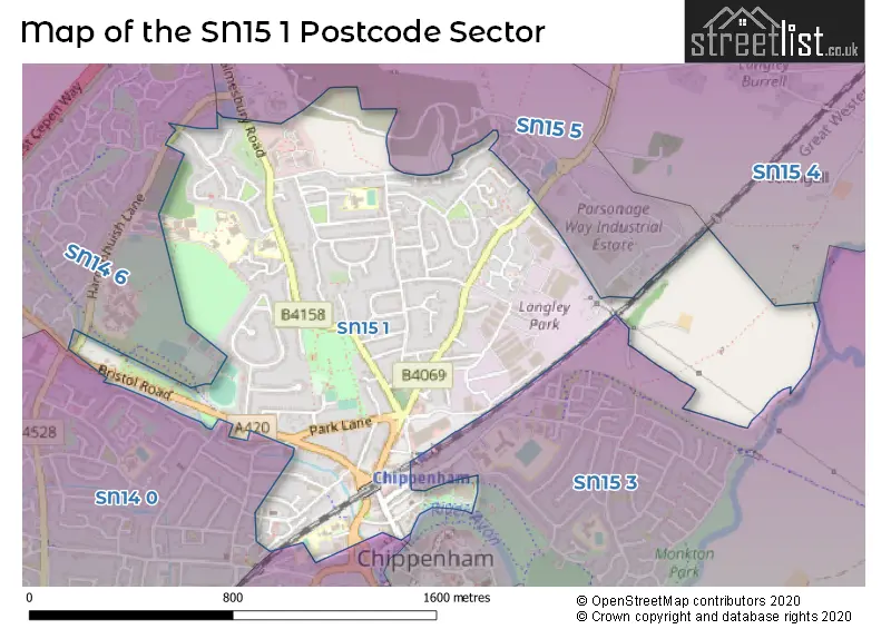
The SN15 1 Postcode shares a border with SN14 0 (CHIPPENHAM, Sheldon), SN14 6 (CHIPPENHAM, Hullavington, Kington St. Michael), SN15 2 (CHIPPENHAM, Bromham, Lacock), SN15 3 (CHIPPENHAM, Pewsham, Monkton Park), SN15 4 (Lyneham, Sutton Benger, Christian Malford) and SN15 5 (Brinkworth, Kington Langley, Great Somerford).
The sector is within the post town of CHIPPENHAM.
SN15 1 is a postcode sector within the SN15 postcode district which is within the SN Swindon postcode area.
The Royal Mail delivery office for the SN15 1 postal sector is the Chippenham Delivery Office.
The area of the SN15 1 postcode sector is 0.92 square miles which is 2.39 square kilometres or 590.11 square acres.
Waterways within the SN15 1 postcode sector include the River Avon.

Map of the SN15 1 Postcode Sector
Explore the SN15 1 postcode sector by using our free interactive map.
| S | N | 1 | 5 | - | 1 | X | X |
| S | N | 1 | 5 | Space | 1 | Letter | Letter |
Official List of Streets
CHIPPENHAM (114 Streets)
Unofficial Streets or Alternative Spellings
Kington Langley
MALMESBURY ROADCHIPPENHAM
AUDLEY ROAD BATH ROAD HARDENHUISH LANE HIGH STREET KINGHAM CLOSE MAUD HEATH COURT PARK AVENUE PROVIDENCE TERRACE THE GARDENS WOODLANDS ROADAllington
BRISTOL ROADWeather Forecast for SN15 1
Press Button to Show Forecast for Chippenham
| Time Period | Icon | Description | Temperature | Rain Probability | Wind |
|---|---|---|---|---|---|
| 12:00 to 15:00 | Cloudy | 11.0°C (feels like 9.0°C) | 5.00% | N 9 mph | |
| 15:00 to 18:00 | Cloudy | 12.0°C (feels like 10.0°C) | 4.00% | N 11 mph | |
| 18:00 to 21:00 | Cloudy | 11.0°C (feels like 9.0°C) | 4.00% | NNE 9 mph | |
| 21:00 to 00:00 | Overcast | 9.0°C (feels like 8.0°C) | 8.00% | N 4 mph |
Press Button to Show Forecast for Chippenham
| Time Period | Icon | Description | Temperature | Rain Probability | Wind |
|---|---|---|---|---|---|
| 00:00 to 03:00 | Overcast | 8.0°C (feels like 7.0°C) | 8.00% | NNE 4 mph | |
| 03:00 to 06:00 | Cloudy | 7.0°C (feels like 6.0°C) | 10.00% | NNW 4 mph | |
| 06:00 to 09:00 | Cloudy | 7.0°C (feels like 6.0°C) | 8.00% | N 4 mph | |
| 09:00 to 12:00 | Cloudy | 8.0°C (feels like 7.0°C) | 6.00% | N 7 mph | |
| 12:00 to 15:00 | Cloudy | 11.0°C (feels like 9.0°C) | 4.00% | N 9 mph | |
| 15:00 to 18:00 | Partly cloudy (day) | 12.0°C (feels like 10.0°C) | 3.00% | N 9 mph | |
| 18:00 to 21:00 | Sunny day | 11.0°C (feels like 10.0°C) | 2.00% | N 7 mph | |
| 21:00 to 00:00 | Clear night | 7.0°C (feels like 6.0°C) | 1.00% | NW 4 mph |
Press Button to Show Forecast for Chippenham
| Time Period | Icon | Description | Temperature | Rain Probability | Wind |
|---|---|---|---|---|---|
| 00:00 to 03:00 | Clear night | 5.0°C (feels like 3.0°C) | 0.00% | NW 4 mph | |
| 03:00 to 06:00 | Clear night | 4.0°C (feels like 2.0°C) | 1.00% | W 4 mph | |
| 06:00 to 09:00 | Partly cloudy (day) | 5.0°C (feels like 3.0°C) | 2.00% | W 4 mph | |
| 09:00 to 12:00 | Partly cloudy (day) | 9.0°C (feels like 8.0°C) | 3.00% | WNW 7 mph | |
| 12:00 to 15:00 | Overcast | 12.0°C (feels like 10.0°C) | 10.00% | WNW 9 mph | |
| 15:00 to 18:00 | Cloudy | 12.0°C (feels like 10.0°C) | 8.00% | WNW 9 mph | |
| 18:00 to 21:00 | Cloudy | 11.0°C (feels like 9.0°C) | 8.00% | NW 7 mph | |
| 21:00 to 00:00 | Cloudy | 8.0°C (feels like 7.0°C) | 7.00% | NNW 4 mph |
Press Button to Show Forecast for Chippenham
| Time Period | Icon | Description | Temperature | Rain Probability | Wind |
|---|---|---|---|---|---|
| 00:00 to 03:00 | Cloudy | 6.0°C (feels like 5.0°C) | 7.00% | N 4 mph | |
| 03:00 to 06:00 | Cloudy | 5.0°C (feels like 4.0°C) | 9.00% | ESE 4 mph | |
| 06:00 to 09:00 | Cloudy | 6.0°C (feels like 4.0°C) | 12.00% | ESE 4 mph | |
| 09:00 to 12:00 | Cloudy | 9.0°C (feels like 7.0°C) | 14.00% | SE 7 mph | |
| 12:00 to 15:00 | Overcast | 11.0°C (feels like 9.0°C) | 24.00% | SSE 9 mph | |
| 15:00 to 18:00 | Cloudy | 11.0°C (feels like 9.0°C) | 17.00% | SSE 9 mph | |
| 18:00 to 21:00 | Cloudy | 10.0°C (feels like 8.0°C) | 21.00% | SE 7 mph | |
| 21:00 to 00:00 | Cloudy | 8.0°C (feels like 6.0°C) | 14.00% | SE 7 mph |
Press Button to Show Forecast for Chippenham
| Time Period | Icon | Description | Temperature | Rain Probability | Wind |
|---|---|---|---|---|---|
| 00:00 to 03:00 | Cloudy | 7.0°C (feels like 5.0°C) | 18.00% | ESE 7 mph | |
| 03:00 to 06:00 | Cloudy | 7.0°C (feels like 4.0°C) | 18.00% | E 7 mph | |
| 06:00 to 09:00 | Cloudy | 7.0°C (feels like 5.0°C) | 18.00% | E 7 mph | |
| 09:00 to 12:00 | Cloudy | 10.0°C (feels like 8.0°C) | 16.00% | E 9 mph | |
| 12:00 to 15:00 | Cloudy | 11.0°C (feels like 9.0°C) | 22.00% | ENE 9 mph | |
| 15:00 to 18:00 | Light rain shower (day) | 12.0°C (feels like 10.0°C) | 36.00% | ESE 9 mph | |
| 18:00 to 21:00 | Cloudy | 11.0°C (feels like 9.0°C) | 20.00% | ENE 9 mph | |
| 21:00 to 00:00 | Light rain | 9.0°C (feels like 7.0°C) | 49.00% | NE 9 mph |
Schools and Places of Education Within the SN15 1 Postcode Sector
Ivy Lane Primary School
Academy converter
Ivy Lane, Chippenham, Wiltshire, SN15 1HE
Head: Mrs Helen Lammin
Ofsted Rating: Good
Inspection: 2022-01-13 (831 days ago)
Website: Visit Ivy Lane Primary School Website
Phone: 01249652556
Number of Pupils: 442
St Paul's Primary School
Community school
The Oaks, Chippenham, Wiltshire, SN15 1DU
Head: Mr Sheridan Upton
Ofsted Rating: Good
Inspection: 2019-06-26 (1763 days ago)
Website: Visit St Paul's Primary School Website
Phone: 01249653041
Number of Pupils: 152
House Prices in the SN15 1 Postcode Sector
| Type of Property | 2018 Average | 2018 Sales | 2017 Average | 2017 Sales | 2016 Average | 2016 Sales | 2015 Average | 2015 Sales |
|---|---|---|---|---|---|---|---|---|
| Detached | £388,777 | 32 | £367,607 | 23 | £407,881 | 21 | £394,563 | 32 |
| Semi-Detached | £268,563 | 54 | £271,561 | 36 | £258,472 | 39 | £216,611 | 35 |
| Terraced | £225,802 | 37 | £231,652 | 29 | £216,517 | 22 | £182,976 | 31 |
| Flats | £174,717 | 12 | £130,346 | 23 | £120,212 | 13 | £116,519 | 21 |
Important Postcodes SN15 1 in the Postcode Sector
SN15 1BN is the postcode for Crown Prosecution Service, Unit 4, Greenways Business Park, Bellinger Close
SN15 1BW is the postcode for H M Revenue & Customs, Kilvert House, 6 Greenways Business Park, Bellinger Close
SN15 1DU is the postcode for St. Pauls Primary School, The Oaks
SN15 1ER is the postcode for Wiltshire Council, Monkton Park Offices, and Wiltshire Council, Monkton Park
SN15 1GG is the postcode for Avon Gloucestershire & Wiltshire Strategic Health Authority, Unit E3, Langley Park, Avon Way
SN15 1HE is the postcode for HEDRA, Ivy Lane Primary School, Ivy Road, EARLY YEARS BUILDING, Ivy Lane School, Ivy Lane, Ivy Lane Primary School, Ivy Road, and MAIN BUILDING, Ivy Lane Primary School, Ivy Road
SN15 1HP is the postcode for Hathaway Surgery, 32 New Road
SN15 1JT is the postcode for 34, Marshfield Road
SN15 1LA is the postcode for St. Pauls House, 1 Marshfield Road
SN15 1LE is the postcode for Wiltshire Fire Brigade, Fire Station, Dallas Road
SN15 1QF is the postcode for St. Nicholas School, Malmesbury Road
| The SN15 1 Sector is within these Local Authorities |
|
|---|---|
| The SN15 1 Sector is within these Counties |
|
| The SN15 1 Sector is within these Water Company Areas |
|