The SN25 1 postcode sector is within the county of Wiltshire.
Did you know? According to the 2021 Census, the SN25 1 postcode sector is home to a bustling 10,358 residents!
Given that each sector allows for 400 unique postcode combinations. Letters C, I, K, M, O and V are not allowed in the last two letters of a postcode. With 173 postcodes already in use, this leaves 227 units available.
The largest settlements in the SN25 1 postal code are SWINDON and Haydon Wick.
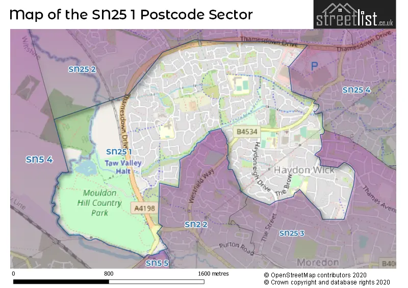
The SN25 1 Postcode shares a border with SN5 4 (Purton, Purton Stoke), SN5 5 (Shaw, Peatmoor, Middleleaze), SN25 3 (SWINDON), SN25 4 (SWINDON), SN2 2 (SWINDON, Cheney Manor Industrial Estate) and SN25 2 (SWINDON, Tadpole Garden Village, Blunsdon).
The sector is within the post town of SWINDON.
SN25 1 is a postcode sector within the SN25 postcode district which is within the SN Swindon postcode area.
The Royal Mail delivery office for the SN25 1 postal sector is the Hawksworth Delivery Office.
The area of the SN25 1 postcode sector is 1.00 square miles which is 2.60 square kilometres or 641.62 square acres.
Waterways within the SN25 1 postcode sector include the River Ray.

Map of the SN25 1 Postcode Sector
Explore the SN25 1 postcode sector by using our free interactive map.
| S | N | 2 | 5 | - | 1 | X | X |
| S | N | 2 | 5 | Space | 1 | Letter | Letter |
Official List of Streets
SWINDON (118 Streets)
Haydon Wick (1 Streets)
Unofficial Streets or Alternative Spellings
SWINDON
AVONMEAD EASTBURY WAY MEDWAY ROAD OAKHURST WAY POND STREET THE STREET BORDER CLOSE CHARMIND WALK CHOPIN MEWS CRANBOURNE CHASE DISTRICT CENTRE GRACE WALK GREENWOOD COURT LADY LANE MILBURY WALK OLD PURTON ROAD ROSE WALK TADPOLE BROOK TAW HILL THAMESDOWN DRIVE THE CHESTNUTS WESTFIELD WAY WOODLAND COURTPurton
PURTON ROADWeather Forecast for SN25 1
Press Button to Show Forecast for Cricklade
| Time Period | Icon | Description | Temperature | Rain Probability | Wind |
|---|---|---|---|---|---|
| 03:00 to 06:00 | Cloudy | 5.0°C (feels like 3.0°C) | 4.00% | W 4 mph | |
| 06:00 to 09:00 | Partly cloudy (day) | 4.0°C (feels like 2.0°C) | 6.00% | W 4 mph | |
| 09:00 to 12:00 | Cloudy | 8.0°C (feels like 6.0°C) | 14.00% | W 9 mph | |
| 12:00 to 15:00 | Overcast | 11.0°C (feels like 8.0°C) | 11.00% | W 11 mph | |
| 15:00 to 18:00 | Cloudy | 11.0°C (feels like 9.0°C) | 5.00% | WNW 9 mph | |
| 18:00 to 21:00 | Cloudy | 9.0°C (feels like 7.0°C) | 7.00% | NNE 7 mph | |
| 21:00 to 00:00 | Cloudy | 7.0°C (feels like 5.0°C) | 6.00% | ENE 4 mph |
Press Button to Show Forecast for Cricklade
| Time Period | Icon | Description | Temperature | Rain Probability | Wind |
|---|---|---|---|---|---|
| 00:00 to 03:00 | Cloudy | 6.0°C (feels like 4.0°C) | 5.00% | ENE 7 mph | |
| 03:00 to 06:00 | Cloudy | 5.0°C (feels like 2.0°C) | 5.00% | ENE 7 mph | |
| 06:00 to 09:00 | Cloudy | 4.0°C (feels like 1.0°C) | 6.00% | ENE 7 mph | |
| 09:00 to 12:00 | Cloudy | 7.0°C (feels like 5.0°C) | 7.00% | ENE 9 mph | |
| 12:00 to 15:00 | Overcast | 10.0°C (feels like 8.0°C) | 13.00% | ENE 7 mph | |
| 15:00 to 18:00 | Overcast | 10.0°C (feels like 9.0°C) | 16.00% | ENE 7 mph | |
| 18:00 to 21:00 | Cloudy | 9.0°C (feels like 8.0°C) | 14.00% | ENE 7 mph | |
| 21:00 to 00:00 | Cloudy | 7.0°C (feels like 4.0°C) | 13.00% | ENE 7 mph |
Press Button to Show Forecast for Cricklade
| Time Period | Icon | Description | Temperature | Rain Probability | Wind |
|---|---|---|---|---|---|
| 00:00 to 03:00 | Cloudy | 5.0°C (feels like 2.0°C) | 14.00% | ENE 7 mph | |
| 03:00 to 06:00 | Overcast | 4.0°C (feels like 2.0°C) | 16.00% | ENE 7 mph | |
| 06:00 to 09:00 | Cloudy | 5.0°C (feels like 2.0°C) | 20.00% | NE 9 mph | |
| 09:00 to 12:00 | Light rain | 7.0°C (feels like 5.0°C) | 49.00% | ENE 9 mph | |
| 12:00 to 15:00 | Overcast | 10.0°C (feels like 7.0°C) | 22.00% | ENE 11 mph | |
| 15:00 to 18:00 | Overcast | 11.0°C (feels like 9.0°C) | 21.00% | ENE 11 mph | |
| 18:00 to 21:00 | Cloudy | 10.0°C (feels like 8.0°C) | 23.00% | NE 11 mph | |
| 21:00 to 00:00 | Light rain | 8.0°C (feels like 5.0°C) | 52.00% | NE 13 mph |
Press Button to Show Forecast for Cricklade
| Time Period | Icon | Description | Temperature | Rain Probability | Wind |
|---|---|---|---|---|---|
| 00:00 to 03:00 | Light rain | 7.0°C (feels like 4.0°C) | 52.00% | NE 13 mph | |
| 03:00 to 06:00 | Heavy rain | 7.0°C (feels like 4.0°C) | 73.00% | NE 11 mph | |
| 06:00 to 09:00 | Heavy rain | 7.0°C (feels like 5.0°C) | 74.00% | NE 9 mph | |
| 09:00 to 12:00 | Light rain | 9.0°C (feels like 7.0°C) | 49.00% | ENE 9 mph | |
| 12:00 to 15:00 | Light rain shower (day) | 10.0°C (feels like 8.0°C) | 40.00% | WNW 11 mph | |
| 15:00 to 18:00 | Light rain shower (day) | 10.0°C (feels like 7.0°C) | 42.00% | WNW 11 mph | |
| 18:00 to 21:00 | Light rain shower (day) | 10.0°C (feels like 8.0°C) | 34.00% | WNW 9 mph | |
| 21:00 to 00:00 | Partly cloudy (night) | 8.0°C (feels like 6.0°C) | 6.00% | NW 7 mph |
Schools and Places of Education Within the SN25 1 Postcode Sector
Haydonleigh Primary School
Community school
Haydon Court Drive, Swindon, Wiltshire, SN25 1JP
Head: Mrs Frances Billinge
Ofsted Rating: Good
Inspection: 2019-01-22 (1920 days ago)
Website: Visit Haydonleigh Primary School Website
Phone: 01793700443
Number of Pupils: 596
Orchid Vale Primary School
Academy sponsor led
Torun Way, Swindon, Wiltshire, SN25 1UG
Head: Mrs Ruth Lee
Ofsted Rating: Good
Inspection: 2023-09-13 (225 days ago)
Website: Visit Orchid Vale Primary School Website
Phone: 01793745006
Number of Pupils: 415
St Francis CofE Primary School
Voluntary aided school
Aiken Road, Swindon, Wiltshire, SN25 1UH
Head: Mrs Hester Millsop
Ofsted Rating: Outstanding
Inspection: 2012-03-15 (4424 days ago)
Website: Visit St Francis CofE Primary School Website
Phone: 01793727624
Number of Pupils: 451
House Prices in the SN25 1 Postcode Sector
| Type of Property | 2018 Average | 2018 Sales | 2017 Average | 2017 Sales | 2016 Average | 2016 Sales | 2015 Average | 2015 Sales |
|---|---|---|---|---|---|---|---|---|
| Detached | £292,976 | 62 | £312,761 | 80 | £298,039 | 58 | £280,324 | 65 |
| Semi-Detached | £270,108 | 28 | £234,707 | 57 | £220,443 | 40 | £210,097 | 29 |
| Terraced | £221,217 | 61 | £225,795 | 65 | £208,470 | 90 | £187,338 | 119 |
| Flats | £131,444 | 63 | £143,727 | 48 | £126,576 | 78 | £117,008 | 79 |
Important Postcodes SN25 1 in the Postcode Sector
SN25 1HT is the postcode for Haydon Wick Primary School, The Brow
SN25 1JP is the postcode for Haydonleigh School, Haydon Court Drive, and Haydonleigh Primary School, Haydon Court Drive, Haydon Wick
SN25 1QQ is the postcode for North Swindon Practice, Thames Avenue, HAYDON WICK COMMUNITY LEISURE CENTRE, THAMES AVENUE, HAYDON WICK, and Haydon Wick Community Leisure Centre, Thames Avenue
SN25 1RY is the postcode for Fessey House, Brookdene
SN25 1UG is the postcode for Orchid Way Primary School, Torun Way, and Orchid Vale Primary School, Torun Way, Haydon End
SN25 1UH is the postcode for Taw Hill Medical Centre, Taw Hill Village Centre, PART, Taw Hill Medical Centre, Aiken Road, and St. Francis C of E Primary School, Aiken Road
| The SN25 1 Sector is within these Local Authorities |
|
|---|---|
| The SN25 1 Sector is within these Counties |
|
| The SN25 1 Sector is within these Water Company Areas |
|