The SN26 7 postcode sector is within the county of Wiltshire.
Did you know? According to the 2021 Census, the SN26 7 postcode sector is home to a bustling 1,640 residents!
Given that each sector allows for 400 unique postcode combinations. Letters C, I, K, M, O and V are not allowed in the last two letters of a postcode. With 37 postcodes already in use, this leaves 363 units available.
The SN26 7 postal code covers the settlement of Blunsdon.
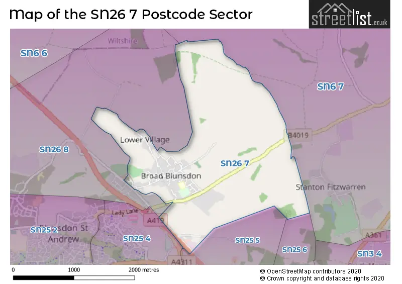
The SN26 7 Postcode shares a border with SN26 8 (Blunsdon), SN6 7 (Highworth, Hannington, Coleshill), SN25 4 (SWINDON), SN25 5 (Groundwell Industrial Estate, Blunsdon, SWINDON) and SN25 6 (SWINDON).
The sector is within the post town of SWINDON.
SN26 7 is a postcode sector within the SN26 postcode district which is within the SN Swindon postcode area.
The Royal Mail delivery office for the SN26 7 postal sector is the Hawksworth Delivery Office.
The area of the SN26 7 postcode sector is 2.29 square miles which is 5.92 square kilometres or 1,462.50 square acres.
The SN26 7 postcode sector is crossed by the A419 Major A road.

Map of the SN26 7 Postcode Sector
Explore the SN26 7 postcode sector by using our free interactive map.
| S | N | 2 | 6 | - | 7 | X | X |
| S | N | 2 | 6 | Space | 7 | Letter | Letter |
Official List of Streets
Blunsdon (37 Streets)
Unofficial Streets or Alternative Spellings
Weather Forecast for SN26 7
Press Button to Show Forecast for Highworth
| Time Period | Icon | Description | Temperature | Rain Probability | Wind |
|---|---|---|---|---|---|
| 00:00 to 03:00 | Cloudy | 6.0°C (feels like 4.0°C) | 4.00% | SSW 4 mph | |
| 03:00 to 06:00 | Cloudy | 5.0°C (feels like 3.0°C) | 4.00% | WSW 4 mph | |
| 06:00 to 09:00 | Partly cloudy (day) | 4.0°C (feels like 2.0°C) | 3.00% | W 7 mph | |
| 09:00 to 12:00 | Cloudy | 8.0°C (feels like 5.0°C) | 15.00% | W 9 mph | |
| 12:00 to 15:00 | Overcast | 10.0°C (feels like 7.0°C) | 11.00% | W 11 mph | |
| 15:00 to 18:00 | Cloudy | 11.0°C (feels like 9.0°C) | 7.00% | WNW 7 mph | |
| 18:00 to 21:00 | Cloudy | 9.0°C (feels like 7.0°C) | 7.00% | NNE 7 mph | |
| 21:00 to 00:00 | Cloudy | 6.0°C (feels like 4.0°C) | 5.00% | ENE 7 mph |
Press Button to Show Forecast for Highworth
| Time Period | Icon | Description | Temperature | Rain Probability | Wind |
|---|---|---|---|---|---|
| 00:00 to 03:00 | Cloudy | 5.0°C (feels like 3.0°C) | 5.00% | ENE 7 mph | |
| 03:00 to 06:00 | Cloudy | 4.0°C (feels like 2.0°C) | 5.00% | ENE 7 mph | |
| 06:00 to 09:00 | Cloudy | 4.0°C (feels like 1.0°C) | 6.00% | ENE 7 mph | |
| 09:00 to 12:00 | Cloudy | 7.0°C (feels like 4.0°C) | 7.00% | ENE 9 mph | |
| 12:00 to 15:00 | Overcast | 9.0°C (feels like 8.0°C) | 13.00% | ENE 7 mph | |
| 15:00 to 18:00 | Overcast | 10.0°C (feels like 8.0°C) | 16.00% | ENE 7 mph | |
| 18:00 to 21:00 | Cloudy | 9.0°C (feels like 8.0°C) | 14.00% | ENE 7 mph | |
| 21:00 to 00:00 | Cloudy | 6.0°C (feels like 4.0°C) | 13.00% | ENE 7 mph |
Press Button to Show Forecast for Highworth
| Time Period | Icon | Description | Temperature | Rain Probability | Wind |
|---|---|---|---|---|---|
| 00:00 to 03:00 | Cloudy | 5.0°C (feels like 2.0°C) | 14.00% | ENE 7 mph | |
| 03:00 to 06:00 | Overcast | 4.0°C (feels like 1.0°C) | 16.00% | ENE 7 mph | |
| 06:00 to 09:00 | Overcast | 4.0°C (feels like 1.0°C) | 21.00% | NE 9 mph | |
| 09:00 to 12:00 | Light rain | 7.0°C (feels like 4.0°C) | 49.00% | ENE 9 mph | |
| 12:00 to 15:00 | Overcast | 10.0°C (feels like 7.0°C) | 22.00% | ENE 11 mph | |
| 15:00 to 18:00 | Overcast | 11.0°C (feels like 9.0°C) | 21.00% | ENE 11 mph | |
| 18:00 to 21:00 | Cloudy | 10.0°C (feels like 7.0°C) | 23.00% | NE 11 mph | |
| 21:00 to 00:00 | Light rain | 8.0°C (feels like 5.0°C) | 52.00% | NE 13 mph |
Press Button to Show Forecast for Highworth
| Time Period | Icon | Description | Temperature | Rain Probability | Wind |
|---|---|---|---|---|---|
| 00:00 to 03:00 | Light rain | 7.0°C (feels like 4.0°C) | 52.00% | NE 13 mph | |
| 03:00 to 06:00 | Heavy rain | 7.0°C (feels like 4.0°C) | 73.00% | NE 11 mph | |
| 06:00 to 09:00 | Heavy rain | 7.0°C (feels like 4.0°C) | 74.00% | NE 9 mph | |
| 09:00 to 12:00 | Light rain | 9.0°C (feels like 6.0°C) | 49.00% | ENE 9 mph | |
| 12:00 to 15:00 | Light rain shower (day) | 10.0°C (feels like 7.0°C) | 40.00% | WNW 11 mph | |
| 15:00 to 18:00 | Light rain shower (day) | 10.0°C (feels like 7.0°C) | 42.00% | WNW 11 mph | |
| 18:00 to 21:00 | Light rain shower (day) | 9.0°C (feels like 7.0°C) | 36.00% | WNW 9 mph | |
| 21:00 to 00:00 | Partly cloudy (night) | 7.0°C (feels like 6.0°C) | 6.00% | NW 7 mph |
House Prices in the SN26 7 Postcode Sector
| Type of Property | 2018 Average | 2018 Sales | 2017 Average | 2017 Sales | 2016 Average | 2016 Sales | 2015 Average | 2015 Sales |
|---|---|---|---|---|---|---|---|---|
| Detached | £407,585 | 24 | £466,767 | 15 | £444,785 | 15 | £336,938 | 8 |
| Semi-Detached | £289,114 | 7 | £341,000 | 3 | £241,500 | 3 | £264,167 | 3 |
| Terraced | £227,380 | 5 | £418,000 | 1 | £231,000 | 2 | £342,921 | 7 |
| Flats | £0 | 0 | £0 | 0 | £0 | 0 | £127,500 | 1 |
Important Postcodes SN26 7 in the Postcode Sector
SN26 7AP is the postcode for St Leonard?s CE Primary Academy, Linley Road, and ST LEONARDS CE PRIMARY SCHOOL, LINLEY ROAD, BLUNSDON
| The SN26 7 Sector is within these Local Authorities |
|
|---|---|
| The SN26 7 Sector is within these Counties |
|
| The SN26 7 Sector is within these Water Company Areas |
|