The SO16 4 postcode sector is within the county of Hampshire.
Did you know? According to the 2021 Census, the SO16 4 postcode sector is home to a bustling 8,631 residents!
Given that each sector allows for 400 unique postcode combinations. Letters C, I, K, M, O and V are not allowed in the last two letters of a postcode. With 202 postcodes already in use, this leaves 198 units available.
The SO16 4 postal code covers the settlement of SOUTHAMPTON.
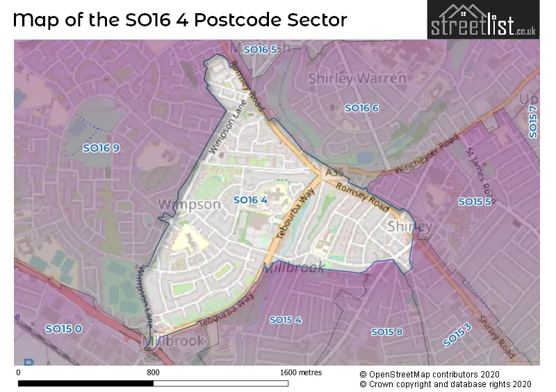
The SO16 4 Postcode shares a border with SO15 0 (SOUTHAMPTON, Western Docks), SO15 5 (SOUTHAMPTON), SO16 6 (SOUTHAMPTON), SO15 3 (SOUTHAMPTON), SO15 4 (SOUTHAMPTON), SO15 8 (SOUTHAMPTON) and SO16 9 (SOUTHAMPTON).
The sector is within the post town of SOUTHAMPTON.
SO16 4 is a postcode sector within the SO16 postcode district which is within the SO Southampton postcode area.
The Royal Mail delivery office for the SO16 4 postal sector is the Shirley (so) Delivery Office.
The area of the SO16 4 postcode sector is 0.47 square miles which is 1.22 square kilometres or 302.37 square acres.
Waterways within the SO16 4 postcode sector include the Tanners Brook.

Map of the SO16 4 Postcode Sector
Explore the SO16 4 postcode sector by using our free interactive map.
| S | O | 1 | 6 | - | 4 | X | X |
| S | O | 1 | 6 | Space | 4 | Letter | Letter |
Official List of Streets
SOUTHAMPTON (64 Streets)
Unofficial Streets or Alternative Spellings
SOUTHAMPTON
ANGLESEA ROAD ARLISS ROAD AUCKLAND ROAD BROOK VALLEY COLBY STREET CRABWOOD ROAD GRANGE ROAD GREEN PARK ROAD KENDAL AVENUE MANSEL ROAD EAST MARLBOROUGH ROAD MAYBUSH ROAD MILLBROOK ROAD WEST PRINCE OF WALES AVENUE REDCAR STREET REGENTS PARK ROAD ROWNHAMS ROAD SEVERN ROAD SYDNEY ROAD WATERHOUSE LANE WILROY GARDENS WIMPSON GARDENS WINCHESTER ROAD WINDERMERE AVENUE WINSTON CLOSE JESS CLARK LODGE KING GEORGES AVENUE MILLBROOK FLYOVER MILLBROOK ROUNDABOUT REGENTS GROVE SHINEWILL GARDENS THE MOUNTNursling
ROMSEY ROADWeather Forecast for SO16 4
Press Button to Show Forecast for Millbrook (Southampton)
| Time Period | Icon | Description | Temperature | Rain Probability | Wind |
|---|---|---|---|---|---|
| 09:00 to 12:00 | Cloudy | 11.0°C (feels like 8.0°C) | 4.00% | NW 16 mph | |
| 12:00 to 15:00 | Sunny day | 13.0°C (feels like 9.0°C) | 4.00% | NW 16 mph | |
| 15:00 to 18:00 | Partly cloudy (day) | 13.0°C (feels like 10.0°C) | 4.00% | NNW 16 mph | |
| 18:00 to 21:00 | Sunny day | 11.0°C (feels like 8.0°C) | 1.00% | NNW 11 mph | |
| 21:00 to 00:00 | Clear night | 8.0°C (feels like 6.0°C) | 0.00% | NW 7 mph |
Press Button to Show Forecast for Millbrook (Southampton)
| Time Period | Icon | Description | Temperature | Rain Probability | Wind |
|---|---|---|---|---|---|
| 00:00 to 03:00 | Clear night | 6.0°C (feels like 4.0°C) | 2.00% | NW 7 mph | |
| 03:00 to 06:00 | Partly cloudy (night) | 6.0°C (feels like 3.0°C) | 2.00% | WNW 9 mph | |
| 06:00 to 09:00 | Sunny day | 6.0°C (feels like 3.0°C) | 3.00% | NW 9 mph | |
| 09:00 to 12:00 | Cloudy | 8.0°C (feels like 5.0°C) | 5.00% | NNW 16 mph | |
| 12:00 to 15:00 | Cloudy | 10.0°C (feels like 8.0°C) | 9.00% | NNW 13 mph | |
| 15:00 to 18:00 | Overcast | 11.0°C (feels like 8.0°C) | 11.00% | NW 13 mph | |
| 18:00 to 21:00 | Partly cloudy (day) | 9.0°C (feels like 7.0°C) | 5.00% | NW 11 mph | |
| 21:00 to 00:00 | Partly cloudy (night) | 7.0°C (feels like 5.0°C) | 3.00% | NW 9 mph |
Press Button to Show Forecast for Millbrook (Southampton)
| Time Period | Icon | Description | Temperature | Rain Probability | Wind |
|---|---|---|---|---|---|
| 00:00 to 03:00 | Clear night | 6.0°C (feels like 3.0°C) | 2.00% | NNW 9 mph | |
| 03:00 to 06:00 | Partly cloudy (night) | 5.0°C (feels like 2.0°C) | 3.00% | NNW 9 mph | |
| 06:00 to 09:00 | Sunny day | 5.0°C (feels like 2.0°C) | 4.00% | N 7 mph | |
| 09:00 to 12:00 | Sunny day | 9.0°C (feels like 7.0°C) | 3.00% | N 7 mph | |
| 12:00 to 15:00 | Cloudy | 11.0°C (feels like 10.0°C) | 6.00% | N 4 mph | |
| 15:00 to 18:00 | Cloudy | 12.0°C (feels like 10.0°C) | 7.00% | W 9 mph | |
| 18:00 to 21:00 | Partly cloudy (day) | 11.0°C (feels like 8.0°C) | 3.00% | W 11 mph | |
| 21:00 to 00:00 | Partly cloudy (night) | 9.0°C (feels like 6.0°C) | 2.00% | W 9 mph |
Press Button to Show Forecast for Millbrook (Southampton)
| Time Period | Icon | Description | Temperature | Rain Probability | Wind |
|---|---|---|---|---|---|
| 00:00 to 03:00 | Cloudy | 8.0°C (feels like 6.0°C) | 8.00% | W 9 mph | |
| 03:00 to 06:00 | Clear night | 8.0°C (feels like 5.0°C) | 3.00% | W 9 mph | |
| 06:00 to 09:00 | Cloudy | 8.0°C (feels like 5.0°C) | 6.00% | W 11 mph | |
| 09:00 to 12:00 | Cloudy | 11.0°C (feels like 8.0°C) | 5.00% | WNW 13 mph | |
| 12:00 to 15:00 | Overcast | 13.0°C (feels like 10.0°C) | 10.00% | NW 16 mph | |
| 15:00 to 18:00 | Cloudy | 14.0°C (feels like 11.0°C) | 5.00% | NW 16 mph | |
| 18:00 to 21:00 | Partly cloudy (day) | 13.0°C (feels like 11.0°C) | 1.00% | NW 11 mph | |
| 21:00 to 00:00 | Clear night | 10.0°C (feels like 8.0°C) | 1.00% | NNW 9 mph |
Schools and Places of Education Within the SO16 4 Postcode Sector
Mason Moor Primary School
Community school
Helvellyn Road, Southampton, Hampshire, SO16 4AS
Head: Mr Daniel Constable-Phelps
Ofsted Rating: Requires improvement
Inspection: 2023-06-28 (293 days ago)
Website: Visit Mason Moor Primary School Website
Phone: 02380390140
Number of Pupils: 204
Regents Park Community College
Foundation school
King Edward Avenue, Southampton, Hampshire, SO16 4GW
Head: Mrs Samantha Barnes
Ofsted Rating: Good
Inspection: 2018-11-15 (1979 days ago)
Website: Visit Regents Park Community College Website
Phone: 02380325444
Number of Pupils: 899
House Prices in the SO16 4 Postcode Sector
| Type of Property | 2018 Average | 2018 Sales | 2017 Average | 2017 Sales | 2016 Average | 2016 Sales | 2015 Average | 2015 Sales |
|---|---|---|---|---|---|---|---|---|
| Detached | £2,025,905 | 7 | £226,000 | 5 | £279,500 | 4 | £281,375 | 4 |
| Semi-Detached | £232,860 | 35 | £223,674 | 40 | £260,712 | 34 | £217,438 | 28 |
| Terraced | £211,855 | 30 | £224,302 | 64 | £205,518 | 47 | £203,249 | 66 |
| Flats | £138,363 | 31 | £143,275 | 53 | £158,012 | 38 | £120,367 | 55 |
Important Postcodes SO16 4 in the Postcode Sector
SO16 4AS is the postcode for Mason Moor Primary School, Helvellyn Road, and MASON MOOR PRIMARY SCHOOL, HELVELLYN ROAD, SOUTHAMPTON
SO16 4GU is the postcode for Ordnance Survey, Romsey Road
SO16 4GW is the postcode for Regents Park Community College, King Edward Avenue, SOUTH BLOCK, Regents Park Community College, King Edward Avenue, B BLOCK, Regents Park Community College, King Edward Avenue, and MAIN BUILDING, Regents Park Community College, King Edward Avenue
SO16 4GX is the postcode for NHS Commissioning Building, Oakley Road
SO16 4HP is the postcode for H M Revenue & Customs, Compass House, Romsey Road
SO16 4LZ is the postcode for Redbridge Hill Fire Station, Redbridge Hill
SO16 4NZ is the postcode for Brook House Surgery, 98 Oakley Road
SO16 4PS is the postcode for Woodside Lodge, Wimpson Lane
SO16 4XE is the postcode for Trust Taplins Childcare Centre, Western Community Hospital, William Macleod Way, Adelaide Health Centre, William MacLeod Way, Adelaide Health Centre, Western Community Hospital, William Macleod Way, and Western Community Hospital, Walnut Grove
| The SO16 4 Sector is within these Local Authorities |
|
|---|---|
| The SO16 4 Sector is within these Counties |
|
| The SO16 4 Sector is within these Water Company Areas |
|