The SO19 6 postcode sector is within the county of Hampshire.
Did you know? According to the 2021 Census, the SO19 6 postcode sector is home to a bustling 9,243 residents!
Given that each sector allows for 400 unique postcode combinations. Letters C, I, K, M, O and V are not allowed in the last two letters of a postcode. With 242 postcodes already in use, this leaves 158 units available.
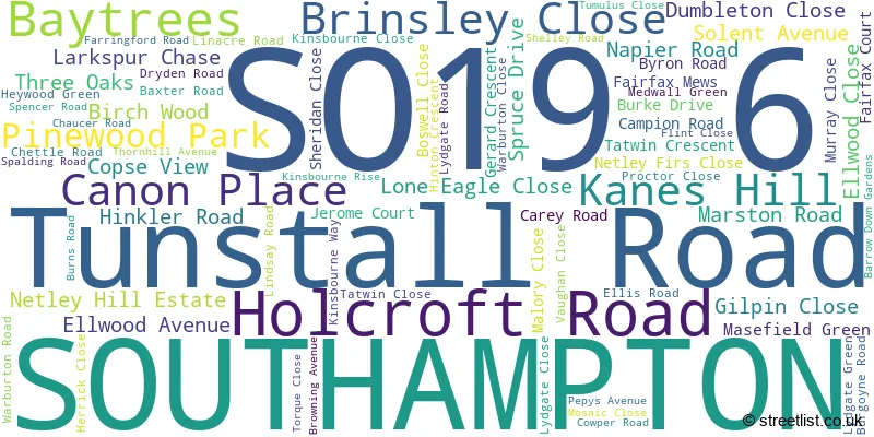
The SO19 6 postal code covers the settlement of SOUTHAMPTON.
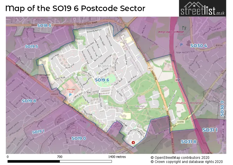
The SO19 6 Postcode shares a border with SO19 0 (SOUTHAMPTON), SO19 1 (SOUTHAMPTON), SO18 5 (SOUTHAMPTON), SO19 8 (SOUTHAMPTON), SO30 3 (West End), SO30 4 (Hedge End), SO19 5 (SOUTHAMPTON), SO31 1 (Park Gate, Bursledon, Burridge) and SO31 8 (Bursledon).
The sector is within the post town of SOUTHAMPTON.
SO19 6 is a postcode sector within the SO19 postcode district which is within the SO Southampton postcode area.
The Royal Mail delivery office for the SO19 6 postal sector is the Bitterne Manor.
The area of the SO19 6 postcode sector is 0.76 square miles which is 1.97 square kilometres or 487.28 square acres.
The SO19 6 postcode sector is crossed by the M27 motorway.

Map of the SO19 6 Postcode Sector
Explore the SO19 6 postcode sector by using our free interactive map.
| S | O | 1 | 9 | - | 6 | X | X |
| S | O | 1 | 9 | Space | 6 | Letter | Letter |
Official List of Streets
SOUTHAMPTON (74 Streets)
Unofficial Streets or Alternative Spellings
Weather Forecast for SO19 6
Press Button to Show Forecast for Thornhill (Southampton)
| Time Period | Icon | Description | Temperature | Rain Probability | Wind |
|---|---|---|---|---|---|
| 03:00 to 06:00 | Cloudy | 9.0°C (feels like 6.0°C) | 5.00% | W 11 mph | |
| 06:00 to 09:00 | Cloudy | 10.0°C (feels like 7.0°C) | 7.00% | WNW 11 mph | |
| 09:00 to 12:00 | Cloudy | 12.0°C (feels like 9.0°C) | 13.00% | NW 16 mph | |
| 12:00 to 15:00 | Overcast | 12.0°C (feels like 9.0°C) | 11.00% | NW 16 mph | |
| 15:00 to 18:00 | Cloudy | 13.0°C (feels like 10.0°C) | 4.00% | NNW 16 mph | |
| 18:00 to 21:00 | Partly cloudy (day) | 12.0°C (feels like 9.0°C) | 1.00% | N 11 mph | |
| 21:00 to 00:00 | Cloudy | 9.0°C (feels like 7.0°C) | 5.00% | N 9 mph |
Press Button to Show Forecast for Thornhill (Southampton)
| Time Period | Icon | Description | Temperature | Rain Probability | Wind |
|---|---|---|---|---|---|
| 00:00 to 03:00 | Cloudy | 7.0°C (feels like 6.0°C) | 3.00% | NNE 7 mph | |
| 03:00 to 06:00 | Cloudy | 5.0°C (feels like 3.0°C) | 4.00% | N 7 mph | |
| 06:00 to 09:00 | Sunny day | 5.0°C (feels like 2.0°C) | 2.00% | N 7 mph | |
| 09:00 to 12:00 | Partly cloudy (day) | 8.0°C (feels like 5.0°C) | 2.00% | NNE 9 mph | |
| 12:00 to 15:00 | Overcast | 10.0°C (feels like 8.0°C) | 7.00% | N 11 mph | |
| 15:00 to 18:00 | Overcast | 11.0°C (feels like 9.0°C) | 8.00% | NNE 9 mph | |
| 18:00 to 21:00 | Overcast | 10.0°C (feels like 8.0°C) | 8.00% | NNE 9 mph | |
| 21:00 to 00:00 | Overcast | 8.0°C (feels like 6.0°C) | 8.00% | NNE 4 mph |
Press Button to Show Forecast for Thornhill (Southampton)
| Time Period | Icon | Description | Temperature | Rain Probability | Wind |
|---|---|---|---|---|---|
| 00:00 to 03:00 | Cloudy | 6.0°C (feels like 5.0°C) | 5.00% | NNE 4 mph | |
| 03:00 to 06:00 | Partly cloudy (night) | 5.0°C (feels like 3.0°C) | 2.00% | N 4 mph | |
| 06:00 to 09:00 | Partly cloudy (day) | 6.0°C (feels like 4.0°C) | 2.00% | N 4 mph | |
| 09:00 to 12:00 | Cloudy | 9.0°C (feels like 7.0°C) | 5.00% | NNE 9 mph | |
| 12:00 to 15:00 | Cloudy | 11.0°C (feels like 9.0°C) | 6.00% | NNE 9 mph | |
| 15:00 to 18:00 | Overcast | 11.0°C (feels like 9.0°C) | 11.00% | NNE 9 mph | |
| 18:00 to 21:00 | Cloudy | 11.0°C (feels like 9.0°C) | 6.00% | NNE 9 mph | |
| 21:00 to 00:00 | Clear night | 8.0°C (feels like 6.0°C) | 3.00% | NNE 9 mph |
Press Button to Show Forecast for Thornhill (Southampton)
| Time Period | Icon | Description | Temperature | Rain Probability | Wind |
|---|---|---|---|---|---|
| 00:00 to 03:00 | Partly cloudy (night) | 7.0°C (feels like 4.0°C) | 3.00% | NE 7 mph | |
| 03:00 to 06:00 | Partly cloudy (night) | 5.0°C (feels like 3.0°C) | 2.00% | NNE 7 mph | |
| 06:00 to 09:00 | Sunny day | 5.0°C (feels like 2.0°C) | 2.00% | NNE 9 mph | |
| 09:00 to 12:00 | Cloudy | 9.0°C (feels like 6.0°C) | 4.00% | NE 11 mph | |
| 12:00 to 15:00 | Cloudy | 11.0°C (feels like 9.0°C) | 7.00% | NE 11 mph | |
| 15:00 to 18:00 | Cloudy | 12.0°C (feels like 9.0°C) | 9.00% | NE 11 mph | |
| 18:00 to 21:00 | Cloudy | 10.0°C (feels like 8.0°C) | 8.00% | NE 9 mph | |
| 21:00 to 00:00 | Partly cloudy (night) | 8.0°C (feels like 6.0°C) | 3.00% | NE 7 mph |
Schools and Places of Education Within the SO19 6 Postcode Sector
Hightown Primary School
Academy sponsor led
Tunstall Road, Southampton, Hampshire, SO19 6AA
Head: Miss Hayley Clark
Ofsted Rating: Good
Inspection: 2023-11-08 (163 days ago)
Website: Visit Hightown Primary School Website
Phone: 02380403536
Number of Pupils: 180
Kanes Hill Primary School
Academy converter
Fairfax Court, Southampton, Hampshire, SO19 6FW
Head: Mrs Lisa Marshall
Ofsted Rating: Good
Inspection: 2022-12-07 (499 days ago)
Website: Visit Kanes Hill Primary School Website
Phone: 02380463737
Number of Pupils: 393
Springwell School
Community special school
Hinkler Road, Southampton, Hampshire, SO19 6DH
Head: Co Headteacher Lisa Needham Maria Burrows
Ofsted Rating: Outstanding
Inspection: 2023-06-28 (296 days ago)
Website: Visit Springwell School Website
Phone: 02380445981
Number of Pupils: 271
The Serendipity School
Other independent special school
399 Hinkler Road, Southampton, Hampshire, SO19 6DS
Head: Miss Philippa Smith
Ofsted Rating: Outstanding
Inspection: 2021-07-15 (1009 days ago)
Website: Visit The Serendipity School Website
Phone: 02380422255
Number of Pupils: 18
Thornhill Primary School
Academy converter
Byron Road, Southampton, Hampshire, SO19 6FH
Head: Mrs L Carroll
Ofsted Rating: Requires improvement
Inspection: 2023-06-28 (296 days ago)
Website: Visit Thornhill Primary School Website
Phone: 02380449595
Number of Pupils: 371
House Prices in the SO19 6 Postcode Sector
| Type of Property | 2018 Average | 2018 Sales | 2017 Average | 2017 Sales | 2016 Average | 2016 Sales | 2015 Average | 2015 Sales |
|---|---|---|---|---|---|---|---|---|
| Detached | £272,224 | 21 | £299,500 | 17 | £273,715 | 26 | £229,947 | 29 |
| Semi-Detached | £233,548 | 21 | £219,657 | 14 | £209,073 | 13 | £191,304 | 13 |
| Terraced | £198,967 | 25 | £191,141 | 38 | £175,330 | 25 | £165,261 | 23 |
| Flats | £124,906 | 16 | £113,917 | 12 | £119,875 | 16 | £96,679 | 14 |
Important Postcodes SO19 6 in the Postcode Sector
SO19 6AA is the postcode for Hightown Primary School, Tunstall Road
SO19 6DH is the postcode for Partridge Building, Springwell School, Hinkler Road, Puffin Building, Springwell School, Hinkler Road, and Springwell School, Hinkler Road
SO19 6FH is the postcode for THORNHILL PRIMARY SCHOOL, BYRON ROAD, SOUTHAMPTON, and Thornhill Primary School, Byron Road
SO19 6FW is the postcode for Kanes Hill Primary School, Hinkler Road
SO19 6HA is the postcode for Holcroft House, Holcroft Road
SO19 6PL is the postcode for Thornhill Clinic, Farringford Road
| The SO19 6 Sector is within these Local Authorities |
|
|---|---|
| The SO19 6 Sector is within these Counties |
|
| The SO19 6 Sector is within these Water Company Areas |
|