The SO30 2 postcode sector is within the county of Hampshire.
Did you know? According to the 2021 Census, the SO30 2 postcode sector is home to a bustling 13,708 residents!
Given that each sector allows for 400 unique postcode combinations. Letters C, I, K, M, O and V are not allowed in the last two letters of a postcode. With 253 postcodes already in use, this leaves 147 units available.
The largest settlement in the SO30 2 postal code is Hedge End followed by Botley, and Curbridge.
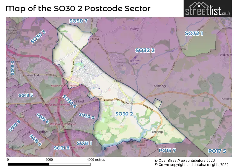
The SO30 2 Postcode shares a border with SO30 0 (Hedge End), SO30 3 (West End), SO30 4 (Hedge End), PO15 7 (Whiteley), SO31 1 (Park Gate, Bursledon, Burridge), SO32 2 (Botley, Swanmore, Waltham Chase) and SO50 7 (Fair Oak, Horton Heath, Fishers Pond).
The sector is within the post town of SOUTHAMPTON.
SO30 2 is a postcode sector within the SO30 postcode district which is within the SO Southampton postcode area.
The Royal Mail delivery office for the SO30 2 postal sector is the Hedge End Delivery Office.
The area of the SO30 2 postcode sector is 5.51 square miles which is 14.28 square kilometres or 3,528.44 square acres.
The SO30 2 postcode sector is crossed by the M27 motorway.
Waterways within the SO30 2 postcode sector include the River Hamble, Hamble.

Map of the SO30 2 Postcode Sector
Explore the SO30 2 postcode sector by using our free interactive map.
| S | O | 3 | 0 | - | 2 | X | X |
| S | O | 3 | 0 | Space | 2 | Letter | Letter |
Official List of Streets
Botley (58 Streets)
Hedge End (90 Streets)
Curbridge (22 Streets)
West End (7 Streets)
Curdridge (3 Streets)
Unofficial Streets or Alternative Spellings
Whiteley
WHITELEY WAYBotley
WINCHESTER ROADHedge End
CHARLES WATTS WAY DUKE ROAD FERNDALE KINGS COPSE AVENUE LOWER NORTHAM ROAD SHAMBLEHURST LANE NORTH WESTWARD ROADFair Oak
BOTLEY ROADHorton Heath
BURNETTS LANEBurridge
BOTLEY ROADWeather Forecast for SO30 2
Press Button to Show Forecast for Botley
| Time Period | Icon | Description | Temperature | Rain Probability | Wind |
|---|---|---|---|---|---|
| 00:00 to 03:00 | Clear night | 7.0°C (feels like 5.0°C) | 0.00% | NNE 7 mph | |
| 03:00 to 06:00 | Clear night | 4.0°C (feels like 2.0°C) | 1.00% | N 4 mph | |
| 06:00 to 09:00 | Sunny day | 4.0°C (feels like 2.0°C) | 0.00% | N 4 mph | |
| 09:00 to 12:00 | Cloudy | 9.0°C (feels like 6.0°C) | 3.00% | N 9 mph | |
| 12:00 to 15:00 | Cloudy | 11.0°C (feels like 9.0°C) | 4.00% | N 11 mph | |
| 15:00 to 18:00 | Cloudy | 12.0°C (feels like 10.0°C) | 4.00% | N 11 mph | |
| 18:00 to 21:00 | Cloudy | 11.0°C (feels like 10.0°C) | 4.00% | N 7 mph | |
| 21:00 to 00:00 | Cloudy | 8.0°C (feels like 7.0°C) | 4.00% | NNE 4 mph |
Press Button to Show Forecast for Botley
| Time Period | Icon | Description | Temperature | Rain Probability | Wind |
|---|---|---|---|---|---|
| 00:00 to 03:00 | Partly cloudy (night) | 7.0°C (feels like 6.0°C) | 1.00% | NNE 4 mph | |
| 03:00 to 06:00 | Partly cloudy (night) | 6.0°C (feels like 4.0°C) | 1.00% | N 4 mph | |
| 06:00 to 09:00 | Cloudy | 6.0°C (feels like 4.0°C) | 5.00% | N 7 mph | |
| 09:00 to 12:00 | Overcast | 8.0°C (feels like 6.0°C) | 8.00% | NNE 9 mph | |
| 12:00 to 15:00 | Overcast | 10.0°C (feels like 8.0°C) | 8.00% | NNE 11 mph | |
| 15:00 to 18:00 | Overcast | 11.0°C (feels like 9.0°C) | 8.00% | NNE 11 mph | |
| 18:00 to 21:00 | Cloudy | 11.0°C (feels like 9.0°C) | 5.00% | NNE 9 mph | |
| 21:00 to 00:00 | Partly cloudy (night) | 8.0°C (feels like 6.0°C) | 2.00% | NNE 9 mph |
Press Button to Show Forecast for Botley
| Time Period | Icon | Description | Temperature | Rain Probability | Wind |
|---|---|---|---|---|---|
| 00:00 to 03:00 | Clear night | 6.0°C (feels like 4.0°C) | 3.00% | NNE 7 mph | |
| 03:00 to 06:00 | Clear night | 5.0°C (feels like 2.0°C) | 3.00% | NNE 7 mph | |
| 06:00 to 09:00 | Partly cloudy (day) | 5.0°C (feels like 2.0°C) | 3.00% | NNE 7 mph | |
| 09:00 to 12:00 | Cloudy | 8.0°C (feels like 7.0°C) | 7.00% | NNE 7 mph | |
| 12:00 to 15:00 | Cloudy | 10.0°C (feels like 9.0°C) | 10.00% | N 7 mph | |
| 15:00 to 18:00 | Cloudy | 10.0°C (feels like 9.0°C) | 13.00% | NNW 7 mph | |
| 18:00 to 21:00 | Overcast | 9.0°C (feels like 7.0°C) | 19.00% | NW 7 mph | |
| 21:00 to 00:00 | Light rain | 8.0°C (feels like 6.0°C) | 46.00% | N 7 mph |
Press Button to Show Forecast for Botley
| Time Period | Icon | Description | Temperature | Rain Probability | Wind |
|---|---|---|---|---|---|
| 00:00 to 03:00 | Overcast | 7.0°C (feels like 5.0°C) | 14.00% | N 4 mph | |
| 03:00 to 06:00 | Cloudy | 7.0°C (feels like 5.0°C) | 8.00% | NNE 7 mph | |
| 06:00 to 09:00 | Cloudy | 7.0°C (feels like 5.0°C) | 7.00% | NNE 7 mph | |
| 09:00 to 12:00 | Cloudy | 9.0°C (feels like 7.0°C) | 7.00% | NNE 9 mph | |
| 12:00 to 15:00 | Cloudy | 11.0°C (feels like 10.0°C) | 10.00% | NNE 9 mph | |
| 15:00 to 18:00 | Cloudy | 12.0°C (feels like 10.0°C) | 10.00% | NNE 9 mph | |
| 18:00 to 21:00 | Cloudy | 12.0°C (feels like 10.0°C) | 7.00% | N 9 mph | |
| 21:00 to 00:00 | Partly cloudy (night) | 9.0°C (feels like 8.0°C) | 4.00% | N 7 mph |
Schools and Places of Education Within the SO30 2 Postcode Sector
Berrywood Primary School
Community school
Maunsell Way, Southampton, Hampshire, SO30 2TL
Head: Mr Chris Reilly
Ofsted Rating: Good
Inspection: 2021-05-06 (1080 days ago)
Website: Visit Berrywood Primary School Website
Phone: 01489780068
Number of Pupils: 632
Botley Church of England Controlled Primary School
Voluntary controlled school
52 High Street, Southampton, Hampshire, SO30 2EA
Head: Mr Joseph Cooil
Ofsted Rating: Good
Inspection: 2023-10-11 (192 days ago)
Website: Visit Botley Church of England Controlled Primary School Website
Phone: 01489782308
Number of Pupils: 386
Deer Park School
Free schools
Sika Avenue, Southampton, Hampshire, SO30 2HT
Head: Mr Matthew Jones
Ofsted Rating: Good
Inspection: 2023-11-30 (142 days ago)
Website: Visit Deer Park School Website
Phone: 01489351100
Number of Pupils: 278
Wellstead Primary School
Community school
Wellstead Way, Southampton, Hampshire, SO30 2LE
Head: Mrs Amanda Greenwood
Ofsted Rating: Good
Inspection: 2020-01-16 (1556 days ago)
Website: Visit Wellstead Primary School Website
Phone: 01489799351
Number of Pupils: 413
House Prices in the SO30 2 Postcode Sector
| Type of Property | 2018 Average | 2018 Sales | 2017 Average | 2017 Sales | 2016 Average | 2016 Sales | 2015 Average | 2015 Sales |
|---|---|---|---|---|---|---|---|---|
| Detached | £466,142 | 84 | £444,861 | 58 | £394,408 | 85 | £393,338 | 82 |
| Semi-Detached | £323,310 | 45 | £305,510 | 45 | £271,998 | 47 | £259,249 | 42 |
| Terraced | £250,968 | 78 | £258,986 | 89 | £240,598 | 76 | £221,162 | 112 |
| Flats | £177,388 | 49 | £151,483 | 26 | £166,852 | 47 | £154,833 | 72 |
Important Postcodes SO30 2 in the Postcode Sector
SO30 2DF is the postcode for Milbrook House, Grange Drive
SO30 2DY is the postcode for Driver and Vehicle Standards Agency, Bottings Industrial Estate, Curdridge, Driver and Vehicle Standards Agency, Bottings Industrial Estate, and Vehicle & Operator Service Agency, Bottings Industrial Estate, Hillsons Road
SO30 2EA is the postcode for Botley C of E Primary School, High Street, Botley, and Botley C of E Primary School, High Street
SO30 2ER is the postcode for FARMHOUSE, Manor Farm Country Park, Brook Lane, and ACTIVITY CENTRE, Manor Farm Country Park, Brook Lane
SO30 2ES is the postcode for The Botley Centre, High Street
SO30 2EZ is the postcode for Main Building, Deer Park School, Woodhouse Lane, and Sports Hall, Deer Park School, Woodhouse Lane
SO30 2HT is the postcode for Main Building, Deer Park School, Woodhouse Lane, and Sports Hall, Deer Park School, Woodhouse Lane
SO30 2JH is the postcode for Royal Mail, Hedge End Delivery Office Unit, 2 Nelson Industrial Park, Herald Road
SO30 2LE is the postcode for Wellstead School, Wellstead Way
SO30 2RA is the postcode for Eastleigh Borough Council, Council Depot, Botley Road
SO30 2TL is the postcode for Berrywood Primary School, Maunsel Way
SO30 2UN is the postcode for N H S Direct Hampshire & Isle of Wight, Strawberry Fields, Tollbar Way, Berrywood Business Village
SO30 2US is the postcode for St. Lukes Surgery, St. Lukes Close
| The SO30 2 Sector is within these Local Authorities |
|
|---|---|
| The SO30 2 Sector is within these Counties |
|
| The SO30 2 Sector is within these Water Company Areas |
|