The SO19 9 postcode sector is within the county of Hampshire.
Did you know? According to the 2021 Census, the SO19 9 postcode sector is home to a bustling 17,143 residents!
Given that each sector allows for 400 unique postcode combinations. Letters C, I, K, M, O and V are not allowed in the last two letters of a postcode. With 298 postcodes already in use, this leaves 102 units available.
The SO19 9 postal code covers the settlement of SOUTHAMPTON.
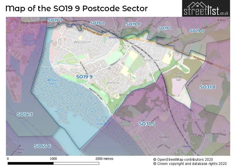
The SO19 9 Postcode shares a border with SO19 0 (SOUTHAMPTON), SO19 1 (SOUTHAMPTON), SO19 2 (SOUTHAMPTON), SO19 8 (SOUTHAMPTON), SO31 5 (Netley Abbey), SO19 7 (SOUTHAMPTON) and SO31 8 (Bursledon).
The sector is within the post town of SOUTHAMPTON.
SO19 9 is a postcode sector within the SO31 postcode district which is within the SO Southampton postcode area.
The Royal Mail delivery office for the SO19 9 postal sector is the Sarisbury Green Delivery Office.
The area of the SO19 9 postcode sector is 1.52 square miles which is 3.93 square kilometres or 971.34 square acres.

Map of the SO19 9 Postcode Sector
Explore the SO19 9 postcode sector by using our free interactive map.
| S | O | 1 | 9 | - | 9 | X | X |
| S | O | 1 | 9 | Space | 9 | Letter | Letter |
Official List of Streets
SOUTHAMPTON (133 Streets)
Unofficial Streets or Alternative Spellings
SOUTHAMPTON
ADEY CLOSE BOTANY BAY ROAD BOTLEY ROAD BRIDGE ROAD FORT ROAD HAZEL ROAD HEPWORTH CLOSE PORCHESTER ROAD SPRING ROAD STATION ROAD BUTTS ROAD CANBERRA TOWERS CANDOVER COURT CHURCH VIEW GARRETT CLOSE GORDON TERRACE HOLT COURT HURSTBOURNE PLACE INGLESIDE ITCHEN BRIDGE JOHN THORNEYCROFT ROAD KEEPERS CROSSINGS KIMBERLEY COURT KIPLING COURT SEAWEED CLOSE SHOREBURS GREENWAY THE CRESCENT WESTON LANE ROUNDABOUT WESTON PARADE WITTSENDNetley Abbey
GRANGE ROAD STENBURY WAY WOOLSTON ROADBursledon
PORTSMOUTH ROADWeather Forecast for SO19 9
Press Button to Show Forecast for Woolston
| Time Period | Icon | Description | Temperature | Rain Probability | Wind |
|---|---|---|---|---|---|
| 12:00 to 15:00 | Cloudy | 11.0°C (feels like 9.0°C) | 49.00% | WSW 11 mph | |
| 15:00 to 18:00 | Cloudy | 10.0°C (feels like 8.0°C) | 50.00% | WSW 11 mph | |
| 18:00 to 21:00 | Cloudy | 10.0°C (feels like 8.0°C) | 12.00% | WNW 9 mph | |
| 21:00 to 00:00 | Cloudy | 9.0°C (feels like 7.0°C) | 9.00% | NNW 7 mph |
Press Button to Show Forecast for Woolston
| Time Period | Icon | Description | Temperature | Rain Probability | Wind |
|---|---|---|---|---|---|
| 00:00 to 03:00 | Cloudy | 7.0°C (feels like 5.0°C) | 5.00% | NE 7 mph | |
| 03:00 to 06:00 | Cloudy | 7.0°C (feels like 4.0°C) | 6.00% | NE 7 mph | |
| 06:00 to 09:00 | Cloudy | 7.0°C (feels like 4.0°C) | 8.00% | ENE 9 mph | |
| 09:00 to 12:00 | Cloudy | 8.0°C (feels like 5.0°C) | 9.00% | ENE 9 mph | |
| 12:00 to 15:00 | Overcast | 10.0°C (feels like 8.0°C) | 18.00% | E 9 mph | |
| 15:00 to 18:00 | Overcast | 10.0°C (feels like 9.0°C) | 17.00% | ESE 7 mph | |
| 18:00 to 21:00 | Cloudy | 10.0°C (feels like 9.0°C) | 11.00% | ESE 7 mph | |
| 21:00 to 00:00 | Cloudy | 8.0°C (feels like 6.0°C) | 12.00% | ESE 7 mph |
Press Button to Show Forecast for Woolston
| Time Period | Icon | Description | Temperature | Rain Probability | Wind |
|---|---|---|---|---|---|
| 00:00 to 03:00 | Overcast | 8.0°C (feels like 6.0°C) | 18.00% | ENE 7 mph | |
| 03:00 to 06:00 | Light rain | 7.0°C (feels like 4.0°C) | 51.00% | ENE 9 mph | |
| 06:00 to 09:00 | Cloudy | 7.0°C (feels like 4.0°C) | 18.00% | ENE 11 mph | |
| 09:00 to 12:00 | Cloudy | 9.0°C (feels like 7.0°C) | 15.00% | ENE 11 mph | |
| 12:00 to 15:00 | Cloudy | 12.0°C (feels like 9.0°C) | 20.00% | E 13 mph | |
| 15:00 to 18:00 | Light rain | 12.0°C (feels like 9.0°C) | 52.00% | E 11 mph | |
| 18:00 to 21:00 | Heavy rain | 11.0°C (feels like 8.0°C) | 75.00% | ENE 13 mph | |
| 21:00 to 00:00 | Light rain | 10.0°C (feels like 7.0°C) | 54.00% | ENE 13 mph |
Press Button to Show Forecast for Woolston
| Time Period | Icon | Description | Temperature | Rain Probability | Wind |
|---|---|---|---|---|---|
| 00:00 to 03:00 | Light rain | 9.0°C (feels like 7.0°C) | 56.00% | ENE 13 mph | |
| 03:00 to 06:00 | Heavy rain shower (night) | 9.0°C (feels like 6.0°C) | 61.00% | ENE 11 mph | |
| 06:00 to 09:00 | Light rain | 10.0°C (feels like 8.0°C) | 48.00% | ESE 9 mph | |
| 09:00 to 12:00 | Light rain shower (day) | 11.0°C (feels like 8.0°C) | 42.00% | SSE 11 mph | |
| 12:00 to 15:00 | Light rain shower (day) | 12.0°C (feels like 9.0°C) | 40.00% | SW 13 mph | |
| 15:00 to 18:00 | Light rain shower (day) | 12.0°C (feels like 9.0°C) | 36.00% | WSW 13 mph | |
| 18:00 to 21:00 | Light rain shower (day) | 11.0°C (feels like 9.0°C) | 35.00% | WSW 13 mph | |
| 21:00 to 00:00 | Clear night | 10.0°C (feels like 8.0°C) | 6.00% | WSW 9 mph |
Schools and Places of Education Within the SO19 9 Postcode Sector
Oasis Academy Mayfield
Academy sponsor led
Ashley Crescent, Southampton, Hampshire, SO19 9NA
Head: Ms Claire Taylor
Ofsted Rating: Requires improvement
Inspection: 2020-03-04 (1513 days ago)
Website: Visit Oasis Academy Mayfield Website
Phone: 02380328128
Number of Pupils: 887
Weston Park Primary School
Academy sponsor led
Newtown Road, Southampton, Hampshire, SO19 9HX
Head: Mr James Wiltshire
Ofsted Rating: Good
Inspection: 2021-12-01 (876 days ago)
Website: Visit Weston Park Primary School Website
Phone: 02380448962
Number of Pupils: 491
Weston Shore Infant School
Academy sponsor led
Foxcott Close, Southampton, , SO19 9JQ
Head: Mr James Wiltshire
Ofsted Rating: Good
Inspection: 2023-10-04 (204 days ago)
Website: Visit Weston Shore Infant School Website
Phone: 02380390399
Number of Pupils: 75
House Prices in the SO19 9 Postcode Sector
| Type of Property | 2018 Average | 2018 Sales | 2017 Average | 2017 Sales | 2016 Average | 2016 Sales | 2015 Average | 2015 Sales |
|---|---|---|---|---|---|---|---|---|
| Detached | £296,605 | 33 | £284,617 | 35 | £278,027 | 35 | £280,776 | 27 |
| Semi-Detached | £237,035 | 83 | £238,831 | 88 | £225,597 | 87 | £204,612 | 86 |
| Terraced | £210,292 | 77 | £194,603 | 81 | £192,450 | 115 | £171,924 | 73 |
| Flats | £180,090 | 192 | £188,528 | 150 | £168,912 | 165 | £158,950 | 132 |
Important Postcodes SO19 9 in the Postcode Sector
SO19 9AL is the postcode for The Woolston Lodge Surgery, 66 Portsmouth Road
SO19 9AN is the postcode for 68a Portsmouth Road
SO19 9DB is the postcode for Woolston Infant School, Florence Road, and WOOLSTON INFANT SCHOOL, FLORENCE ROAD, SOUTHAMPTON
SO19 9DW is the postcode for Woolston Health Clinic, Woodley Road
SO19 9GH is the postcode for Weston Lane Centre for Healthy Living, Weston Lane
SO19 9HL is the postcode for Weston Park Junior School, Weston Lane
SO19 9HX is the postcode for REEMA BUILDING, Weston Park Primary School, Newtown Road, MAIN BUILDING, Weston Park Primary School, Newtown Road, Weston Park Primary School, Newtown Road, and Weston Park Infant School, Newtown Road
SO19 9JF is the postcode for Chamberlayne Park School, Winchfield Close
SO19 9JQ is the postcode for Weston Shore Infant School, Foxcott Close
SO19 9LX is the postcode for OASIS ACADEMY, Oasis Academy Mayfield, The Grove
SO19 9NA is the postcode for Oasis Academy Mayfield, Ashley Crescent
SO19 9QP is the postcode for Patrick Moore Building, Chamberlayne College of Arts, Tickleford Drive, Main Building, Chamberlayne College of Arts, Tickleford Drive, Darcey Russell Building, Chamberlayne College of Arts, Tickleford Drive, Technology Building, Chamberlayne College of Arts, Tickleford Drive, Emma Richards Building, Chamberlayne College of Arts, Tickleford Drive, and Chamberlayne College For The Arts, Tickleford Drive
SO19 9SJ is the postcode for Chamberlayne Leisure Centre, 150 Weston Lane, and Active Nation, Chamberlayne Leisure Centre, 150 Weston Lane
| The SO19 9 Sector is within these Local Authorities |
|
|---|---|
| The SO19 9 Sector is within these Counties |
|
| The SO19 9 Sector is within these Water Company Areas |
|