The SR4 0 postcode sector is within the county of Tyne & Wear.
Did you know? According to the 2021 Census, the SR4 0 postcode sector is home to a bustling 8,501 residents!
Given that each sector allows for 400 unique postcode combinations. Letters C, I, K, M, O and V are not allowed in the last two letters of a postcode. With 182 postcodes already in use, this leaves 218 units available.
The largest settlements in the SR4 0 postal code are SUNDERLAND and South Hylton.
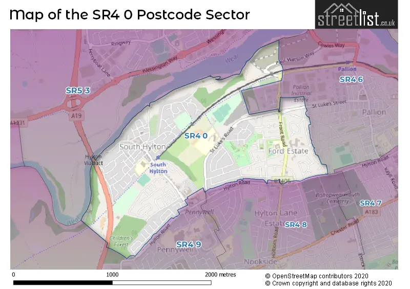
The SR4 0 Postcode shares a border with SR4 6 (SUNDERLAND), SR4 8 (SUNDERLAND), SR4 9 (SUNDERLAND) and SR5 3 (SUNDERLAND, Castletown, Sunderland Enterprise Park).
The sector is within the post town of SUNDERLAND.
SR4 0 is a postcode sector within the SR4 postcode district which is within the SR Sunderland postcode area.
The Royal Mail delivery office for the SR4 0 postal sector is the Sunderland Delivery Office.
The area of the SR4 0 postcode sector is 0.97 square miles which is 2.50 square kilometres or 617.71 square acres.
The SR4 0 postcode sector is crossed by the A19 Major A road.

Map of the SR4 0 Postcode Sector
Explore the SR4 0 postcode sector by using our free interactive map.
| S | R | 4 | - | 0 | X | X |
| S | R | 4 | Space | 0 | Letter | Letter |
Official List of Streets
SUNDERLAND (103 Streets)
South Hylton (19 Streets)
Unofficial Streets or Alternative Spellings
Weather Forecast for SR4 0
Press Button to Show Forecast for South Hylton
| Time Period | Icon | Description | Temperature | Rain Probability | Wind |
|---|---|---|---|---|---|
| 09:00 to 12:00 | Cloudy | 5.0°C (feels like 2.0°C) | 30.00% | N 11 mph | |
| 12:00 to 15:00 | Cloudy | 6.0°C (feels like 3.0°C) | 6.00% | N 11 mph | |
| 15:00 to 18:00 | Partly cloudy (day) | 7.0°C (feels like 3.0°C) | 4.00% | NNE 13 mph | |
| 18:00 to 21:00 | Partly cloudy (day) | 6.0°C (feels like 3.0°C) | 1.00% | NNE 11 mph | |
| 21:00 to 00:00 | Cloudy | 5.0°C (feels like 2.0°C) | 4.00% | NNE 7 mph |
Press Button to Show Forecast for South Hylton
| Time Period | Icon | Description | Temperature | Rain Probability | Wind |
|---|---|---|---|---|---|
| 00:00 to 03:00 | Cloudy | 4.0°C (feels like 2.0°C) | 31.00% | NNW 4 mph | |
| 03:00 to 06:00 | Cloudy | 3.0°C (feels like 1.0°C) | 32.00% | WNW 4 mph | |
| 06:00 to 09:00 | Cloudy | 3.0°C (feels like 1.0°C) | 5.00% | NW 4 mph | |
| 09:00 to 12:00 | Cloudy | 6.0°C (feels like 4.0°C) | 7.00% | NE 7 mph | |
| 12:00 to 15:00 | Cloudy | 7.0°C (feels like 5.0°C) | 26.00% | ENE 7 mph | |
| 15:00 to 18:00 | Cloudy | 8.0°C (feels like 6.0°C) | 9.00% | E 7 mph | |
| 18:00 to 21:00 | Partly cloudy (day) | 7.0°C (feels like 5.0°C) | 5.00% | E 7 mph | |
| 21:00 to 00:00 | Clear night | 4.0°C (feels like 2.0°C) | 2.00% | SE 4 mph |
Press Button to Show Forecast for South Hylton
| Time Period | Icon | Description | Temperature | Rain Probability | Wind |
|---|---|---|---|---|---|
| 00:00 to 03:00 | Partly cloudy (night) | 2.0°C (feels like 1.0°C) | 2.00% | S 4 mph | |
| 03:00 to 06:00 | Partly cloudy (night) | 1.0°C (feels like 0.0°C) | 4.00% | SSW 4 mph | |
| 06:00 to 09:00 | Partly cloudy (day) | 3.0°C (feels like 1.0°C) | 6.00% | SSE 4 mph | |
| 09:00 to 12:00 | Cloudy | 7.0°C (feels like 5.0°C) | 11.00% | ESE 7 mph | |
| 12:00 to 15:00 | Cloudy | 9.0°C (feels like 6.0°C) | 10.00% | ESE 9 mph | |
| 15:00 to 18:00 | Partly cloudy (day) | 9.0°C (feels like 6.0°C) | 8.00% | E 11 mph | |
| 18:00 to 21:00 | Partly cloudy (day) | 8.0°C (feels like 5.0°C) | 9.00% | E 9 mph | |
| 21:00 to 00:00 | Cloudy | 6.0°C (feels like 3.0°C) | 13.00% | E 7 mph |
Press Button to Show Forecast for South Hylton
| Time Period | Icon | Description | Temperature | Rain Probability | Wind |
|---|---|---|---|---|---|
| 00:00 to 03:00 | Cloudy | 5.0°C (feels like 3.0°C) | 14.00% | ENE 7 mph | |
| 03:00 to 06:00 | Cloudy | 5.0°C (feels like 3.0°C) | 16.00% | NE 9 mph | |
| 06:00 to 09:00 | Overcast | 7.0°C (feels like 3.0°C) | 22.00% | NE 11 mph | |
| 09:00 to 12:00 | Light rain | 7.0°C (feels like 4.0°C) | 53.00% | NE 13 mph | |
| 12:00 to 15:00 | Light rain | 8.0°C (feels like 5.0°C) | 57.00% | NNE 13 mph | |
| 15:00 to 18:00 | Light rain | 8.0°C (feels like 5.0°C) | 57.00% | NNE 11 mph | |
| 18:00 to 21:00 | Light rain | 9.0°C (feels like 7.0°C) | 49.00% | N 7 mph | |
| 21:00 to 00:00 | Clear night | 6.0°C (feels like 4.0°C) | 10.00% | ESE 7 mph |
Schools and Places of Education Within the SR4 0 Postcode Sector
Highfield Academy
Academy converter
Fordfield Road, Sunderland, Tyne and Wear, SR4 0DA
Head: Mrs Melanie Davies
Ofsted Rating: Good
Inspection: 2022-10-12 (561 days ago)
Website: Visit Highfield Academy Website
Phone: 01915537655
Number of Pupils: 422
North View Academy
Academy special converter
St. Lukes Road, Sunderland, Tyne and Wear, SR4 0HB
Head: Mr Gary Mellefont
Ofsted Rating: Good
Inspection: 2023-11-29 (148 days ago)
Website: Visit North View Academy Website
Phone: 01917070122
Number of Pupils: 85
South Hylton Primary Academy
Academy converter
Union Street, Sunderland, Tyne and Wear, SR4 0LS
Head: Mr Christopher Mitchinson
Ofsted Rating: Good
Inspection: 2021-09-15 (953 days ago)
Website: Visit South Hylton Primary Academy Website
Phone: 01915634180
Number of Pupils: 277
House Prices in the SR4 0 Postcode Sector
| Type of Property | 2018 Average | 2018 Sales | 2017 Average | 2017 Sales | 2016 Average | 2016 Sales | 2015 Average | 2015 Sales |
|---|---|---|---|---|---|---|---|---|
| Detached | £162,428 | 28 | £157,239 | 21 | £155,834 | 20 | £147,223 | 15 |
| Semi-Detached | £108,512 | 50 | £102,580 | 43 | £102,329 | 64 | £104,345 | 36 |
| Terraced | £87,367 | 23 | £83,646 | 13 | £76,300 | 10 | £80,430 | 15 |
| Flats | £62,800 | 5 | £67,607 | 7 | £52,795 | 5 | £0 | 0 |
Important Postcodes SR4 0 in the Postcode Sector
SR4 0DA is the postcode for Highfield Community Primary School, Fordfield Road, Highfield Academy, Fordfield Road, and HIGHFIELD COMMUNITY PRIMARY SCHOOL, FORDFIELD ROAD, SUNDERLAND
SR4 0HB is the postcode for NORTH VIEW ACADEMY, SAINT LUKES ROAD, and North View Academy, St. Luke's Road
SR4 0JL is the postcode for MAIN OFFICE BLOCK, City of Sunderland, South Hylton Depot, Hylton Bank, and City of Sunderland, South Hylton Depot, Hylton Bank
SR4 0LL is the postcode for 28, Hylton Bank
SR4 0LS is the postcode for South Hylton Primary Academy, Union Street, South Hylton Primary School, Union Street, South Hylton, and South Hylton Primary Academy, Union Street, South Hylton
| The SR4 0 Sector is within these Local Authorities |
|
|---|---|
| The SR4 0 Sector is within these Counties |
|
| The SR4 0 Sector is within these Water Company Areas |
|