The SR5 3 postcode sector is within the county of Tyne & Wear.
Did you know? According to the 2021 Census, the SR5 3 postcode sector is home to a bustling 8,478 residents!
Given that each sector allows for 400 unique postcode combinations. Letters C, I, K, M, O and V are not allowed in the last two letters of a postcode. With 220 postcodes already in use, this leaves 180 units available.
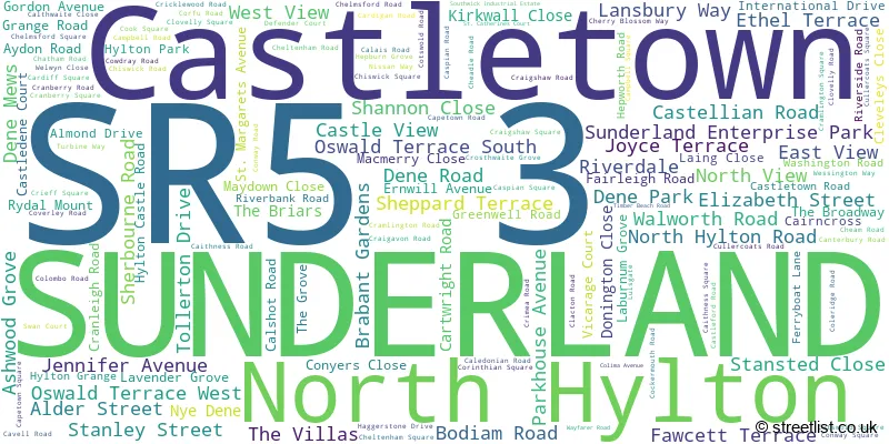
The largest settlement in the SR5 3 postal code is SUNDERLAND followed by Castletown, and Sunderland Enterprise Park.
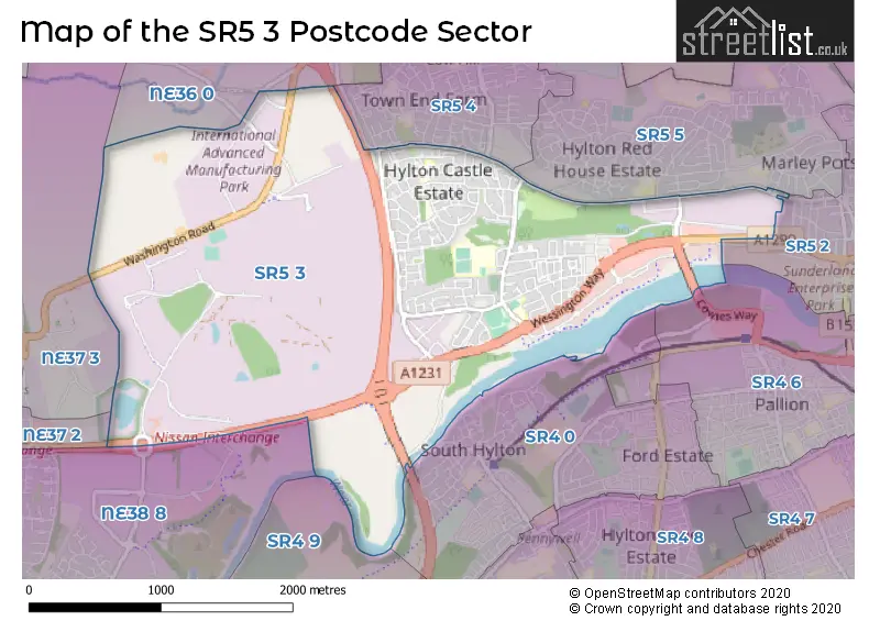
The SR5 3 Postcode shares a border with NE37 3 (WASHINGTON), SR5 4 (SUNDERLAND), SR5 5 (SUNDERLAND), NE36 0 (EAST BOLDON, West Boldon), NE37 2 (WASHINGTON, Hertburn), NE38 8 (WASHINGTON, Pattinson Industrial Estate), SR4 0 (SUNDERLAND, South Hylton), SR4 6 (SUNDERLAND), SR4 9 (SUNDERLAND) and SR5 2 (SUNDERLAND, Southwick, Sunderland Enterprise Park).
The sector is within the post town of SUNDERLAND.
SR5 3 is a postcode sector within the SR5 postcode district which is within the SR Sunderland postcode area.
The Royal Mail delivery office for the SR5 3 postal sector is the Sunderland Delivery Office.
The area of the SR5 3 postcode sector is 3.60 square miles which is 9.33 square kilometres or 2,304.62 square acres.
The SR5 3 postcode sector is crossed by the A19 Major A road.

Map of the SR5 3 Postcode Sector
Explore the SR5 3 postcode sector by using our free interactive map.
| S | R | 5 | - | 3 | X | X |
| S | R | 5 | Space | 3 | Letter | Letter |
Official List of Streets
SUNDERLAND (118 Streets)
Castletown (13 Streets)
Sunderland Enterprise Park (4 Streets)
North Hylton (1 Streets)
Unofficial Streets or Alternative Spellings
SUNDERLAND
BLACKWOOD ROAD HOLLYWOOD AVENUE RADLETT ROAD ROTHERFIELD ROAD YEWTREE AVENUE BARONS QUAY ROAD CASTLETOWN WAY COWIES WAY DONNINGTON CLOSE HYLTON GRANGE INTERCHANGE HYLTON PARK ROAD HYLTON VIADUCT LILLEY GROVE LINNET GROVE NISSAN INTERCHANGE NORTHERN SPIRE OSWALD TERRACE RINGWAY SUNDERLAND HIGHWAY SUNRISE ENTERPRISE PARK THOMPSON CRESCENTWest Boldon
HYLTON LANEWASHINGTON
BARMSTON LANE INFINITI DRIVESUNDERLAND,
WASHINGTON ROADWeather Forecast for SR5 3
Press Button to Show Forecast for Castletown (Tyne & Wear)
| Time Period | Icon | Description | Temperature | Rain Probability | Wind |
|---|---|---|---|---|---|
| 12:00 to 15:00 | Cloudy | 7.0°C (feels like 4.0°C) | 6.00% | NNE 11 mph | |
| 15:00 to 18:00 | Partly cloudy (day) | 7.0°C (feels like 4.0°C) | 4.00% | NNE 13 mph | |
| 18:00 to 21:00 | Partly cloudy (day) | 6.0°C (feels like 3.0°C) | 1.00% | NNE 9 mph | |
| 21:00 to 00:00 | Cloudy | 5.0°C (feels like 3.0°C) | 5.00% | NNE 4 mph |
Press Button to Show Forecast for Castletown (Tyne & Wear)
| Time Period | Icon | Description | Temperature | Rain Probability | Wind |
|---|---|---|---|---|---|
| 00:00 to 03:00 | Cloudy | 4.0°C (feels like 2.0°C) | 7.00% | NNW 4 mph | |
| 03:00 to 06:00 | Cloudy | 3.0°C (feels like 1.0°C) | 4.00% | NW 4 mph | |
| 06:00 to 09:00 | Cloudy | 4.0°C (feels like 1.0°C) | 5.00% | NW 4 mph | |
| 09:00 to 12:00 | Cloudy | 6.0°C (feels like 4.0°C) | 34.00% | NE 7 mph | |
| 12:00 to 15:00 | Cloudy | 8.0°C (feels like 6.0°C) | 26.00% | ENE 7 mph | |
| 15:00 to 18:00 | Cloudy | 8.0°C (feels like 6.0°C) | 9.00% | E 7 mph | |
| 18:00 to 21:00 | Partly cloudy (day) | 7.0°C (feels like 5.0°C) | 5.00% | E 7 mph | |
| 21:00 to 00:00 | Clear night | 4.0°C (feels like 2.0°C) | 2.00% | SE 4 mph |
Press Button to Show Forecast for Castletown (Tyne & Wear)
| Time Period | Icon | Description | Temperature | Rain Probability | Wind |
|---|---|---|---|---|---|
| 00:00 to 03:00 | Partly cloudy (night) | 3.0°C (feels like 1.0°C) | 2.00% | S 4 mph | |
| 03:00 to 06:00 | Partly cloudy (night) | 2.0°C (feels like 0.0°C) | 4.00% | SSW 4 mph | |
| 06:00 to 09:00 | Partly cloudy (day) | 3.0°C (feels like 1.0°C) | 5.00% | SSE 4 mph | |
| 09:00 to 12:00 | Cloudy | 8.0°C (feels like 6.0°C) | 11.00% | ESE 7 mph | |
| 12:00 to 15:00 | Cloudy | 9.0°C (feels like 7.0°C) | 10.00% | ESE 9 mph | |
| 15:00 to 18:00 | Partly cloudy (day) | 9.0°C (feels like 6.0°C) | 8.00% | E 11 mph | |
| 18:00 to 21:00 | Partly cloudy (day) | 8.0°C (feels like 5.0°C) | 9.00% | E 9 mph | |
| 21:00 to 00:00 | Cloudy | 6.0°C (feels like 4.0°C) | 13.00% | E 7 mph |
Press Button to Show Forecast for Castletown (Tyne & Wear)
| Time Period | Icon | Description | Temperature | Rain Probability | Wind |
|---|---|---|---|---|---|
| 00:00 to 03:00 | Cloudy | 5.0°C (feels like 3.0°C) | 14.00% | ENE 7 mph | |
| 03:00 to 06:00 | Cloudy | 6.0°C (feels like 3.0°C) | 16.00% | NE 9 mph | |
| 06:00 to 09:00 | Overcast | 7.0°C (feels like 4.0°C) | 22.00% | NE 11 mph | |
| 09:00 to 12:00 | Light rain | 8.0°C (feels like 4.0°C) | 51.00% | NE 13 mph | |
| 12:00 to 15:00 | Light rain | 8.0°C (feels like 5.0°C) | 57.00% | NNE 13 mph | |
| 15:00 to 18:00 | Light rain | 9.0°C (feels like 6.0°C) | 57.00% | NNE 11 mph | |
| 18:00 to 21:00 | Light rain shower (day) | 9.0°C (feels like 7.0°C) | 39.00% | N 7 mph | |
| 21:00 to 00:00 | Clear night | 6.0°C (feels like 4.0°C) | 10.00% | ESE 7 mph |
Schools and Places of Education Within the SR5 3 Postcode Sector
Castle View Enterprise Academy
Academy sponsor led
Cartwright Road, Sunderland, Tyne and Wear, SR5 3DX
Head: Mrs Joanne Owens
Ofsted Rating: Good
Inspection: 2023-06-28 (302 days ago)
Website: Visit Castle View Enterprise Academy Website
Phone: 01915946330
Number of Pupils: 1021
Castletown Primary School
Community school
Grange Road, Sunderland, Tyne and Wear, SR5 3EQ
Head: Mr Lee Duncan
Ofsted Rating: Good
Inspection: 2022-03-23 (764 days ago)
Website: Visit Castletown Primary School Website
Phone: 01915497777
Number of Pupils: 378
Education and Services for People with Autism
Special post 16 institution
Ferryboat Lane, Sunderland, , SR5 3RL
Head: Mr Patrick Cahill
Ofsted Rating: Good
Inspection: 2022-10-05 (568 days ago)
Website: Visit Education and Services for People with Autism Website
Phone: 01915165080
Number of Pupils: 0
Hylton Castle Primary School
Community school
Caithness Road, Sunderland, Tyne and Wear, SR5 3RE
Head: Mrs Lisa Wood
Ofsted Rating: Good
Inspection: 2022-07-06 (659 days ago)
Website: Visit Hylton Castle Primary School Website
Phone: 01915623299
Number of Pupils: 226
Trinity Academy New Bridge
Academy special sponsor led
Craigshaw Road, Sunderland, , SR5 3NF
Head: Mrs Sarah Armstrong
Ofsted Rating: Requires improvement
Inspection: 2023-04-26 (365 days ago)
Website: Visit Trinity Academy New Bridge Website
Phone: 01912986950
Number of Pupils: 131
House Prices in the SR5 3 Postcode Sector
| Type of Property | 2018 Average | 2018 Sales | 2017 Average | 2017 Sales | 2016 Average | 2016 Sales | 2015 Average | 2015 Sales |
|---|---|---|---|---|---|---|---|---|
| Detached | £197,921 | 7 | £181,611 | 9 | £195,614 | 7 | £191,200 | 5 |
| Semi-Detached | £93,758 | 56 | £90,146 | 58 | £95,030 | 46 | £87,895 | 40 |
| Terraced | £70,050 | 23 | £77,454 | 28 | £71,039 | 19 | £72,392 | 13 |
| Flats | £45,000 | 1 | £35,250 | 4 | £50,000 | 1 | £29,000 | 1 |
Important Postcodes SR5 3 in the Postcode Sector
SR5 3DX is the postcode for Castle View School, Cartwright Road, and Castle View Enterprise Academy, Cartwright Road
SR5 3EQ is the postcode for Castletown Primary School, Grange Road
SR5 3HE is the postcode for SKILLS ACADEMY FOR MANUFACTURING AND INNOVATION, Gateshead College, Washington Road
SR5 3JJ is the postcode for Driver and Vehicle Standards Agency, Riverbank Road
SR5 3NF is the postcode for THE NEW BRIDGE ACADEMY, CRAIGSHAW ROAD, SUNDERLAND, The New Bridge Academy (Upper), Craigshaw Road, and The New Bridge Academy, Craigshaw Road
SR5 3NN is the postcode for KS4 Cheadle Centre, Cheadle Road
SR5 3NY is the postcode for Future Technology Centre, Barmston Court, Nissan Way, FTC2, Future Technology Centre, Barmston Court, Nissan Way, and FTC1, Future Technology Centre, Barmston Court, Nissan Way
SR5 3NZ is the postcode for Washington Business Centre, 2 Turbine Way
SR5 3QL is the postcode for Hylton Castle Primary School, Cramlington Road, (To Be Demolished), Hylton Castle Primary School, and Hylton Castle Primary School, Cramlington Road, Hylton Castle
SR5 3QY is the postcode for BATC, Tyne & Wear Fire & Rescue Service, Headquarters, Nissan Way, USAR & APPLIANCE AREA, Tyne & Wear Fire & Rescue Service, Headquarters, Nissan Way, and Tyne & Wear Fire & Rescue Service, Headquarters, Nissan Way
SR5 3RE is the postcode for Hylton Castle Primary School, Caithness Road, and Hylton Castle Primary School, Cramlington Road, Hylton Castle
SR5 3SD is the postcode for 7 Colombo Road
SR5 3TX is the postcode for Unit 6a, Southwick Industrial Estate
SR5 3XB is the postcode for Sunderland Teaching Primary Care Trust, Pemberton House, Colima Avenue, University of Sunderland, The Industry Centre, 1 Colima Avenue, Sunderland Teaching Primary Care Trust, Pemberton House, Colima Avenue, Sunderland Enterprise Park, Loftus House, Colima Avenue, and Unit E, Colima Avenue
| The SR5 3 Sector is within these Local Authorities |
|
|---|---|
| The SR5 3 Sector is within these Counties |
|
| The SR5 3 Sector is within these Water Company Areas |
|