The SS12 9 postcode sector is within the county of Essex.
Did you know? According to the 2021 Census, the SS12 9 postcode sector is home to a bustling 11,441 residents!
Given that each sector allows for 400 unique postcode combinations. Letters C, I, K, M, O and V are not allowed in the last two letters of a postcode. With 231 postcodes already in use, this leaves 169 units available.
The largest settlements in the SS12 9 postal code are WICKFORD and North Benfleet.
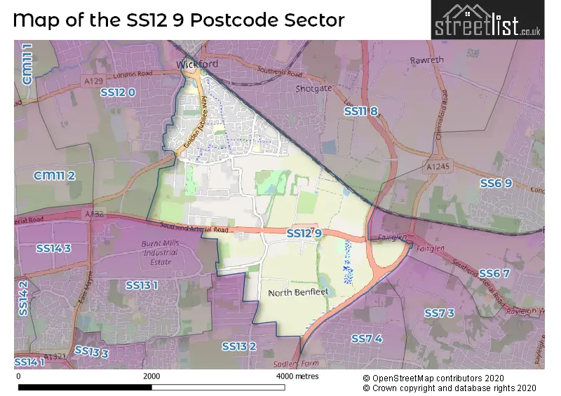
The SS12 9 Postcode shares a border with SS6 9 (RAYLEIGH), SS7 3 (BENFLEET), SS13 2 (BASILDON, Pitsea, Bowers Gifford), SS6 7 (RAYLEIGH, Brook Road Industrial Estate), SS7 4 (BENFLEET), SS11 7 (WICKFORD, Runwell, Battlesbridge), SS11 8 (WICKFORD, Rawreth), SS12 0 (WICKFORD) and SS13 1 (BASILDON, Pitsea, Burnt Mills Industrial Estate).
The sector is within the post town of WICKFORD.
SS12 9 is a postcode sector within the SS12 postcode district which is within the SS Southend-on-Sea postcode area.
The Royal Mail delivery office for the SS12 9 postal sector is the Wickford Delivery Office.
The area of the SS12 9 postcode sector is 3.10 square miles which is 8.02 square kilometres or 1,981.22 square acres.
Waterways within the SS12 9 postcode sector include the River Crouch.

Map of the SS12 9 Postcode Sector
Explore the SS12 9 postcode sector by using our free interactive map.
| S | S | 1 | 2 | - | 9 | X | X |
| S | S | 1 | 2 | Space | 9 | Letter | Letter |
Official List of Streets
WICKFORD (180 Streets)
Unofficial Streets or Alternative Spellings
WICKFORD
KERSHAWS CLOSE MARKET ROADBASILDON
BURNT MILLS ROAD LAWRENCE ROAD WINDSOR ROADBASILDON,
HOVEFIELDS AVENUECrays Hill
LONDON ROADBowers Gifford
POUND LANEPitsea
OSBORNE ROADBENFLEET
RUSHBOTTOM LANEGidea Park
SOUTHEND ARTERIAL ROADWeather Forecast for SS12 9
Press Button to Show Forecast for Wickford
| Time Period | Icon | Description | Temperature | Rain Probability | Wind |
|---|---|---|---|---|---|
| 00:00 to 03:00 | Partly cloudy (night) | 5.0°C (feels like 2.0°C) | 1.00% | NW 9 mph | |
| 03:00 to 06:00 | Cloudy | 4.0°C (feels like 1.0°C) | 3.00% | NW 9 mph | |
| 06:00 to 09:00 | Partly cloudy (day) | 4.0°C (feels like 1.0°C) | 1.00% | NNW 11 mph | |
| 09:00 to 12:00 | Cloudy | 8.0°C (feels like 5.0°C) | 4.00% | NNW 13 mph | |
| 12:00 to 15:00 | Cloudy | 10.0°C (feels like 6.0°C) | 4.00% | NNW 16 mph | |
| 15:00 to 18:00 | Cloudy | 10.0°C (feels like 7.0°C) | 5.00% | NNW 13 mph | |
| 18:00 to 21:00 | Partly cloudy (day) | 9.0°C (feels like 7.0°C) | 1.00% | N 9 mph | |
| 21:00 to 00:00 | Partly cloudy (night) | 5.0°C (feels like 4.0°C) | 1.00% | NNE 4 mph |
Press Button to Show Forecast for Wickford
| Time Period | Icon | Description | Temperature | Rain Probability | Wind |
|---|---|---|---|---|---|
| 00:00 to 03:00 | Partly cloudy (night) | 4.0°C (feels like 3.0°C) | 1.00% | WSW 4 mph | |
| 03:00 to 06:00 | Cloudy | 4.0°C (feels like 2.0°C) | 4.00% | WSW 7 mph | |
| 06:00 to 09:00 | Partly cloudy (day) | 6.0°C (feels like 3.0°C) | 2.00% | WSW 7 mph | |
| 09:00 to 12:00 | Cloudy | 9.0°C (feels like 6.0°C) | 7.00% | W 9 mph | |
| 12:00 to 15:00 | Overcast | 11.0°C (feels like 9.0°C) | 12.00% | WNW 11 mph | |
| 15:00 to 18:00 | Overcast | 12.0°C (feels like 9.0°C) | 15.00% | WNW 9 mph | |
| 18:00 to 21:00 | Cloudy | 10.0°C (feels like 8.0°C) | 13.00% | NNW 7 mph | |
| 21:00 to 00:00 | Cloudy | 7.0°C (feels like 6.0°C) | 6.00% | N 4 mph |
Press Button to Show Forecast for Wickford
| Time Period | Icon | Description | Temperature | Rain Probability | Wind |
|---|---|---|---|---|---|
| 00:00 to 03:00 | Partly cloudy (night) | 6.0°C (feels like 4.0°C) | 4.00% | NE 4 mph | |
| 03:00 to 06:00 | Cloudy | 5.0°C (feels like 3.0°C) | 5.00% | NNE 4 mph | |
| 06:00 to 09:00 | Cloudy | 5.0°C (feels like 4.0°C) | 6.00% | NNE 4 mph | |
| 09:00 to 12:00 | Cloudy | 9.0°C (feels like 7.0°C) | 9.00% | ENE 7 mph | |
| 12:00 to 15:00 | Overcast | 10.0°C (feels like 9.0°C) | 15.00% | SE 9 mph | |
| 15:00 to 18:00 | Overcast | 11.0°C (feels like 9.0°C) | 17.00% | SE 9 mph | |
| 18:00 to 21:00 | Cloudy | 10.0°C (feels like 8.0°C) | 13.00% | ESE 9 mph | |
| 21:00 to 00:00 | Cloudy | 8.0°C (feels like 6.0°C) | 11.00% | ESE 7 mph |
Press Button to Show Forecast for Wickford
| Time Period | Icon | Description | Temperature | Rain Probability | Wind |
|---|---|---|---|---|---|
| 00:00 to 03:00 | Cloudy | 8.0°C (feels like 6.0°C) | 15.00% | ESE 7 mph | |
| 03:00 to 06:00 | Cloudy | 8.0°C (feels like 6.0°C) | 17.00% | ESE 7 mph | |
| 06:00 to 09:00 | Cloudy | 8.0°C (feels like 6.0°C) | 18.00% | SE 7 mph | |
| 09:00 to 12:00 | Cloudy | 11.0°C (feels like 9.0°C) | 17.00% | SE 9 mph | |
| 12:00 to 15:00 | Light rain shower (day) | 12.0°C (feels like 10.0°C) | 33.00% | SE 9 mph | |
| 15:00 to 18:00 | Cloudy | 13.0°C (feels like 11.0°C) | 20.00% | SE 9 mph | |
| 18:00 to 21:00 | Cloudy | 12.0°C (feels like 10.0°C) | 16.00% | E 9 mph | |
| 21:00 to 00:00 | Cloudy | 10.0°C (feels like 9.0°C) | 15.00% | ESE 9 mph |
Schools and Places of Education Within the SS12 9 Postcode Sector
Abacus Primary School
Community school
Tresco Way, Wickford, Essex, SS12 9GJ
Head: Mrs Heidi Blakeley
Ofsted Rating: Good
Inspection: 2023-03-09 (412 days ago)
Website: Visit Abacus Primary School Website
Phone: 01268571018
Number of Pupils: 415
North Crescent Primary School
Academy sponsor led
North Crescent, Wickford, Essex, SS12 9AP
Head: Mrs Sharon Walker
Ofsted Rating: Requires improvement
Inspection: 2022-05-12 (713 days ago)
Website: Visit North Crescent Primary School Website
Phone: 01268765905
Number of Pupils: 180
Oakfield Primary School
Community school
Scott Drive, Wickford, Essex, SS12 9PW
Head: Mrs Lynn Cooney
Ofsted Rating: Good
Inspection: 2023-04-26 (364 days ago)
Website: Visit Oakfield Primary School Website
Phone: 01268734343
Number of Pupils: 414
House Prices in the SS12 9 Postcode Sector
| Type of Property | 2018 Average | 2018 Sales | 2017 Average | 2017 Sales | 2016 Average | 2016 Sales | 2015 Average | 2015 Sales |
|---|---|---|---|---|---|---|---|---|
| Detached | £418,029 | 47 | £409,047 | 73 | £428,974 | 49 | £335,750 | 54 |
| Semi-Detached | £309,544 | 56 | £307,430 | 61 | £292,524 | 62 | £250,850 | 52 |
| Terraced | £275,750 | 70 | £262,225 | 79 | £255,886 | 86 | £221,429 | 92 |
| Flats | £192,001 | 24 | £211,343 | 30 | £167,877 | 29 | £173,428 | 87 |
Important Postcodes SS12 9 in the Postcode Sector
SS12 9AP is the postcode for North Crescent School, North Crescent, and MAIN BUILDING, North Crescent School, North Crescent
SS12 9GJ is the postcode for NEW CLASSROOM BLOCK, Abacus Primary School, Tresco Way, Abacus Primary School, Tresco Way, and MAIN BUILDING, Abacus Primary School, Tresco Way
SS12 9JP is the postcode for BLOCK D, St. Andrews Healthcare Essex, Pound Lane, BLOCK E, St. Andrews Healthcare Essex, Pound Lane, BLOCK A, St. Andrews Healthcare Essex, Pound Lane, BLOCK B, St. Andrews Healthcare Essex, Pound Lane, Clare House, Pound Lane, and BLOCK C, St. Andrews Healthcare Essex, Pound Lane
SS12 9PW is the postcode for MAIN BUILDING, Oakfield Primary School, Scott Drive
| The SS12 9 Sector is within these Local Authorities |
|
|---|---|
| The SS12 9 Sector is within these Counties |
|
| The SS12 9 Sector is within these Water Company Areas |
|