The ST13 8 postcode sector is within the county of Staffordshire.
Did you know? According to the 2021 Census, the ST13 8 postcode sector is home to a bustling 8,168 residents!
Given that each sector allows for 400 unique postcode combinations. Letters C, I, K, M, O and V are not allowed in the last two letters of a postcode. With 277 postcodes already in use, this leaves 123 units available.
The largest settlement in the ST13 8 postal code is LEEK followed by Rudyard, and Upper Hulme.
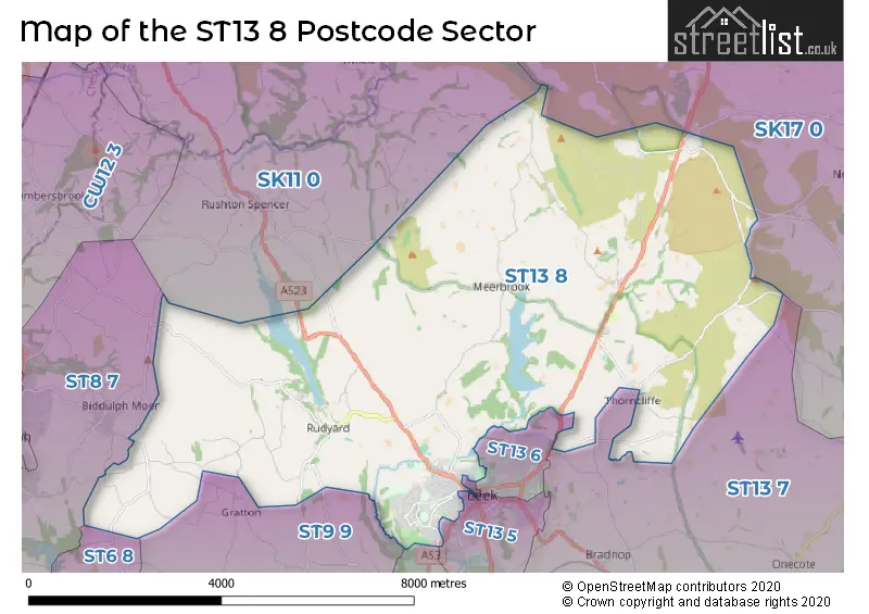
The ST13 8 Postcode shares a border with SK11 0 (Sutton, Rushton Spencer, Langley), ST6 8 (STOKE-ON-TRENT, Brown Edge), ST8 7 (Biddulph, Knypersley, Biddulph Moor), ST13 5 (LEEK), SK17 0 (Longnor, Hartington, Quarnford), ST9 9 (Endon, Stockton Brook, Longsdon), ST13 6 (LEEK) and ST13 7 (Cheddleton, LEEK, Bradnop).
The sector is within the post town of LEEK.
ST13 8 is a postcode sector within the ST13 postcode district which is within the ST Stoke-on-Trent postcode area.
The Royal Mail delivery office for the ST13 8 postal sector is the Leek Delivery Office.
The area of the ST13 8 postcode sector is 27.44 square miles which is 71.06 square kilometres or 17,560.32 square acres.
Waterways within the ST13 8 postcode sector include the River Churnet, Black Brook.

Map of the ST13 8 Postcode Sector
Explore the ST13 8 postcode sector by using our free interactive map.
| S | T | 1 | 3 | - | 8 | X | X |
| S | T | 1 | 3 | Space | 8 | Letter | Letter |
Official List of Streets
LEEK (115 Streets)
Blackshaw Moor (6 Streets)
Horton (5 Streets)
Upper Hulme (1 Streets)
Lask Edge (4 Streets)
Unofficial Streets or Alternative Spellings
LEEK
BRITANNIA STREET BROW HILL CAMPBELL AVENUE CHURCH STREET CLERK BANK DAISY BANK GEOFFREY AVENUE HAWKSWORTH AVENUE HIGH STREET OVERTON BANK SALISBURY STREET SHEEP MARKET STANLEY STREET STRANGMAN STREET SUNNYHILLS ROAD WALLBRIDGE PRECINCT WESTCLIFFE WESTWOOD TERRACEWarslow
LEEK ROADLongnor
LEEK ROADBosley
MACCLESFIELD ROADBiddulph Moor
BARRAGE ROAD CROWBOROUGH ROAD LEEK LANEEndon
DAMS LANE DUNWOOD LANE HATHAWAY LANEWeather Forecast for ST13 8
Press Button to Show Forecast for Meerbrook Youth Hostel
| Time Period | Icon | Description | Temperature | Rain Probability | Wind |
|---|---|---|---|---|---|
| 00:00 to 03:00 | Partly cloudy (night) | 1.0°C (feels like -1.0°C) | 0.00% | W 4 mph | |
| 03:00 to 06:00 | Cloudy | 3.0°C (feels like 0.0°C) | 16.00% | WSW 4 mph | |
| 06:00 to 09:00 | Light rain | 4.0°C (feels like 1.0°C) | 74.00% | WSW 7 mph | |
| 09:00 to 12:00 | Overcast | 5.0°C (feels like 2.0°C) | 48.00% | WNW 11 mph | |
| 12:00 to 15:00 | Light rain | 7.0°C (feels like 4.0°C) | 47.00% | N 9 mph | |
| 15:00 to 18:00 | Cloudy | 7.0°C (feels like 5.0°C) | 8.00% | NNE 7 mph | |
| 18:00 to 21:00 | Cloudy | 6.0°C (feels like 5.0°C) | 7.00% | ESE 4 mph | |
| 21:00 to 00:00 | Cloudy | 4.0°C (feels like 2.0°C) | 5.00% | ENE 4 mph |
Press Button to Show Forecast for Meerbrook Youth Hostel
| Time Period | Icon | Description | Temperature | Rain Probability | Wind |
|---|---|---|---|---|---|
| 00:00 to 03:00 | Partly cloudy (night) | 2.0°C (feels like 0.0°C) | 3.00% | E 7 mph | |
| 03:00 to 06:00 | Partly cloudy (night) | 1.0°C (feels like -2.0°C) | 2.00% | E 4 mph | |
| 06:00 to 09:00 | Partly cloudy (day) | 2.0°C (feels like -1.0°C) | 1.00% | ENE 7 mph | |
| 09:00 to 12:00 | Cloudy | 6.0°C (feels like 4.0°C) | 9.00% | NE 4 mph | |
| 12:00 to 15:00 | Overcast | 7.0°C (feels like 6.0°C) | 10.00% | NE 4 mph | |
| 15:00 to 18:00 | Cloudy | 8.0°C (feels like 7.0°C) | 8.00% | ESE 4 mph | |
| 18:00 to 21:00 | Cloudy | 7.0°C (feels like 6.0°C) | 7.00% | E 4 mph | |
| 21:00 to 00:00 | Partly cloudy (night) | 4.0°C (feels like 0.0°C) | 6.00% | E 7 mph |
Press Button to Show Forecast for Meerbrook Youth Hostel
| Time Period | Icon | Description | Temperature | Rain Probability | Wind |
|---|---|---|---|---|---|
| 00:00 to 03:00 | Partly cloudy (night) | 2.0°C (feels like -1.0°C) | 8.00% | E 7 mph | |
| 03:00 to 06:00 | Partly cloudy (night) | 2.0°C (feels like -1.0°C) | 6.00% | E 7 mph | |
| 06:00 to 09:00 | Cloudy | 3.0°C (feels like 0.0°C) | 9.00% | E 7 mph | |
| 09:00 to 12:00 | Cloudy | 7.0°C (feels like 4.0°C) | 9.00% | E 9 mph | |
| 12:00 to 15:00 | Cloudy | 8.0°C (feels like 6.0°C) | 15.00% | E 9 mph | |
| 15:00 to 18:00 | Overcast | 9.0°C (feels like 6.0°C) | 22.00% | E 11 mph | |
| 18:00 to 21:00 | Cloudy | 8.0°C (feels like 5.0°C) | 17.00% | ENE 11 mph | |
| 21:00 to 00:00 | Cloudy | 5.0°C (feels like 2.0°C) | 15.00% | ENE 11 mph |
Press Button to Show Forecast for Meerbrook Youth Hostel
| Time Period | Icon | Description | Temperature | Rain Probability | Wind |
|---|---|---|---|---|---|
| 00:00 to 03:00 | Light rain | 5.0°C (feels like 1.0°C) | 46.00% | NE 11 mph | |
| 03:00 to 06:00 | Cloudy | 5.0°C (feels like 1.0°C) | 20.00% | NE 11 mph | |
| 06:00 to 09:00 | Heavy rain | 5.0°C (feels like 2.0°C) | 72.00% | NE 11 mph | |
| 09:00 to 12:00 | Heavy rain | 6.0°C (feels like 3.0°C) | 76.00% | NNE 11 mph | |
| 12:00 to 15:00 | Light rain | 8.0°C (feels like 5.0°C) | 54.00% | N 11 mph | |
| 15:00 to 18:00 | Light rain | 8.0°C (feels like 5.0°C) | 54.00% | NNW 11 mph | |
| 18:00 to 21:00 | Light rain shower (day) | 8.0°C (feels like 5.0°C) | 36.00% | NNW 9 mph | |
| 21:00 to 00:00 | Clear night | 6.0°C (feels like 4.0°C) | 12.00% | NW 7 mph |
Schools and Places of Education Within the ST13 8 Postcode Sector
Blackshaw Moor CofE First School
Academy converter
Buxton Road, Leek, Staffordshire, ST13 8TW
Head: Mrs Samantha Crawforth
Ofsted Rating: Good
Inspection: 2023-12-07 (140 days ago)
Website: Visit Blackshaw Moor CofE First School Website
Phone: 01538300337
Number of Pupils: 76
Horton Lodge Community Special School
Community special school
Rudyard, Leek, Staffordshire, ST13 8RB
Head: Mrs Lucy Bloor
Ofsted Rating: Good
Inspection: 2024-01-24 (92 days ago)
Website: Visit Horton Lodge Community Special School Website
Phone: 01538306214
Number of Pupils: 57
St Edward's Church of England Academy
Academy converter
Westwood Road, Leek, Staffordshire, ST13 8DN
Head: Mrs Katie Smith
Ofsted Rating: Requires improvement
Inspection: 2022-02-16 (799 days ago)
Website: Visit St Edward's Church of England Academy Website
Phone: 01538714740
Number of Pupils: 723
St Mary's Catholic Academy
Academy converter
Cruso Street, Leek, Staffordshire, ST13 8BW
Head: Mrs Gemma Turner
Ofsted Rating: Good
Inspection: 2019-12-05 (1603 days ago)
Website: Visit St Mary's Catholic Academy Website
Phone: 01538493888
Number of Pupils: 168
Westwood College
Academy converter
Westwood Park, Leek, Staffordshire, ST13 8NP
Head: Mr Matthew Taylor
Ofsted Rating: Good
Inspection: 2019-02-13 (1898 days ago)
Website: Visit Westwood College Website
Phone: 01538370930
Number of Pupils: 779
Westwood First School
Academy converter
Westwood Road, Leek, Staffordshire, ST13 8DL
Head: Mrs Adele Johnson
Ofsted Rating: Good
Inspection: 2023-09-20 (218 days ago)
Website: Visit Westwood First School Website
Phone: 01538714990
Number of Pupils: 277
House Prices in the ST13 8 Postcode Sector
| Type of Property | 2018 Average | 2018 Sales | 2017 Average | 2017 Sales | 2016 Average | 2016 Sales | 2015 Average | 2015 Sales |
|---|---|---|---|---|---|---|---|---|
| Detached | £312,236 | 27 | £274,388 | 39 | £281,163 | 40 | £231,818 | 45 |
| Semi-Detached | £183,533 | 31 | £165,470 | 45 | £157,998 | 47 | £151,298 | 23 |
| Terraced | £124,296 | 63 | £121,977 | 64 | £116,070 | 61 | £113,325 | 71 |
| Flats | £83,700 | 5 | £88,000 | 1 | £79,931 | 8 | £73,050 | 5 |
Important Postcodes ST13 8 in the Postcode Sector
ST13 8AD is the postcode for H M Revenue & Customs, Britannia Chambers, West Street
ST13 8BW is the postcode for Staffordshire County Council, St. Marys RC Cp School, Cruso Street, ST MARYS CATHOLIC ACADEMY, CRUSO STREET, LEEK, and St Marys Catholic Academy, Cruso Street
ST13 8DL is the postcode for Staffordshire County Council, Westwood County First School, Westwood Road, and WESTWOOD COUNTY FIRST SCHOOL, WESTWOOD ROAD
ST13 8DN is the postcode for St Edward's Church of England Academy, Westwood Road, and St EdwardG��s Church of England Academy, Westwood Road
ST13 8JG is the postcode for Staffordshire County Council, Woodcroft County First School, Wallbridge Drive, and Woodcroft Academy, Wallbridge Drive, Leek
ST13 8NP is the postcode for Westwood College, Westwood Park Drive, NEW HALL, Westwood College, Westwood Park Drive, ENGLISH BLOCK, Westwood College, Westwood Park Drive, MUSIC BLOCK, Westwood College, Westwood Park Drive, Staffordshire County Council, Westwood High School, Westwood Park Drive, and OLD HALL, Westwood College, Westwood Park Drive
ST13 8RB is the postcode for HORTON LODGE SCHOOL, REACLIFFE ROAD, and Staffordshire County Council, Horton Lodge Special School,
ST13 8RU is the postcode for Staffordshire County Council, St. Michaels First School
ST13 8TW is the postcode for Blackshaw Moor C of E First School, Buxton Road
| The ST13 8 Sector is within these Local Authorities |
|
|---|---|
| The ST13 8 Sector is within these Counties |
|
| The ST13 8 Sector is within these Water Company Areas |
|