The ST5 4 postcode sector is within the county of Staffordshire.
Did you know? According to the 2021 Census, the ST5 4 postcode sector is home to a bustling 6,103 residents!
Given that each sector allows for 400 unique postcode combinations. Letters C, I, K, M, O and V are not allowed in the last two letters of a postcode. With 140 postcodes already in use, this leaves 260 units available.
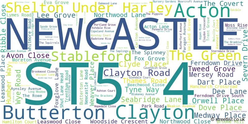
The largest settlement in the ST5 4 postal code is NEWCASTLE followed by Butterton, and Acton.
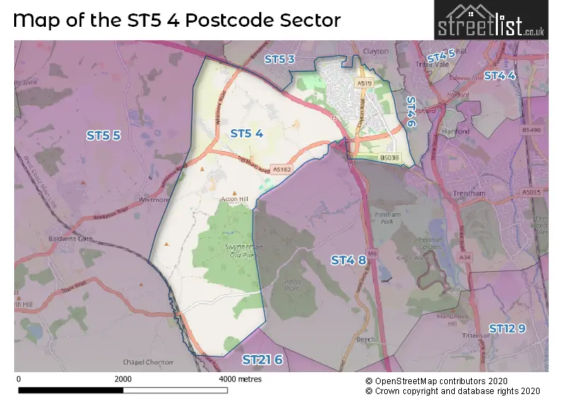
The ST5 4 Postcode shares a border with ST4 6 (STOKE-ON-TRENT), ST4 8 (STOKE-ON-TRENT, Trentham, Beech), ST5 2 (NEWCASTLE), ST5 3 (NEWCASTLE), ST5 5 (Keele, Baldwins Gate, Whitmore) and ST21 6 (Eccleshall, Cotes Heath, Standon).
The sector is within the post town of NEWCASTLE.
ST5 4 is a postcode sector within the ST5 postcode district which is within the ST Stoke-on-Trent postcode area.
The Royal Mail delivery office for the ST5 4 postal sector is the Newcastle Under Lyme Delivery Office.
The area of the ST5 4 postcode sector is 5.16 square miles which is 13.37 square kilometres or 3,304.51 square acres.
The ST5 4 postcode sector is crossed by the A500 Major A road.
The ST5 4 postcode sector is crossed by the M6 motorway.

Map of the ST5 4 Postcode Sector
Explore the ST5 4 postcode sector by using our free interactive map.
| S | T | 5 | - | 4 | X | X |
| S | T | 5 | Space | 4 | Letter | Letter |
Official List of Streets
Acton (3 Streets)
NEWCASTLE (103 Streets)
Clayton (2 Streets)
Butterton (6 Streets)
Unofficial Streets or Alternative Spellings
NEWCASTLE
RYDAL WAY WARWICK AVENUE WAVENEY GROVEHanchurch
DRAYTON ROAD HANCHURCH FIELDS PEACOCK LANE ACTON ROAD BENT LANE BUTTERTON ROAD COMMON LANE DALTRY PLACE DOG LANE DOG ROSE LANE HANCHURCH ROUNDABOUT NORTHWOOD GARDEN CENTRE STABLEFORD BRIDGE SWYNNERTON FP4 SWYNNERTON FP5(A) SWYNNERTON FP5(B) WHITE HOUSEButterton
NURSERY GARDENSNEWCASTLE,
CLAYTON LANESTOKE-ON-TRENT
WHITMORE ROADBlackbrook
STONE ROADWeather Forecast for ST5 4
Press Button to Show Forecast for Whitmore Hall
| Time Period | Icon | Description | Temperature | Rain Probability | Wind |
|---|---|---|---|---|---|
| 09:00 to 12:00 | Light rain shower (day) | 7.0°C (feels like 4.0°C) | 38.00% | NW 11 mph | |
| 12:00 to 15:00 | Cloudy | 8.0°C (feels like 5.0°C) | 9.00% | NW 11 mph | |
| 15:00 to 18:00 | Cloudy | 8.0°C (feels like 6.0°C) | 36.00% | NNW 7 mph | |
| 18:00 to 21:00 | Cloudy | 7.0°C (feels like 6.0°C) | 8.00% | NE 4 mph | |
| 21:00 to 00:00 | Cloudy | 5.0°C (feels like 3.0°C) | 48.00% | NNE 4 mph |
Press Button to Show Forecast for Whitmore Hall
| Time Period | Icon | Description | Temperature | Rain Probability | Wind |
|---|---|---|---|---|---|
| 00:00 to 03:00 | Cloudy | 4.0°C (feels like 2.0°C) | 6.00% | E 4 mph | |
| 03:00 to 06:00 | Partly cloudy (night) | 2.0°C (feels like 0.0°C) | 2.00% | E 4 mph | |
| 06:00 to 09:00 | Cloudy | 3.0°C (feels like 0.0°C) | 5.00% | E 7 mph | |
| 09:00 to 12:00 | Cloudy | 6.0°C (feels like 4.0°C) | 5.00% | ESE 4 mph | |
| 12:00 to 15:00 | Overcast | 8.0°C (feels like 7.0°C) | 10.00% | ENE 4 mph | |
| 15:00 to 18:00 | Cloudy | 9.0°C (feels like 8.0°C) | 8.00% | E 4 mph | |
| 18:00 to 21:00 | Cloudy | 8.0°C (feels like 7.0°C) | 9.00% | E 4 mph | |
| 21:00 to 00:00 | Partly cloudy (night) | 5.0°C (feels like 2.0°C) | 7.00% | E 9 mph |
Press Button to Show Forecast for Whitmore Hall
| Time Period | Icon | Description | Temperature | Rain Probability | Wind |
|---|---|---|---|---|---|
| 00:00 to 03:00 | Cloudy | 3.0°C (feels like 0.0°C) | 11.00% | E 7 mph | |
| 03:00 to 06:00 | Partly cloudy (night) | 2.0°C (feels like 0.0°C) | 7.00% | E 7 mph | |
| 06:00 to 09:00 | Cloudy | 3.0°C (feels like 1.0°C) | 10.00% | ENE 7 mph | |
| 09:00 to 12:00 | Cloudy | 7.0°C (feels like 5.0°C) | 8.00% | E 9 mph | |
| 12:00 to 15:00 | Cloudy | 9.0°C (feels like 6.0°C) | 16.00% | E 9 mph | |
| 15:00 to 18:00 | Overcast | 10.0°C (feels like 7.0°C) | 21.00% | E 9 mph | |
| 18:00 to 21:00 | Cloudy | 9.0°C (feels like 7.0°C) | 17.00% | ENE 9 mph | |
| 21:00 to 00:00 | Cloudy | 6.0°C (feels like 3.0°C) | 16.00% | ENE 9 mph |
Press Button to Show Forecast for Whitmore Hall
| Time Period | Icon | Description | Temperature | Rain Probability | Wind |
|---|---|---|---|---|---|
| 00:00 to 03:00 | Cloudy | 5.0°C (feels like 2.0°C) | 21.00% | NE 9 mph | |
| 03:00 to 06:00 | Cloudy | 5.0°C (feels like 2.0°C) | 19.00% | NNE 11 mph | |
| 06:00 to 09:00 | Heavy rain | 6.0°C (feels like 2.0°C) | 72.00% | NNE 11 mph | |
| 09:00 to 12:00 | Heavy rain | 7.0°C (feels like 4.0°C) | 76.00% | NNE 13 mph | |
| 12:00 to 15:00 | Heavy rain | 8.0°C (feels like 5.0°C) | 76.00% | N 13 mph | |
| 15:00 to 18:00 | Heavy rain | 9.0°C (feels like 5.0°C) | 74.00% | NNW 13 mph | |
| 18:00 to 21:00 | Cloudy | 9.0°C (feels like 6.0°C) | 18.00% | N 9 mph | |
| 21:00 to 00:00 | Partly cloudy (night) | 6.0°C (feels like 4.0°C) | 10.00% | WNW 7 mph |
Schools and Places of Education Within the ST5 4 Postcode Sector
Our Lady and St Werburgh's Catholic Primary School
Academy converter
Seabridge Lane, Newcastle, Staffordshire, ST5 4AG
Head: Mrs R Wilson
Ofsted Rating: Good
Inspection: 2022-09-15 (588 days ago)
Website: Visit Our Lady and St Werburgh's Catholic Primary School Website
Phone: 01782973888
Number of Pupils: 212
House Prices in the ST5 4 Postcode Sector
| Type of Property | 2018 Average | 2018 Sales | 2017 Average | 2017 Sales | 2016 Average | 2016 Sales | 2015 Average | 2015 Sales |
|---|---|---|---|---|---|---|---|---|
| Detached | £243,765 | 60 | £225,767 | 76 | £221,774 | 65 | £232,021 | 63 |
| Semi-Detached | £161,614 | 37 | £164,996 | 41 | £141,926 | 31 | £153,433 | 23 |
| Terraced | £126,927 | 15 | £115,590 | 10 | £107,246 | 12 | £106,681 | 8 |
| Flats | £62,000 | 1 | £0 | 0 | £0 | 0 | £0 | 0 |
Important Postcodes ST5 4 in the Postcode Sector
ST5 4AG is the postcode for Our Lady And St Werburghs Primary School, Seabridge Lane, Our Lady & St. Werburghs Church, Seabridge Lane, and Staffordshire County Council, Our Lady & St. Werburghs RC Primary School, Seabridge Lane
ST5 4AZ is the postcode for Wye Road Community Centre, Wye Road
ST5 4BN is the postcode for Clayton Community Centre, Northwood Lane
ST5 4DB is the postcode for The North Staffordshire Nuffield Hospital, Clayton Road
| The ST5 4 Sector is within these Local Authorities |
|
|---|---|
| The ST5 4 Sector is within these Counties |
|
| The ST5 4 Sector is within these Water Company Areas |
|