The ST5 7 postcode sector is within the county of Staffordshire.
Did you know? According to the 2021 Census, the ST5 7 postcode sector is home to a bustling 11,209 residents!
Given that each sector allows for 400 unique postcode combinations. Letters C, I, K, M, O and V are not allowed in the last two letters of a postcode. With 240 postcodes already in use, this leaves 160 units available.
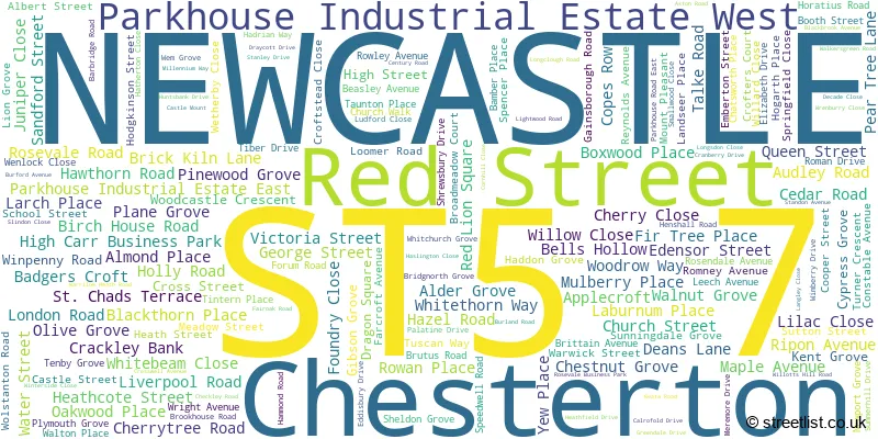
The largest settlement in the ST5 7 postal code is NEWCASTLE followed by Chesterton, and Parkhouse Industrial Estate East.
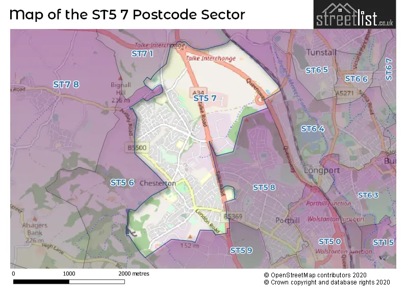
The ST5 7 Postcode shares a border with ST6 4 (STOKE-ON-TRENT), ST7 1 (Talke, Kidsgrove, Talke Pits), ST5 6 (NEWCASTLE, Silverdale, Knutton), ST5 8 (NEWCASTLE, Wolstanton, Porthill) and ST5 9 (NEWCASTLE, Lymedale Business Park, Cross Heath).
The sector is within the post town of NEWCASTLE.
ST5 7 is a postcode sector within the ST5 postcode district which is within the ST Stoke-on-Trent postcode area.
The Royal Mail delivery office for the ST5 7 postal sector is the Newcastle Under Lyme Delivery Office.
The area of the ST5 7 postcode sector is 2.34 square miles which is 6.06 square kilometres or 1,498.58 square acres.
The ST5 7 postcode sector is crossed by the A34 Major A road.
The ST5 7 postcode sector is crossed by the A500 Major A road.

Map of the ST5 7 Postcode Sector
Explore the ST5 7 postcode sector by using our free interactive map.
| S | T | 5 | - | 7 | X | X |
| S | T | 5 | Space | 7 | Letter | Letter |
Official List of Streets
Chesterton (22 Streets)
NEWCASTLE (134 Streets)
Parkhouse Industrial Estate West (5 Streets)
High Carr Business Park (3 Streets)
Red Street (3 Streets)
Parkhouse Industrial Estate East (3 Streets)
Unofficial Streets or Alternative Spellings
NEWCASTLE
APEDALE ROAD BRADWELL LANE CASTLE MOUNT HOLDITCH ROAD MOSS GROVE SPRINGWOOD ROAD BARKER STREET BEASLEY PLACE BRADWELL WOODS BRICK-KILN LANE CEDAR CLOSE CEDAR ROAD ROUNDABOUT CROFTSMEAD CLOSE DIXONS ROW EDENSOR COURT FAIR OAK ROAD GATEWAY KING STREET LONGCLOUGH DRIVE LOOMER ROAD ROUNDABOUT MILLENIUM WAY MOUNT STREET PARKHOUSE ROAD WEST PARKHOUSE ROUNDABOUT PEACOCK HAY ROAD PIT HEAD CLOSE QUEENSWAY REGINALD MITCHELL WAY ROSEVALE COURT TALKE INTERCHANGE THE MOUNT TRINITY COURT VALE STREET VICTORIA PLACE WARRILOWHEATH ROAD WOLSTANTON ROUNDABOUTRowhurst Industrial Estate
WATERMILLS ROADLymedale Business Park
DALEWOOD ROADTalke
NEWCASTLE ROADBradwell
TALKE ROADWeather Forecast for ST5 7
Press Button to Show Forecast for Crackley
| Time Period | Icon | Description | Temperature | Rain Probability | Wind |
|---|---|---|---|---|---|
| 06:00 to 09:00 | Cloudy | 7.0°C (feels like 4.0°C) | 15.00% | NW 16 mph | |
| 09:00 to 12:00 | Overcast | 8.0°C (feels like 5.0°C) | 12.00% | NW 18 mph | |
| 12:00 to 15:00 | Overcast | 10.0°C (feels like 6.0°C) | 15.00% | NNW 18 mph | |
| 15:00 to 18:00 | Cloudy | 10.0°C (feels like 7.0°C) | 13.00% | NNW 16 mph | |
| 18:00 to 21:00 | Cloudy | 9.0°C (feels like 6.0°C) | 9.00% | NNW 9 mph | |
| 21:00 to 00:00 | Cloudy | 6.0°C (feels like 5.0°C) | 5.00% | NNE 4 mph |
Press Button to Show Forecast for Crackley
| Time Period | Icon | Description | Temperature | Rain Probability | Wind |
|---|---|---|---|---|---|
| 00:00 to 03:00 | Partly cloudy (night) | 4.0°C (feels like 3.0°C) | 1.00% | NE 4 mph | |
| 03:00 to 06:00 | Clear night | 3.0°C (feels like 1.0°C) | 1.00% | N 4 mph | |
| 06:00 to 09:00 | Partly cloudy (day) | 3.0°C (feels like 1.0°C) | 2.00% | NNW 4 mph | |
| 09:00 to 12:00 | Partly cloudy (day) | 6.0°C (feels like 4.0°C) | 2.00% | N 7 mph | |
| 12:00 to 15:00 | Overcast | 9.0°C (feels like 7.0°C) | 8.00% | N 7 mph | |
| 15:00 to 18:00 | Overcast | 10.0°C (feels like 9.0°C) | 10.00% | N 7 mph | |
| 18:00 to 21:00 | Cloudy | 10.0°C (feels like 8.0°C) | 5.00% | N 7 mph | |
| 21:00 to 00:00 | Partly cloudy (night) | 7.0°C (feels like 5.0°C) | 2.00% | NNE 4 mph |
Press Button to Show Forecast for Crackley
| Time Period | Icon | Description | Temperature | Rain Probability | Wind |
|---|---|---|---|---|---|
| 00:00 to 03:00 | Partly cloudy (night) | 5.0°C (feels like 4.0°C) | 1.00% | NE 4 mph | |
| 03:00 to 06:00 | Partly cloudy (night) | 4.0°C (feels like 3.0°C) | 2.00% | NNE 4 mph | |
| 06:00 to 09:00 | Cloudy | 5.0°C (feels like 3.0°C) | 7.00% | N 4 mph | |
| 09:00 to 12:00 | Cloudy | 8.0°C (feels like 6.0°C) | 8.00% | N 4 mph | |
| 12:00 to 15:00 | Overcast | 10.0°C (feels like 8.0°C) | 13.00% | NNE 7 mph | |
| 15:00 to 18:00 | Overcast | 11.0°C (feels like 9.0°C) | 11.00% | NE 7 mph | |
| 18:00 to 21:00 | Cloudy | 10.0°C (feels like 8.0°C) | 7.00% | NE 7 mph | |
| 21:00 to 00:00 | Cloudy | 7.0°C (feels like 6.0°C) | 6.00% | ENE 7 mph |
Press Button to Show Forecast for Crackley
| Time Period | Icon | Description | Temperature | Rain Probability | Wind |
|---|---|---|---|---|---|
| 00:00 to 03:00 | Cloudy | 5.0°C (feels like 4.0°C) | 7.00% | ENE 4 mph | |
| 03:00 to 06:00 | Cloudy | 4.0°C (feels like 2.0°C) | 6.00% | NE 4 mph | |
| 06:00 to 09:00 | Cloudy | 5.0°C (feels like 3.0°C) | 7.00% | NE 4 mph | |
| 09:00 to 12:00 | Cloudy | 8.0°C (feels like 6.0°C) | 11.00% | ENE 7 mph | |
| 12:00 to 15:00 | Cloudy | 9.0°C (feels like 7.0°C) | 11.00% | ENE 7 mph | |
| 15:00 to 18:00 | Cloudy | 10.0°C (feels like 8.0°C) | 10.00% | ENE 9 mph | |
| 18:00 to 21:00 | Cloudy | 9.0°C (feels like 7.0°C) | 10.00% | ENE 7 mph | |
| 21:00 to 00:00 | Cloudy | 6.0°C (feels like 5.0°C) | 7.00% | ENE 7 mph |
Schools and Places of Education Within the ST5 7 Postcode Sector
Chesterton Community Sports College
Academy converter
Castle Street, Newcastle, Staffordshire, ST5 7LP
Head: Mr Robert Swindells
Ofsted Rating: Good
Inspection: 2022-09-22 (575 days ago)
Website: Visit Chesterton Community Sports College Website
Phone: 01782568350
Number of Pupils: 883
Chesterton Primary School
Academy converter
Brittain Avenue, Newcastle-Under-Lyme, Staffordshire, ST5 7NT
Head: Ms Helen Swindells
Ofsted Rating: Good
Inspection: 2021-06-09 (1045 days ago)
Website: Visit Chesterton Primary School Website
Phone: 01782568650
Number of Pupils: 175
Churchfields Primary School
Academy sponsor led
School Street, Newcastle, Staffordshire, ST5 7HY
Head: Mrs Diane Beardsmore
Ofsted Rating: Outstanding
Inspection: 2015-07-02 (3214 days ago)
Website: Visit Churchfields Primary School Website
Phone: 01782567430
Number of Pupils: 401
Crackley Bank Primary School
Academy converter
Blackthorn Place, Newcastle, Staffordshire, ST5 7BE
Head: Ms Sara Stevenson
Ofsted Rating: Good
Inspection: 2023-03-22 (394 days ago)
Website: Visit Crackley Bank Primary School Website
Phone: 01782567700
Number of Pupils: 196
St Chad's CofE (C) Primary School
Voluntary controlled school
The Gateway, Newcastle, Staffordshire, ST5 7AB
Head: Mrs Joanne Brennan
Ofsted Rating: Good
Inspection: 2023-05-12 (343 days ago)
Website: Visit St Chad's CofE (C) Primary School Website
Phone: 01782567750
Number of Pupils: 267
House Prices in the ST5 7 Postcode Sector
| Type of Property | 2018 Average | 2018 Sales | 2017 Average | 2017 Sales | 2016 Average | 2016 Sales | 2015 Average | 2015 Sales |
|---|---|---|---|---|---|---|---|---|
| Detached | £212,381 | 40 | £188,664 | 45 | £159,123 | 36 | £165,360 | 42 |
| Semi-Detached | £105,551 | 59 | £109,037 | 62 | £88,147 | 43 | £94,094 | 36 |
| Terraced | £88,501 | 42 | £84,657 | 55 | £81,140 | 61 | £71,848 | 50 |
| Flats | £78,625 | 4 | £71,779 | 7 | £74,000 | 4 | £63,000 | 2 |
Important Postcodes ST5 7 in the Postcode Sector
ST5 7AB is the postcode for St. Chads Primary School, Crackley Bank, and St. Chad's CE(VC) Primary School (Newcastle), The Gateway
ST5 7AH is the postcode for Red Street Community Centre, Talke Road
ST5 7BE is the postcode for Crackley Bank Cp School, Blackthorn Place, and CRACKLEY BANK PRIMARY SCHOOL, CRACKLEY BANK
ST5 7DJ is the postcode for Crackley Community Centre, 8 Holly Road
ST5 7EB is the postcode for The Surgery, 2 Heathcote Street
ST5 7HL is the postcode for SPECIALIST CHILDRENS SHORT STAY SERVICE, Dragon Square Community Unit, 1 Dragon Square
ST5 7HY is the postcode for CHURCHFIELDS PRIMARY SCHOOL, SCHOOL STREET, CHESTERTON, and Staffordshire County Council, Churchfields Cp School, School Street
ST5 7HZ is the postcode for Chesterton Community Centre, 183 London Road
ST5 7JF is the postcode for Chesterton Vision Centre, Albert Street, and Chesterton Vision Centre, Albert Street, Chesterton
ST5 7JS is the postcode for Chesterton Clinic, Loomer Road, and Loomer Road Surgery, Loomer Road
ST5 7LP is the postcode for Chesterton Community Sports College, Castle Street, Chesterton Community Sports College, Castle Street, Chesterton, and SPORTS CENTRE, Chesterton Community Sports College, Castle Street
ST5 7NJ is the postcode for North Staffordshire PCT, Bradwell Hospital (PCT HQ), Bradwell Hospital, Talke Road, Chesterton, North Staffordshire Combined Healthcare NHS Trust, Bradwell Hospital (rly), and Bradwell Hospital, Talke Road
ST5 7NT is the postcode for Chesterton Primary School, Brittain Avenue
ST5 7RT is the postcode for Newcastle Business Centre, Newcastle Business Centre, Winpenny Road
ST5 7TL is the postcode for Lymebrook Mental Health Centre, Bradwell Hospital, Talke Road
| The ST5 7 Sector is within these Local Authorities |
|
|---|---|
| The ST5 7 Sector is within these Counties |
|
| The ST5 7 Sector is within these Water Company Areas |
|