The ST5 8 postcode sector is within the county of Staffordshire.
Did you know? According to the 2021 Census, the ST5 8 postcode sector is home to a bustling 10,775 residents!
Given that each sector allows for 400 unique postcode combinations. Letters C, I, K, M, O and V are not allowed in the last two letters of a postcode. With 218 postcodes already in use, this leaves 182 units available.
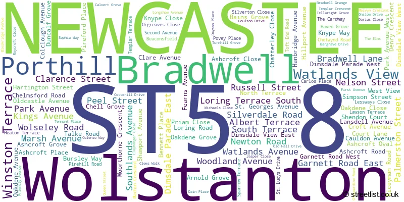
The largest settlement in the ST5 8 postal code is NEWCASTLE followed by Wolstanton, and Porthill.
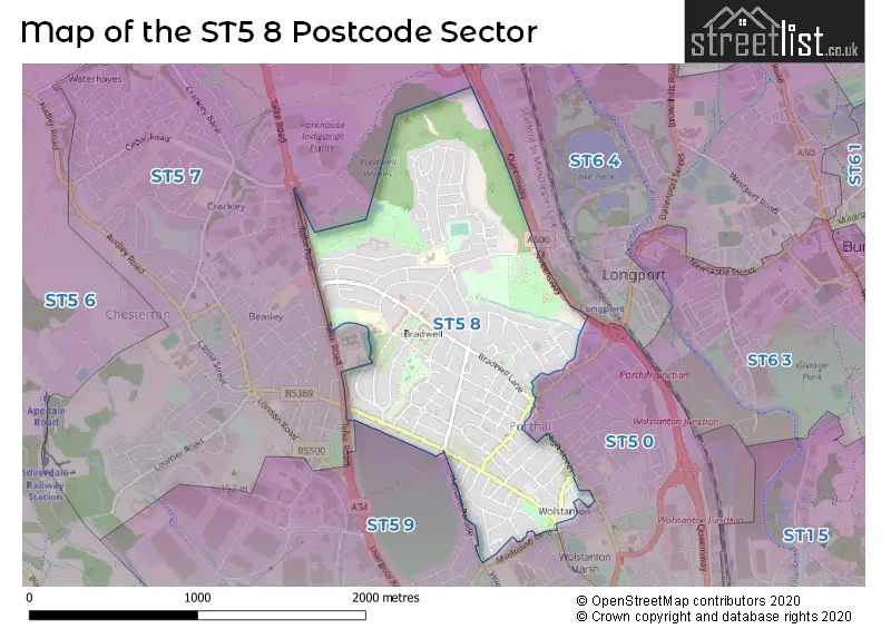
The ST5 8 Postcode shares a border with ST6 4 (STOKE-ON-TRENT), ST5 0 (NEWCASTLE, Wolstanton, May Bank), ST5 7 (NEWCASTLE, Chesterton, Parkhouse Industrial Estate East) and ST5 9 (NEWCASTLE, Lymedale Business Park, Cross Heath).
The sector is within the post town of NEWCASTLE.
ST5 8 is a postcode sector within the ST5 postcode district which is within the ST Stoke-on-Trent postcode area.
The Royal Mail delivery office for the ST5 8 postal sector is the Newcastle Under Lyme Delivery Office.
The area of the ST5 8 postcode sector is 0.99 square miles which is 2.58 square kilometres or 636.43 square acres.
The ST5 8 postcode sector is crossed by the A500 Major A road.

Map of the ST5 8 Postcode Sector
Explore the ST5 8 postcode sector by using our free interactive map.
| S | T | 5 | - | 8 | X | X |
| S | T | 5 | Space | 8 | Letter | Letter |
Official List of Streets
NEWCASTLE (110 Streets)
Wolstanton (3 Streets)
Porthill (1 Streets)
Bradwell (1 Streets)
Unofficial Streets or Alternative Spellings
NEWCASTLE
ALEXANDRA ROAD BEASLEY AVENUE BOULTON STREET HASSAM PARADE JAMES STREET KNUTTON ROAD LODGE GROVE MILEHOUSE LANE PITGREEN LANE PORTHILL BANK WELLINGTON STREET CARDWAY FIX ME MARSH WAY PARKHOUSE ROUNDABOUT PORTHILL ROUNDABOUT PORTLAND MEWS QUEENSWAY SAINT GEORGES AVENUE NORTH SAINT GEORGES AVENUE SOUTH SAINT GEORGES AVENUE WEST SAINT LUCYS DRIVE ST GEORGES AVENUE NORTH ST GEORGES AVENUE SOUTH ST GEORGES AVENUE WEST THE BEECHES THE LIMES WOLSTANTON ROUNDABOUTWolstanton
EMBERTON STREET HIGH STREETParkhouse Industrial Estate East
WINPENNY ROADWeather Forecast for ST5 8
Press Button to Show Forecast for Longbridge Hayes
| Time Period | Icon | Description | Temperature | Rain Probability | Wind |
|---|---|---|---|---|---|
| 09:00 to 12:00 | Cloudy | 6.0°C (feels like 3.0°C) | 14.00% | NW 11 mph | |
| 12:00 to 15:00 | Cloudy | 8.0°C (feels like 5.0°C) | 45.00% | N 9 mph | |
| 15:00 to 18:00 | Cloudy | 8.0°C (feels like 6.0°C) | 33.00% | NW 7 mph | |
| 18:00 to 21:00 | Cloudy | 7.0°C (feels like 6.0°C) | 30.00% | NE 4 mph | |
| 21:00 to 00:00 | Cloudy | 5.0°C (feels like 3.0°C) | 47.00% | ESE 4 mph |
Press Button to Show Forecast for Longbridge Hayes
| Time Period | Icon | Description | Temperature | Rain Probability | Wind |
|---|---|---|---|---|---|
| 00:00 to 03:00 | Partly cloudy (night) | 4.0°C (feels like 2.0°C) | 3.00% | E 4 mph | |
| 03:00 to 06:00 | Partly cloudy (night) | 2.0°C (feels like 0.0°C) | 2.00% | E 7 mph | |
| 06:00 to 09:00 | Partly cloudy (day) | 3.0°C (feels like 0.0°C) | 2.00% | E 7 mph | |
| 09:00 to 12:00 | Cloudy | 6.0°C (feels like 5.0°C) | 5.00% | ESE 4 mph | |
| 12:00 to 15:00 | Overcast | 8.0°C (feels like 7.0°C) | 10.00% | E 4 mph | |
| 15:00 to 18:00 | Cloudy | 9.0°C (feels like 8.0°C) | 10.00% | E 4 mph | |
| 18:00 to 21:00 | Cloudy | 8.0°C (feels like 7.0°C) | 8.00% | E 4 mph | |
| 21:00 to 00:00 | Partly cloudy (night) | 5.0°C (feels like 2.0°C) | 7.00% | E 7 mph |
Press Button to Show Forecast for Longbridge Hayes
| Time Period | Icon | Description | Temperature | Rain Probability | Wind |
|---|---|---|---|---|---|
| 00:00 to 03:00 | Cloudy | 3.0°C (feels like 0.0°C) | 11.00% | E 7 mph | |
| 03:00 to 06:00 | Cloudy | 2.0°C (feels like 0.0°C) | 9.00% | E 7 mph | |
| 06:00 to 09:00 | Cloudy | 3.0°C (feels like 1.0°C) | 9.00% | ENE 7 mph | |
| 09:00 to 12:00 | Cloudy | 7.0°C (feels like 4.0°C) | 9.00% | E 9 mph | |
| 12:00 to 15:00 | Cloudy | 9.0°C (feels like 6.0°C) | 18.00% | E 9 mph | |
| 15:00 to 18:00 | Cloudy | 9.0°C (feels like 7.0°C) | 18.00% | E 9 mph | |
| 18:00 to 21:00 | Cloudy | 9.0°C (feels like 7.0°C) | 18.00% | ENE 9 mph | |
| 21:00 to 00:00 | Cloudy | 6.0°C (feels like 3.0°C) | 16.00% | ENE 9 mph |
Press Button to Show Forecast for Longbridge Hayes
| Time Period | Icon | Description | Temperature | Rain Probability | Wind |
|---|---|---|---|---|---|
| 00:00 to 03:00 | Cloudy | 5.0°C (feels like 2.0°C) | 20.00% | NE 9 mph | |
| 03:00 to 06:00 | Overcast | 6.0°C (feels like 2.0°C) | 23.00% | NNE 11 mph | |
| 06:00 to 09:00 | Heavy rain | 6.0°C (feels like 2.0°C) | 71.00% | NNE 11 mph | |
| 09:00 to 12:00 | Heavy rain | 7.0°C (feels like 3.0°C) | 77.00% | NNE 11 mph | |
| 12:00 to 15:00 | Heavy rain | 8.0°C (feels like 5.0°C) | 76.00% | N 11 mph | |
| 15:00 to 18:00 | Heavy rain | 9.0°C (feels like 5.0°C) | 72.00% | N 11 mph | |
| 18:00 to 21:00 | Cloudy | 9.0°C (feels like 6.0°C) | 19.00% | N 9 mph | |
| 21:00 to 00:00 | Clear night | 6.0°C (feels like 4.0°C) | 11.00% | WNW 7 mph |
Schools and Places of Education Within the ST5 8 Postcode Sector
Bursley Academy
Academy converter
Bursley Way, Newcastle, Staffordshire, ST5 8JQ
Head: Mr John Brian Wilkinson
Ofsted Rating: Outstanding
Inspection: 2012-05-17 (4361 days ago)
Website: Visit Bursley Academy Website
Phone: 01782567740
Number of Pupils: 343
Sun Academy Bradwell
Academy converter
Cauldon Avenue, Newcastle-Under-Lyme, Staffordshire, ST5 8JN
Head: Mrs Laura Niemczyk
Ofsted Rating: Good
Inspection: 2018-07-11 (2115 days ago)
Website: Visit Sun Academy Bradwell Website
Phone: 01782973855
Number of Pupils: 182
House Prices in the ST5 8 Postcode Sector
| Type of Property | 2018 Average | 2018 Sales | 2017 Average | 2017 Sales | 2016 Average | 2016 Sales | 2015 Average | 2015 Sales |
|---|---|---|---|---|---|---|---|---|
| Detached | £207,598 | 20 | £200,933 | 24 | £192,545 | 31 | £190,979 | 14 |
| Semi-Detached | £136,137 | 89 | £135,371 | 106 | £134,467 | 101 | £126,119 | 88 |
| Terraced | £105,338 | 57 | £101,806 | 41 | £105,387 | 55 | £95,065 | 71 |
| Flats | £81,854 | 14 | £65,500 | 2 | £93,994 | 9 | £72,500 | 2 |
Important Postcodes ST5 8 in the Postcode Sector
ST5 8BN is the postcode for Wolstanton Medical Centre, Palmerston Street
ST5 8JN is the postcode for Sun Academy Bradwell, Cauldon Avenue
ST5 8JQ is the postcode for Bursley Academy, Bursley Way
ST5 8LE is the postcode for Bradwell Crematorium, Chatterley Close
ST5 8LF is the postcode for Staffordshire County Council, Bradwell Community Education Centre, Riceyman Road
ST5 8PS is the postcode for Bradwell Lodge Community Centre, Bradwell Lane
| The ST5 8 Sector is within these Local Authorities |
|
|---|---|
| The ST5 8 Sector is within these Counties |
|
| The ST5 8 Sector is within these Water Company Areas |
|