The ST6 3 postcode sector is within the county of Staffordshire.
Did you know? According to the 2021 Census, the ST6 3 postcode sector is home to a bustling 3,975 residents!
Given that each sector allows for 400 unique postcode combinations. Letters C, I, K, M, O and V are not allowed in the last two letters of a postcode. With 141 postcodes already in use, this leaves 259 units available.
The ST6 3 postal code covers the settlement of STOKE-ON-TRENT.
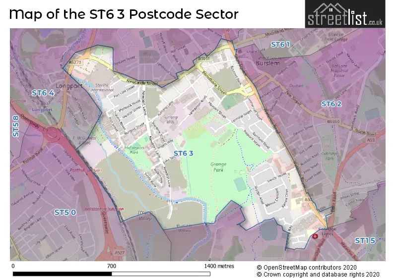
The ST6 3 Postcode shares a border with ST6 2 (STOKE-ON-TRENT, Hot Lane Industrial Estate), ST1 5 (STOKE-ON-TRENT), ST6 1 (STOKE-ON-TRENT, Smallthorne), ST6 4 (STOKE-ON-TRENT) and ST5 0 (NEWCASTLE, Wolstanton, May Bank).
The sector is within the post town of STOKE-ON-TRENT.
ST6 3 is a postcode sector within the ST6 postcode district which is within the ST Stoke-on-Trent postcode area.
The Royal Mail delivery office for the ST6 3 postal sector is the Burslem Delivery Office.
The area of the ST6 3 postcode sector is 0.60 square miles which is 1.56 square kilometres or 384.52 square acres.
Waterways within the ST6 3 postcode sector include the Trent & Mersey Canal.

Map of the ST6 3 Postcode Sector
Explore the ST6 3 postcode sector by using our free interactive map.
| S | T | 6 | - | 3 | X | X |
| S | T | 6 | Space | 3 | Letter | Letter |
Official List of Streets
STOKE-ON-TRENT (87 Streets)
Unofficial Streets or Alternative Spellings
STOKE-ON-TRENT
AITKEN STREET AUCKLAND STREET BLAKE STREET BULSTRODE STREET CHAPEL LANE CHURCH TERRACE DALE STREET DAVENPORT STREET ELDER ROAD ELLGREAVE STREET GLENDALE STREET GLOBE STREET GRANGE STREET LYNDHURST STREET MOORLAND ROAD NEWPORT STREET ORME STREET PITT STREET EAST REMER STREET RILEY STREET SOUTH STEVENTON PLACE WEDGWOOD STREET WESTPORT ROAD BOURNES BANK SOUTH BRICK HOUSE STREET BRIDGEWATER STREET CLAYHANGER STREET EAST VIEW ESSWAYS WALK EYRE STREET KEATES STREET LOWER STREET NEPHEW STREET PACK HORSE LANE PIDDUCK STREET SAINT JOHNS SQUARE SAINT PAUL STREET SHIRLEY STREET ST PAUL STREET STADIUM COURT STEELITE BRIDGE STROMA CLOSE STUBBS STREET SWAINSLEY CLOSE TRAVERS STREET TRUBSHAWE STREET ZION STREETWeather Forecast for ST6 3
Press Button to Show Forecast for Burslem
| Time Period | Icon | Description | Temperature | Rain Probability | Wind |
|---|---|---|---|---|---|
| 12:00 to 15:00 | Cloudy | 9.0°C (feels like 7.0°C) | 3.00% | N 9 mph | |
| 15:00 to 18:00 | Cloudy | 10.0°C (feels like 9.0°C) | 3.00% | NNW 7 mph | |
| 18:00 to 21:00 | Partly cloudy (day) | 9.0°C (feels like 7.0°C) | 1.00% | NW 9 mph | |
| 21:00 to 00:00 | Partly cloudy (night) | 6.0°C (feels like 4.0°C) | 1.00% | NW 4 mph |
Press Button to Show Forecast for Burslem
| Time Period | Icon | Description | Temperature | Rain Probability | Wind |
|---|---|---|---|---|---|
| 00:00 to 03:00 | Partly cloudy (night) | 5.0°C (feels like 3.0°C) | 1.00% | WNW 4 mph | |
| 03:00 to 06:00 | Cloudy | 4.0°C (feels like 2.0°C) | 4.00% | W 7 mph | |
| 06:00 to 09:00 | Cloudy | 5.0°C (feels like 2.0°C) | 6.00% | W 7 mph | |
| 09:00 to 12:00 | Cloudy | 7.0°C (feels like 5.0°C) | 10.00% | NW 11 mph | |
| 12:00 to 15:00 | Cloudy | 9.0°C (feels like 7.0°C) | 10.00% | NW 11 mph | |
| 15:00 to 18:00 | Cloudy | 10.0°C (feels like 8.0°C) | 8.00% | NW 11 mph | |
| 18:00 to 21:00 | Cloudy | 9.0°C (feels like 7.0°C) | 6.00% | NNW 7 mph | |
| 21:00 to 00:00 | Cloudy | 6.0°C (feels like 5.0°C) | 6.00% | NE 4 mph |
Press Button to Show Forecast for Burslem
| Time Period | Icon | Description | Temperature | Rain Probability | Wind |
|---|---|---|---|---|---|
| 00:00 to 03:00 | Cloudy | 5.0°C (feels like 3.0°C) | 7.00% | ESE 7 mph | |
| 03:00 to 06:00 | Cloudy | 4.0°C (feels like 1.0°C) | 8.00% | ESE 7 mph | |
| 06:00 to 09:00 | Cloudy | 4.0°C (feels like 2.0°C) | 10.00% | ENE 7 mph | |
| 09:00 to 12:00 | Cloudy | 6.0°C (feels like 4.0°C) | 10.00% | E 9 mph | |
| 12:00 to 15:00 | Overcast | 8.0°C (feels like 6.0°C) | 14.00% | ESE 9 mph | |
| 15:00 to 18:00 | Overcast | 9.0°C (feels like 7.0°C) | 15.00% | ESE 9 mph | |
| 18:00 to 21:00 | Cloudy | 9.0°C (feels like 6.0°C) | 16.00% | ESE 9 mph | |
| 21:00 to 00:00 | Cloudy | 7.0°C (feels like 4.0°C) | 17.00% | E 9 mph |
Press Button to Show Forecast for Burslem
| Time Period | Icon | Description | Temperature | Rain Probability | Wind |
|---|---|---|---|---|---|
| 00:00 to 03:00 | Cloudy | 6.0°C (feels like 3.0°C) | 21.00% | E 9 mph | |
| 03:00 to 06:00 | Cloudy | 5.0°C (feels like 2.0°C) | 19.00% | E 9 mph | |
| 06:00 to 09:00 | Light rain | 5.0°C (feels like 3.0°C) | 48.00% | E 9 mph | |
| 09:00 to 12:00 | Light rain | 8.0°C (feels like 5.0°C) | 47.00% | E 9 mph | |
| 12:00 to 15:00 | Cloudy | 9.0°C (feels like 7.0°C) | 17.00% | E 9 mph | |
| 15:00 to 18:00 | Light rain shower (day) | 11.0°C (feels like 8.0°C) | 46.00% | ENE 9 mph | |
| 18:00 to 21:00 | Cloudy | 10.0°C (feels like 8.0°C) | 17.00% | ENE 9 mph | |
| 21:00 to 00:00 | Cloudy | 8.0°C (feels like 6.0°C) | 16.00% | NE 9 mph |
House Prices in the ST6 3 Postcode Sector
| Type of Property | 2018 Average | 2018 Sales | 2017 Average | 2017 Sales | 2016 Average | 2016 Sales | 2015 Average | 2015 Sales |
|---|---|---|---|---|---|---|---|---|
| Detached | £203,333 | 3 | £119,000 | 1 | £137,400 | 5 | £143,500 | 1 |
| Semi-Detached | £106,313 | 8 | £111,786 | 7 | £95,767 | 9 | £113,582 | 23 |
| Terraced | £73,647 | 29 | £67,208 | 24 | £70,693 | 35 | £66,298 | 30 |
| Flats | £63,333 | 3 | £83,317 | 3 | £65,000 | 1 | £0 | 0 |
Important Postcodes ST6 3 in the Postcode Sector
ST6 3HL is the postcode for MAIN SCHOOL BLOCK, St. Peters RC Primary School, Waterloo Road, and St. Peters RC Primary School, Waterloo Road
ST6 3NP is the postcode for Middleport Medical Centre, Newport Lane
ST6 3PN is the postcode for NHS Middleport Medical Centre, Woolrich Street
| The ST6 3 Sector is within these Local Authorities |
|
|---|---|
| The ST6 3 Sector is within these Counties |
|
| The ST6 3 Sector is within these Water Company Areas |
|