The ST6 7 postcode sector is within the county of Staffordshire.
Did you know? According to the 2021 Census, the ST6 7 postcode sector is home to a bustling 9,021 residents!
Given that each sector allows for 400 unique postcode combinations. Letters C, I, K, M, O and V are not allowed in the last two letters of a postcode. With 180 postcodes already in use, this leaves 220 units available.
The largest settlements in the ST6 7 postal code are STOKE-ON-TRENT and Burslem.
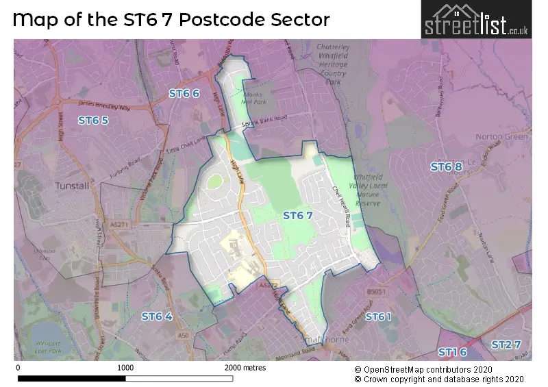
The ST6 7 Postcode shares a border with ST6 1 (STOKE-ON-TRENT, Smallthorne), ST6 4 (STOKE-ON-TRENT), ST6 8 (STOKE-ON-TRENT, Brown Edge) and ST6 6 (STOKE-ON-TRENT).
The sector is within the post town of STOKE-ON-TRENT.
ST6 7 is a postcode sector within the ST6 postcode district which is within the ST Stoke-on-Trent postcode area.
The Royal Mail delivery office for the ST6 7 postal sector is the Burslem Delivery Office.
The area of the ST6 7 postcode sector is 0.92 square miles which is 2.38 square kilometres or 587.58 square acres.

Map of the ST6 7 Postcode Sector
Explore the ST6 7 postcode sector by using our free interactive map.
| S | T | 6 | - | 7 | X | X |
| S | T | 6 | Space | 7 | Letter | Letter |
Official List of Streets
STOKE-ON-TRENT (110 Streets)
Burslem (2 Streets)
Unofficial Streets or Alternative Spellings
STOKE-ON-TRENT
DARTMOUTH STREET DOGCROFT ROAD FELL STREET HAMIL ROAD LITTLE CHELL LANE MACCLESFIELD STREET MOORLAND ROAD SCOTT ROAD SHAFTESBURY AVENUE SPROSTON ROAD SUNNYSIDE AVENUE VICKERS ROADBrindley Ford
BIDDULPH ROAD BANKHOUSE GARDENS BIDDULPH WAY GLYN PLACE HIGH BANK PLACE QUEENS AVENUE REEVES AVENUE SPRINK BANK ROAD SUNNYBANK COURT WEAVENEY WALK SOUTHWeather Forecast for ST6 7
Press Button to Show Forecast for Stanfield
| Time Period | Icon | Description | Temperature | Rain Probability | Wind |
|---|---|---|---|---|---|
| 06:00 to 09:00 | Cloudy | 4.0°C (feels like 2.0°C) | 44.00% | W 7 mph | |
| 09:00 to 12:00 | Cloudy | 6.0°C (feels like 3.0°C) | 31.00% | NW 9 mph | |
| 12:00 to 15:00 | Light rain | 8.0°C (feels like 5.0°C) | 52.00% | N 9 mph | |
| 15:00 to 18:00 | Overcast | 8.0°C (feels like 6.0°C) | 11.00% | NW 7 mph | |
| 18:00 to 21:00 | Cloudy | 7.0°C (feels like 6.0°C) | 30.00% | N 4 mph | |
| 21:00 to 00:00 | Cloudy | 5.0°C (feels like 3.0°C) | 6.00% | NNE 4 mph |
Press Button to Show Forecast for Stanfield
| Time Period | Icon | Description | Temperature | Rain Probability | Wind |
|---|---|---|---|---|---|
| 00:00 to 03:00 | Cloudy | 4.0°C (feels like 2.0°C) | 6.00% | E 7 mph | |
| 03:00 to 06:00 | Partly cloudy (night) | 2.0°C (feels like 0.0°C) | 1.00% | E 7 mph | |
| 06:00 to 09:00 | Cloudy | 3.0°C (feels like 0.0°C) | 4.00% | E 4 mph | |
| 09:00 to 12:00 | Cloudy | 6.0°C (feels like 5.0°C) | 6.00% | ESE 4 mph | |
| 12:00 to 15:00 | Overcast | 8.0°C (feels like 7.0°C) | 10.00% | ESE 4 mph | |
| 15:00 to 18:00 | Cloudy | 9.0°C (feels like 8.0°C) | 10.00% | E 4 mph | |
| 18:00 to 21:00 | Cloudy | 8.0°C (feels like 7.0°C) | 8.00% | E 4 mph | |
| 21:00 to 00:00 | Partly cloudy (night) | 5.0°C (feels like 2.0°C) | 7.00% | E 7 mph |
Press Button to Show Forecast for Stanfield
| Time Period | Icon | Description | Temperature | Rain Probability | Wind |
|---|---|---|---|---|---|
| 00:00 to 03:00 | Cloudy | 3.0°C (feels like 0.0°C) | 11.00% | E 7 mph | |
| 03:00 to 06:00 | Cloudy | 2.0°C (feels like 0.0°C) | 9.00% | E 7 mph | |
| 06:00 to 09:00 | Cloudy | 3.0°C (feels like 1.0°C) | 9.00% | ENE 7 mph | |
| 09:00 to 12:00 | Cloudy | 7.0°C (feels like 4.0°C) | 9.00% | E 9 mph | |
| 12:00 to 15:00 | Cloudy | 9.0°C (feels like 6.0°C) | 18.00% | E 9 mph | |
| 15:00 to 18:00 | Cloudy | 9.0°C (feels like 7.0°C) | 18.00% | E 9 mph | |
| 18:00 to 21:00 | Cloudy | 9.0°C (feels like 7.0°C) | 18.00% | ENE 9 mph | |
| 21:00 to 00:00 | Cloudy | 6.0°C (feels like 3.0°C) | 16.00% | ENE 9 mph |
Press Button to Show Forecast for Stanfield
| Time Period | Icon | Description | Temperature | Rain Probability | Wind |
|---|---|---|---|---|---|
| 00:00 to 03:00 | Cloudy | 5.0°C (feels like 2.0°C) | 20.00% | NE 9 mph | |
| 03:00 to 06:00 | Overcast | 6.0°C (feels like 2.0°C) | 23.00% | NNE 11 mph | |
| 06:00 to 09:00 | Heavy rain | 6.0°C (feels like 3.0°C) | 71.00% | NNE 11 mph | |
| 09:00 to 12:00 | Heavy rain | 7.0°C (feels like 3.0°C) | 77.00% | NNE 11 mph | |
| 12:00 to 15:00 | Heavy rain | 8.0°C (feels like 5.0°C) | 76.00% | N 11 mph | |
| 15:00 to 18:00 | Heavy rain | 9.0°C (feels like 6.0°C) | 72.00% | N 11 mph | |
| 18:00 to 21:00 | Cloudy | 9.0°C (feels like 7.0°C) | 19.00% | N 9 mph | |
| 21:00 to 00:00 | Clear night | 6.0°C (feels like 4.0°C) | 11.00% | WNW 7 mph |
Schools and Places of Education Within the ST6 7 Postcode Sector
Burnwood Community Primary School
Community school
Chell Heath Road, Stoke-on-Trent, Staffordshire, ST6 7LP
Head: Mrs Emma Wickham
Ofsted Rating: Good
Inspection: 2019-11-21 (1617 days ago)
Website: Visit Burnwood Community Primary School Website
Phone: 01782235577
Number of Pupils: 577
Haywood Academy
Academy converter
High Lane, Stoke-on-Trent, Staffordshire, ST6 7AB
Head: Miss Adele Mills
Ofsted Rating: Good
Inspection: 2023-04-20 (371 days ago)
Website: Visit Haywood Academy Website
Phone: 01782853535
Number of Pupils: 1154
House Prices in the ST6 7 Postcode Sector
| Type of Property | 2018 Average | 2018 Sales | 2017 Average | 2017 Sales | 2016 Average | 2016 Sales | 2015 Average | 2015 Sales |
|---|---|---|---|---|---|---|---|---|
| Detached | £157,884 | 25 | £156,276 | 36 | £146,613 | 22 | £125,529 | 34 |
| Semi-Detached | £108,774 | 75 | £103,921 | 68 | £114,000 | 58 | £100,621 | 58 |
| Terraced | £91,931 | 21 | £85,661 | 9 | £78,581 | 21 | £89,197 | 17 |
| Flats | £79,250 | 2 | £95,000 | 2 | £0 | 0 | £75,500 | 5 |
Important Postcodes ST6 7 in the Postcode Sector
ST6 7AB is the postcode for Haywood Academy, High Lane
ST6 7AG is the postcode for The Haywood Hospital, High Lane, and MIdlands Partnership NHS Foundation Trust, Haywood Hospital, High Lane
ST6 7LP is the postcode for MAIN SCHOOL BLOCK, Burnwood Community School, Chell Heath Road, BUILDING 2, Burnwood Community School, Chell Heath Road, and Burnwood Community School, Chell Heath Road
ST6 7NN is the postcode for Brook Medical Centre, Chell Heath Road
| The ST6 7 Sector is within these Local Authorities |
|
|---|---|
| The ST6 7 Sector is within these Counties |
|
| The ST6 7 Sector is within these Water Company Areas |
|