The SW17 7 postcode sector is within the county of Greater London.
Did you know? According to the 2021 Census, the SW17 7 postcode sector is home to a bustling 12,613 residents!
Given that each sector allows for 400 unique postcode combinations. Letters C, I, K, M, O and V are not allowed in the last two letters of a postcode. With 214 postcodes already in use, this leaves 186 units available.
The SW17 7 postal code covers the settlement of LONDON .
The SW17 7 Postcode shares a border with SW11 6 (LONDON ), SW12 8 (LONDON ), SW17 0 (LONDON ), SW17 8 (LONDON ), SW18 3 (LONDON ) and SW12 9 (LONDON ).
The sector is within the post town of LONDON.
SW17 7 is a postcode sector within the SW17 postcode district which is within the SW South West London postcode area.
The Royal Mail delivery office for the SW17 7 postal sector is the Tooting Sdelivery Office.
The area of the SW17 7 postcode sector is 0.51 square miles which is 1.31 square kilometres or 323.78 square acres.

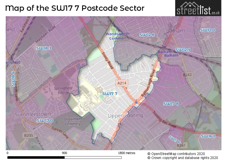
Map of the SW17 7 Postcode Sector
Explore the SW17 7 postcode sector by using our free interactive map.
| S | W | 1 | 7 | - | 7 | X | X |
| S | W | 1 | 7 | Space | 7 | Letter | Letter |
Official List of Streets
Wandsworth (64 Streets)
Unofficial Streets or Alternative Spellings
Wandsworth
BALHAM PARK ROAD BOUNDARIES ROAD BROADWATER ROAD BRUDENELL ROAD BURNTWOOD LANE COWICK ROAD DAFFORNE ROAD DERINTON ROAD DRAKEFIELD ROAD ELMFIELD ROAD FOULSER ROAD GATTON ROAD KELLINO STREET LESSINGHAM AVENUE LETCHWORTH STREET LOUISVILLE ROAD LYNWOOD ROAD NIGHTINGALE LANE OLD HOSPITAL CLOSE RITHERDON ROAD SANDGATE LANE SARSFELD ROAD SELKIRK ROAD SPRINGFIELD DRIVE STAPLETON ROAD STREATHBOURNE ROAD TOOTING BEC ROAD TOPSHAM ROAD BICKNELL WAY ELIZABETH NEWTON WAY FLOWERSMEAD FOVANT HUT HOLMBURY COURT LAPIDGE DRIVE PEAR MEWS SAINT JAMESS DRIVE SEACOLE WALK ST. ANTHONYS CLOSE ST. BENETS CLOSE THE MEWS WITHAM COURTWeather Forecast for SW17 7
Press Button to Show Forecast for Merton
| Time Period | Icon | Description | Temperature | Rain Probability | Wind |
|---|---|---|---|---|---|
| 06:00 to 09:00 | Overcast | 10.0°C (feels like 8.0°C) | 18.00% | WNW 11 mph | |
| 09:00 to 12:00 | Overcast | 11.0°C (feels like 9.0°C) | 15.00% | NW 13 mph | |
| 12:00 to 15:00 | Cloudy | 12.0°C (feels like 9.0°C) | 12.00% | NW 13 mph | |
| 15:00 to 18:00 | Cloudy | 12.0°C (feels like 10.0°C) | 14.00% | NNW 13 mph | |
| 18:00 to 21:00 | Cloudy | 11.0°C (feels like 8.0°C) | 8.00% | NNE 11 mph | |
| 21:00 to 00:00 | Cloudy | 8.0°C (feels like 6.0°C) | 8.00% | NNE 9 mph |
Press Button to Show Forecast for Merton
| Time Period | Icon | Description | Temperature | Rain Probability | Wind |
|---|---|---|---|---|---|
| 00:00 to 03:00 | Partly cloudy (night) | 7.0°C (feels like 4.0°C) | 2.00% | N 9 mph | |
| 03:00 to 06:00 | Clear night | 6.0°C (feels like 3.0°C) | 1.00% | NNW 9 mph | |
| 06:00 to 09:00 | Cloudy | 5.0°C (feels like 2.0°C) | 5.00% | NNW 9 mph | |
| 09:00 to 12:00 | Overcast | 8.0°C (feels like 5.0°C) | 8.00% | N 11 mph | |
| 12:00 to 15:00 | Overcast | 10.0°C (feels like 7.0°C) | 9.00% | N 11 mph | |
| 15:00 to 18:00 | Overcast | 11.0°C (feels like 9.0°C) | 10.00% | N 9 mph | |
| 18:00 to 21:00 | Overcast | 10.0°C (feels like 8.0°C) | 9.00% | NNE 9 mph | |
| 21:00 to 00:00 | Partly cloudy (night) | 8.0°C (feels like 6.0°C) | 2.00% | NNE 7 mph |
Press Button to Show Forecast for Merton
| Time Period | Icon | Description | Temperature | Rain Probability | Wind |
|---|---|---|---|---|---|
| 00:00 to 03:00 | Overcast | 7.0°C (feels like 5.0°C) | 8.00% | NNE 4 mph | |
| 03:00 to 06:00 | Partly cloudy (night) | 6.0°C (feels like 5.0°C) | 1.00% | N 4 mph | |
| 06:00 to 09:00 | Overcast | 6.0°C (feels like 5.0°C) | 8.00% | NNW 4 mph | |
| 09:00 to 12:00 | Overcast | 8.0°C (feels like 6.0°C) | 10.00% | N 7 mph | |
| 12:00 to 15:00 | Overcast | 10.0°C (feels like 8.0°C) | 11.00% | NNE 9 mph | |
| 15:00 to 18:00 | Overcast | 12.0°C (feels like 9.0°C) | 11.00% | NNE 11 mph | |
| 18:00 to 21:00 | Cloudy | 11.0°C (feels like 9.0°C) | 7.00% | NNE 9 mph | |
| 21:00 to 00:00 | Partly cloudy (night) | 9.0°C (feels like 6.0°C) | 3.00% | NE 9 mph |
Press Button to Show Forecast for Merton
| Time Period | Icon | Description | Temperature | Rain Probability | Wind |
|---|---|---|---|---|---|
| 00:00 to 03:00 | Clear night | 7.0°C (feels like 5.0°C) | 4.00% | NNE 7 mph | |
| 03:00 to 06:00 | Clear night | 6.0°C (feels like 4.0°C) | 3.00% | NNE 7 mph | |
| 06:00 to 09:00 | Partly cloudy (day) | 6.0°C (feels like 4.0°C) | 3.00% | NNE 7 mph | |
| 09:00 to 12:00 | Partly cloudy (day) | 9.0°C (feels like 6.0°C) | 3.00% | NNE 9 mph | |
| 12:00 to 15:00 | Cloudy | 11.0°C (feels like 9.0°C) | 8.00% | NE 9 mph | |
| 15:00 to 18:00 | Cloudy | 11.0°C (feels like 9.0°C) | 8.00% | NE 11 mph | |
| 18:00 to 21:00 | Cloudy | 11.0°C (feels like 8.0°C) | 9.00% | NE 9 mph | |
| 21:00 to 00:00 | Cloudy | 9.0°C (feels like 7.0°C) | 6.00% | NE 9 mph |
Schools and Places of Education Within the SW17 7 Postcode Sector
Al Risalah Boys' School
Other independent school
145 Upper Tooting Road, London, , SW17 7TJ
Head: Principal Suhayl Lee
Ofsted Rating: Good
Inspection: 2023-07-13 (281 days ago)
Website: Visit Al Risalah Boys' School Website
Phone: 02087676057
Number of Pupils: 110
Al Risalah Secondary School
Other independent school
145 Upper Tooting Road, London, , SW17 7TJ
Head: Mr Suhayl Lee
Ofsted Rating: Good
Inspection: 2022-03-10 (771 days ago)
Website: Visit Al Risalah Secondary School Website
Phone: 02087676057
Number of Pupils: 175
Fircroft Primary School
Community school
Fircroft Road, London, , SW17 7PP
Head: Mrs Denise York
Ofsted Rating: Requires improvement
Inspection: 2022-06-30 (659 days ago)
Website: Visit Fircroft Primary School Website
Phone: 02086726258
Number of Pupils: 339
Nightingale Community Academy
Academy special sponsor led
Beechcroft Road, London, , SW17 7DF
Head: Principal Andre Bailey
Ofsted Rating: Good
Inspection: 2022-09-15 (582 days ago)
Website: Visit Nightingale Community Academy Website
Phone: 02088749096
Number of Pupils: 120
Rutherford House School
Free schools
217 Balham High Road, London, , SW17 7BS
Head: Mrs Maxine Mallett
Ofsted Rating: Good
Inspection: 2022-07-14 (645 days ago)
Website: Visit Rutherford House School Website
Phone: 02086725901
Number of Pupils: 387
House Prices in the SW17 7 Postcode Sector
| Type of Property | 2018 Average | 2018 Sales | 2017 Average | 2017 Sales | 2016 Average | 2016 Sales | 2015 Average | 2015 Sales |
|---|---|---|---|---|---|---|---|---|
| Detached | £2,511,250 | 2 | £3,100,000 | 1 | £2,685,000 | 1 | £2,495,000 | 2 |
| Semi-Detached | £1,253,792 | 12 | £1,505,056 | 18 | £1,725,441 | 17 | £1,690,333 | 9 |
| Terraced | £957,749 | 80 | £968,572 | 60 | £991,680 | 88 | £871,654 | 67 |
| Flats | £464,864 | 95 | £492,541 | 88 | £456,941 | 121 | £484,173 | 118 |
Important Postcodes SW17 7 in the Postcode Sector
SW17 7AL is the postcode for Trinity Medical Centre, 278-280 Balham High Road
SW17 7BQ is the postcode for Wandsworth Interpreting Service, Bedford House, 215 Balham High Road, and Rutherford House School, 217 Balham High Road
SW17 7BU is the postcode for ST. PETERS CHURCH HALL, St. Peters Church, 7 Beechcroft Road
SW17 7DF is the postcode for ART AND SCIENCE, Ernest Bevin College, Beechcroft Road, Ernest Bevin College, Beechcroft Road, Nightingale School, Beechcroft Road, and ERNEST BEVIN COLLEGE, BEECHCROFT ROAD, LONDON
SW17 7DJ is the postcode for WANDSWORTH RECOVERY CENTRE, South West London and St George's Mental Health NHS Trust, Springfield University Hospital, SHAFTESBURY CLINIC, South West London and St George's Mental Health NHS Trust, Springfield University Hospital, ABCD BUILDING, South West London and St George's Mental Health NHS Trust, Springfield University Hospital, MAIN BUILDING, South West London and St George's Mental Health NHS Trust, Springfield University Hospital, JOAN BICKNELL CENTRE SPRINGFIELD HOSPITAL, Springfield Hospital, 61 Glenburnie Road, South West London and St George's Mental Health NHS Trust, Springfield University Hospital, PHOENIX UNIT, South West London and St George's Mental Health NHS Trust, Springfield University Hospital, STAFF RESTAURANT, South West London and St George's Mental Health NHS Trust, Springfield University Hospital, ADMISSIONS BUILDING, South West London and St George's Mental Health NHS Trust, Springfield University Hospital, and HAREWOOD HOUSE, South West London and St George's Mental Health NHS Trust, Springfield University Hospital
SW17 7PP is the postcode for FIRCROFT PRIMARY JUNIOR BUILDING, Fircroft Primary School, Fircroft Road, Fircroft Primary School, Fircroft Road, FIRCROFT PRIMARY SCHOOL, FIRCROFT ROAD, LONDON, Junior Building, Fircroft Primary School, Fircroft Road, and FIRCROFT PRIMARY INFANT BUILDING, Fircroft Primary School, Fircroft Road
SW17 7SQ is the postcode for Tooting Fire Station, 91 Trinity Road, Tooting, and Tooting Fire Station, 91 Trinity Road
SW17 7TG is the postcode for Grafton Medical Partners, 219 Upper Tooting Road
SW17 7TN is the postcode for 67 Upper Tooting Road
| The SW17 7 Sector is within these Local Authorities |
|
|---|---|
| The SW17 7 Sector is within these Counties |
|
| The SW17 7 Sector is within these Water Company Areas |
|