The SW19 1 postcode sector is within the county of Greater London.
Did you know? According to the 2021 Census, the SW19 1 postcode sector is home to a bustling 10,619 residents!
Given that each sector allows for 400 unique postcode combinations. Letters C, I, K, M, O and V are not allowed in the last two letters of a postcode. With 228 postcodes already in use, this leaves 172 units available.
The largest settlement in the SW19 1 postal code is WIMBLEDON followed by COLLIERS WOOD , and SOUTH WIMBLEDON .
The SW19 1 Postcode shares a border with SW17 0 (LONDON ), SW19 3 (MERTON PARK , WIMBLEDON , SOUTH WIMBLEDON ), SW19 7 (WIMBLEDON , WIMBLEDON PARK , WIMBLEDON VILLAGE ), SW19 8 (WIMBLEDON , WIMBLEDON PARK , SOUTH WIMBLEDON ) and SW19 2 (COLLIERS WOOD , SOUTH WIMBLEDON ).
The sector is within the post town of LONDON.
SW19 1 is a postcode sector within the SW19 postcode district which is within the SW South West London postcode area.
The Royal Mail delivery office for the SW19 1 postal sector is the Wimbledon Sdelivery Office.
The area of the SW19 1 postcode sector is 0.41 square miles which is 1.05 square kilometres or 259.70 square acres.
Waterways within the SW19 1 postcode sector include the River Wandle, PIckle Ditch.

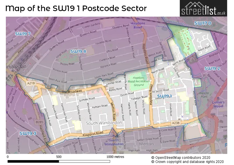
Map of the SW19 1 Postcode Sector
Explore the SW19 1 postcode sector by using our free interactive map.
| S | W | 1 | 9 | - | 1 | X | X |
| S | W | 1 | 9 | Space | 1 | Letter | Letter |
Official List of Streets
Merton (69 Streets)
Unofficial Streets or Alternative Spellings
Merton
ABBEY ROAD BRISBANE AVENUE BROADWAY PLACE BYEGROVE ROAD GARFIELD ROAD GRAHAM ROAD HARTFIELD ROAD HAYWARD CLOSE HERBERT ROAD KIRKLEY ROAD MILL ROAD MORDEN ROAD PINCOTT ROAD RUTLISH ROAD STANLEY ROAD TRINITY ROAD WIMBLEDON BRIDGE BROADWAY COURT COBDEN MEWS HACCOMBE ROAD KINGS ROAD MEAD PATH OLIVE ROAD QUEENS ROADWeather Forecast for SW19 1
Press Button to Show Forecast for Merton
| Time Period | Icon | Description | Temperature | Rain Probability | Wind |
|---|---|---|---|---|---|
| 21:00 to 00:00 | Clear night | 8.0°C (feels like 6.0°C) | 0.00% | NNE 9 mph |
Press Button to Show Forecast for Merton
| Time Period | Icon | Description | Temperature | Rain Probability | Wind |
|---|---|---|---|---|---|
| 00:00 to 03:00 | Clear night | 6.0°C (feels like 3.0°C) | 0.00% | N 9 mph | |
| 03:00 to 06:00 | Clear night | 5.0°C (feels like 2.0°C) | 0.00% | NNW 9 mph | |
| 06:00 to 09:00 | Partly cloudy (day) | 5.0°C (feels like 2.0°C) | 0.00% | NNW 9 mph | |
| 09:00 to 12:00 | Cloudy | 8.0°C (feels like 5.0°C) | 3.00% | N 11 mph | |
| 12:00 to 15:00 | Cloudy | 11.0°C (feels like 8.0°C) | 4.00% | N 11 mph | |
| 15:00 to 18:00 | Cloudy | 12.0°C (feels like 9.0°C) | 4.00% | N 11 mph | |
| 18:00 to 21:00 | Cloudy | 11.0°C (feels like 9.0°C) | 4.00% | N 9 mph | |
| 21:00 to 00:00 | Partly cloudy (night) | 8.0°C (feels like 7.0°C) | 1.00% | NNE 7 mph |
Press Button to Show Forecast for Merton
| Time Period | Icon | Description | Temperature | Rain Probability | Wind |
|---|---|---|---|---|---|
| 00:00 to 03:00 | Partly cloudy (night) | 7.0°C (feels like 5.0°C) | 2.00% | NNE 7 mph | |
| 03:00 to 06:00 | Cloudy | 6.0°C (feels like 4.0°C) | 7.00% | N 7 mph | |
| 06:00 to 09:00 | Overcast | 6.0°C (feels like 3.0°C) | 8.00% | N 7 mph | |
| 09:00 to 12:00 | Overcast | 8.0°C (feels like 5.0°C) | 9.00% | NNE 9 mph | |
| 12:00 to 15:00 | Overcast | 10.0°C (feels like 8.0°C) | 9.00% | NNE 9 mph | |
| 15:00 to 18:00 | Overcast | 12.0°C (feels like 9.0°C) | 9.00% | NNE 11 mph | |
| 18:00 to 21:00 | Partly cloudy (day) | 11.0°C (feels like 8.0°C) | 4.00% | NNE 11 mph | |
| 21:00 to 00:00 | Clear night | 8.0°C (feels like 6.0°C) | 4.00% | NNE 9 mph |
Press Button to Show Forecast for Merton
| Time Period | Icon | Description | Temperature | Rain Probability | Wind |
|---|---|---|---|---|---|
| 00:00 to 03:00 | Clear night | 6.0°C (feels like 4.0°C) | 3.00% | NNE 7 mph | |
| 03:00 to 06:00 | Partly cloudy (night) | 5.0°C (feels like 3.0°C) | 3.00% | N 4 mph | |
| 06:00 to 09:00 | Partly cloudy (day) | 5.0°C (feels like 3.0°C) | 2.00% | N 4 mph | |
| 09:00 to 12:00 | Cloudy | 8.0°C (feels like 6.0°C) | 7.00% | NNE 7 mph | |
| 12:00 to 15:00 | Cloudy | 10.0°C (feels like 8.0°C) | 9.00% | N 7 mph | |
| 15:00 to 18:00 | Overcast | 10.0°C (feels like 9.0°C) | 16.00% | NNW 7 mph | |
| 18:00 to 21:00 | Overcast | 10.0°C (feels like 8.0°C) | 18.00% | NNW 7 mph | |
| 21:00 to 00:00 | Light rain | 8.0°C (feels like 7.0°C) | 46.00% | N 4 mph |
Press Button to Show Forecast for Merton
| Time Period | Icon | Description | Temperature | Rain Probability | Wind |
|---|---|---|---|---|---|
| 00:00 to 03:00 | Overcast | 7.0°C (feels like 6.0°C) | 17.00% | NE 4 mph | |
| 03:00 to 06:00 | Cloudy | 6.0°C (feels like 5.0°C) | 13.00% | NNE 4 mph | |
| 06:00 to 09:00 | Cloudy | 6.0°C (feels like 5.0°C) | 12.00% | N 4 mph | |
| 09:00 to 12:00 | Cloudy | 8.0°C (feels like 7.0°C) | 11.00% | NNE 7 mph | |
| 12:00 to 15:00 | Overcast | 11.0°C (feels like 9.0°C) | 16.00% | NNE 9 mph | |
| 15:00 to 18:00 | Overcast | 12.0°C (feels like 10.0°C) | 11.00% | NNE 9 mph | |
| 18:00 to 21:00 | Cloudy | 11.0°C (feels like 10.0°C) | 8.00% | NNE 9 mph | |
| 21:00 to 00:00 | Clear night | 9.0°C (feels like 7.0°C) | 8.00% | NNE 7 mph |
Schools and Places of Education Within the SW19 1 Postcode Sector
All Saints' CofE Primary School
Voluntary aided school
3 - 19 Hanover Road, London, , SW19 1EB
Head: Mrs Angela Filsell
Ofsted Rating: Good
Inspection: 2019-09-26 (1667 days ago)
Website: Visit All Saints' CofE Primary School Website
Phone: 02085403004
Number of Pupils: 339
Pelham Primary School
Community school
Southey Road, London, , SW19 1NU
Head: Mrs Emma Greer
Ofsted Rating: Good
Inspection: 2022-03-30 (751 days ago)
Website: Visit Pelham Primary School Website
Phone: 02085422005
Number of Pupils: 417
St Mary's Catholic Primary School
Voluntary aided school
Russell Road, London, , SW19 1QL
Head: Mr David McCabe
Ofsted Rating: Good
Inspection: 2021-12-08 (863 days ago)
Website: Visit St Mary's Catholic Primary School Website
Phone: 02085424580
Number of Pupils: 443
House Prices in the SW19 1 Postcode Sector
| Type of Property | 2018 Average | 2018 Sales | 2017 Average | 2017 Sales | 2016 Average | 2016 Sales | 2015 Average | 2015 Sales |
|---|---|---|---|---|---|---|---|---|
| Detached | £0 | 0 | £705,500 | 3 | £0 | 0 | £1,070,000 | 1 |
| Semi-Detached | £1,113,750 | 12 | £826,625 | 12 | £980,814 | 11 | £848,717 | 9 |
| Terraced | £690,253 | 71 | £722,291 | 58 | £813,872 | 89 | £681,338 | 94 |
| Flats | £448,832 | 102 | £412,248 | 87 | £425,099 | 119 | £414,838 | 122 |
Important Postcodes SW19 1 in the Postcode Sector
SW19 1AR is the postcode for All Saints C of E First School, East Road
SW19 1BX is the postcode for All Saints Centre, 44 All Saints Road
SW19 1EW is the postcode for Wimbledon Leisure Centre, Latimer Road
SW19 1HL is the postcode for All Saints School, 72-74 Haydons Road
SW19 1JN is the postcode for Wimbledon Fire Station, 87 Kingston Road
SW19 1NU is the postcode for Pelham Primary School, Southey Road, and Pelham Primary School, Southey Road, Wimbledon
SW19 1NX is the postcode for The Patrick Doody Clinic & Health Centre, Pelham Road
SW19 1PB is the postcode for Wimbledon College of Art, Palmerston Road
SW19 1QL is the postcode for St. Marys RC Primary School, Russell Road
SW19 1RH is the postcode for NHS London, 120 The Broadway, and 120 The Broadway
SW19 1RY is the postcode for YMCA, 200 The Broadway
| The SW19 1 Sector is within these Local Authorities |
|
|---|---|
| The SW19 1 Sector is within these Counties |
|
| The SW19 1 Sector is within these Water Company Areas |
|