The SY5 9 postcode sector stands on the Powys and Shropshire border.
Did you know? According to the 2021 Census, the SY5 9 postcode sector is home to a bustling 5,036 residents!
Given that each sector allows for 400 unique postcode combinations. Letters C, I, K, M, O and V are not allowed in the last two letters of a postcode. With 236 postcodes already in use, this leaves 164 units available.
The largest settlement in the SY5 9 postal code is Westbury followed by Ford, and Halfway House.
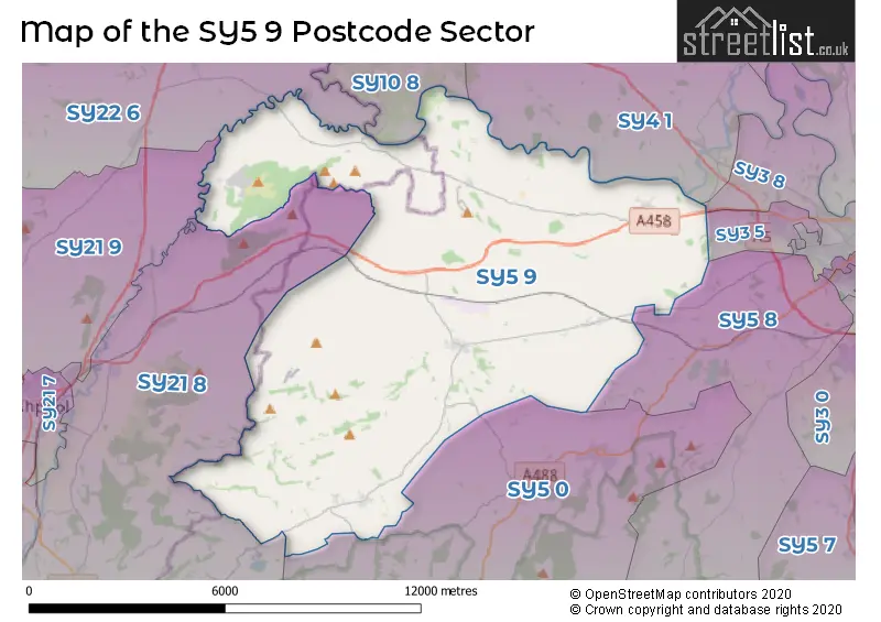
The SY5 9 Postcode shares a border with SY4 1 (Montford Bridge, Ruyton XI Towns, Nesscliffe), SY5 0 (Minsterley, Pontesbury, Snailbeach), SY22 6 (LLANSANTFFRAID-YM-MECHAIN, LLANYMYNECH, MEIFOD), SY3 5 (Bicton Heath, SHREWSBURY, Bowbrook), SY5 8 (Hanwood, Bowbrook, Longden), SY3 8 (SHREWSBURY, Bicton, Bicton Heath), SY10 8 (Kinnerley, OSWESTRY, Pant), SY21 8 (FORDEN, BERRIEW, MIDDLETOWN) and SY21 9 (GUILSFIELD, CASTLE CAEREINION, POOL QUAY).
The sector is within the post town of SHREWSBURY.
SY5 9 is a postcode sector within the SY5 postcode district which is within the SY Shrewsbury postcode area.
The Royal Mail delivery office for the SY5 9 postal sector is the Shrewsbury Delivery Office and Westbury Scale Payment Delivery Office.
The area of the SY5 9 postcode sector is 48.58 square miles which is 125.82 square kilometres or 31,090.97 square acres.

Map of the SY5 9 Postcode Sector
Explore the SY5 9 postcode sector by using our free interactive map.
| S | Y | 5 | - | 9 | X | X |
| S | Y | 5 | Space | 9 | Letter | Letter |
Official List of Streets
Ford (15 Streets)
Westbury (18 Streets)
Crew Green (9 Streets)
Worthen (14 Streets)
Yockleton (2 Streets)
Halfway House (11 Streets)
Ford Heath (1 Streets)
Coedway (1 Streets)
Alberbury (1 Streets)
Unofficial Streets or Alternative Spellings
Bicton Heath
WELSHPOOL ROADTrewern
CRIGGION LANEWeather Forecast for SY5 9
Press Button to Show Forecast for Westbury (Shropshire)
| Time Period | Icon | Description | Temperature | Rain Probability | Wind |
|---|---|---|---|---|---|
| 00:00 to 03:00 | Overcast | 9.0°C (feels like 6.0°C) | 13.00% | WNW 13 mph | |
| 03:00 to 06:00 | Cloudy | 9.0°C (feels like 6.0°C) | 14.00% | WNW 13 mph | |
| 06:00 to 09:00 | Cloudy | 8.0°C (feels like 6.0°C) | 10.00% | WNW 11 mph | |
| 09:00 to 12:00 | Cloudy | 10.0°C (feels like 7.0°C) | 11.00% | NW 16 mph | |
| 12:00 to 15:00 | Cloudy | 11.0°C (feels like 7.0°C) | 9.00% | NNW 20 mph | |
| 15:00 to 18:00 | Partly cloudy (day) | 11.0°C (feels like 8.0°C) | 2.00% | NNW 18 mph | |
| 18:00 to 21:00 | Sunny day | 9.0°C (feels like 6.0°C) | 2.00% | NNW 11 mph | |
| 21:00 to 00:00 | Clear night | 6.0°C (feels like 4.0°C) | 2.00% | NNW 7 mph |
Press Button to Show Forecast for Westbury (Shropshire)
| Time Period | Icon | Description | Temperature | Rain Probability | Wind |
|---|---|---|---|---|---|
| 00:00 to 03:00 | Partly cloudy (night) | 4.0°C (feels like 3.0°C) | 0.00% | N 4 mph | |
| 03:00 to 06:00 | Partly cloudy (night) | 3.0°C (feels like 2.0°C) | 2.00% | NW 2 mph | |
| 06:00 to 09:00 | Sunny day | 4.0°C (feels like 3.0°C) | 2.00% | NW 2 mph | |
| 09:00 to 12:00 | Partly cloudy (day) | 8.0°C (feels like 7.0°C) | 2.00% | NNE 4 mph | |
| 12:00 to 15:00 | Cloudy | 10.0°C (feels like 9.0°C) | 6.00% | NNE 7 mph | |
| 15:00 to 18:00 | Cloudy | 11.0°C (feels like 10.0°C) | 5.00% | NNE 7 mph | |
| 18:00 to 21:00 | Sunny day | 10.0°C (feels like 9.0°C) | 2.00% | NNE 7 mph | |
| 21:00 to 00:00 | Clear night | 5.0°C (feels like 4.0°C) | 1.00% | N 2 mph |
Press Button to Show Forecast for Westbury (Shropshire)
| Time Period | Icon | Description | Temperature | Rain Probability | Wind |
|---|---|---|---|---|---|
| 00:00 to 03:00 | Clear night | 4.0°C (feels like 2.0°C) | 1.00% | NW 2 mph | |
| 03:00 to 06:00 | Clear night | 3.0°C (feels like 2.0°C) | 1.00% | NW 2 mph | |
| 06:00 to 09:00 | Partly cloudy (day) | 5.0°C (feels like 3.0°C) | 1.00% | WNW 2 mph | |
| 09:00 to 12:00 | Partly cloudy (day) | 10.0°C (feels like 9.0°C) | 1.00% | N 4 mph | |
| 12:00 to 15:00 | Cloudy | 12.0°C (feels like 10.0°C) | 5.00% | NNE 9 mph | |
| 15:00 to 18:00 | Overcast | 12.0°C (feels like 10.0°C) | 11.00% | NNE 9 mph | |
| 18:00 to 21:00 | Cloudy | 11.0°C (feels like 9.0°C) | 6.00% | NE 7 mph | |
| 21:00 to 00:00 | Cloudy | 8.0°C (feels like 6.0°C) | 5.00% | NE 4 mph |
Press Button to Show Forecast for Westbury (Shropshire)
| Time Period | Icon | Description | Temperature | Rain Probability | Wind |
|---|---|---|---|---|---|
| 00:00 to 03:00 | Cloudy | 6.0°C (feels like 5.0°C) | 6.00% | NE 4 mph | |
| 03:00 to 06:00 | Cloudy | 5.0°C (feels like 3.0°C) | 8.00% | NE 4 mph | |
| 06:00 to 09:00 | Cloudy | 5.0°C (feels like 4.0°C) | 8.00% | NE 4 mph | |
| 09:00 to 12:00 | Cloudy | 8.0°C (feels like 7.0°C) | 6.00% | NE 7 mph | |
| 12:00 to 15:00 | Cloudy | 10.0°C (feels like 8.0°C) | 11.00% | ENE 7 mph | |
| 15:00 to 18:00 | Cloudy | 11.0°C (feels like 9.0°C) | 10.00% | NE 9 mph | |
| 18:00 to 21:00 | Cloudy | 10.0°C (feels like 8.0°C) | 9.00% | ENE 7 mph | |
| 21:00 to 00:00 | Partly cloudy (night) | 7.0°C (feels like 5.0°C) | 4.00% | NE 4 mph |
Schools and Places of Education Within the SY5 9 Postcode Sector
Long Mountain CofE Primary School
Voluntary controlled school
Worthen, Shrewsbury, Shropshire, SY5 9HT
Head: Mr Jon-Anders Rowlands
Ofsted Rating: Requires improvement
Inspection: 2022-01-19 (821 days ago)
Website: Visit Long Mountain CofE Primary School Website
Phone: 01743891320
Number of Pupils: 128
Trinity CofE Primary School
Voluntary controlled school
Butt Lane, Shrewsbury, Shropshire, SY5 9LG
Head: Mr Jack Pittaway
Ofsted Rating: Good
Inspection: 2022-11-09 (527 days ago)
Website: Visit Trinity CofE Primary School Website
Phone: 01743850227
Number of Pupils: 154
Westbury School
Other independent special school
School Lane, Shropshire, , SY5 9QZ
Head: Mrs Nadia Chelpa
Ofsted Rating: Good
Inspection: 2022-06-22 (667 days ago)
Website: Visit Westbury School Website
Phone: 01743884195
Number of Pupils: 6
House Prices in the SY5 9 Postcode Sector
| Type of Property | 2018 Average | 2018 Sales | 2017 Average | 2017 Sales | 2016 Average | 2016 Sales | 2015 Average | 2015 Sales |
|---|---|---|---|---|---|---|---|---|
| Detached | £318,056 | 34 | £285,305 | 36 | £299,233 | 32 | £277,134 | 28 |
| Semi-Detached | £166,559 | 17 | £184,143 | 14 | £196,650 | 15 | £137,800 | 15 |
| Terraced | £150,250 | 8 | £159,889 | 9 | £132,100 | 5 | £212,750 | 2 |
| Flats | £166,575 | 4 | £148,500 | 4 | £207,250 | 2 | £94,500 | 2 |
Important Postcodes SY5 9 in the Postcode Sector
SY5 9LG is the postcode for Trinity C of E Primary School, Ford
SY5 9QX is the postcode for St. Marys C of E Primary School, 1
| The SY5 9 Sector is within these Local Authorities |
|
|---|---|
| The SY5 9 Sector is within these Counties |
|
| The SY5 9 Sector is within these Water Company Areas |
|