The TA10 9 postcode sector is within the county of Somerset.
Did you know? According to the 2021 Census, the TA10 9 postcode sector is home to a bustling 5,972 residents!
Given that each sector allows for 400 unique postcode combinations. Letters C, I, K, M, O and V are not allowed in the last two letters of a postcode. With 251 postcodes already in use, this leaves 149 units available.
The largest settlement in the TA10 9 postal code is LANGPORT followed by Long Sutton, and Pitney.
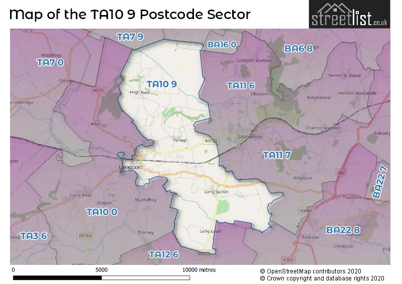
The TA10 9 Postcode shares a border with TA7 9 (Ashcott, Chilton Polden, Catcott), TA10 0 (Curry Rivel, Hambridge, Drayton), TA11 6 (SOMERTON, Keinton Mandeville, Compton Dundon), TA11 7 (SOMERTON, Charlton Adam, Kingsdon), TA12 6 (MARTOCK, Kingsbury Episcopi, Bower Hinton), BA16 0 (STREET), BA16 9 (STREET, Walton, Sharpham) and BA22 8 (Ilchester, Houndstone, Tintinhull).
The sector is within the post town of LANGPORT.
TA10 9 is a postcode sector within the TA10 postcode district which is within the TA Taunton postcode area.
The Royal Mail delivery office for the TA10 9 postal sector is the Langport Delivery Office.
The area of the TA10 9 postcode sector is 20.23 square miles which is 52.40 square kilometres or 12,947.72 square acres.
Waterways within the TA10 9 postcode sector include the River Parratt, River Yeo, River Cary.

Map of the TA10 9 Postcode Sector
Explore the TA10 9 postcode sector by using our free interactive map.
| T | A | 1 | 0 | - | 9 | X | X |
| T | A | 1 | 0 | Space | 9 | Letter | Letter |
Official List of Streets
Long Sutton (17 Streets)
LANGPORT (66 Streets)
Knole (1 Streets)
Pitney (7 Streets)
Long Load (5 Streets)
Huish Episcopi (6 Streets)
High Ham (6 Streets)
Henley (1 Streets)
Pibsbury (1 Streets)
Unofficial Streets or Alternative Spellings
LANGPORT
EASTOVER CLOSE FROG LANESOMERTON
SOMERTONFIELD ROADAshcott
NYTHE ROADWeather Forecast for TA10 9
Press Button to Show Forecast for Langport
| Time Period | Icon | Description | Temperature | Rain Probability | Wind |
|---|---|---|---|---|---|
| 12:00 to 15:00 | Cloudy | 12.0°C (feels like 10.0°C) | 5.00% | NNW 9 mph | |
| 15:00 to 18:00 | Partly cloudy (day) | 13.0°C (feels like 11.0°C) | 1.00% | NNW 9 mph | |
| 18:00 to 21:00 | Cloudy | 12.0°C (feels like 10.0°C) | 3.00% | NW 7 mph | |
| 21:00 to 00:00 | Partly cloudy (night) | 8.0°C (feels like 7.0°C) | 1.00% | NNW 7 mph |
Press Button to Show Forecast for Langport
| Time Period | Icon | Description | Temperature | Rain Probability | Wind |
|---|---|---|---|---|---|
| 00:00 to 03:00 | Clear night | 6.0°C (feels like 4.0°C) | 0.00% | W 7 mph | |
| 03:00 to 06:00 | Clear night | 5.0°C (feels like 3.0°C) | 1.00% | W 7 mph | |
| 06:00 to 09:00 | Sunny day | 6.0°C (feels like 4.0°C) | 1.00% | WNW 7 mph | |
| 09:00 to 12:00 | Partly cloudy (day) | 10.0°C (feels like 8.0°C) | 1.00% | WNW 9 mph | |
| 12:00 to 15:00 | Cloudy | 12.0°C (feels like 9.0°C) | 5.00% | WNW 11 mph | |
| 15:00 to 18:00 | Cloudy | 12.0°C (feels like 9.0°C) | 4.00% | WNW 13 mph | |
| 18:00 to 21:00 | Partly cloudy (day) | 11.0°C (feels like 8.0°C) | 2.00% | WNW 11 mph | |
| 21:00 to 00:00 | Partly cloudy (night) | 8.0°C (feels like 6.0°C) | 2.00% | WNW 9 mph |
Press Button to Show Forecast for Langport
| Time Period | Icon | Description | Temperature | Rain Probability | Wind |
|---|---|---|---|---|---|
| 00:00 to 03:00 | Cloudy | 7.0°C (feels like 6.0°C) | 5.00% | NW 7 mph | |
| 03:00 to 06:00 | Cloudy | 7.0°C (feels like 5.0°C) | 11.00% | S 4 mph | |
| 06:00 to 09:00 | Cloudy | 7.0°C (feels like 6.0°C) | 12.00% | SE 7 mph | |
| 09:00 to 12:00 | Cloudy | 10.0°C (feels like 8.0°C) | 11.00% | SE 9 mph | |
| 12:00 to 15:00 | Cloudy | 11.0°C (feels like 9.0°C) | 17.00% | S 9 mph | |
| 15:00 to 18:00 | Cloudy | 11.0°C (feels like 9.0°C) | 17.00% | S 9 mph | |
| 18:00 to 21:00 | Cloudy | 10.0°C (feels like 8.0°C) | 18.00% | SSE 9 mph | |
| 21:00 to 00:00 | Cloudy | 8.0°C (feels like 6.0°C) | 17.00% | ENE 7 mph |
Press Button to Show Forecast for Langport
| Time Period | Icon | Description | Temperature | Rain Probability | Wind |
|---|---|---|---|---|---|
| 00:00 to 03:00 | Cloudy | 8.0°C (feels like 6.0°C) | 19.00% | E 7 mph | |
| 03:00 to 06:00 | Cloudy | 7.0°C (feels like 5.0°C) | 15.00% | ENE 7 mph | |
| 06:00 to 09:00 | Cloudy | 8.0°C (feels like 6.0°C) | 16.00% | ENE 9 mph | |
| 09:00 to 12:00 | Cloudy | 10.0°C (feels like 8.0°C) | 15.00% | ENE 11 mph | |
| 12:00 to 15:00 | Overcast | 12.0°C (feels like 10.0°C) | 20.00% | E 11 mph | |
| 15:00 to 18:00 | Cloudy | 12.0°C (feels like 10.0°C) | 19.00% | ENE 11 mph | |
| 18:00 to 21:00 | Light rain shower (day) | 11.0°C (feels like 9.0°C) | 38.00% | E 9 mph | |
| 21:00 to 00:00 | Light rain | 10.0°C (feels like 8.0°C) | 50.00% | E 9 mph |
Schools and Places of Education Within the TA10 9 Postcode Sector
High Ham Church of England Primary School
Voluntary controlled school
High Ham, Langport, Somerset, TA10 9BY
Head: Mrs Ann Edwards
Ofsted Rating: Good
Inspection: 2022-09-22 (580 days ago)
Website: Visit High Ham Church of England Primary School Website
Phone: 01458250735
Number of Pupils: 152
Huish Episcopi Primary School
Academy converter
North Street, Langport, Somerset, TA10 9RW
Head: Mrs Tiffany Doughty Davis
Ofsted Rating: Good
Inspection: 2020-02-27 (1518 days ago)
Website: Visit Huish Episcopi Primary School Website
Phone: 01458250673
Number of Pupils: 193
Long Sutton CofE Primary School
Voluntary aided school
Martock Road, Langport, Somerset, TA10 9NT
Head: Mrs Elizabeth Reynolds
Ofsted Rating: Good
Inspection: 2018-02-27 (2248 days ago)
Website: Visit Long Sutton CofE Primary School Website
Phone: 01458241434
Number of Pupils: 107
House Prices in the TA10 9 Postcode Sector
| Type of Property | 2018 Average | 2018 Sales | 2017 Average | 2017 Sales | 2016 Average | 2016 Sales | 2015 Average | 2015 Sales |
|---|---|---|---|---|---|---|---|---|
| Detached | £369,436 | 43 | £410,289 | 59 | £343,629 | 35 | £368,137 | 53 |
| Semi-Detached | £249,240 | 25 | £234,342 | 25 | £222,553 | 19 | £206,464 | 43 |
| Terraced | £249,317 | 18 | £227,661 | 18 | £176,013 | 27 | £173,661 | 23 |
| Flats | £120,038 | 13 | £119,167 | 6 | £106,167 | 6 | £101,790 | 5 |
Important Postcodes TA10 9 in the Postcode Sector
TA10 9BY is the postcode for High Ham Church Of England Primary School, Burrow Lane, High Ham
TA10 9NT is the postcode for Long Sutton C of E VA Primary School, Martock Road
TA10 9RH is the postcode for Langport Surgery, North Street
TA10 9RW is the postcode for Huish Episcopi Primary School - Hall, North St, and Huish Episcopi Primary School, North St
TA10 9RY is the postcode for Wyvern Nursery & the Levels, Eastover
TA10 9SS is the postcode for SPORTS CENTRE, Huish Episcopi Secondary School Science College, Wincanton Road, MAIN BUILDING, Huish Episcopi Secondary School Science College, Wincanton Road, LOWER SCHOOL, Huish Episcopi Secondary School Science College, Wincanton Road, SIXTH FORM, Huish Episcopi Secondary School Science College, Wincanton Road, and SCIENCE BLOCK, Huish Episcopi Secondary School Science College, Wincanton Road
| The TA10 9 Sector is within these Local Authorities |
|
|---|---|
| The TA10 9 Sector is within these Counties |
|
| The TA10 9 Sector is within these Water Company Areas |
|
Tourist Attractions within the TA10 9 Postcode Area
We found 1 visitor attractions within the TA10 postcode area
| Stembridge Tower Mill |
|---|
| Historic Properties |
| Other Historic Property |
| View Stembridge Tower Mill on Google Maps |