The TA8 2 postcode sector lies where the three counties of Bristol, South Glamorgan, and Somerset meet.
Did you know? According to the 2021 Census, the TA8 2 postcode sector is home to a bustling 9,188 residents!
Given that each sector allows for 400 unique postcode combinations. Letters C, I, K, M, O and V are not allowed in the last two letters of a postcode. With 246 postcodes already in use, this leaves 154 units available.
The largest settlement in the TA8 2 postal code is BURNHAM-ON-SEA followed by Berrow, and Brean.
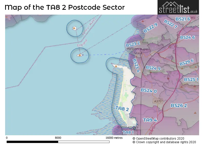
The TA8 2 Postcode shares a border with TA9 4 (HIGHBRIDGE, Mark, Brent Knoll), BS24 0 (Bleadon, Lympsham, Edingworth) and TA8 1 (BURNHAM-ON-SEA).
The sector is within the post town of BURNHAM-ON-SEA.
TA8 2 is a postcode sector within the TA8 postcode district which is within the TA Taunton postcode area.
The Royal Mail delivery office for the TA8 2 postal sector is the Burnham On Sea Delivery Office.
The area of the TA8 2 postcode sector is 6.82 square miles which is 17.67 square kilometres or 4,366.76 square acres.
Waterways within the TA8 2 postcode sector include the Pitland Rhynd.

Map of the TA8 2 Postcode Sector
Explore the TA8 2 postcode sector by using our free interactive map.
| T | A | 8 | - | 2 | X | X |
| T | A | 8 | Space | 2 | Letter | Letter |
Official List of Streets
BURNHAM-ON-SEA (127 Streets)
Berrow (28 Streets)
Unofficial Streets or Alternative Spellings
BURNHAM-ON-SEA
EXETER CLOSE LOVE LANE OXFORD STREET TRURO CLOSE BERROW WALL BRAMBLE DRIVE BREAN COURT BREAN DOWN ROAD CAMPOLINE DRIVE GARDEN HURST CLOSE GRASS ROAD GREEN LANE GRENVILE ROAD HILL VIEW KNOLL PARK NEWTON CLOSE NORTH LANE OLD COTE DRIVE SAINT CHRISTOPHERS WAY SHRUBBERY CLOSE ST BRIDGETS CLOSE ST LUKES CLOSE ST PETERS ROAD THE DRIVE WEST FIELD LAWN WICK ROAD ZIG ZAG PATHBrent Knoll
BRENT ROAD CROOKED LANE MIDDLE STREETWeather Forecast for TA8 2
Press Button to Show Forecast for Berrow - North Of Unity Farm (Beach)
| Time Period | Icon | Description | Temperature | Rain Probability | Wind |
|---|---|---|---|---|---|
| 06:00 to 09:00 | Cloudy | 8.0°C (feels like 7.0°C) | 6.00% | N 4 mph | |
| 09:00 to 12:00 | Partly cloudy (day) | 10.0°C (feels like 8.0°C) | 2.00% | N 9 mph | |
| 12:00 to 15:00 | Cloudy | 12.0°C (feels like 10.0°C) | 6.00% | NNW 9 mph | |
| 15:00 to 18:00 | Cloudy | 12.0°C (feels like 10.0°C) | 4.00% | NW 11 mph | |
| 18:00 to 21:00 | Partly cloudy (day) | 12.0°C (feels like 11.0°C) | 2.00% | NNW 7 mph | |
| 21:00 to 00:00 | Clear night | 9.0°C (feels like 7.0°C) | 1.00% | N 7 mph |
Press Button to Show Forecast for Berrow - North Of Unity Farm (Beach)
| Time Period | Icon | Description | Temperature | Rain Probability | Wind |
|---|---|---|---|---|---|
| 00:00 to 03:00 | Partly cloudy (night) | 7.0°C (feels like 6.0°C) | 1.00% | NE 7 mph | |
| 03:00 to 06:00 | Partly cloudy (night) | 6.0°C (feels like 5.0°C) | 2.00% | NNE 4 mph | |
| 06:00 to 09:00 | Cloudy | 8.0°C (feels like 6.0°C) | 5.00% | N 7 mph | |
| 09:00 to 12:00 | Overcast | 10.0°C (feels like 8.0°C) | 7.00% | NW 7 mph | |
| 12:00 to 15:00 | Overcast | 11.0°C (feels like 9.0°C) | 10.00% | NW 11 mph | |
| 15:00 to 18:00 | Cloudy | 11.0°C (feels like 9.0°C) | 7.00% | NNW 11 mph | |
| 18:00 to 21:00 | Cloudy | 11.0°C (feels like 9.0°C) | 5.00% | N 9 mph | |
| 21:00 to 00:00 | Partly cloudy (night) | 8.0°C (feels like 6.0°C) | 3.00% | NNE 9 mph |
Press Button to Show Forecast for Berrow - North Of Unity Farm (Beach)
| Time Period | Icon | Description | Temperature | Rain Probability | Wind |
|---|---|---|---|---|---|
| 00:00 to 03:00 | Partly cloudy (night) | 6.0°C (feels like 4.0°C) | 2.00% | NE 7 mph | |
| 03:00 to 06:00 | Partly cloudy (night) | 6.0°C (feels like 3.0°C) | 2.00% | NNE 7 mph | |
| 06:00 to 09:00 | Partly cloudy (day) | 6.0°C (feels like 4.0°C) | 1.00% | NNE 7 mph | |
| 09:00 to 12:00 | Cloudy | 8.0°C (feels like 6.0°C) | 5.00% | N 9 mph | |
| 12:00 to 15:00 | Overcast | 10.0°C (feels like 8.0°C) | 9.00% | NW 9 mph | |
| 15:00 to 18:00 | Cloudy | 11.0°C (feels like 9.0°C) | 7.00% | NW 9 mph | |
| 18:00 to 21:00 | Cloudy | 10.0°C (feels like 8.0°C) | 7.00% | NW 9 mph | |
| 21:00 to 00:00 | Cloudy | 9.0°C (feels like 7.0°C) | 4.00% | WNW 7 mph |
Press Button to Show Forecast for Berrow - North Of Unity Farm (Beach)
| Time Period | Icon | Description | Temperature | Rain Probability | Wind |
|---|---|---|---|---|---|
| 00:00 to 03:00 | Partly cloudy (night) | 8.0°C (feels like 6.0°C) | 4.00% | SSE 7 mph | |
| 03:00 to 06:00 | Cloudy | 7.0°C (feels like 5.0°C) | 12.00% | S 7 mph | |
| 06:00 to 09:00 | Cloudy | 7.0°C (feels like 5.0°C) | 11.00% | NNE 7 mph | |
| 09:00 to 12:00 | Cloudy | 9.0°C (feels like 8.0°C) | 10.00% | ESE 7 mph | |
| 12:00 to 15:00 | Cloudy | 11.0°C (feels like 9.0°C) | 12.00% | SSW 7 mph | |
| 15:00 to 18:00 | Cloudy | 11.0°C (feels like 9.0°C) | 14.00% | SSW 9 mph | |
| 18:00 to 21:00 | Cloudy | 11.0°C (feels like 9.0°C) | 12.00% | S 9 mph | |
| 21:00 to 00:00 | Cloudy | 9.0°C (feels like 7.0°C) | 10.00% | S 7 mph |
House Prices in the TA8 2 Postcode Sector
| Type of Property | 2018 Average | 2018 Sales | 2017 Average | 2017 Sales | 2016 Average | 2016 Sales | 2015 Average | 2015 Sales |
|---|---|---|---|---|---|---|---|---|
| Detached | £332,019 | 94 | £323,525 | 86 | £301,524 | 100 | £261,583 | 105 |
| Semi-Detached | £242,622 | 64 | £224,553 | 78 | £203,012 | 69 | £199,934 | 70 |
| Terraced | £177,818 | 25 | £194,491 | 17 | £156,144 | 25 | £157,358 | 18 |
| Flats | £123,154 | 37 | £114,945 | 42 | £121,686 | 39 | £99,117 | 29 |
Important Postcodes TA8 2 in the Postcode Sector
TA8 2ET is the postcode for Burnham on Sea Swim and Sports Academy, Berrow Road
TA8 2JU is the postcode for BURNHAM MEDICAL CENTRE, Berrow Health Campus, Brent Road, and Mulberry Centre, Brent Road
TA8 2LJ is the postcode for Berrow Primary School, Rugosa Drive, Berrow Church Of England Primary School, Rugosa Drive, Berrow, and BERROW V C PRIMARY SCHOOL, RUGOSA DRIVE, BERROW
TA8 2NF is the postcode for Little Court Community Unit for the Elderly, 2 Pinnocks Croft
| The TA8 2 Sector is within these Local Authorities |
|
|---|---|
| The TA8 2 Sector is within these Counties |
|
| The TA8 2 Sector is within these Water Company Areas |
|