The TF3 5 postcode sector is within the county of Shropshire.
Did you know? According to the 2021 Census, the TF3 5 postcode sector is home to a bustling 6,796 residents!
Given that each sector allows for 400 unique postcode combinations. Letters C, I, K, M, O and V are not allowed in the last two letters of a postcode. With 136 postcodes already in use, this leaves 264 units available.
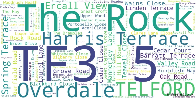
The largest settlement in the TF3 5 postal code is TELFORD followed by The Rock, and Overdale.
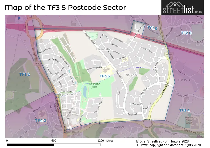
The TF3 5 Postcode shares a border with TF1 5 (Hadley, Ketley, TELFORD), TF1 2 (Wellington, Arleston), TF2 0 (Ketley Bank, TELFORD), TF3 4 (Town Centre, Old Park, TELFORD) and TF4 2 (Dawley, Lawley Village, Dawley Bank).
The sector is within the post town of TELFORD.
TF3 5 is a postcode sector within the TF3 postcode district which is within the TF Telford postcode area.
The Royal Mail delivery office for the TF3 5 postal sector is the Tweedale Delivery Office.
The area of the TF3 5 postcode sector is 0.71 square miles which is 1.83 square kilometres or 452.89 square acres.
The TF3 5 postcode sector is crossed by the M54 motorway.

Map of the TF3 5 Postcode Sector
Explore the TF3 5 postcode sector by using our free interactive map.
| T | F | 3 | - | 5 | X | X |
| T | F | 3 | Space | 5 | Letter | Letter |
Official List of Streets
The Rock (34 Streets)
TELFORD (70 Streets)
Unofficial Streets or Alternative Spellings
Weather Forecast for TF3 5
Press Button to Show Forecast for Telford
| Time Period | Icon | Description | Temperature | Rain Probability | Wind |
|---|---|---|---|---|---|
| 00:00 to 03:00 | Cloudy | 4.0°C (feels like 2.0°C) | 7.00% | E 7 mph | |
| 03:00 to 06:00 | Cloudy | 3.0°C (feels like 1.0°C) | 8.00% | E 4 mph | |
| 06:00 to 09:00 | Cloudy | 3.0°C (feels like 1.0°C) | 6.00% | ENE 4 mph | |
| 09:00 to 12:00 | Cloudy | 6.0°C (feels like 4.0°C) | 47.00% | ENE 4 mph | |
| 12:00 to 15:00 | Cloudy | 8.0°C (feels like 7.0°C) | 8.00% | E 4 mph | |
| 15:00 to 18:00 | Cloudy | 9.0°C (feels like 8.0°C) | 11.00% | ENE 4 mph | |
| 18:00 to 21:00 | Cloudy | 9.0°C (feels like 7.0°C) | 9.00% | ENE 4 mph | |
| 21:00 to 00:00 | Partly cloudy (night) | 5.0°C (feels like 3.0°C) | 7.00% | E 7 mph |
Press Button to Show Forecast for Telford
| Time Period | Icon | Description | Temperature | Rain Probability | Wind |
|---|---|---|---|---|---|
| 00:00 to 03:00 | Partly cloudy (night) | 3.0°C (feels like 0.0°C) | 7.00% | ENE 7 mph | |
| 03:00 to 06:00 | Cloudy | 2.0°C (feels like 0.0°C) | 11.00% | ENE 4 mph | |
| 06:00 to 09:00 | Cloudy | 3.0°C (feels like 1.0°C) | 11.00% | ENE 4 mph | |
| 09:00 to 12:00 | Cloudy | 7.0°C (feels like 5.0°C) | 14.00% | E 9 mph | |
| 12:00 to 15:00 | Overcast | 9.0°C (feels like 7.0°C) | 21.00% | E 9 mph | |
| 15:00 to 18:00 | Overcast | 10.0°C (feels like 8.0°C) | 22.00% | ENE 9 mph | |
| 18:00 to 21:00 | Cloudy | 9.0°C (feels like 7.0°C) | 17.00% | ENE 9 mph | |
| 21:00 to 00:00 | Cloudy | 7.0°C (feels like 4.0°C) | 20.00% | NE 9 mph |
Press Button to Show Forecast for Telford
| Time Period | Icon | Description | Temperature | Rain Probability | Wind |
|---|---|---|---|---|---|
| 00:00 to 03:00 | Overcast | 6.0°C (feels like 3.0°C) | 23.00% | NNE 9 mph | |
| 03:00 to 06:00 | Overcast | 5.0°C (feels like 2.0°C) | 23.00% | NNE 9 mph | |
| 06:00 to 09:00 | Heavy rain | 6.0°C (feels like 3.0°C) | 76.00% | NNE 9 mph | |
| 09:00 to 12:00 | Heavy rain | 7.0°C (feels like 4.0°C) | 77.00% | NNE 11 mph | |
| 12:00 to 15:00 | Light rain | 8.0°C (feels like 5.0°C) | 54.00% | N 11 mph | |
| 15:00 to 18:00 | Light rain | 9.0°C (feels like 6.0°C) | 53.00% | N 11 mph | |
| 18:00 to 21:00 | Light rain shower (day) | 9.0°C (feels like 7.0°C) | 36.00% | NNW 7 mph | |
| 21:00 to 00:00 | Partly cloudy (night) | 6.0°C (feels like 3.0°C) | 9.00% | WNW 7 mph |
Schools and Places of Education Within the TF3 5 Postcode Sector
Newdale Primary School & Nursery
Community school
Marlborough Way, Telford, Shropshire, TF3 5HA
Head: Miss Rachel Cook
Ofsted Rating: Outstanding
Inspection: 2023-05-18 (344 days ago)
Website: Visit Newdale Primary School & Nursery Website
Phone: 01952387720
Number of Pupils: 499
House Prices in the TF3 5 Postcode Sector
| Type of Property | 2018 Average | 2018 Sales | 2017 Average | 2017 Sales | 2016 Average | 2016 Sales | 2015 Average | 2015 Sales |
|---|---|---|---|---|---|---|---|---|
| Detached | £232,880 | 101 | £222,203 | 85 | £210,554 | 69 | £192,881 | 45 |
| Semi-Detached | £159,280 | 94 | £155,569 | 90 | £153,814 | 74 | £153,227 | 68 |
| Terraced | £131,772 | 49 | £134,897 | 66 | £143,625 | 40 | £148,018 | 61 |
| Flats | £75,700 | 5 | £85,992 | 6 | £84,272 | 9 | £87,071 | 7 |
Important Postcodes TF3 5 in the Postcode Sector
TF3 5BT is the postcode for The Carpenter Family Centre, Oak Road
TF3 5HA is the postcode for Newdale Primary School, Marlborough Way, and NEWDALE PRIMARY SCHOOL, MARLBOROUGH WAY, NEWDALE
| The TF3 5 Sector is within these Local Authorities |
|
|---|---|
| The TF3 5 Sector is within these Counties |
|
| The TF3 5 Sector is within these Water Company Areas |
|