The TN26 2 postcode sector is within the county of Kent.
Did you know? According to the 2021 Census, the TN26 2 postcode sector is home to a bustling 3,954 residents!
Given that each sector allows for 400 unique postcode combinations. Letters C, I, K, M, O and V are not allowed in the last two letters of a postcode. With 175 postcodes already in use, this leaves 225 units available.
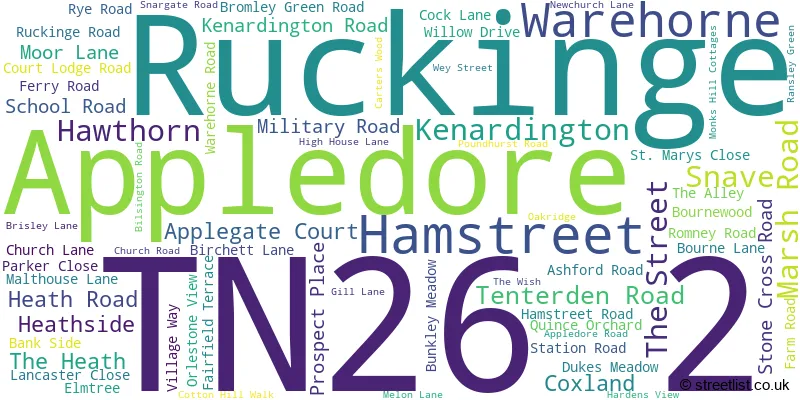
The largest settlement in the TN26 2 postal code is Hamstreet followed by Ruckinge, and Appledore.
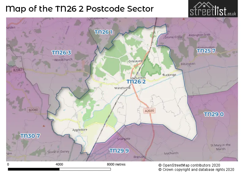
The TN26 2 Postcode shares a border with TN30 7 (TENTERDEN, Wittersham, Stone), TN25 7 (Aldington, Kingsnorth, Finberry), TN26 1 (Shadoxhurst, Hothfield, Great Chart), TN26 3 (Bethersden, Woodchurch, High Halden), TN29 0 (Dymchurch, St. Marys Bay, Burmarsh) and TN29 9 (Lydd, Lydd On Sea, Brookland).
The sector is within the post town of ASHFORD.
TN26 2 is a postcode sector within the TN26 postcode district which is within the TN Tonbridge postcode area.
The Royal Mail delivery office for the TN26 2 postal sector is the Ashford (tn) Delivery Office and Appledelivery Officere Scale Payment Delivery Office.
The area of the TN26 2 postcode sector is 24.75 square miles which is 64.10 square kilometres or 15,840.58 square acres.
The TN26 2 postcode sector is crossed by the A2070 Major A road.
Waterways within the TN26 2 postcode sector include the Royal Military Canal.

Map of the TN26 2 Postcode Sector
Explore the TN26 2 postcode sector by using our free interactive map.
| T | N | 2 | 6 | - | 2 | X | X |
| T | N | 2 | 6 | Space | 2 | Letter | Letter |
Official List of Streets
Kenardington (5 Streets)
Appledore (16 Streets)
Hamstreet (27 Streets)
Ruckinge (13 Streets)
Warehorne (7 Streets)
Snave (1 Streets)
Unofficial Streets or Alternative Spellings
Ivychurch
MELON LANE NEWCHURCH LANESnargate
HAM MILL LANETENTERDEN
READING STREETShadoxhurst
CHURCH LANEWeather Forecast for TN26 2
Press Button to Show Forecast for Warehorne
| Time Period | Icon | Description | Temperature | Rain Probability | Wind |
|---|---|---|---|---|---|
| 21:00 to 00:00 | Cloudy | 7.0°C (feels like 6.0°C) | 45.00% | ENE 4 mph |
Press Button to Show Forecast for Warehorne
| Time Period | Icon | Description | Temperature | Rain Probability | Wind |
|---|---|---|---|---|---|
| 00:00 to 03:00 | Overcast | 6.0°C (feels like 5.0°C) | 11.00% | NE 4 mph | |
| 03:00 to 06:00 | Overcast | 6.0°C (feels like 3.0°C) | 42.00% | NE 7 mph | |
| 06:00 to 09:00 | Overcast | 6.0°C (feels like 3.0°C) | 10.00% | NE 7 mph | |
| 09:00 to 12:00 | Overcast | 8.0°C (feels like 5.0°C) | 12.00% | ENE 9 mph | |
| 12:00 to 15:00 | Overcast | 9.0°C (feels like 7.0°C) | 15.00% | E 9 mph | |
| 15:00 to 18:00 | Cloudy | 10.0°C (feels like 8.0°C) | 12.00% | E 9 mph | |
| 18:00 to 21:00 | Cloudy | 9.0°C (feels like 7.0°C) | 10.00% | ENE 7 mph | |
| 21:00 to 00:00 | Cloudy | 6.0°C (feels like 4.0°C) | 13.00% | ENE 7 mph |
Press Button to Show Forecast for Warehorne
| Time Period | Icon | Description | Temperature | Rain Probability | Wind |
|---|---|---|---|---|---|
| 00:00 to 03:00 | Cloudy | 7.0°C (feels like 4.0°C) | 18.00% | ENE 7 mph | |
| 03:00 to 06:00 | Overcast | 7.0°C (feels like 5.0°C) | 22.00% | ENE 7 mph | |
| 06:00 to 09:00 | Overcast | 8.0°C (feels like 6.0°C) | 20.00% | E 9 mph | |
| 09:00 to 12:00 | Cloudy | 11.0°C (feels like 9.0°C) | 14.00% | ESE 11 mph | |
| 12:00 to 15:00 | Cloudy | 13.0°C (feels like 11.0°C) | 16.00% | ESE 11 mph | |
| 15:00 to 18:00 | Light rain shower (day) | 12.0°C (feels like 10.0°C) | 36.00% | E 11 mph | |
| 18:00 to 21:00 | Light rain | 11.0°C (feels like 9.0°C) | 45.00% | ENE 11 mph | |
| 21:00 to 00:00 | Light rain | 10.0°C (feels like 8.0°C) | 51.00% | E 11 mph |
Press Button to Show Forecast for Warehorne
| Time Period | Icon | Description | Temperature | Rain Probability | Wind |
|---|---|---|---|---|---|
| 00:00 to 03:00 | Heavy rain | 11.0°C (feels like 8.0°C) | 75.00% | ESE 11 mph | |
| 03:00 to 06:00 | Light rain shower (night) | 10.0°C (feels like 8.0°C) | 39.00% | SE 13 mph | |
| 06:00 to 09:00 | Cloudy | 11.0°C (feels like 8.0°C) | 19.00% | SSE 13 mph | |
| 09:00 to 12:00 | Light rain shower (day) | 11.0°C (feels like 8.0°C) | 40.00% | SSE 16 mph | |
| 12:00 to 15:00 | Light rain shower (day) | 13.0°C (feels like 9.0°C) | 40.00% | SSW 18 mph | |
| 15:00 to 18:00 | Light rain shower (day) | 13.0°C (feels like 11.0°C) | 36.00% | SSW 16 mph | |
| 18:00 to 21:00 | Partly cloudy (day) | 12.0°C (feels like 9.0°C) | 14.00% | SSW 13 mph | |
| 21:00 to 00:00 | Cloudy | 10.0°C (feels like 8.0°C) | 8.00% | SW 9 mph |
Schools and Places of Education Within the TN26 2 Postcode Sector
Hamstreet Primary Academy
Academy converter
Hamstreet, Ashford, Kent, TN26 2EA
Head: Mrs Helen Glancy
Ofsted Rating: Good
Inspection: 2023-05-18 (343 days ago)
Website: Visit Hamstreet Primary Academy Website
Phone: 01233732577
Number of Pupils: 269
House Prices in the TN26 2 Postcode Sector
| Type of Property | 2018 Average | 2018 Sales | 2017 Average | 2017 Sales | 2016 Average | 2016 Sales | 2015 Average | 2015 Sales |
|---|---|---|---|---|---|---|---|---|
| Detached | £542,024 | 32 | £557,772 | 21 | £540,808 | 34 | £475,256 | 41 |
| Semi-Detached | £289,500 | 15 | £260,056 | 18 | £263,660 | 20 | £249,288 | 21 |
| Terraced | £265,333 | 12 | £258,438 | 8 | £253,206 | 17 | £237,291 | 26 |
| Flats | £195,000 | 1 | £0 | 0 | £0 | 0 | £0 | 0 |
Important Postcodes TN26 2 in the Postcode Sector
TN26 2EA is the postcode for HAMSTREET PRIMARY ACADEMY, ASHFORD ROAD, HAMSTREET, Hamstreet Primary Academy, Ashford Road, and Ham Street Primary School, Hamstreet
TN26 2NJ is the postcode for The Surgery, Ruckinge Road
| The TN26 2 Sector is within these Local Authorities |
|
|---|---|
| The TN26 2 Sector is within these Counties |
|
| The TN26 2 Sector is within these Water Company Areas |
|