The TN26 3 postcode sector is within the county of Kent.
Did you know? According to the 2021 Census, the TN26 3 postcode sector is home to a bustling 5,562 residents!
Given that each sector allows for 400 unique postcode combinations. Letters C, I, K, M, O and V are not allowed in the last two letters of a postcode. With 218 postcodes already in use, this leaves 182 units available.
The largest settlement in the TN26 3 postal code is Bethersden followed by Woodchurch, and High Halden.
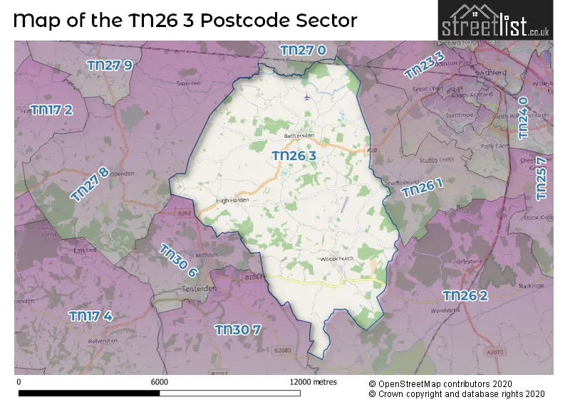
The TN26 3 Postcode shares a border with TN27 0 (Charing, Pluckley, Charing Heath), TN30 6 (TENTERDEN, St. Michaels), TN30 7 (TENTERDEN, Wittersham, Stone), TN26 1 (Shadoxhurst, Hothfield, Great Chart), TN26 2 (Hamstreet, Ruckinge, Appledore) and TN27 8 (Biddenden, Smarden).
The sector is within the post town of ASHFORD.
TN26 3 is a postcode sector within the TN26 postcode district which is within the TN Tonbridge postcode area.
The Royal Mail delivery office for the TN26 3 postal sector is the Ashford (tn) Delivery Office and Bethersden Scale Payment Delivery Office and Woodchurch Scale Payment Delivery Office.
The area of the TN26 3 postcode sector is 27.44 square miles which is 71.07 square kilometres or 17,561.88 square acres.

Map of the TN26 3 Postcode Sector
Explore the TN26 3 postcode sector by using our free interactive map.
| T | N | 2 | 6 | - | 3 | X | X |
| T | N | 2 | 6 | Space | 3 | Letter | Letter |
Official List of Streets
Woodchurch (25 Streets)
Bethersden (31 Streets)
High Halden (19 Streets)
Unofficial Streets or Alternative Spellings
Appledore
MOOR LANEGreat Chart
PARK LANEShadoxhurst
BETHERSDEN ROAD WOODCHURCH ROADTENTERDEN
WOODCHURCH ROADSt. Michaels
BIDDENDEN ROAD SWAIN ROADBiddenden
HIGH HALDEN ROADWeather Forecast for TN26 3
Press Button to Show Forecast for Bethersden
| Time Period | Icon | Description | Temperature | Rain Probability | Wind |
|---|---|---|---|---|---|
| 12:00 to 15:00 | Cloudy | 11.0°C (feels like 9.0°C) | 30.00% | W 11 mph | |
| 15:00 to 18:00 | Cloudy | 10.0°C (feels like 8.0°C) | 54.00% | W 11 mph | |
| 18:00 to 21:00 | Light rain | 8.0°C (feels like 7.0°C) | 45.00% | NW 4 mph | |
| 21:00 to 00:00 | Light rain | 7.0°C (feels like 5.0°C) | 50.00% | NE 4 mph |
Press Button to Show Forecast for Bethersden
| Time Period | Icon | Description | Temperature | Rain Probability | Wind |
|---|---|---|---|---|---|
| 00:00 to 03:00 | Overcast | 6.0°C (feels like 4.0°C) | 44.00% | NE 4 mph | |
| 03:00 to 06:00 | Cloudy | 5.0°C (feels like 3.0°C) | 9.00% | NE 7 mph | |
| 06:00 to 09:00 | Cloudy | 6.0°C (feels like 3.0°C) | 7.00% | NE 7 mph | |
| 09:00 to 12:00 | Cloudy | 8.0°C (feels like 5.0°C) | 11.00% | ENE 9 mph | |
| 12:00 to 15:00 | Overcast | 9.0°C (feels like 7.0°C) | 15.00% | ENE 9 mph | |
| 15:00 to 18:00 | Cloudy | 9.0°C (feels like 8.0°C) | 12.00% | ENE 9 mph | |
| 18:00 to 21:00 | Cloudy | 8.0°C (feels like 6.0°C) | 10.00% | ENE 7 mph | |
| 21:00 to 00:00 | Cloudy | 6.0°C (feels like 3.0°C) | 13.00% | ENE 7 mph |
Press Button to Show Forecast for Bethersden
| Time Period | Icon | Description | Temperature | Rain Probability | Wind |
|---|---|---|---|---|---|
| 00:00 to 03:00 | Cloudy | 6.0°C (feels like 3.0°C) | 18.00% | ENE 7 mph | |
| 03:00 to 06:00 | Cloudy | 6.0°C (feels like 4.0°C) | 19.00% | ENE 7 mph | |
| 06:00 to 09:00 | Overcast | 7.0°C (feels like 5.0°C) | 21.00% | ENE 7 mph | |
| 09:00 to 12:00 | Cloudy | 11.0°C (feels like 9.0°C) | 14.00% | E 9 mph | |
| 12:00 to 15:00 | Cloudy | 12.0°C (feels like 10.0°C) | 16.00% | E 11 mph | |
| 15:00 to 18:00 | Cloudy | 12.0°C (feels like 9.0°C) | 20.00% | E 11 mph | |
| 18:00 to 21:00 | Light rain | 10.0°C (feels like 8.0°C) | 49.00% | ENE 11 mph | |
| 21:00 to 00:00 | Light rain | 10.0°C (feels like 8.0°C) | 53.00% | ENE 11 mph |
Press Button to Show Forecast for Bethersden
| Time Period | Icon | Description | Temperature | Rain Probability | Wind |
|---|---|---|---|---|---|
| 00:00 to 03:00 | Heavy rain | 10.0°C (feels like 8.0°C) | 72.00% | ESE 9 mph | |
| 03:00 to 06:00 | Light rain | 10.0°C (feels like 7.0°C) | 49.00% | SE 11 mph | |
| 06:00 to 09:00 | Cloudy | 10.0°C (feels like 8.0°C) | 19.00% | SSE 11 mph | |
| 09:00 to 12:00 | Light rain shower (day) | 11.0°C (feels like 8.0°C) | 41.00% | S 16 mph | |
| 12:00 to 15:00 | Light rain shower (day) | 13.0°C (feels like 9.0°C) | 41.00% | SSW 18 mph | |
| 15:00 to 18:00 | Light rain shower (day) | 13.0°C (feels like 11.0°C) | 36.00% | SSW 16 mph | |
| 18:00 to 21:00 | Partly cloudy (day) | 12.0°C (feels like 10.0°C) | 14.00% | SSW 11 mph | |
| 21:00 to 00:00 | Partly cloudy (night) | 9.0°C (feels like 7.0°C) | 7.00% | SW 9 mph |
Schools and Places of Education Within the TN26 3 Postcode Sector
Bethersden Primary School
Community school
School Road, Ashford, Kent, TN26 3AH
Head: Ms Rebecca Heaton
Ofsted Rating: Good
Inspection: 2023-06-08 (322 days ago)
Website: Visit Bethersden Primary School Website
Phone: 01233820479
Number of Pupils: 131
High Halden Church of England Primary School
Voluntary controlled school
Church Hill, Ashford, Kent, TN26 3JB
Head: Mrs Kelly Burlton
Ofsted Rating: Good
Inspection: 2022-02-24 (791 days ago)
Website: Visit High Halden Church of England Primary School Website
Phone: 01233850285
Number of Pupils: 102
Woodchurch Church of England Primary School
Voluntary controlled school
Bethersden Road, Ashford, Kent, TN26 3QJ
Head: Mrs Kelly Burlton
Ofsted Rating: Good
Inspection: 2023-05-17 (344 days ago)
Website: Visit Woodchurch Church of England Primary School Website
Phone: 01233860232
Number of Pupils: 157
House Prices in the TN26 3 Postcode Sector
| Type of Property | 2018 Average | 2018 Sales | 2017 Average | 2017 Sales | 2016 Average | 2016 Sales | 2015 Average | 2015 Sales |
|---|---|---|---|---|---|---|---|---|
| Detached | £640,052 | 42 | £520,607 | 36 | £552,477 | 45 | £486,497 | 53 |
| Semi-Detached | £311,000 | 11 | £329,725 | 20 | £317,730 | 15 | £314,121 | 16 |
| Terraced | £268,375 | 8 | £239,604 | 12 | £232,438 | 8 | £216,269 | 13 |
| Flats | £0 | 0 | £122,500 | 1 | £204,500 | 1 | £101,500 | 2 |
Important Postcodes TN26 3 in the Postcode Sector
TN26 3AH is the postcode for Bethersden Cp School, School Road, and ASSEMBLY HALL BLOCK, Bethersden Cp School, School Road
TN26 3JB is the postcode for High Halden C of E Primary School, High Halden
TN26 3QJ is the postcode for MAIN SCHOOL BUILDING, Woodchurch C of E Primary School, Bethersden Road
TN26 3SN is the postcode for Woodchurch Care Home, Woodchurch House, Brook Street
| The TN26 3 Sector is within these Local Authorities |
|
|---|---|
| The TN26 3 Sector is within these Counties |
|
| The TN26 3 Sector is within these Water Company Areas |
|
Tourist Attractions within the TN26 3 Postcode Area
We found 1 visitor attractions within the TN26 postcode area
| Rare Breeds Centre |
|---|
| Farms |
| Farm / Rare Breeds / Farm Animals |
| View Rare Breeds Centre on Google Maps |