The TN27 8 postcode sector is within the county of Kent.
Did you know? According to the 2021 Census, the TN27 8 postcode sector is home to a bustling 4,331 residents!
Given that each sector allows for 400 unique postcode combinations. Letters C, I, K, M, O and V are not allowed in the last two letters of a postcode. With 187 postcodes already in use, this leaves 213 units available.
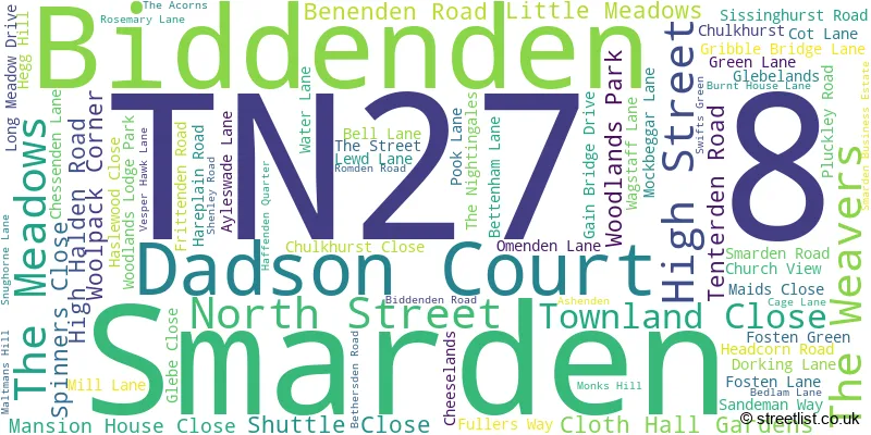
The largest settlements in the TN27 8 postal code are Biddenden and Smarden.
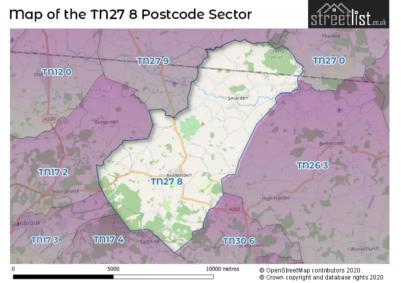
The TN27 8 Postcode shares a border with TN27 0 (Charing, Pluckley, Charing Heath), TN30 6 (TENTERDEN, St. Michaels), TN26 3 (Bethersden, Woodchurch, High Halden), TN17 2 (Frittenden, Sissinghurst, CRANBROOK), TN17 3 (CRANBROOK, Golford), TN17 4 (Benenden, Rolvenden, Rolvenden Layne) and TN27 9 (Headcorn, Egerton).
The sector is within the post town of ASHFORD.
TN27 8 is a postcode sector within the TN27 postcode district which is within the TN Tonbridge postcode area.
The Royal Mail delivery office for the TN27 8 postal sector is the Smarden Scale Payment Delivery Office and Ashford (tn) Delivery Office.
The area of the TN27 8 postcode sector is 19.60 square miles which is 50.76 square kilometres or 12,541.99 square acres.
Waterways within the TN27 8 postcode sector include the Beult, Hammer Stream, Sherway.

Map of the TN27 8 Postcode Sector
Explore the TN27 8 postcode sector by using our free interactive map.
| T | N | 2 | 7 | - | 8 | X | X |
| T | N | 2 | 7 | Space | 8 | Letter | Letter |
Official List of Streets
Smarden (34 Streets)
Biddenden (37 Streets)
Unofficial Streets or Alternative Spellings
Biddenden
WOOLPACK CORNER BEECH WALK BENENEDEN ROAD BEULT MEADOW CEDAR LANE DIGDOG LANE GAIN BRIDGE LIME GROVE MARLEY LANE OAK AVENUE OLD MILL COURT SHERWAY ROAD SMARDEN BELL ROAD THE CUT THE GREEN VESPER COURT WEEKS LANE WILLOW WAYBethersden
BETHERSDEN ROAD WISSENDEN LANEEgerton
BEDLAM LANEHeadcorn
BIDDENDEN ROAD BLETCHENDEN ROAD LOVE LANE SMARDEN ROADTENTERDEN
CRANBROOK ROADBenenden
FROGS HOLE LANEWeather Forecast for TN27 8
Press Button to Show Forecast for Three Chimneys
| Time Period | Icon | Description | Temperature | Rain Probability | Wind |
|---|---|---|---|---|---|
| 15:00 to 18:00 | Cloudy | 13.0°C (feels like 11.0°C) | 3.00% | W 9 mph | |
| 18:00 to 21:00 | Cloudy | 10.0°C (feels like 7.0°C) | 5.00% | SW 13 mph | |
| 21:00 to 00:00 | Cloudy | 9.0°C (feels like 6.0°C) | 12.00% | WSW 11 mph |
Press Button to Show Forecast for Three Chimneys
| Time Period | Icon | Description | Temperature | Rain Probability | Wind |
|---|---|---|---|---|---|
| 00:00 to 03:00 | Light rain | 8.0°C (feels like 5.0°C) | 48.00% | WSW 13 mph | |
| 03:00 to 06:00 | Overcast | 8.0°C (feels like 5.0°C) | 15.00% | W 13 mph | |
| 06:00 to 09:00 | Overcast | 9.0°C (feels like 7.0°C) | 19.00% | WNW 13 mph | |
| 09:00 to 12:00 | Cloudy | 11.0°C (feels like 8.0°C) | 15.00% | NW 16 mph | |
| 12:00 to 15:00 | Cloudy | 12.0°C (feels like 9.0°C) | 16.00% | NW 16 mph | |
| 15:00 to 18:00 | Cloudy | 11.0°C (feels like 8.0°C) | 31.00% | N 13 mph | |
| 18:00 to 21:00 | Cloudy | 9.0°C (feels like 7.0°C) | 10.00% | N 9 mph | |
| 21:00 to 00:00 | Clear night | 6.0°C (feels like 3.0°C) | 3.00% | N 9 mph |
Press Button to Show Forecast for Three Chimneys
| Time Period | Icon | Description | Temperature | Rain Probability | Wind |
|---|---|---|---|---|---|
| 00:00 to 03:00 | Clear night | 4.0°C (feels like 1.0°C) | 1.00% | NNW 9 mph | |
| 03:00 to 06:00 | Cloudy | 4.0°C (feels like 0.0°C) | 4.00% | NNW 11 mph | |
| 06:00 to 09:00 | Overcast | 4.0°C (feels like 0.0°C) | 8.00% | NNW 11 mph | |
| 09:00 to 12:00 | Overcast | 8.0°C (feels like 4.0°C) | 8.00% | N 13 mph | |
| 12:00 to 15:00 | Overcast | 9.0°C (feels like 6.0°C) | 9.00% | N 13 mph | |
| 15:00 to 18:00 | Overcast | 10.0°C (feels like 7.0°C) | 10.00% | N 11 mph | |
| 18:00 to 21:00 | Cloudy | 8.0°C (feels like 6.0°C) | 5.00% | NNE 9 mph | |
| 21:00 to 00:00 | Cloudy | 6.0°C (feels like 3.0°C) | 4.00% | N 7 mph |
Press Button to Show Forecast for Three Chimneys
| Time Period | Icon | Description | Temperature | Rain Probability | Wind |
|---|---|---|---|---|---|
| 00:00 to 03:00 | Overcast | 4.0°C (feels like 2.0°C) | 8.00% | N 7 mph | |
| 03:00 to 06:00 | Cloudy | 4.0°C (feels like 1.0°C) | 5.00% | NNW 7 mph | |
| 06:00 to 09:00 | Overcast | 5.0°C (feels like 2.0°C) | 8.00% | NNW 7 mph | |
| 09:00 to 12:00 | Overcast | 8.0°C (feels like 5.0°C) | 9.00% | N 11 mph | |
| 12:00 to 15:00 | Overcast | 9.0°C (feels like 7.0°C) | 11.00% | NNE 11 mph | |
| 15:00 to 18:00 | Overcast | 10.0°C (feels like 7.0°C) | 11.00% | NNE 11 mph | |
| 18:00 to 21:00 | Cloudy | 8.0°C (feels like 6.0°C) | 7.00% | NE 11 mph | |
| 21:00 to 00:00 | Partly cloudy (night) | 6.0°C (feels like 3.0°C) | 4.00% | NNE 9 mph |
Press Button to Show Forecast for Three Chimneys
| Time Period | Icon | Description | Temperature | Rain Probability | Wind |
|---|---|---|---|---|---|
| 00:00 to 03:00 | Partly cloudy (night) | 5.0°C (feels like 2.0°C) | 4.00% | N 9 mph | |
| 03:00 to 06:00 | Overcast | 5.0°C (feels like 2.0°C) | 8.00% | N 9 mph | |
| 06:00 to 09:00 | Partly cloudy (day) | 5.0°C (feels like 2.0°C) | 3.00% | N 9 mph | |
| 09:00 to 12:00 | Cloudy | 9.0°C (feels like 6.0°C) | 8.00% | NNE 13 mph | |
| 12:00 to 15:00 | Cloudy | 10.0°C (feels like 7.0°C) | 10.00% | NE 13 mph | |
| 15:00 to 18:00 | Partly cloudy (day) | 10.0°C (feels like 7.0°C) | 4.00% | NE 13 mph | |
| 18:00 to 21:00 | Sunny day | 8.0°C (feels like 5.0°C) | 2.00% | NE 11 mph | |
| 21:00 to 00:00 | Partly cloudy (night) | 6.0°C (feels like 3.0°C) | 1.00% | NNE 9 mph |
Schools and Places of Education Within the TN27 8 Postcode Sector
Greenfields School
Other independent special school
Tenterden Road, Ashford, Kent, TN27 8BE
Head: Mrs Kelly Cartwright
Ofsted Rating: Good
Inspection: 2021-10-14 (917 days ago)
Website: Visit Greenfields School Website
Phone: 01580292523
Number of Pupils: 15
Smarden Primary School
Academy converter
Pluckley Road, Ashford, Kent, TN27 8ND
Head: Mrs Claudia Miller
Ofsted Rating: Good
Inspection: 2023-05-11 (343 days ago)
Website: Visit Smarden Primary School Website
Phone: 01233770316
Number of Pupils: 174
House Prices in the TN27 8 Postcode Sector
| Type of Property | 2018 Average | 2018 Sales | 2017 Average | 2017 Sales | 2016 Average | 2016 Sales | 2015 Average | 2015 Sales |
|---|---|---|---|---|---|---|---|---|
| Detached | £603,096 | 38 | £556,114 | 18 | £603,229 | 26 | £654,638 | 29 |
| Semi-Detached | £462,611 | 9 | £353,395 | 13 | £317,448 | 20 | £342,619 | 13 |
| Terraced | £263,667 | 6 | £282,667 | 6 | £336,617 | 9 | £429,750 | 6 |
| Flats | £153,667 | 3 | £305,000 | 1 | £107,000 | 1 | £0 | 0 |
Important Postcodes TN27 8 in the Postcode Sector
TN27 8AL is the postcode for John Mayne C of E Primary School, High Street
TN27 8ND is the postcode for Smarden Cp School, Pluckley Road
| The TN27 8 Sector is within these Local Authorities |
|
|---|---|
| The TN27 8 Sector is within these Counties |
|
| The TN27 8 Sector is within these Water Company Areas |
|
Tourist Attractions within the TN27 8 Postcode Area
We found 1 visitor attractions within the TN27 postcode area
| Standen |
|---|
| Historic Properties |
| Historic House / House and Garden / Palace |
| View Standen on Google Maps |