The TW11 8 postcode sector is within the county of Greater London.
Did you know? According to the 2021 Census, the TW11 8 postcode sector is home to a bustling 8,346 residents!
Given that each sector allows for 400 unique postcode combinations. Letters C, I, K, M, O and V are not allowed in the last two letters of a postcode. With 196 postcodes already in use, this leaves 204 units available.
The TW11 8 postal code covers the settlement of TEDDINGTON .
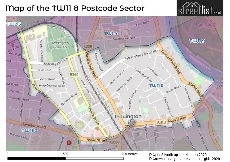
The TW11 8 Postcode shares a border with TW1 4 (TWICKENHAM ), TW2 5 (TWICKENHAM ), TW11 0 (TEDDINGTON ) and TW11 9 (TEDDINGTON ).
The sector is within the post town of TEDDINGTON.
TW11 8 is a postcode sector within the TW11 postcode district which is within the TW Twickenham postcode area.
The Royal Mail delivery office for the TW11 8 postal sector is the Teddington Delivery Office.
The area of the TW11 8 postcode sector is 0.41 square miles which is 1.06 square kilometres or 261.80 square acres.

Map of the TW11 8 Postcode Sector
Explore the TW11 8 postcode sector by using our free interactive map.
| T | W | 1 | 1 | - | 8 | X | X |
| T | W | 1 | 1 | Space | 8 | Letter | Letter |
Official List of Streets
TEDDINGTON (65 Streets)
Unofficial Streets or Alternative Spellings
TEDDINGTON
CEDAR ROAD CLONMEL ROAD ELLERAY ROAD FERRY ROAD FIELD LANE FULWELL ROAD GLOUCESTER ROAD KINGSTON LANE LANGHAM ROAD NORTH LANE PRINCES ROAD QUEENS ROAD UDNEY PARK ROAD WILCOX ROAD WINCHENDON ROAD ARLINGTON PASSAGE BEVERLEY COURT CHERRYWOOD COURT HALL COURT QUEENS ROAD SAINT ALBANS GARDENS TRAHERNE LODGEHampton Hill
HAMPTON ROADTWICKENHAM
FIELDEND STRAWBERRY VALETEDDINGTON,
STANLEY ROAD WALDEGRAVE ROADWeather Forecast for TW11 8
Press Button to Show Forecast for Rugby Football Union Twickenham
| Time Period | Icon | Description | Temperature | Rain Probability | Wind |
|---|---|---|---|---|---|
| 06:00 to 09:00 | Cloudy | 6.0°C (feels like 3.0°C) | 4.00% | NNW 7 mph | |
| 09:00 to 12:00 | Cloudy | 8.0°C (feels like 5.0°C) | 4.00% | NNW 11 mph | |
| 12:00 to 15:00 | Cloudy | 10.0°C (feels like 8.0°C) | 4.00% | N 11 mph | |
| 15:00 to 18:00 | Cloudy | 11.0°C (feels like 9.0°C) | 4.00% | NNW 9 mph | |
| 18:00 to 21:00 | Cloudy | 10.0°C (feels like 9.0°C) | 4.00% | N 7 mph | |
| 21:00 to 00:00 | Partly cloudy (night) | 8.0°C (feels like 7.0°C) | 0.00% | NNE 4 mph |
Press Button to Show Forecast for Rugby Football Union Twickenham
| Time Period | Icon | Description | Temperature | Rain Probability | Wind |
|---|---|---|---|---|---|
| 00:00 to 03:00 | Cloudy | 7.0°C (feels like 5.0°C) | 3.00% | SE 4 mph | |
| 03:00 to 06:00 | Cloudy | 6.0°C (feels like 4.0°C) | 4.00% | WSW 4 mph | |
| 06:00 to 09:00 | Cloudy | 6.0°C (feels like 4.0°C) | 5.00% | WSW 4 mph | |
| 09:00 to 12:00 | Cloudy | 9.0°C (feels like 7.0°C) | 5.00% | W 7 mph | |
| 12:00 to 15:00 | Overcast | 11.0°C (feels like 10.0°C) | 12.00% | WNW 9 mph | |
| 15:00 to 18:00 | Cloudy | 12.0°C (feels like 10.0°C) | 10.00% | WNW 9 mph | |
| 18:00 to 21:00 | Cloudy | 11.0°C (feels like 10.0°C) | 10.00% | NW 7 mph | |
| 21:00 to 00:00 | Cloudy | 10.0°C (feels like 8.0°C) | 8.00% | N 4 mph |
Press Button to Show Forecast for Rugby Football Union Twickenham
| Time Period | Icon | Description | Temperature | Rain Probability | Wind |
|---|---|---|---|---|---|
| 00:00 to 03:00 | Cloudy | 8.0°C (feels like 7.0°C) | 5.00% | NNE 4 mph | |
| 03:00 to 06:00 | Cloudy | 7.0°C (feels like 5.0°C) | 6.00% | ENE 4 mph | |
| 06:00 to 09:00 | Cloudy | 6.0°C (feels like 5.0°C) | 10.00% | E 4 mph | |
| 09:00 to 12:00 | Cloudy | 9.0°C (feels like 7.0°C) | 12.00% | ESE 7 mph | |
| 12:00 to 15:00 | Overcast | 11.0°C (feels like 9.0°C) | 17.00% | SE 7 mph | |
| 15:00 to 18:00 | Overcast | 11.0°C (feels like 10.0°C) | 23.00% | SE 7 mph | |
| 18:00 to 21:00 | Cloudy | 11.0°C (feels like 9.0°C) | 15.00% | SE 7 mph | |
| 21:00 to 00:00 | Cloudy | 9.0°C (feels like 8.0°C) | 12.00% | SE 7 mph |
Press Button to Show Forecast for Rugby Football Union Twickenham
| Time Period | Icon | Description | Temperature | Rain Probability | Wind |
|---|---|---|---|---|---|
| 00:00 to 03:00 | Cloudy | 8.0°C (feels like 7.0°C) | 15.00% | ESE 7 mph | |
| 03:00 to 06:00 | Cloudy | 8.0°C (feels like 6.0°C) | 17.00% | ESE 7 mph | |
| 06:00 to 09:00 | Cloudy | 8.0°C (feels like 6.0°C) | 18.00% | E 7 mph | |
| 09:00 to 12:00 | Cloudy | 10.0°C (feels like 9.0°C) | 14.00% | SE 7 mph | |
| 12:00 to 15:00 | Cloudy | 12.0°C (feels like 11.0°C) | 15.00% | ESE 9 mph | |
| 15:00 to 18:00 | Cloudy | 13.0°C (feels like 11.0°C) | 18.00% | ESE 9 mph | |
| 18:00 to 21:00 | Cloudy | 13.0°C (feels like 11.0°C) | 18.00% | E 9 mph | |
| 21:00 to 00:00 | Cloudy | 11.0°C (feels like 10.0°C) | 18.00% | ESE 7 mph |
Schools and Places of Education Within the TW11 8 Postcode Sector
St Mary's and St Peter's Church of England Primary School
Voluntary aided school
Somerset Road, Teddington, , TW11 8RX
Head: Ms Helen Swain
Ofsted Rating: Outstanding
Inspection: 2022-12-08 (503 days ago)
Website: Visit St Mary's and St Peter's Church of England Primary School Website
Phone: 02089430476
Number of Pupils: 610
Stanley Primary School
Community school
Strathmore Road, Teddington, Middlesex, TW11 8UH
Head: Mr Simon Hawley
Ofsted Rating: Good
Inspection: 2019-03-13 (1869 days ago)
Website: Visit Stanley Primary School Website
Phone: 02089774858
Number of Pupils: 519
House Prices in the TW11 8 Postcode Sector
| Type of Property | 2018 Average | 2018 Sales | 2017 Average | 2017 Sales | 2016 Average | 2016 Sales | 2015 Average | 2015 Sales |
|---|---|---|---|---|---|---|---|---|
| Detached | £1,176,750 | 4 | £1,330,000 | 5 | £1,389,500 | 10 | £1,375,555 | 10 |
| Semi-Detached | £966,569 | 18 | £1,028,452 | 22 | £1,049,750 | 16 | £873,282 | 28 |
| Terraced | £740,816 | 49 | £744,847 | 49 | £738,418 | 72 | £695,491 | 75 |
| Flats | £401,216 | 47 | £446,819 | 56 | £520,653 | 86 | £405,162 | 67 |
Important Postcodes TW11 8 in the Postcode Sector
TW11 8EG is the postcode for Royal Mail, Teddington Delivery Office, 19 High Street
TW11 8EZ is the postcode for Teddington Pool & Fitness Centre, Vicarage Road, TEDDINGTON SWIMMING POOL, VICARAGE ROAD, TEDDINGTON, and Teddington Swimming Pool, Vicarage Road
TW11 8GT is the postcode for 8 Waldegrave Road
TW11 8HU is the postcode for Richmond & Twickenham Primary Care Trust, Thames House, 180-194 High Street, THAMES HOUSE, 180-194 HIGH STREET, TEDDINGTON, and Thames House, 180-194 High Street
TW11 8LA is the postcode for St. Marys University, Naylor Library, 99 Waldegrave Road
TW11 8NY is the postcode for Teddington Library, Waldegrave Road
TW11 8QL is the postcode for Maddison Centre, 140 Church Road
TW11 8RX is the postcode for A - MAIN SCHOOL ST MARY'S AND ST PETER'S CE PRIMARY SCHOOL, St Mary's and St Peter's CE Primary School, Somerset Road, St Mary's and St Peters Pre-School, Somerset Road, and St Mary's and St Peter's CE Primary School, Main School, Sommerset Road
TW11 8UE is the postcode for A - MAIN BLOCK, Stanley Junior School, Stanley Road, A - MAIN SCHOOL STANLEY INFANT AND NURSERY SCHOOL, Stanley Infant School, Strathmore Road, and B - SWIMMING POOL BLOCK, Stanley Junior School, Stanley Road
TW11 8UH is the postcode for Autistic Hub, Stanley Primary School, Strathmore Road, C - SWIMMING POOL BLOCK, Stanley Primary School, Strathmore Road, BLOCK 2, Stanley Primary School, Strathmore Road, SWIMMING POOL, Stanley Primary School, Strathmore Road, A - INFANT AND NURSERY BLOCK, Stanley Primary School, Strathmore Road, BLOCK 4, Stanley Primary School, Strathmore Road, NURSERY, Stanley Primary School, Strathmore Road, B - JUNIOR BLOCK, Stanley Primary School, Strathmore Road, and BLOCK 3, Stanley Primary School, Strathmore Road
| The TW11 8 Sector is within these Local Authorities |
|
|---|---|
| The TW11 8 Sector is within these Counties |
|
| The TW11 8 Sector is within these Water Company Areas |
|