The TW6 postcode district is a postal district located in the TW Twickenham postcode area with a population of 9 residents according to the 2021 England and Wales Census.
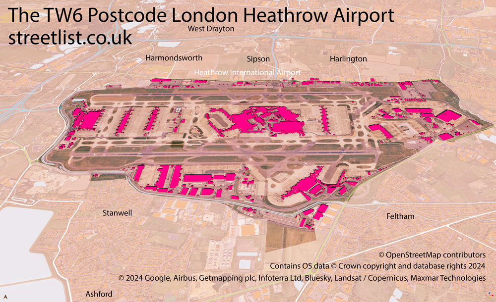
Map of the TW6 Heathrow Airport Postcode
The area of the TW6 postcode district is 4.88 square miles which is 12.64 square kilometres or 3,122.78 acres.
Currently, the TW6 district has about 127 postcode units spread across 3 geographic postcode sectors.
Given that each sector allows for 400 unique postcode combinations, the district has a capacity of 1,200 postcodes. With 127 postcodes already in use, this leaves 1073 units available.
The TW6 postal code covers the settlement of LONDON HEATHROW AIRPORT.
The TW6 Postcode shares a border with UB7 (WEST DRAYTON), TW14 (FELTHAM), TW19 (STANWELL, WRAYSBURY, STANWELL MOOR) and UB3 (HAYES).
The primary settlement in the TW6 postcode district is London Heathrow Airport. It is located in the post town of Hounslow, in the county of Greater London. Additionally, there is another significant settlement in the district, Heathrow.
For the district TW6, we have data on 3 postcode sectors. Here's a breakdown: The sector TW6 1, covers London Heathrow Airport in Greater London. The sector TW6 2, covers London Heathrow Airport in Greater London. The sector TW6 3, covers London Heathrow Airport in Greater London.

Map of the TW6 Postcode District
Explore the TW6 postcode district by using our free interactive map.

When it comes to local government, postal geography often disregards political borders. However, for a breakdown in the TW6 District: the district mostly encompasses the Hillingdon London Boro (124 postcodes), and finally, the Hounslow London Boro area (3 postcodes).
Recent House Sales in TW6
| Date | Price | Address |
|---|---|---|
| 01/06/2022 | £74,493,000 | London Heathrow Airport, Hounslow, TW6 3AF |
| 26/05/2022 | £13,750,000 | Newall Road, London Heathrow Airport, Hounslow, TW6 2SF |
| 06/12/2021 | £102,000,000 | Nelson Road, London Heathrow Airport, Hounslow, TW6 2GW |
| 01/10/2021 | £67,950,000 | Hatton Cross Centre, London Heathrow Airport, Hounslow, TW6 2GE |
| 06/07/2021 | £3,500,000 | Southern Perimeter Road, London Heathrow Airport, Hounslow, TW6 3LP |
| 23/03/2021 | £426,400 | Bath Road, Heathrow, Hounslow, TW6 2AL |
| 23/03/2021 | £2,000,000 | Newall Road, London Heathrow Airport, Hounslow, TW6 2RT |
Weather Forecast for TW6
Press Button to Show Forecast for Heathrow
| Time Period | Icon | Description | Temperature | Rain Probability | Wind |
|---|---|---|---|---|---|
| 18:00 to 21:00 | Cloudy | 11.0°C (feels like 8.0°C) | 6.00% | N 11 mph | |
| 21:00 to 00:00 | Cloudy | 8.0°C (feels like 7.0°C) | 4.00% | N 7 mph |
Press Button to Show Forecast for Heathrow
| Time Period | Icon | Description | Temperature | Rain Probability | Wind |
|---|---|---|---|---|---|
| 00:00 to 03:00 | Cloudy | 6.0°C (feels like 4.0°C) | 3.00% | NNW 7 mph | |
| 03:00 to 06:00 | Cloudy | 5.0°C (feels like 2.0°C) | 4.00% | NNW 7 mph | |
| 06:00 to 09:00 | Cloudy | 6.0°C (feels like 3.0°C) | 4.00% | NNW 9 mph | |
| 09:00 to 12:00 | Cloudy | 8.0°C (feels like 5.0°C) | 4.00% | NNW 11 mph | |
| 12:00 to 15:00 | Cloudy | 11.0°C (feels like 8.0°C) | 4.00% | N 13 mph | |
| 15:00 to 18:00 | Cloudy | 12.0°C (feels like 9.0°C) | 5.00% | N 11 mph | |
| 18:00 to 21:00 | Cloudy | 11.0°C (feels like 9.0°C) | 3.00% | N 9 mph | |
| 21:00 to 00:00 | Partly cloudy (night) | 8.0°C (feels like 7.0°C) | 0.00% | NE 4 mph |
Press Button to Show Forecast for Heathrow
| Time Period | Icon | Description | Temperature | Rain Probability | Wind |
|---|---|---|---|---|---|
| 00:00 to 03:00 | Cloudy | 7.0°C (feels like 5.0°C) | 3.00% | WSW 4 mph | |
| 03:00 to 06:00 | Partly cloudy (night) | 6.0°C (feels like 4.0°C) | 1.00% | WSW 4 mph | |
| 06:00 to 09:00 | Cloudy | 6.0°C (feels like 4.0°C) | 5.00% | W 4 mph | |
| 09:00 to 12:00 | Cloudy | 9.0°C (feels like 8.0°C) | 5.00% | WNW 9 mph | |
| 12:00 to 15:00 | Overcast | 12.0°C (feels like 10.0°C) | 11.00% | WNW 11 mph | |
| 15:00 to 18:00 | Cloudy | 13.0°C (feels like 11.0°C) | 10.00% | WNW 11 mph | |
| 18:00 to 21:00 | Cloudy | 11.0°C (feels like 10.0°C) | 10.00% | NW 9 mph | |
| 21:00 to 00:00 | Cloudy | 9.0°C (feels like 8.0°C) | 7.00% | N 7 mph |
Press Button to Show Forecast for Heathrow
| Time Period | Icon | Description | Temperature | Rain Probability | Wind |
|---|---|---|---|---|---|
| 00:00 to 03:00 | Cloudy | 8.0°C (feels like 6.0°C) | 5.00% | NNE 4 mph | |
| 03:00 to 06:00 | Cloudy | 6.0°C (feels like 5.0°C) | 6.00% | ENE 4 mph | |
| 06:00 to 09:00 | Cloudy | 6.0°C (feels like 5.0°C) | 9.00% | E 4 mph | |
| 09:00 to 12:00 | Cloudy | 9.0°C (feels like 7.0°C) | 12.00% | ESE 9 mph | |
| 12:00 to 15:00 | Overcast | 11.0°C (feels like 10.0°C) | 17.00% | SE 9 mph | |
| 15:00 to 18:00 | Overcast | 12.0°C (feels like 10.0°C) | 22.00% | SE 9 mph | |
| 18:00 to 21:00 | Cloudy | 11.0°C (feels like 9.0°C) | 15.00% | SE 9 mph | |
| 21:00 to 00:00 | Cloudy | 9.0°C (feels like 7.0°C) | 12.00% | SE 7 mph |
Press Button to Show Forecast for Heathrow
| Time Period | Icon | Description | Temperature | Rain Probability | Wind |
|---|---|---|---|---|---|
| 00:00 to 03:00 | Cloudy | 8.0°C (feels like 6.0°C) | 14.00% | ESE 7 mph | |
| 03:00 to 06:00 | Cloudy | 7.0°C (feels like 6.0°C) | 17.00% | ESE 7 mph | |
| 06:00 to 09:00 | Cloudy | 8.0°C (feels like 6.0°C) | 18.00% | E 7 mph | |
| 09:00 to 12:00 | Cloudy | 11.0°C (feels like 9.0°C) | 14.00% | SE 9 mph | |
| 12:00 to 15:00 | Cloudy | 13.0°C (feels like 11.0°C) | 15.00% | ESE 11 mph | |
| 15:00 to 18:00 | Cloudy | 13.0°C (feels like 11.0°C) | 18.00% | E 11 mph | |
| 18:00 to 21:00 | Cloudy | 12.0°C (feels like 11.0°C) | 18.00% | E 9 mph | |
| 21:00 to 00:00 | Cloudy | 11.0°C (feels like 9.0°C) | 18.00% | ESE 9 mph |
Where is the TW6 Postcode District?
The TW6 postcode district is located in Hounslow. Hounslow is a district town that is situated west of London Heathrow Airport, northwest of Heathrow, north of Sipson, southeast of Bedfont, northeast of Harlington, and southwest of Stanwell. The district is approximately 14.37 miles away from the center of London.
The district is within the post town of HOUNSLOW.
The sector has postcodes within the nation of England.
The TW6 Postcode District is covers the following regions.
- Harrow and Hillingdon - Outer London - West and North West - London
- Hounslow and Richmond upon Thames - Outer London - West and North West - London
- West Surrey - Surrey, East and West Sussex - South East (England)
| Postcode Sector | Delivery Office |
|---|---|
| TW6 1 | Hounslow Delivery Office |
| TW6 2 | Hounslow Delivery Office |
| TW6 3 | Hounslow Delivery Office |
| T | W | 6 | - | X | X | X |
| T | W | 6 | Space | Numeric | Letter | Letter |
Current Monthly Rental Prices
| # Bedrooms | Min Price | Max Price | Avg Price |
|---|
Current House Prices
| # Bedrooms | Min Price | Max Price | Avg Price |
|---|
Estate Agents who Operate in the TW6 District
| Logo | Name | Brand Name | Address | Contact Number | Total Properties |
|---|
| Type of Property | 2018 Average | 2018 Sales | 2017 Average | 2017 Sales | 2016 Average | 2016 Sales | 2015 Average | 2015 Sales |
|---|---|---|---|---|---|---|---|---|
| Detached | £0 | 0 | £0 | 0 | £0 | 0 | £0 | 0 |
| Semi-Detached | £0 | 0 | £0 | 0 | £0 | 0 | £0 | 0 |
| Terraced | £0 | 0 | £0 | 0 | £0 | 0 | £0 | 0 |
| Flats | £0 | 0 | £0 | 0 | £0 | 0 | £0 | 0 |