The UB10 9 postcode sector is within the county of Greater London.
Did you know? According to the 2021 Census, the UB10 9 postcode sector is home to a bustling 11,166 residents!
Given that each sector allows for 400 unique postcode combinations. Letters C, I, K, M, O and V are not allowed in the last two letters of a postcode. With 159 postcodes already in use, this leaves 241 units available.
The UB10 9 postal code covers the settlement of UXBRIDGE .
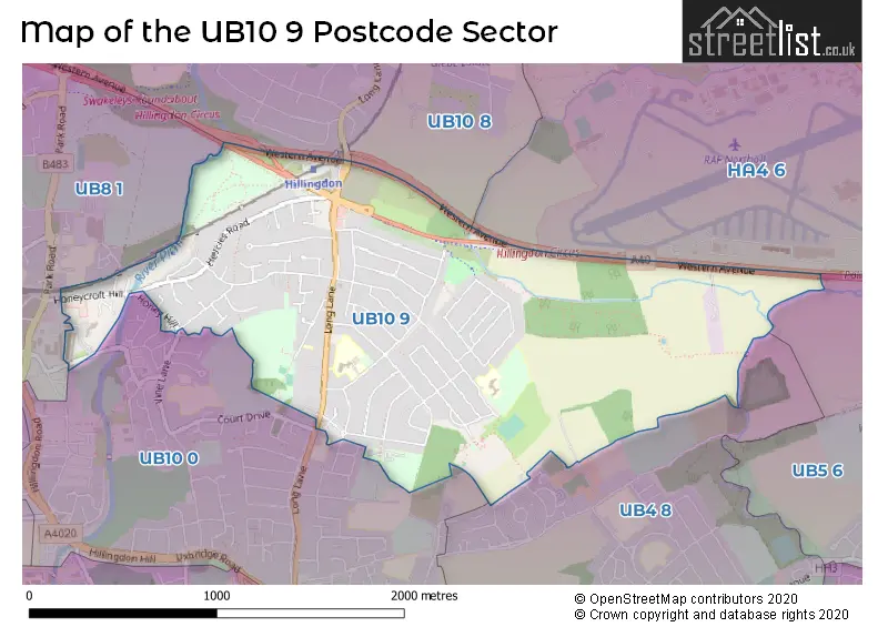
The UB10 9 Postcode shares a border with UB4 8 (HAYES ), UB8 1 (UXBRIDGE ), UB10 0 (UXBRIDGE ), UB5 6 (NORTHOLT , RUISLIP , HAYES ), UB10 8 (ICKENHAM ) and HA4 6 (RUISLIP , SOUTH RUISLIP ).
The sector is within the post town of UXBRIDGE.
UB10 9 is a postcode sector within the UB10 postcode district which is within the UB Uxbridge postcode area.
The Royal Mail delivery office for the UB10 9 postal sector is the Uxbridge Delivery Office.
The area of the UB10 9 postcode sector is 1.47 square miles which is 3.81 square kilometres or 942.11 square acres.

Map of the UB10 9 Postcode Sector
Explore the UB10 9 postcode sector by using our free interactive map.
| U | B | 1 | 0 | - | 9 | X | X |
| U | B | 1 | 0 | Space | 9 | Letter | Letter |
Official List of Streets
UXBRIDGE (57 Streets)
Unofficial Streets or Alternative Spellings
UXBRIDGE
DOWDING ROAD HORNCHURCH ROAD BADER WAY HILLINGDON TRAIL MASTERMAN PLACE OVERLORD CLOSE ST ANDREWS ROAD THE CHESTNUTSHillingdon
SNOWDEN AVENUE VINE LANEEaling
WESTERN AVENUEWeather Forecast for UB10 9
Press Button to Show Forecast for Hillingdon
| Time Period | Icon | Description | Temperature | Rain Probability | Wind |
|---|---|---|---|---|---|
| 21:00 to 00:00 | Cloudy | 8.0°C (feels like 5.0°C) | 4.00% | NNE 9 mph |
Press Button to Show Forecast for Hillingdon
| Time Period | Icon | Description | Temperature | Rain Probability | Wind |
|---|---|---|---|---|---|
| 00:00 to 03:00 | Clear night | 5.0°C (feels like 3.0°C) | 0.00% | N 7 mph | |
| 03:00 to 06:00 | Clear night | 4.0°C (feels like 1.0°C) | 0.00% | NNW 7 mph | |
| 06:00 to 09:00 | Sunny day | 4.0°C (feels like 1.0°C) | 0.00% | NNW 7 mph | |
| 09:00 to 12:00 | Partly cloudy (day) | 8.0°C (feels like 5.0°C) | 0.00% | N 13 mph | |
| 12:00 to 15:00 | Cloudy | 10.0°C (feels like 7.0°C) | 4.00% | N 13 mph | |
| 15:00 to 18:00 | Cloudy | 11.0°C (feels like 9.0°C) | 4.00% | N 11 mph | |
| 18:00 to 21:00 | Cloudy | 10.0°C (feels like 8.0°C) | 3.00% | NNE 9 mph | |
| 21:00 to 00:00 | Cloudy | 7.0°C (feels like 5.0°C) | 4.00% | NE 7 mph |
Press Button to Show Forecast for Hillingdon
| Time Period | Icon | Description | Temperature | Rain Probability | Wind |
|---|---|---|---|---|---|
| 00:00 to 03:00 | Overcast | 6.0°C (feels like 4.0°C) | 8.00% | N 4 mph | |
| 03:00 to 06:00 | Cloudy | 5.0°C (feels like 3.0°C) | 5.00% | N 7 mph | |
| 06:00 to 09:00 | Cloudy | 5.0°C (feels like 3.0°C) | 8.00% | N 7 mph | |
| 09:00 to 12:00 | Overcast | 8.0°C (feels like 5.0°C) | 8.00% | NNE 11 mph | |
| 12:00 to 15:00 | Overcast | 10.0°C (feels like 7.0°C) | 9.00% | NNE 11 mph | |
| 15:00 to 18:00 | Overcast | 11.0°C (feels like 9.0°C) | 9.00% | NNE 11 mph | |
| 18:00 to 21:00 | Partly cloudy (day) | 10.0°C (feels like 7.0°C) | 4.00% | NNE 11 mph | |
| 21:00 to 00:00 | Clear night | 7.0°C (feels like 4.0°C) | 3.00% | NNE 9 mph |
Press Button to Show Forecast for Hillingdon
| Time Period | Icon | Description | Temperature | Rain Probability | Wind |
|---|---|---|---|---|---|
| 00:00 to 03:00 | Clear night | 5.0°C (feels like 3.0°C) | 2.00% | NNE 7 mph | |
| 03:00 to 06:00 | Clear night | 4.0°C (feels like 1.0°C) | 2.00% | N 4 mph | |
| 06:00 to 09:00 | Partly cloudy (day) | 4.0°C (feels like 2.0°C) | 2.00% | NNW 4 mph | |
| 09:00 to 12:00 | Cloudy | 8.0°C (feels like 6.0°C) | 7.00% | N 4 mph | |
| 12:00 to 15:00 | Cloudy | 8.0°C (feels like 7.0°C) | 12.00% | NNW 4 mph | |
| 15:00 to 18:00 | Overcast | 9.0°C (feels like 7.0°C) | 17.00% | NW 7 mph | |
| 18:00 to 21:00 | Overcast | 9.0°C (feels like 7.0°C) | 18.00% | WNW 7 mph | |
| 21:00 to 00:00 | Light rain | 8.0°C (feels like 6.0°C) | 45.00% | NNW 7 mph |
Press Button to Show Forecast for Hillingdon
| Time Period | Icon | Description | Temperature | Rain Probability | Wind |
|---|---|---|---|---|---|
| 00:00 to 03:00 | Cloudy | 7.0°C (feels like 6.0°C) | 14.00% | NNE 4 mph | |
| 03:00 to 06:00 | Cloudy | 7.0°C (feels like 5.0°C) | 12.00% | N 7 mph | |
| 06:00 to 09:00 | Cloudy | 6.0°C (feels like 3.0°C) | 10.00% | N 7 mph | |
| 09:00 to 12:00 | Cloudy | 8.0°C (feels like 5.0°C) | 7.00% | N 11 mph | |
| 12:00 to 15:00 | Overcast | 10.0°C (feels like 8.0°C) | 15.00% | NNE 11 mph | |
| 15:00 to 18:00 | Overcast | 11.0°C (feels like 9.0°C) | 14.00% | NNE 11 mph | |
| 18:00 to 21:00 | Cloudy | 11.0°C (feels like 9.0°C) | 9.00% | NNE 9 mph | |
| 21:00 to 00:00 | Partly cloudy (night) | 8.0°C (feels like 6.0°C) | 3.00% | NNE 7 mph |
Schools and Places of Education Within the UB10 9 Postcode Sector
Oak Farm Primary School
Foundation school
Windsor Avenue, Uxbridge, , UB10 9PD
Head: Mrs Catherine Veale
Ofsted Rating: Outstanding
Inspection: 2008-03-27 (5867 days ago)
Website: Visit Oak Farm Primary School Website
Phone: 01895590375
Number of Pupils: 605
Oak Wood School
Foundation school
Sutton Court Road, Uxbridge, Middlesex, UB10 9HT
Head: Mr Daniel Cowling
Ofsted Rating: Good
Inspection: 2022-05-18 (702 days ago)
Website: Visit Oak Wood School Website
Phone: 01895237350
Number of Pupils: 1232
Ryefield Primary School
Academy converter
Ryefield Avenue, Uxbridge, Middlesex, UB10 9DE
Head: Colin Tucker
Ofsted Rating: Good
Inspection: 2023-03-29 (387 days ago)
Website: Visit Ryefield Primary School Website
Phone: 01895547036
Number of Pupils: 437
House Prices in the UB10 9 Postcode Sector
| Type of Property | 2018 Average | 2018 Sales | 2017 Average | 2017 Sales | 2016 Average | 2016 Sales | 2015 Average | 2015 Sales |
|---|---|---|---|---|---|---|---|---|
| Detached | £785,375 | 16 | £710,246 | 12 | £839,208 | 12 | £655,786 | 15 |
| Semi-Detached | £519,767 | 35 | £459,250 | 35 | £454,117 | 21 | £423,683 | 30 |
| Terraced | £424,935 | 49 | £421,915 | 63 | £424,505 | 57 | £371,582 | 64 |
| Flats | £312,152 | 33 | £274,669 | 13 | £237,658 | 19 | £210,715 | 17 |
Important Postcodes UB10 9 in the Postcode Sector
UB10 9DE is the postcode for FOUNDATION BLOCK, Ryefield Primary School, Ryefield Avenue, MAIN SCHOOL BUILDING, Ryefield Primary School, Ryefield Avenue, KS2 BLOCK, Ryefield Primary School, Ryefield Avenue, and Ryefield Primary School, Ryefield Avenue
UB10 9PB is the postcode for Oak Farm Clinic, Long Lane
UB10 9PD is the postcode for Oak Farm Primary School, Windsor Avenue, Hillingdon, OAK FARM INFANT & JUNIOR SCHOOL, Oak Farm School, Windsor Avenue, and INFANT & JUNIOR SCHOOL, Flat Oak Farm School, Windsor Avenue
UB10 9QF is the postcode for Hillingdon Health Centre, 4 Freezeland Way
| The UB10 9 Sector is within these Local Authorities |
|
|---|---|
| The UB10 9 Sector is within these Counties |
|
| The UB10 9 Sector is within these Water Company Areas |
|