The UB5 4 postcode sector is within the county of Greater London.
Did you know? According to the 2021 Census, the UB5 4 postcode sector is home to a bustling 17,655 residents!
Given that each sector allows for 400 unique postcode combinations. Letters C, I, K, M, O and V are not allowed in the last two letters of a postcode. With 254 postcodes already in use, this leaves 146 units available.
The UB5 4 postal code covers the settlement of NORTHOLT .
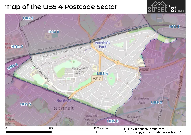
The UB5 4 Postcode shares a border with UB5 5 (NORTHOLT ), HA4 0 (RUISLIP ), UB5 6 (NORTHOLT , RUISLIP , HAYES ), UB6 0 (GREENFORD ), HA1 3 (HARROW ) and HA2 8 (HARROW , SOUTH HARROW ).
The sector is within the post town of NORTHOLT.
UB5 4 is a postcode sector within the UB5 postcode district which is within the UB Uxbridge postcode area.
The Royal Mail delivery office for the UB5 4 postal sector is the Northolt Delivery Office.
The area of the UB5 4 postcode sector is 0.85 square miles which is 2.20 square kilometres or 544.44 square acres.

Map of the UB5 4 Postcode Sector
Explore the UB5 4 postcode sector by using our free interactive map.
| U | B | 5 | - | 4 | X | X |
| U | B | 5 | Space | 4 | Letter | Letter |
Official List of Streets
NORTHOLT (94 Streets)
Unofficial Streets or Alternative Spellings
GREENFORD
BANNISTER CLOSE CURREY ROAD LILIAN BOARD WAY MARY PETERS DRIVE ROTHESAY AVENUE WADHAM GARDENSNORTHOLT
CARLTON CLOSEGREENFORD,
WHITTON AVENUE WESTSouth Harrow
NORTHOLT ROADHARROW
ALEXANDRA AVENUE WOOD END AVENUE WOOD END ROAD CARTMEL COURT FLORISTON COURT MORTON COURT NEW COURT SHERIDAN TERRACEWeather Forecast for UB5 4
Press Button to Show Forecast for Harrow
| Time Period | Icon | Description | Temperature | Rain Probability | Wind |
|---|---|---|---|---|---|
| 09:00 to 12:00 | Sunny day | 8.0°C (feels like 7.0°C) | 0.00% | N 7 mph | |
| 12:00 to 15:00 | Partly cloudy (day) | 11.0°C (feels like 10.0°C) | 0.00% | WNW 4 mph | |
| 15:00 to 18:00 | Cloudy | 13.0°C (feels like 11.0°C) | 4.00% | W 9 mph | |
| 18:00 to 21:00 | Cloudy | 12.0°C (feels like 9.0°C) | 7.00% | W 11 mph | |
| 21:00 to 00:00 | Overcast | 10.0°C (feels like 7.0°C) | 14.00% | WSW 11 mph |
Press Button to Show Forecast for Harrow
| Time Period | Icon | Description | Temperature | Rain Probability | Wind |
|---|---|---|---|---|---|
| 00:00 to 03:00 | Cloudy | 9.0°C (feels like 6.0°C) | 16.00% | WSW 11 mph | |
| 03:00 to 06:00 | Overcast | 9.0°C (feels like 6.0°C) | 13.00% | W 11 mph | |
| 06:00 to 09:00 | Overcast | 9.0°C (feels like 7.0°C) | 9.00% | WNW 11 mph | |
| 09:00 to 12:00 | Cloudy | 11.0°C (feels like 8.0°C) | 5.00% | NW 16 mph | |
| 12:00 to 15:00 | Cloudy | 12.0°C (feels like 9.0°C) | 8.00% | NW 16 mph | |
| 15:00 to 18:00 | Cloudy | 12.0°C (feels like 9.0°C) | 15.00% | NNW 13 mph | |
| 18:00 to 21:00 | Cloudy | 11.0°C (feels like 9.0°C) | 6.00% | N 11 mph | |
| 21:00 to 00:00 | Partly cloudy (night) | 8.0°C (feels like 7.0°C) | 10.00% | NNE 7 mph |
Press Button to Show Forecast for Harrow
| Time Period | Icon | Description | Temperature | Rain Probability | Wind |
|---|---|---|---|---|---|
| 00:00 to 03:00 | Partly cloudy (night) | 7.0°C (feels like 4.0°C) | 2.00% | N 9 mph | |
| 03:00 to 06:00 | Partly cloudy (night) | 5.0°C (feels like 2.0°C) | 1.00% | NNW 9 mph | |
| 06:00 to 09:00 | Cloudy | 5.0°C (feels like 2.0°C) | 4.00% | NNW 9 mph | |
| 09:00 to 12:00 | Cloudy | 8.0°C (feels like 5.0°C) | 4.00% | N 11 mph | |
| 12:00 to 15:00 | Overcast | 10.0°C (feels like 8.0°C) | 7.00% | N 9 mph | |
| 15:00 to 18:00 | Overcast | 11.0°C (feels like 9.0°C) | 7.00% | N 9 mph | |
| 18:00 to 21:00 | Cloudy | 10.0°C (feels like 8.0°C) | 4.00% | NNE 9 mph | |
| 21:00 to 00:00 | Partly cloudy (night) | 7.0°C (feels like 6.0°C) | 1.00% | NNE 7 mph |
Press Button to Show Forecast for Harrow
| Time Period | Icon | Description | Temperature | Rain Probability | Wind |
|---|---|---|---|---|---|
| 00:00 to 03:00 | Partly cloudy (night) | 6.0°C (feels like 4.0°C) | 1.00% | N 4 mph | |
| 03:00 to 06:00 | Partly cloudy (night) | 5.0°C (feels like 4.0°C) | 1.00% | N 4 mph | |
| 06:00 to 09:00 | Cloudy | 5.0°C (feels like 4.0°C) | 4.00% | NNW 4 mph | |
| 09:00 to 12:00 | Cloudy | 8.0°C (feels like 7.0°C) | 5.00% | NNE 7 mph | |
| 12:00 to 15:00 | Overcast | 11.0°C (feels like 9.0°C) | 10.00% | NNE 9 mph | |
| 15:00 to 18:00 | Overcast | 12.0°C (feels like 10.0°C) | 12.00% | NNE 9 mph | |
| 18:00 to 21:00 | Cloudy | 11.0°C (feels like 10.0°C) | 7.00% | NE 9 mph | |
| 21:00 to 00:00 | Cloudy | 9.0°C (feels like 7.0°C) | 12.00% | NE 7 mph |
Schools and Places of Education Within the UB5 4 Postcode Sector
Greenwood Primary School
Community school
Wood End Way, Northolt, , UB5 4QG
Head: Mrs Karen Silvester
Ofsted Rating: Good
Inspection: 2022-10-19 (547 days ago)
Website: Visit Greenwood Primary School Website
Phone: 02084229630
Number of Pupils: 638
Northolt High School
Foundation school
Eastcote Lane, Northolt, Middlesex, UB5 4HP
Head: Ms Marion Budd
Ofsted Rating: Good
Inspection: 2019-05-21 (1794 days ago)
Website: Visit Northolt High School Website
Phone: 02088648544
Number of Pupils: 924
Petts Hill Primary School
Community school
Newmarket Avenue, Northolt, , UB5 4HB
Head: Mrs Katherine Flewitt
Ofsted Rating: Good
Inspection: 2023-03-29 (386 days ago)
Website: Visit Petts Hill Primary School Website
Phone: 02084224095
Number of Pupils: 255
Wood End Primary School
Academy converter
Whitton Avenue West, Northolt, Middlesex, UB5 4LB
Head: Mr Warner Stainbank
Ofsted Rating: Good
Inspection: 2020-01-16 (1554 days ago)
Website: Visit Wood End Primary School Website
Phone: 02084226175
Number of Pupils: 416
House Prices in the UB5 4 Postcode Sector
| Type of Property | 2018 Average | 2018 Sales | 2017 Average | 2017 Sales | 2016 Average | 2016 Sales | 2015 Average | 2015 Sales |
|---|---|---|---|---|---|---|---|---|
| Detached | £650,000 | 1 | £700,000 | 1 | £452,500 | 3 | £0 | 0 |
| Semi-Detached | £456,694 | 51 | £454,810 | 42 | £422,041 | 33 | £388,449 | 52 |
| Terraced | £408,082 | 54 | £423,242 | 73 | £397,137 | 61 | £337,915 | 96 |
| Flats | £286,865 | 37 | £267,309 | 40 | £267,086 | 46 | £227,053 | 44 |
Important Postcodes UB5 4 in the Postcode Sector
UB5 4AB is the postcode for Northolt Leisure Centre, Eastcote Lane North
UB5 4HB is the postcode for Petts Hill Primary School, Newmarket Avenue
UB5 4HP is the postcode for SOUTH SITE, Northolt High School, Eastcote Lane, Sports Hall, Northolt High School, Eastcote Lane, and NORTH SITE, Northolt High School, Eastcote Lane
UB5 4JT is the postcode for Fire Station, 74 Petts Hill
UB5 4LB is the postcode for Wood End Infant School, Whitton Avenue West
UB5 4QG is the postcode for Greenwood Primary School, Wood End Way, JUNIOR BUILDING, Greenwood Primary School, Wood End Way, and INFANT BUILDING, Greenwood Primary School, Wood End Way
UB5 4RE is the postcode for Belvue College at Ken Acock, Carr Road
| The UB5 4 Sector is within these Local Authorities |
|
|---|---|
| The UB5 4 Sector is within these Counties |
|
| The UB5 4 Sector is within these Water Company Areas |
|