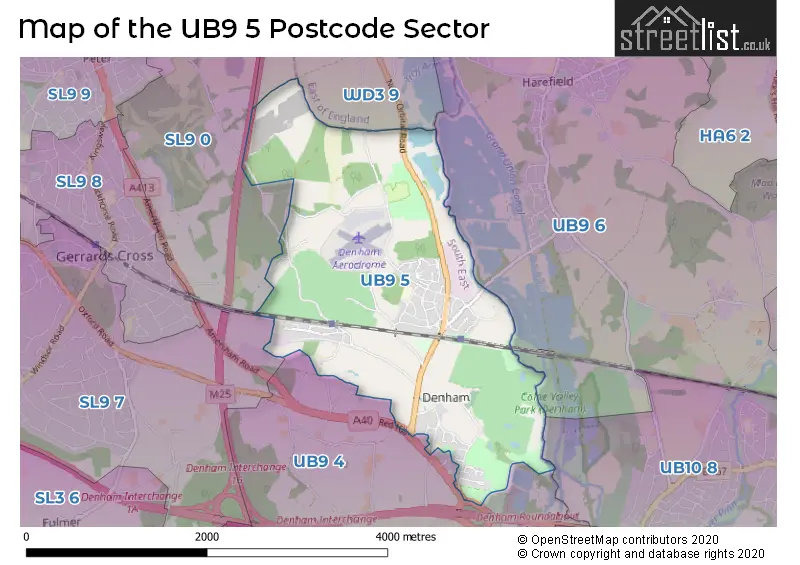
The UB9 5 postcode sector lies where the three counties of Buckinghamshire, Greater London, and Hertfordshire meet.
Did you know? According to the 2021 Census, the UB9 5 postcode sector is home to a bustling 5,364 residents!
Given that each sector allows for 400 unique postcode combinations. Letters C, I, K, M, O and V are not allowed in the last two letters of a postcode. With 154 postcodes already in use, this leaves 246 units available.
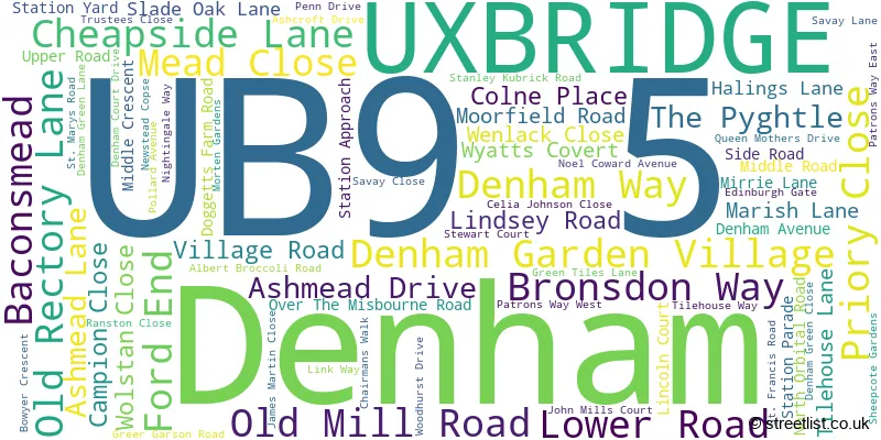
The largest settlement in the UB9 5 postal code is DENHAM followed by DENHAM GREEN , and DENHAM GARDEN VILLAGE .
The UB9 5 Postcode shares a border with SL9 0 (CHALFONT ST PETER, Chalfont St. Peter, GERRARDS CROSS), SL9 7 (GERRARDS CROSS, DENHAM, FULMER), UB9 4 (NEW DENHAM , DENHAM ), UB9 6 (HAREFIELD ), UB10 8 (ICKENHAM ) and WD3 9 (MAPLE CROSS , WEST HYDE ).
The sector is within the post town of UXBRIDGE.
UB9 5 is a postcode sector within the UB9 postcode district which is within the UB Uxbridge postcode area.
The Royal Mail delivery office for the UB9 5 postal sector is the Uxbridge Delivery Office.
The area of the UB9 5 postcode sector is 3.17 square miles which is 8.20 square kilometres or 2,026.46 square acres.
The UB9 5 postcode sector is crossed by the M25 motorway.
The UB9 5 postcode sector is crossed by the A40 Major A road.
Waterways within the UB9 5 postcode sector include the River Colne, River Missbourne.

Map of the UB9 5 Postcode Sector
Explore the UB9 5 postcode sector by using our free interactive map.
| U | B | 9 | - | 5 | X | X |
| U | B | 9 | Space | 5 | Letter | Letter |
Official List of Streets
Denham (63 Streets)
Denham Garden Village (9 Streets)
UXBRIDGE (1 Streets)
Unofficial Streets or Alternative Spellings
Weather Forecast for UB9 5
Press Button to Show Forecast for Gerrards Cross
| Time Period | Icon | Description | Temperature | Rain Probability | Wind |
|---|---|---|---|---|---|
| 06:00 to 09:00 | Cloudy | 5.0°C (feels like 4.0°C) | 4.00% | WSW 4 mph | |
| 09:00 to 12:00 | Cloudy | 9.0°C (feels like 7.0°C) | 6.00% | W 7 mph | |
| 12:00 to 15:00 | Cloudy | 10.0°C (feels like 8.0°C) | 48.00% | W 11 mph | |
| 15:00 to 18:00 | Overcast | 10.0°C (feels like 8.0°C) | 35.00% | WNW 7 mph | |
| 18:00 to 21:00 | Cloudy | 8.0°C (feels like 7.0°C) | 30.00% | NNE 4 mph | |
| 21:00 to 00:00 | Cloudy | 7.0°C (feels like 5.0°C) | 7.00% | NE 7 mph |
Press Button to Show Forecast for Gerrards Cross
| Time Period | Icon | Description | Temperature | Rain Probability | Wind |
|---|---|---|---|---|---|
| 00:00 to 03:00 | Cloudy | 6.0°C (feels like 4.0°C) | 5.00% | NE 7 mph | |
| 03:00 to 06:00 | Cloudy | 5.0°C (feels like 2.0°C) | 5.00% | NE 7 mph | |
| 06:00 to 09:00 | Cloudy | 4.0°C (feels like 2.0°C) | 5.00% | NE 7 mph | |
| 09:00 to 12:00 | Cloudy | 7.0°C (feels like 5.0°C) | 5.00% | ENE 7 mph | |
| 12:00 to 15:00 | Cloudy | 10.0°C (feels like 9.0°C) | 10.00% | ENE 7 mph | |
| 15:00 to 18:00 | Overcast | 11.0°C (feels like 10.0°C) | 14.00% | ENE 4 mph | |
| 18:00 to 21:00 | Cloudy | 10.0°C (feels like 9.0°C) | 13.00% | NE 4 mph | |
| 21:00 to 00:00 | Cloudy | 7.0°C (feels like 5.0°C) | 12.00% | ENE 7 mph |
Press Button to Show Forecast for Gerrards Cross
| Time Period | Icon | Description | Temperature | Rain Probability | Wind |
|---|---|---|---|---|---|
| 00:00 to 03:00 | Cloudy | 5.0°C (feels like 3.0°C) | 11.00% | ENE 7 mph | |
| 03:00 to 06:00 | Cloudy | 5.0°C (feels like 2.0°C) | 18.00% | NE 7 mph | |
| 06:00 to 09:00 | Cloudy | 5.0°C (feels like 3.0°C) | 22.00% | NE 7 mph | |
| 09:00 to 12:00 | Cloudy | 9.0°C (feels like 6.0°C) | 17.00% | ENE 9 mph | |
| 12:00 to 15:00 | Overcast | 11.0°C (feels like 9.0°C) | 18.00% | E 9 mph | |
| 15:00 to 18:00 | Overcast | 12.0°C (feels like 10.0°C) | 25.00% | E 11 mph | |
| 18:00 to 21:00 | Light rain | 11.0°C (feels like 9.0°C) | 53.00% | ENE 9 mph | |
| 21:00 to 00:00 | Light rain | 9.0°C (feels like 6.0°C) | 53.00% | NE 11 mph |
Press Button to Show Forecast for Gerrards Cross
| Time Period | Icon | Description | Temperature | Rain Probability | Wind |
|---|---|---|---|---|---|
| 00:00 to 03:00 | Heavy rain | 8.0°C (feels like 6.0°C) | 75.00% | NE 11 mph | |
| 03:00 to 06:00 | Heavy rain | 8.0°C (feels like 7.0°C) | 77.00% | ENE 7 mph | |
| 06:00 to 09:00 | Light rain | 9.0°C (feels like 7.0°C) | 54.00% | ESE 7 mph | |
| 09:00 to 12:00 | Heavy rain | 10.0°C (feels like 8.0°C) | 75.00% | ESE 9 mph | |
| 12:00 to 15:00 | Light rain | 12.0°C (feels like 10.0°C) | 51.00% | SSE 9 mph | |
| 15:00 to 18:00 | Heavy rain shower (day) | 13.0°C (feels like 11.0°C) | 60.00% | SSW 11 mph | |
| 18:00 to 21:00 | Light rain shower (day) | 11.0°C (feels like 9.0°C) | 36.00% | WSW 11 mph | |
| 21:00 to 00:00 | Cloudy | 9.0°C (feels like 8.0°C) | 8.00% | SW 7 mph |
Schools and Places of Education Within the UB9 5 Postcode Sector
Denham Green E-ACT Primary Academy
Academy sponsor led
Nightingale Way, Denham Green, Buckinghamshire, UB9 5JL
Head: Mrs Claire Kilyan
Ofsted Rating: Good
Inspection: 2022-10-05 (568 days ago)
Website: Visit Denham Green E-ACT Primary Academy Website
Phone: 01895833369
Number of Pupils: 230
Denham Village School
Community school
Cheapside Lane, Uxbridge, Buckinghamshire, UB9 5AE
Head: Mrs Seema Sharma
Ofsted Rating: Good
Inspection: 2018-10-11 (2023 days ago)
Website: Visit Denham Village School Website
Phone: 01895832768
Number of Pupils: 78
House Prices in the UB9 5 Postcode Sector
| Type of Property | 2018 Average | 2018 Sales | 2017 Average | 2017 Sales | 2016 Average | 2016 Sales | 2015 Average | 2015 Sales |
|---|---|---|---|---|---|---|---|---|
| Detached | £948,056 | 18 | £916,860 | 25 | £788,685 | 27 | £780,628 | 29 |
| Semi-Detached | £521,354 | 12 | £496,929 | 14 | £494,740 | 10 | £492,385 | 13 |
| Terraced | £387,382 | 11 | £433,071 | 14 | £483,695 | 10 | £396,455 | 11 |
| Flats | £384,528 | 60 | £355,708 | 87 | £306,694 | 37 | £306,315 | 27 |
Important Postcodes UB9 5 in the Postcode Sector
UB9 5AE is the postcode for Denham County Infant School, Cheapside Lane
UB9 5GA is the postcode for Denham Medical Centre, Queen Mothers Drive
UB9 5JL is the postcode for Denham Green E A C T Primary Academy, Nightingale Way, and Denham Green E-Act Primary Academy, Nightingale Way
| The UB9 5 Sector is within these Local Authorities |
|
|---|---|
| The UB9 5 Sector is within these Counties |
|
| The UB9 5 Sector is within these Water Company Areas |
|