The WA11 7 postcode sector stands on the Merseyside and Lancashire border.
Did you know? According to the 2021 Census, the WA11 7 postcode sector is home to a bustling 6,843 residents!
Given that each sector allows for 400 unique postcode combinations. Letters C, I, K, M, O and V are not allowed in the last two letters of a postcode. With 216 postcodes already in use, this leaves 184 units available.
The largest settlement in the WA11 7 postal code is ST. HELENS followed by Rainford, and Crank.
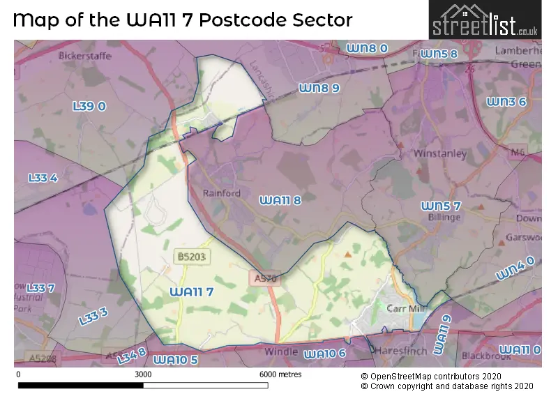
The WA11 7 Postcode shares a border with WN8 9 (SKELMERSDALE, Crawford Village, Upholland), WA10 6 (ST. HELENS, Dentons Green, Windle), WA11 8 (Rainford, ST. HELENS, Crank), WA11 9 (ST. HELENS, Haydock), WA10 5 (Eccleston, ST. HELENS), WN4 0 (Ashton-in-Makerfield), WN5 7 (Billinge, Orrell), L33 3 (LIVERPOOL, Kirkby, Knowsley Industrial Park) and L39 0 (Bickerstaffe).
The sector is within the post town of ST. HELENS.
WA11 7 is a postcode sector within the WA11 postcode district which is within the WA Warrington postcode area.
The Royal Mail delivery office for the WA11 7 postal sector is the St Helens Delivery Office.
The area of the WA11 7 postcode sector is 8.63 square miles which is 22.35 square kilometres or 5,521.60 square acres.
Waterways within the WA11 7 postcode sector include the Black Brook, Rainford Brook.

Map of the WA11 7 Postcode Sector
Explore the WA11 7 postcode sector by using our free interactive map.
| W | A | 1 | 1 | - | 7 | X | X |
| W | A | 1 | 1 | Space | 7 | Letter | Letter |
Official List of Streets
ST. HELENS (71 Streets)
Crank (7 Streets)
Rainford (27 Streets)
Unofficial Streets or Alternative Spellings
ST. HELENS
CITY ROAD WASHWAY LANE BIRCHLEY VIEW BLIND FOOT ROAD CHERRY TREE LANE HILLTOP ROAD HOLLY FOLD LANE NEW CUT LANE RAINFORD BY-PASS RAINFORD LINEAR PARK SCAFELL ROAD THE ARCHESRainford
LORDS FOLD TUDOR CLOSEBickerstaffe
COACH ROAD HOLLY LANE LODGE LANE RAINFORD ROADGlazebury
EAST LANCASHIRE ROADAshton-in-Makerfield
GARSWOOD OLD ROADDentons Green
ABBEY ROAD RAINFORD ROADCrank
RED CAT LANEBillinge
CARR MILL ROADSchools and Places of Education Within the WA11 7 Postcode Sector
Carr Mill Primary School
Community school
Kentmere Avenue, St Helens, Merseyside, WA11 7PQ
Head: Mr Andrew Maley
Ofsted Rating: Good
Inspection: 2023-03-02 (421 days ago)
Website: Visit Carr Mill Primary School Website
Phone: 01744678223
Number of Pupils: 311
House Prices in the WA11 7 Postcode Sector
| Type of Property | 2018 Average | 2018 Sales | 2017 Average | 2017 Sales | 2016 Average | 2016 Sales | 2015 Average | 2015 Sales |
|---|---|---|---|---|---|---|---|---|
| Detached | £298,721 | 17 | £273,000 | 8 | £271,961 | 14 | £324,988 | 8 |
| Semi-Detached | £165,756 | 53 | £156,298 | 51 | £127,127 | 45 | £135,657 | 47 |
| Terraced | £110,967 | 15 | £103,895 | 19 | £92,033 | 15 | £87,559 | 22 |
| Flats | £42,000 | 1 | £42,500 | 1 | £0 | 0 | £0 | 0 |
Important Postcodes WA11 7 in the Postcode Sector
WA11 7BU is the postcode for Moss Bank Elderly Persons Home, Victoria Avenue
WA11 7PQ is the postcode for Carr Mill Primary School, Kentmere Avenue
WA11 7RS is the postcode for Fairfield Hospital, Crank Road, and FAIRFIELD HOSPITAL, CRANK ROAD, CRANK
| The WA11 7 Sector is within these Local Authorities |
|
|---|---|
| The WA11 7 Sector is within these Counties |
|
| The WA11 7 Sector is within these Water Company Areas |
|