The WA15 7 postcode sector is within the county of Greater Manchester.
Did you know? According to the 2021 Census, the WA15 7 postcode sector is home to a bustling 11,318 residents!
Given that each sector allows for 400 unique postcode combinations. Letters C, I, K, M, O and V are not allowed in the last two letters of a postcode. With 281 postcodes already in use, this leaves 119 units available.
The WA15 7 postal code covers the settlement of Timperley.
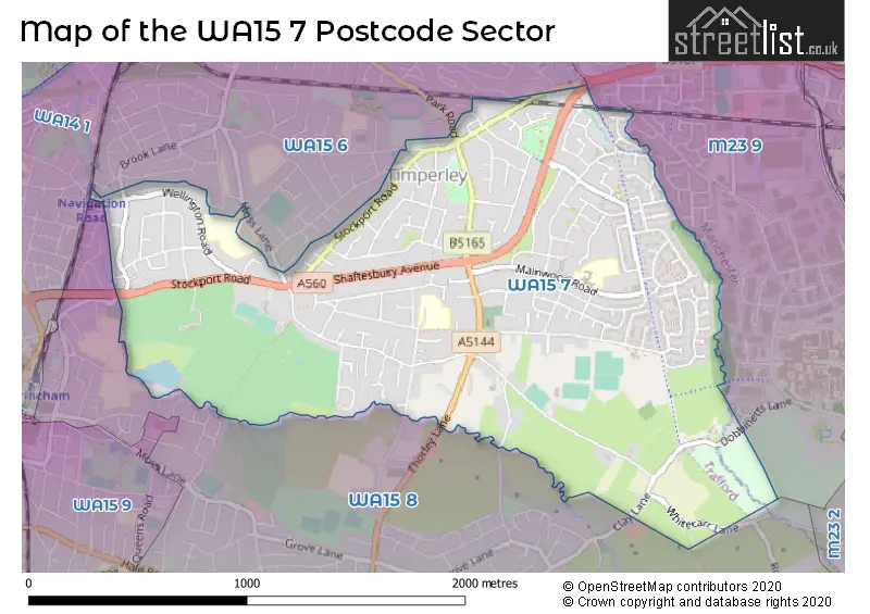
The WA15 7 Postcode shares a border with WA14 1 (ALTRINCHAM, Timperley), WA15 6 (Timperley), M23 9 (MANCHESTER, Roundthorn Industrial Estate, Wythenshawe) and WA15 8 (Hale, ALTRINCHAM, Hale Barns).
The sector is within the post town of ALTRINCHAM.
WA15 7 is a postcode sector within the WA15 postcode district which is within the WA Warrington postcode area.
The Royal Mail delivery office for the WA15 7 postal sector is the Altrincham Delivery Office.
The area of the WA15 7 postcode sector is 1.37 square miles which is 3.56 square kilometres or 879.14 square acres.

Map of the WA15 7 Postcode Sector
Explore the WA15 7 postcode sector by using our free interactive map.
| W | A | 1 | 5 | - | 7 | X | X |
| W | A | 1 | 5 | Space | 7 | Letter | Letter |
Official List of Streets
Timperley (153 Streets)
Unofficial Streets or Alternative Spellings
Weather Forecast for WA15 7
Press Button to Show Forecast for Timperley
| Time Period | Icon | Description | Temperature | Rain Probability | Wind |
|---|---|---|---|---|---|
| 00:00 to 03:00 | Clear night | 4.0°C (feels like 3.0°C) | 0.00% | E 2 mph | |
| 03:00 to 06:00 | Clear night | 3.0°C (feels like 2.0°C) | 0.00% | NNW 2 mph | |
| 06:00 to 09:00 | Sunny day | 4.0°C (feels like 3.0°C) | 0.00% | NNW 4 mph | |
| 09:00 to 12:00 | Sunny day | 8.0°C (feels like 7.0°C) | 0.00% | NNW 4 mph | |
| 12:00 to 15:00 | Cloudy | 11.0°C (feels like 10.0°C) | 5.00% | NNW 7 mph | |
| 15:00 to 18:00 | Cloudy | 12.0°C (feels like 10.0°C) | 5.00% | NNW 7 mph | |
| 18:00 to 21:00 | Cloudy | 11.0°C (feels like 9.0°C) | 5.00% | NNW 7 mph | |
| 21:00 to 00:00 | Cloudy | 8.0°C (feels like 7.0°C) | 4.00% | NNW 4 mph |
Press Button to Show Forecast for Timperley
| Time Period | Icon | Description | Temperature | Rain Probability | Wind |
|---|---|---|---|---|---|
| 00:00 to 03:00 | Cloudy | 6.0°C (feels like 5.0°C) | 4.00% | NNE 4 mph | |
| 03:00 to 06:00 | Overcast | 6.0°C (feels like 5.0°C) | 9.00% | E 2 mph | |
| 06:00 to 09:00 | Light rain | 6.0°C (feels like 5.0°C) | 46.00% | ENE 4 mph | |
| 09:00 to 12:00 | Cloudy | 8.0°C (feels like 6.0°C) | 15.00% | E 4 mph | |
| 12:00 to 15:00 | Cloudy | 10.0°C (feels like 9.0°C) | 14.00% | ENE 7 mph | |
| 15:00 to 18:00 | Cloudy | 12.0°C (feels like 10.0°C) | 7.00% | NE 7 mph | |
| 18:00 to 21:00 | Cloudy | 11.0°C (feels like 9.0°C) | 6.00% | NE 7 mph | |
| 21:00 to 00:00 | Cloudy | 7.0°C (feels like 6.0°C) | 8.00% | NE 4 mph |
Press Button to Show Forecast for Timperley
| Time Period | Icon | Description | Temperature | Rain Probability | Wind |
|---|---|---|---|---|---|
| 00:00 to 03:00 | Overcast | 7.0°C (feels like 6.0°C) | 10.00% | E 4 mph | |
| 03:00 to 06:00 | Overcast | 6.0°C (feels like 5.0°C) | 12.00% | SSE 2 mph | |
| 06:00 to 09:00 | Cloudy | 6.0°C (feels like 5.0°C) | 13.00% | S 4 mph | |
| 09:00 to 12:00 | Cloudy | 9.0°C (feels like 7.0°C) | 12.00% | SW 7 mph | |
| 12:00 to 15:00 | Overcast | 11.0°C (feels like 9.0°C) | 16.00% | NE 9 mph | |
| 15:00 to 18:00 | Cloudy | 11.0°C (feels like 9.0°C) | 14.00% | NNE 9 mph | |
| 18:00 to 21:00 | Cloudy | 11.0°C (feels like 10.0°C) | 12.00% | N 7 mph | |
| 21:00 to 00:00 | Cloudy | 9.0°C (feels like 8.0°C) | 10.00% | N 4 mph |
Press Button to Show Forecast for Timperley
| Time Period | Icon | Description | Temperature | Rain Probability | Wind |
|---|---|---|---|---|---|
| 00:00 to 03:00 | Overcast | 8.0°C (feels like 6.0°C) | 11.00% | NE 7 mph | |
| 03:00 to 06:00 | Overcast | 6.0°C (feels like 4.0°C) | 10.00% | ENE 7 mph | |
| 06:00 to 09:00 | Cloudy | 6.0°C (feels like 4.0°C) | 8.00% | NE 7 mph | |
| 09:00 to 12:00 | Cloudy | 9.0°C (feels like 7.0°C) | 7.00% | NE 9 mph | |
| 12:00 to 15:00 | Overcast | 11.0°C (feels like 9.0°C) | 9.00% | NNE 9 mph | |
| 15:00 to 18:00 | Overcast | 12.0°C (feels like 10.0°C) | 9.00% | NNE 9 mph | |
| 18:00 to 21:00 | Cloudy | 11.0°C (feels like 10.0°C) | 7.00% | NNE 7 mph | |
| 21:00 to 00:00 | Clear night | 7.0°C (feels like 5.0°C) | 3.00% | NE 7 mph |
Schools and Places of Education Within the WA15 7 Postcode Sector
Broomwood Primary School
Community school
Mainwood Road, Altrincham, Cheshire, WA15 7JU
Head: Dr Louise Owen
Ofsted Rating: Good
Inspection: 2019-03-06 (1872 days ago)
Website: Visit Broomwood Primary School Website
Phone: 01619125609
Number of Pupils: 460
Cloverlea Primary School
Community school
Green Lane North, Altrincham, Cheshire, WA15 7NQ
Head: Mr C McConnell
Ofsted Rating: Requires improvement
Inspection: 2022-06-22 (668 days ago)
Website: Visit Cloverlea Primary School Website
Phone: 01619808338
Number of Pupils: 235
Wellington School
Academy converter
Wellington Road, Altrincham, Cheshire, WA15 7RH
Head: Stuart Beeley
Ofsted Rating: Good
Inspection: 2022-05-12 (709 days ago)
Website: Visit Wellington School Website
Phone: 01619284157
Number of Pupils: 1498
House Prices in the WA15 7 Postcode Sector
| Type of Property | 2018 Average | 2018 Sales | 2017 Average | 2017 Sales | 2016 Average | 2016 Sales | 2015 Average | 2015 Sales |
|---|---|---|---|---|---|---|---|---|
| Detached | £490,602 | 49 | £453,768 | 46 | £442,889 | 36 | £376,078 | 48 |
| Semi-Detached | £359,708 | 57 | £328,624 | 77 | £333,447 | 62 | £270,506 | 80 |
| Terraced | £237,012 | 24 | £220,466 | 25 | £192,764 | 30 | £197,735 | 34 |
| Flats | £180,413 | 44 | £195,171 | 39 | £204,488 | 74 | £147,952 | 41 |
Important Postcodes WA15 7 in the Postcode Sector
WA15 7JU is the postcode for Broomwood Cp School, Mainwood Road, and Broomwood Primary School, Mainwood Road, Timperley
WA15 7JW is the postcode for The Lakes Medical Centre, 53c Mainwood Road
WA15 7NQ is the postcode for Cloverlea Primary School, Green Lane North
WA15 7RH is the postcode for KITCHEN / SPORTS HALL, Wellington School, Wellington Road, GLOUCESTER / MOSS BUILDING, Wellington School, Wellington Road, LYNTON BUILDING, Wellington School, Wellington Road, and VALE BUILDING, Wellington School, Wellington Road
| The WA15 7 Sector is within these Local Authorities |
|
|---|---|
| The WA15 7 Sector is within these Counties |
|
| The WA15 7 Sector is within these Water Company Areas |
|