The WA4 4 postcode sector is within the county of Cheshire.
Did you know? According to the 2021 Census, the WA4 4 postcode sector is home to a bustling 3,696 residents!
Given that each sector allows for 400 unique postcode combinations. Letters C, I, K, M, O and V are not allowed in the last two letters of a postcode. With 225 postcodes already in use, this leaves 175 units available.
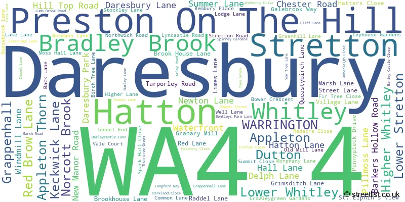
The largest settlement in the WA4 4 postal code is Appleton Thorn followed by Daresbury, and Dutton.
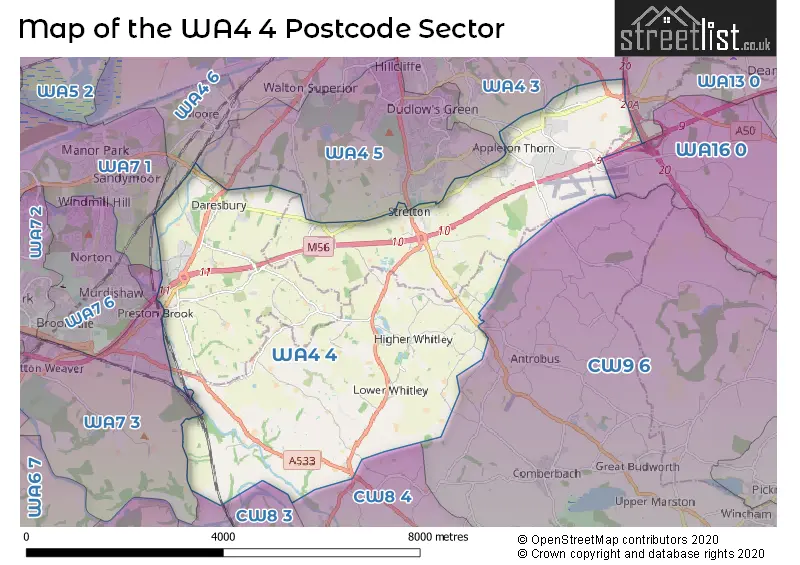
The WA4 4 Postcode shares a border with WA7 1 (RUNCORN, Astmoor Industrial Estate, Manor Park), WA13 0 (LYMM), CW8 2 (Cuddington, Sandiway, Oakmere), CW8 3 (Weaverham, Acton Bridge, Hartford), CW8 4 (NORTHWICH, Barnton, Winnington), CW9 6 (Wincham, Antrobus, Comberbach), WA4 3 (Appleton, Grappenhall, WARRINGTON), WA4 5 (Appleton, Hatton, Higher Walton), WA4 6 (WARRINGTON, Stockton Heath, Moore), WA7 3 (Beechwood, Sutton Weaver, Preston Brook) and WA16 0 (KNUTSFORD, Pickmere, High Legh).
The sector is within the post town of WARRINGTON.
WA4 4 is a postcode sector within the WA4 postcode district which is within the WA Warrington postcode area.
The Royal Mail delivery office for the WA4 4 postal sector is the Warrington Delivery Office.
The area of the WA4 4 postcode sector is 16.03 square miles which is 41.52 square kilometres or 10,260.60 square acres.
The WA4 4 postcode sector is crossed by the M56 motorway.
The WA4 4 postcode sector is crossed by the M6 motorway.
Waterways within the WA4 4 postcode sector include the Trent and Mersey Canal, Bridgewater Canal - Runcorn Branch, Bridgewater Canal.

Map of the WA4 4 Postcode Sector
Explore the WA4 4 postcode sector by using our free interactive map.
| W | A | 4 | - | 4 | X | X |
| W | A | 4 | Space | 4 | Letter | Letter |
Official List of Streets
Appleton Thorn (16 Streets)
Appleton (7 Streets)
Higher Whitley (15 Streets)
Dutton (9 Streets)
Preston On The Hill (9 Streets)
Stretton (6 Streets)
Lower Whitley (11 Streets)
Grappenhall (2 Streets)
Daresbury (13 Streets)
Lower Stretton (7 Streets)
Hatton (5 Streets)
Whitley (2 Streets)
Bradley Brook (1 Streets)
Norcott Brook (1 Streets)
Unofficial Streets or Alternative Spellings
Grappenhall
BROAD LANE KNUTSFORD ROADHigh Legh
SWINEYARD LANEAppleton
LONDON ROAD SWINLEY FOREST DRIVE WALNUT TREE LANEAppleton Thorn
GREEN LANE LUMB BROOK ROAD BARKERS HOLLOW LANE BLACKCAP ROAD BOOTHS LANE BRINDLEY WHARF BROAD LANE ROUNDABOUT BROOK FARM LANE CINNABAR COURT CLIFF LANE ROUNDABOUT DARESBURY EXPRESSWAY DARESBURY PARK ROUNDABOUT DUTTON WHARF BRIDGE FOGGS LANE GREENHILL COMMON LANE HEATH LANE INNER GOSLING CLOSE INNOVATION WAY LYMM INTERCHANGE LYNCASTLE WAY MOSSHALL LANE NEW LANE NEWTON BANK OLD TARPORLEY ROAD OWENS WALK PRESTON BROOK INTERCHANGE SANKEY LANE STRETTON ROAD ISLAND STRETTON ROUNDABOUT THE BRACKENS TUNNEL TOP NORTH TUNNEL TOP SOUTH VILLAGE FARMBarnton
RUNCORN ROADActon Bridge
WARRINGTON ROADHatton
WARRINGTON ROADPreston Brook
THE WHARFAntrobus
GOOSEBROOK LANE NORTHWICH ROAD WELL LANEWeather Forecast for WA4 4
Press Button to Show Forecast for Walton Hall Gardens
| Time Period | Icon | Description | Temperature | Rain Probability | Wind |
|---|---|---|---|---|---|
| 00:00 to 03:00 | Clear night | 6.0°C (feels like 4.0°C) | 1.00% | E 4 mph | |
| 03:00 to 06:00 | Clear night | 5.0°C (feels like 4.0°C) | 0.00% | SSW 2 mph | |
| 06:00 to 09:00 | Partly cloudy (day) | 5.0°C (feels like 4.0°C) | 0.00% | SSE 2 mph | |
| 09:00 to 12:00 | Sunny day | 8.0°C (feels like 7.0°C) | 0.00% | NNW 2 mph | |
| 12:00 to 15:00 | Cloudy | 10.0°C (feels like 9.0°C) | 4.00% | NNW 7 mph | |
| 15:00 to 18:00 | Overcast | 11.0°C (feels like 10.0°C) | 8.00% | NNW 9 mph | |
| 18:00 to 21:00 | Partly cloudy (day) | 10.0°C (feels like 9.0°C) | 1.00% | NW 7 mph | |
| 21:00 to 00:00 | Partly cloudy (night) | 8.0°C (feels like 7.0°C) | 0.00% | NNW 4 mph |
Press Button to Show Forecast for Walton Hall Gardens
| Time Period | Icon | Description | Temperature | Rain Probability | Wind |
|---|---|---|---|---|---|
| 00:00 to 03:00 | Cloudy | 6.0°C (feels like 6.0°C) | 4.00% | NNE 2 mph | |
| 03:00 to 06:00 | Overcast | 6.0°C (feels like 5.0°C) | 9.00% | E 2 mph | |
| 06:00 to 09:00 | Cloudy | 6.0°C (feels like 5.0°C) | 44.00% | E 4 mph | |
| 09:00 to 12:00 | Cloudy | 8.0°C (feels like 6.0°C) | 15.00% | ENE 7 mph | |
| 12:00 to 15:00 | Light rain | 10.0°C (feels like 8.0°C) | 50.00% | ENE 7 mph | |
| 15:00 to 18:00 | Cloudy | 12.0°C (feels like 10.0°C) | 6.00% | NE 7 mph | |
| 18:00 to 21:00 | Cloudy | 11.0°C (feels like 10.0°C) | 6.00% | NE 7 mph | |
| 21:00 to 00:00 | Cloudy | 8.0°C (feels like 6.0°C) | 7.00% | ENE 4 mph |
Press Button to Show Forecast for Walton Hall Gardens
| Time Period | Icon | Description | Temperature | Rain Probability | Wind |
|---|---|---|---|---|---|
| 00:00 to 03:00 | Overcast | 7.0°C (feels like 6.0°C) | 10.00% | ESE 4 mph | |
| 03:00 to 06:00 | Overcast | 6.0°C (feels like 5.0°C) | 13.00% | S 4 mph | |
| 06:00 to 09:00 | Overcast | 6.0°C (feels like 5.0°C) | 14.00% | S 4 mph | |
| 09:00 to 12:00 | Light rain | 9.0°C (feels like 7.0°C) | 43.00% | SW 7 mph | |
| 12:00 to 15:00 | Cloudy | 11.0°C (feels like 9.0°C) | 14.00% | SSW 9 mph | |
| 15:00 to 18:00 | Overcast | 11.0°C (feels like 9.0°C) | 17.00% | NE 9 mph | |
| 18:00 to 21:00 | Cloudy | 11.0°C (feels like 10.0°C) | 12.00% | NE 7 mph | |
| 21:00 to 00:00 | Overcast | 10.0°C (feels like 9.0°C) | 13.00% | NNE 4 mph |
Press Button to Show Forecast for Walton Hall Gardens
| Time Period | Icon | Description | Temperature | Rain Probability | Wind |
|---|---|---|---|---|---|
| 00:00 to 03:00 | Cloudy | 9.0°C (feels like 7.0°C) | 7.00% | NE 7 mph | |
| 03:00 to 06:00 | Cloudy | 7.0°C (feels like 5.0°C) | 9.00% | NE 7 mph | |
| 06:00 to 09:00 | Cloudy | 6.0°C (feels like 4.0°C) | 7.00% | NE 7 mph | |
| 09:00 to 12:00 | Cloudy | 9.0°C (feels like 7.0°C) | 5.00% | NE 9 mph | |
| 12:00 to 15:00 | Overcast | 11.0°C (feels like 9.0°C) | 9.00% | NNE 9 mph | |
| 15:00 to 18:00 | Overcast | 12.0°C (feels like 10.0°C) | 10.00% | NNE 9 mph | |
| 18:00 to 21:00 | Cloudy | 11.0°C (feels like 10.0°C) | 7.00% | NNE 7 mph | |
| 21:00 to 00:00 | Partly cloudy (night) | 9.0°C (feels like 7.0°C) | 2.00% | NE 4 mph |
Schools and Places of Education Within the WA4 4 Postcode Sector
Daresbury Primary School
Academy converter
Chester Road, Warrington, Cheshire, WA4 4AJ
Head: Mrs Kathryn Zuger
Ofsted Rating: Good
Inspection: 2023-03-02 (415 days ago)
Website: Visit Daresbury Primary School Website
Phone: 01925740309
Number of Pupils: 197
House Prices in the WA4 4 Postcode Sector
| Type of Property | 2018 Average | 2018 Sales | 2017 Average | 2017 Sales | 2016 Average | 2016 Sales | 2015 Average | 2015 Sales |
|---|---|---|---|---|---|---|---|---|
| Detached | £459,012 | 28 | £417,063 | 23 | £411,563 | 23 | £466,139 | 18 |
| Semi-Detached | £366,479 | 12 | £302,820 | 17 | £313,957 | 14 | £324,057 | 14 |
| Terraced | £277,333 | 6 | £279,373 | 12 | £269,461 | 13 | £349,745 | 10 |
| Flats | £102,500 | 2 | £0 | 0 | £200,833 | 3 | £163,494 | 5 |
Important Postcodes WA4 4 in the Postcode Sector
WA4 4AD is the postcode for RECEPTION BUILDING, Daresbury Laboratory, Keckwick Lane, BLOCK D, Daresbury Laboratory, Keckwick Lane, AMENITY BLOCK, Daresbury Laboratory, Keckwick Lane, BLOCK B, Daresbury Laboratory, Keckwick Lane, and BLOCK A, Daresbury Laboratory, Keckwick Lane
WA4 4FS is the postcode for North West Development Agency, Daresbury Innovation Centre, Keckwick Lane, and Hartree Building, Keckwick Lane
WA4 4NT is the postcode for Stretton St. Matthew's CE Primary School, Stretton Road, Stretton, St. Matthews C of E Primary School, Stretton Road, Stretton St. Matthew's CE Primary School, Stretton Road, and Stretton St Matthews C E Primary School, Stretton Road
WA4 4QH is the postcode for Whitley Village School, Village Lane
WA4 4RL is the postcode for H M Young Offenders Institute, Thorn Cross, Arley Road
WA4 4RW is the postcode for Appleton Thorn Primary School, Arley Road, Appleton, and Appleton Thorn Primary School, Arley Road
| The WA4 4 Sector is within these Local Authorities |
|
|---|---|
| The WA4 4 Sector is within these Counties |
|
| The WA4 4 Sector is within these Water Company Areas |
|