The WA5 3 postcode sector stands on the Cheshire and Merseyside border.
Did you know? According to the 2021 Census, the WA5 3 postcode sector is home to a bustling 13,354 residents!
Given that each sector allows for 400 unique postcode combinations. Letters C, I, K, M, O and V are not allowed in the last two letters of a postcode. With 262 postcodes already in use, this leaves 138 units available.
The WA5 3 postal code covers the settlement of Great Sankey.
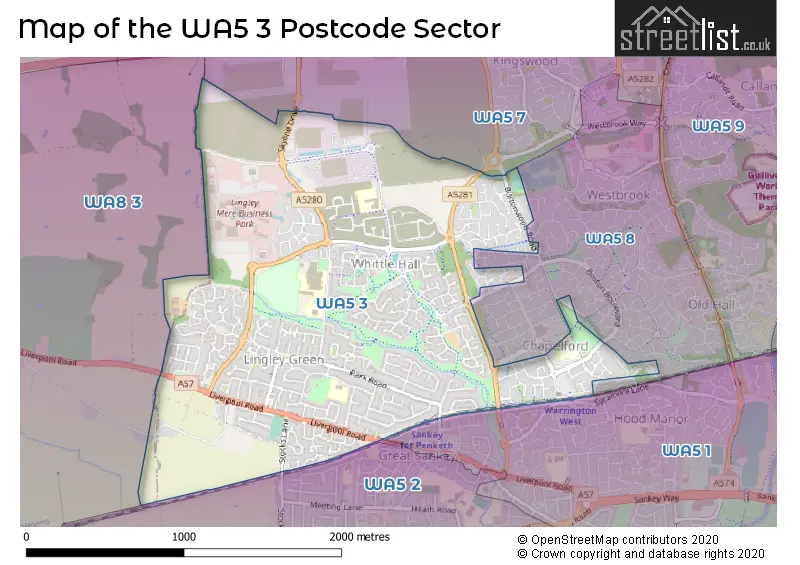
The WA5 3 Postcode shares a border with WA5 8 (Great Sankey, Old Hall, Westbrook), WA8 3 (WIDNES, Bold Heath), WA5 1 (Great Sankey, WARRINGTON), WA5 2 (Penketh, Great Sankey, Cuerdley) and WA5 7 (Westbrook).
The sector is within the post town of WARRINGTON.
WA5 3 is a postcode sector within the WA5 postcode district which is within the WA Warrington postcode area.
The Royal Mail delivery office for the WA5 3 postal sector is the Warrington Delivery Office.
The area of the WA5 3 postcode sector is 1.76 square miles which is 4.57 square kilometres or 1,128.79 square acres.

Map of the WA5 3 Postcode Sector
Explore the WA5 3 postcode sector by using our free interactive map.
| W | A | 5 | - | 3 | X | X |
| W | A | 5 | Space | 3 | Letter | Letter |
Official List of Streets
Great Sankey (203 Streets)
WARRINGTON (1 Streets)
Unofficial Streets or Alternative Spellings
Great Sankey
BRISTOW CLOSE HOUSTON GARDENS LIBERTY CLOSE MCKINLEY STREET OKLAHOMA BOULEVARD PORTLAND ROAD SAN DIEGO DRIVE ALBERT DRIVE BARROW HALL LANE ROUNDABOUT BLYTON COURT BURMA ROAD CHAPELFORD ROUNDABOUT DEEP DALE ELVINGTON COURT FENWORTHY FLIXTON COURT GLENDALE WALK INDIA GARDENS KINGSDALE ROAD KINGSDALE ROAD ROUNDABOUT LINGLEY COURT LINGLEY MERE ROUNDABOUT OAKLAHOMA BOULEVARD ODESSA WALK PARK ROAD ROUNDABOUT PHILIPS DRIVE PICKET FENCE PINEHURST WALK RAMSBURY COURT SHARPES VIEW STANHOE DRIVE SUNSET BOULEVARD THATCHED COTTAGE ROUNDABOUT WENSLEYDALE CLOSE ROUNDABOUT WHITTLE AVENUE WHITTLE BROOK GREENWAY WINDEY GRASS WAYBurtonwood
BURTONWOOD ROADWIDNES
SANDY LANEPenketh
STOCKS LANEBold Heath
WARRINGTON ROADWeather Forecast for WA5 3
Press Button to Show Forecast for Warrington
| Time Period | Icon | Description | Temperature | Rain Probability | Wind |
|---|---|---|---|---|---|
| 21:00 to 00:00 | Cloudy | 7.0°C (feels like 5.0°C) | 6.00% | ENE 7 mph |
Press Button to Show Forecast for Warrington
| Time Period | Icon | Description | Temperature | Rain Probability | Wind |
|---|---|---|---|---|---|
| 00:00 to 03:00 | Cloudy | 5.0°C (feels like 3.0°C) | 4.00% | ENE 4 mph | |
| 03:00 to 06:00 | Partly cloudy (night) | 4.0°C (feels like 2.0°C) | 1.00% | ENE 4 mph | |
| 06:00 to 09:00 | Partly cloudy (day) | 4.0°C (feels like 2.0°C) | 1.00% | ENE 4 mph | |
| 09:00 to 12:00 | Cloudy | 7.0°C (feels like 6.0°C) | 5.00% | E 4 mph | |
| 12:00 to 15:00 | Cloudy | 9.0°C (feels like 9.0°C) | 9.00% | E 4 mph | |
| 15:00 to 18:00 | Cloudy | 10.0°C (feels like 10.0°C) | 7.00% | ENE 4 mph | |
| 18:00 to 21:00 | Cloudy | 10.0°C (feels like 9.0°C) | 7.00% | NE 4 mph | |
| 21:00 to 00:00 | Partly cloudy (night) | 6.0°C (feels like 4.0°C) | 4.00% | ENE 7 mph |
Press Button to Show Forecast for Warrington
| Time Period | Icon | Description | Temperature | Rain Probability | Wind |
|---|---|---|---|---|---|
| 00:00 to 03:00 | Partly cloudy (night) | 4.0°C (feels like 3.0°C) | 5.00% | ENE 4 mph | |
| 03:00 to 06:00 | Partly cloudy (night) | 4.0°C (feels like 2.0°C) | 6.00% | ENE 4 mph | |
| 06:00 to 09:00 | Partly cloudy (day) | 5.0°C (feels like 3.0°C) | 6.00% | ENE 4 mph | |
| 09:00 to 12:00 | Partly cloudy (day) | 8.0°C (feels like 7.0°C) | 5.00% | E 7 mph | |
| 12:00 to 15:00 | Overcast | 10.0°C (feels like 9.0°C) | 16.00% | E 7 mph | |
| 15:00 to 18:00 | Cloudy | 11.0°C (feels like 9.0°C) | 18.00% | ENE 9 mph | |
| 18:00 to 21:00 | Cloudy | 10.0°C (feels like 8.0°C) | 15.00% | ENE 9 mph | |
| 21:00 to 00:00 | Cloudy | 8.0°C (feels like 5.0°C) | 17.00% | NE 9 mph |
Press Button to Show Forecast for Warrington
| Time Period | Icon | Description | Temperature | Rain Probability | Wind |
|---|---|---|---|---|---|
| 00:00 to 03:00 | Cloudy | 6.0°C (feels like 4.0°C) | 16.00% | NE 9 mph | |
| 03:00 to 06:00 | Cloudy | 6.0°C (feels like 4.0°C) | 20.00% | NNE 9 mph | |
| 06:00 to 09:00 | Cloudy | 7.0°C (feels like 4.0°C) | 22.00% | NNE 9 mph | |
| 09:00 to 12:00 | Light rain | 8.0°C (feels like 5.0°C) | 51.00% | NNE 11 mph | |
| 12:00 to 15:00 | Heavy rain | 9.0°C (feels like 7.0°C) | 77.00% | N 11 mph | |
| 15:00 to 18:00 | Light rain | 10.0°C (feels like 7.0°C) | 57.00% | N 9 mph | |
| 18:00 to 21:00 | Cloudy | 10.0°C (feels like 8.0°C) | 18.00% | N 9 mph | |
| 21:00 to 00:00 | Clear night | 8.0°C (feels like 6.0°C) | 10.00% | NW 7 mph |
Schools and Places of Education Within the WA5 3 Postcode Sector
Barrow Hall Community Primary School
Community school
Sophia Drive, Warrington, Cheshire, WA5 3TX
Head: Mr John Littler
Ofsted Rating: Outstanding
Inspection: 2023-07-19 (281 days ago)
Website: Visit Barrow Hall Community Primary School Website
Phone: 01925717633
Number of Pupils: 639
Chapelford Village Primary School
Academy converter
Santa Rosa Boulevard, Warrington, Cheshire, WA5 3AL
Head: Mrs Laura Tottie
Ofsted Rating: Good
Inspection: 2022-03-17 (770 days ago)
Website: Visit Chapelford Village Primary School Website
Phone: 01925712554
Number of Pupils: 621
Great Sankey High School
Academy converter
Barrow Hall Lane, Warrington, Cheshire, WA5 3AA
Head: Mr Gary Evans
Ofsted Rating: Good
Inspection: 2023-03-29 (393 days ago)
Website: Visit Great Sankey High School Website
Phone: 01925724118
Number of Pupils: 2124
Park Road Community Primary School
Academy converter
Wroxham Road, WARRINGTON, Cheshire, WA5 3EF
Head: Mrs Kathryn Quigley
Ofsted Rating: Good
Inspection: 2022-04-06 (750 days ago)
Website: Visit Park Road Community Primary School Website
Phone: 01925723550
Number of Pupils: 211
House Prices in the WA5 3 Postcode Sector
| Type of Property | 2018 Average | 2018 Sales | 2017 Average | 2017 Sales | 2016 Average | 2016 Sales | 2015 Average | 2015 Sales |
|---|---|---|---|---|---|---|---|---|
| Detached | £284,359 | 135 | £280,436 | 73 | £277,952 | 103 | £265,065 | 100 |
| Semi-Detached | £203,315 | 105 | £167,604 | 88 | £159,925 | 50 | £146,826 | 79 |
| Terraced | £171,042 | 38 | £166,655 | 32 | £150,981 | 37 | £152,006 | 44 |
| Flats | £112,953 | 16 | £119,035 | 24 | £113,122 | 24 | £107,305 | 63 |
Important Postcodes WA5 3 in the Postcode Sector
WA5 3AA is the postcode for Barrow Hall Community Primary School, Barrow Hall Lane, INFANTS, Barrow Hall Community Primary School, Barrow Hall Lane, Great Sankey High School, Barrow Hall Lane, Great Sankey, BARROW HALL COLLEGE, Great Sankey High School, Barrow Hall Lane, Barrow Hall Community Primary School, Barrow Hall Lane, Great Sankey, ANNEXE, Great Sankey High School, Barrow Hall Lane, OMEGA TEACHER CENTRE, Great Sankey High School, Barrow Hall Lane, RAC CENTRE, Great Sankey High School, Barrow Hall Lane, Great Sankey High School, Barrow Hall Lane, Great Sankey Leisure Centre, Barrow Hall Lane, NEW SPORTS HALL, Great Sankey High School, Barrow Hall Lane, JUNIORS, Barrow Hall Community Primary School, Barrow Hall Lane, and Science Block, Great Sankey High School, Barrow Hall Lane
WA5 3AL is the postcode for Chapelford Primary School, Santa Rosa Boulevard, and Chapelford Primary School, Santa Rosa Boulevard, Great Sankey
WA5 3EF is the postcode for Park Road Community Primary School, Wroxham Road, and Park Road Community Primary School, Wroxham Road, Great Sankey
WA5 3LP is the postcode for THIRLMERE HOUSE, United Utilities, Lingley Green Avenue
WA5 3NY is the postcode for Tim Parry Community Centre, Cromdale Way
WA5 3TX is the postcode for Barrow Hall Community Primary School, Sophia Drive, and Barrow Hall Community Primary School, Sophia Drive, Great Sankey
WA5 3XA is the postcode for Warrington Mail Centre, Orion Boulevard
| The WA5 3 Sector is within these Local Authorities |
|
|---|---|
| The WA5 3 Sector is within these Counties |
|
| The WA5 3 Sector is within these Water Company Areas |
|