The WA9 1 postcode sector is within the county of Merseyside.
Did you know? According to the 2021 Census, the WA9 1 postcode sector is home to a bustling 5,995 residents!
Given that each sector allows for 400 unique postcode combinations. Letters C, I, K, M, O and V are not allowed in the last two letters of a postcode. With 188 postcodes already in use, this leaves 212 units available.
The largest settlements in the WA9 1 postal code are ST. HELENS and Parr Industrial Estate.
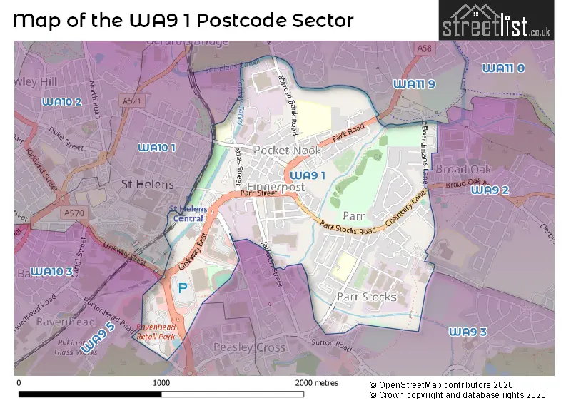
The WA9 1 Postcode shares a border with WA9 3 (ST. HELENS), WA9 5 (ST. HELENS, Thatto Heath, Sherdley Road Industrial Estate), WA10 1 (ST. HELENS), WA11 9 (ST. HELENS, Haydock) and WA9 2 (ST. HELENS).
The sector is within the post town of ST. HELENS.
WA9 1 is a postcode sector within the WA9 postcode district which is within the WA Warrington postcode area.
The Royal Mail delivery office for the WA9 1 postal sector is the St Helens Delivery Office.
The area of the WA9 1 postcode sector is 1.00 square miles which is 2.59 square kilometres or 639.76 square acres.
Waterways within the WA9 1 postcode sector include the St Helens Canal, The Hotties.

Map of the WA9 1 Postcode Sector
Explore the WA9 1 postcode sector by using our free interactive map.
| W | A | 9 | - | 1 | X | X |
| W | A | 9 | Space | 1 | Letter | Letter |
Official List of Streets
ST. HELENS (105 Streets)
Parr Industrial Estate (3 Streets)
Parr (1 Streets)
Unofficial Streets or Alternative Spellings
ST. HELENS
BRIDGEWATER CLOSE BROAD OAK ROAD BURTONHEAD ROAD CHALON WAY EAST CROMDALE GROVE EDWARD STREET EGERTON STREET GOWER STREET ISLANDS BROW PEASLEY CROSS LANE SHAW STREET SOMERSET STREET STANDISH STREET ASHCROFT SERVICE STATION CALDWELL STREET CANNINGTON CHALON WAY DELVES CLOSE DURHAM CLOSE EAST SIDE EVELYN STREET IVY COURT LANGTREE WAY LINKWAY EAST OKEEFFE ROAD PEASLEY CROSS ST HELENS LINKWAY ST HELENS WAY STEVE PRESCOTT BRIDGE SUSSEX GROVE WARRINGTON OLD ROAD WILLIAMSON STREETParr
PARR STOCKS ROADWeather Forecast for WA9 1
Press Button to Show Forecast for St Helens
| Time Period | Icon | Description | Temperature | Rain Probability | Wind |
|---|---|---|---|---|---|
| 21:00 to 00:00 | Cloudy | 6.0°C (feels like 4.0°C) | 48.00% | ENE 7 mph |
Press Button to Show Forecast for St Helens
| Time Period | Icon | Description | Temperature | Rain Probability | Wind |
|---|---|---|---|---|---|
| 00:00 to 03:00 | Cloudy | 5.0°C (feels like 3.0°C) | 5.00% | E 7 mph | |
| 03:00 to 06:00 | Clear night | 3.0°C (feels like 1.0°C) | 1.00% | ENE 4 mph | |
| 06:00 to 09:00 | Sunny day | 3.0°C (feels like 1.0°C) | 1.00% | E 4 mph | |
| 09:00 to 12:00 | Cloudy | 7.0°C (feels like 6.0°C) | 4.00% | E 4 mph | |
| 12:00 to 15:00 | Cloudy | 9.0°C (feels like 8.0°C) | 9.00% | ENE 4 mph | |
| 15:00 to 18:00 | Cloudy | 10.0°C (feels like 9.0°C) | 8.00% | E 4 mph | |
| 18:00 to 21:00 | Cloudy | 9.0°C (feels like 8.0°C) | 6.00% | NE 4 mph | |
| 21:00 to 00:00 | Cloudy | 6.0°C (feels like 4.0°C) | 6.00% | NE 7 mph |
Press Button to Show Forecast for St Helens
| Time Period | Icon | Description | Temperature | Rain Probability | Wind |
|---|---|---|---|---|---|
| 00:00 to 03:00 | Partly cloudy (night) | 5.0°C (feels like 2.0°C) | 5.00% | E 7 mph | |
| 03:00 to 06:00 | Partly cloudy (night) | 3.0°C (feels like 1.0°C) | 4.00% | E 4 mph | |
| 06:00 to 09:00 | Partly cloudy (day) | 4.0°C (feels like 1.0°C) | 4.00% | E 7 mph | |
| 09:00 to 12:00 | Partly cloudy (day) | 8.0°C (feels like 6.0°C) | 5.00% | ESE 7 mph | |
| 12:00 to 15:00 | Overcast | 10.0°C (feels like 9.0°C) | 15.00% | E 7 mph | |
| 15:00 to 18:00 | Overcast | 11.0°C (feels like 9.0°C) | 19.00% | E 9 mph | |
| 18:00 to 21:00 | Cloudy | 10.0°C (feels like 8.0°C) | 14.00% | ENE 9 mph | |
| 21:00 to 00:00 | Cloudy | 7.0°C (feels like 5.0°C) | 15.00% | ENE 9 mph |
Press Button to Show Forecast for St Helens
| Time Period | Icon | Description | Temperature | Rain Probability | Wind |
|---|---|---|---|---|---|
| 00:00 to 03:00 | Overcast | 6.0°C (feels like 3.0°C) | 18.00% | NE 7 mph | |
| 03:00 to 06:00 | Cloudy | 5.0°C (feels like 3.0°C) | 16.00% | NNE 9 mph | |
| 06:00 to 09:00 | Light rain | 6.0°C (feels like 3.0°C) | 49.00% | NNE 9 mph | |
| 09:00 to 12:00 | Heavy rain | 8.0°C (feels like 5.0°C) | 73.00% | NNE 9 mph | |
| 12:00 to 15:00 | Heavy rain | 9.0°C (feels like 6.0°C) | 73.00% | N 11 mph | |
| 15:00 to 18:00 | Heavy rain | 10.0°C (feels like 7.0°C) | 75.00% | N 9 mph | |
| 18:00 to 21:00 | Light rain shower (day) | 10.0°C (feels like 8.0°C) | 36.00% | NNW 9 mph | |
| 21:00 to 00:00 | Partly cloudy (night) | 7.0°C (feels like 5.0°C) | 12.00% | NNW 7 mph |
Schools and Places of Education Within the WA9 1 Postcode Sector
Allanson Street Primary School
Community school
Gaskell Street, Merseyside, Merseyside, WA9 1PL
Head: Mrs Lynsey Dingsdale
Ofsted Rating: Good
Inspection: 2019-03-20 (1863 days ago)
Website: Visit Allanson Street Primary School Website
Phone: 01744678144
Number of Pupils: 454
Lansbury Bridge School
Community special school
Lansbury Avenue, St Helens, Merseyside, WA9 1TB
Head: Mrs Carole Austin
Ofsted Rating: Good
Inspection: 2020-01-22 (1555 days ago)
Website: Visit Lansbury Bridge School Website
Phone: 01744678579
Number of Pupils: 223
Merton Bank Primary School
Community school
Roper Street, St Helens, Merseyside, WA9 1EJ
Head: Mrs Rebecca King
Ofsted Rating: Good
Inspection: 2022-11-04 (538 days ago)
Website: Visit Merton Bank Primary School Website
Phone: 0174422104
Number of Pupils: 219
Mill Green School
Community special school
Lansbury Avenue, St Helens, Merseyside, WA9 1BU
Head: Mr Sean Lenahan
Ofsted Rating: Outstanding
Inspection: 2018-11-01 (2002 days ago)
Website: Visit Mill Green School Website
Phone: 01744678760
Number of Pupils: 116
House Prices in the WA9 1 Postcode Sector
| Type of Property | 2018 Average | 2018 Sales | 2017 Average | 2017 Sales | 2016 Average | 2016 Sales | 2015 Average | 2015 Sales |
|---|---|---|---|---|---|---|---|---|
| Detached | £142,167 | 3 | £169,000 | 2 | £163,000 | 7 | £129,062 | 12 |
| Semi-Detached | £99,300 | 15 | £81,113 | 4 | £88,535 | 14 | £76,349 | 8 |
| Terraced | £64,700 | 33 | £60,604 | 39 | £57,455 | 33 | £50,054 | 28 |
| Flats | £54,600 | 5 | £62,111 | 9 | £49,458 | 6 | £47,464 | 14 |
Important Postcodes WA9 1 in the Postcode Sector
WA9 1AR is the postcode for St. Helens College, Langtree Construction Centre, and St. Helens College, Langtree Construction Centre, Langtree Street
WA9 1BQ is the postcode for Parr Swimming Baths, Ashcroft Street
WA9 1BU is the postcode for Mill Green School, Lansbury Avenue
WA9 1EJ is the postcode for KITCHEN BLOCK, Merton Bank Junior & Infant School, Roper Street, The Bridge Centre, Roper Street, and Merton Bank Junior & Infant School, Roper Street
WA9 1HE is the postcode for Brookfield Support Centre for Older People, Park Road, and St. Helens Metropolitan Borough Council, Park Road Centre, Park Road
WA9 1JR is the postcode for RECEPTION BUILDING, St. Helens Metropolitan Borough Council, Hardshaw Brook Depot, Parr Street, VEHICLE WORKSHOP, St. Helens Metropolitan Borough Council, Hardshaw Brook Depot, Parr Street, GENERAL STORE AND ARCHIVES, St. Helens Metropolitan Borough Council, Hardshaw Brook Depot, Parr Street, Vehicle Workshop, Hardshaw Brook Depot, Parr Stree, and PRINT UNIT WORKSHOP, St. Helens Metropolitan Borough Council, Hardshaw Brook Depot, Parr Street
WA9 1LD is the postcode for Atlas House, 2 Corporation Street, and Children & Young Peoples Services, Atlas House, Corporation Street
WA9 1LN is the postcode for Fingerpost Park Health Centre, Atlas Street
WA9 1NU is the postcode for WORKSHOP, St Helens Community Fire Station, Merseyside Fire and Rescue Service, and St Helens Community Fire Station, Merseyside Fire and Rescue Service
WA9 1NY is the postcode for The Changing Rooms, Parr Stocks Playing Field
WA9 1PL is the postcode for The Thompson Centre, Allanson Street Primary School, Gaskell Street, Allanson Street Primary School, Gaskell Street, and SPORTS & ART BLOCK ALLANSON STREET PRIMARY SCHOOL, Allanson Street Primary School, Gaskell Street
WA9 1QF is the postcode for The Mill Green Centre, Sankey Street
WA9 1SY is the postcode for St. Helens Metropolitan Borough Council, Parr Community Library, Fleet Lane
WA9 1TB is the postcode for Lansbury Bridge School, Lansbury Avenue, Lansbury Bridge School And Sports College, Lansbury Avenue, and EARLY YEARS BLOCK LANSBURY BRIDGE SCHOOL, Lansbury Bridge School, Lansbury Avenue
WA9 1TT is the postcode for MAIN BUILDING TECHNOLOGY CAMPUS, St. Helens College, Pocket Nook Street, Waterside, ACADEMY, St. Helens College, Pocket Nook Street, Waterside, and CSC BUILDING, St. Helens College, Pocket Nook Street, Waterside
WA9 1UB is the postcode for Forster House, Waterside
| The WA9 1 Sector is within these Local Authorities |
|
|---|---|
| The WA9 1 Sector is within these Counties |
|
| The WA9 1 Sector is within these Water Company Areas |
|