The WD19 7 postcode sector is within the county of Hertfordshire.
Did you know? According to the 2021 Census, the WD19 7 postcode sector is home to a bustling 5,989 residents!
Given that each sector allows for 400 unique postcode combinations. Letters C, I, K, M, O and V are not allowed in the last two letters of a postcode. With 164 postcodes already in use, this leaves 236 units available.
The WD19 7 postal code covers the settlement of SOUTH OXHEY .
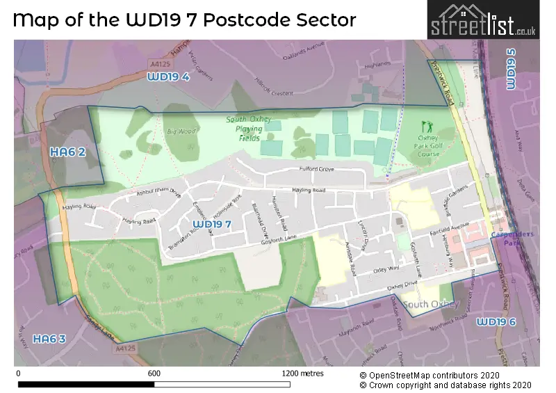
The WD19 7 Postcode shares a border with WD19 4 (WATFORD , OXHEY HALL ), WD19 5 (CARPENDERS PARK ), WD19 6 (SOUTH OXHEY ), HA6 2 (NORTHWOOD , MOOR PARK ) and HA6 3 (NORTHWOOD ).
The sector is within the post town of WATFORD.
WD19 7 is a postcode sector within the WD19 postcode district which is within the WD Watford postcode area.
The Royal Mail delivery office for the WD19 7 postal sector is the Watford (wd) Delivery Office.
The area of the WD19 7 postcode sector is 0.68 square miles which is 1.77 square kilometres or 437.07 square acres.

Map of the WD19 7 Postcode Sector
Explore the WD19 7 postcode sector by using our free interactive map.
| W | D | 1 | 9 | - | 7 | X | X |
| W | D | 1 | 9 | Space | 7 | Letter | Letter |
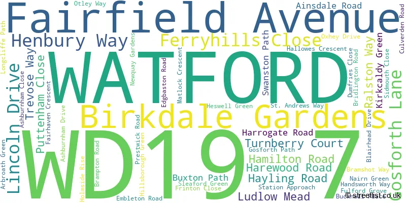
Official List of Streets
WATFORD (52 Streets)
Unofficial Streets or Alternative Spellings
WATFORD
FERNDOWN ROAD GREEN LANE JOHNSTONE CLOSE OAKDALE ROAD SEACROFT GARDENS HUMFRIES CLOSE PADGATE HOUSE PENN HOUSENORTHWOOD,
OXHEY DRIVENORTHWOOD
BATCHWORTH LANE SANDY LANE WESTBURY ROAD WILDACRESWeather Forecast for WD19 7
Press Button to Show Forecast for Northwood
| Time Period | Icon | Description | Temperature | Rain Probability | Wind |
|---|---|---|---|---|---|
| 15:00 to 18:00 | Cloudy | 9.0°C (feels like 6.0°C) | 43.00% | NNW 13 mph | |
| 18:00 to 21:00 | Cloudy | 7.0°C (feels like 4.0°C) | 41.00% | N 11 mph | |
| 21:00 to 00:00 | Partly cloudy (night) | 6.0°C (feels like 2.0°C) | 36.00% | NNW 11 mph |
Press Button to Show Forecast for Northwood
| Time Period | Icon | Description | Temperature | Rain Probability | Wind |
|---|---|---|---|---|---|
| 00:00 to 03:00 | Cloudy | 5.0°C (feels like 1.0°C) | 4.00% | NNW 13 mph | |
| 03:00 to 06:00 | Cloudy | 5.0°C (feels like 1.0°C) | 4.00% | N 11 mph | |
| 06:00 to 09:00 | Sunny day | 4.0°C (feels like 1.0°C) | 0.00% | N 9 mph | |
| 09:00 to 12:00 | Sunny day | 8.0°C (feels like 6.0°C) | 0.00% | N 7 mph | |
| 12:00 to 15:00 | Sunny day | 10.0°C (feels like 10.0°C) | 0.00% | WNW 4 mph | |
| 15:00 to 18:00 | Cloudy | 12.0°C (feels like 10.0°C) | 4.00% | W 9 mph | |
| 18:00 to 21:00 | Cloudy | 11.0°C (feels like 8.0°C) | 7.00% | W 11 mph | |
| 21:00 to 00:00 | Cloudy | 9.0°C (feels like 6.0°C) | 11.00% | WSW 11 mph |
Press Button to Show Forecast for Northwood
| Time Period | Icon | Description | Temperature | Rain Probability | Wind |
|---|---|---|---|---|---|
| 00:00 to 03:00 | Cloudy | 8.0°C (feels like 5.0°C) | 51.00% | WSW 13 mph | |
| 03:00 to 06:00 | Overcast | 9.0°C (feels like 6.0°C) | 10.00% | W 13 mph | |
| 06:00 to 09:00 | Overcast | 9.0°C (feels like 6.0°C) | 47.00% | WNW 11 mph | |
| 09:00 to 12:00 | Light rain | 10.0°C (feels like 7.0°C) | 47.00% | NW 16 mph | |
| 12:00 to 15:00 | Cloudy | 12.0°C (feels like 8.0°C) | 7.00% | NW 16 mph | |
| 15:00 to 18:00 | Cloudy | 12.0°C (feels like 9.0°C) | 9.00% | NNW 13 mph | |
| 18:00 to 21:00 | Cloudy | 11.0°C (feels like 8.0°C) | 5.00% | NNW 11 mph | |
| 21:00 to 00:00 | Cloudy | 8.0°C (feels like 6.0°C) | 8.00% | NE 7 mph |
Press Button to Show Forecast for Northwood
| Time Period | Icon | Description | Temperature | Rain Probability | Wind |
|---|---|---|---|---|---|
| 00:00 to 03:00 | Partly cloudy (night) | 6.0°C (feels like 3.0°C) | 3.00% | N 9 mph | |
| 03:00 to 06:00 | Partly cloudy (night) | 4.0°C (feels like 1.0°C) | 2.00% | NNW 9 mph | |
| 06:00 to 09:00 | Partly cloudy (day) | 4.0°C (feels like 1.0°C) | 2.00% | NNW 9 mph | |
| 09:00 to 12:00 | Cloudy | 7.0°C (feels like 4.0°C) | 4.00% | N 11 mph | |
| 12:00 to 15:00 | Overcast | 9.0°C (feels like 7.0°C) | 8.00% | N 11 mph | |
| 15:00 to 18:00 | Overcast | 10.0°C (feels like 8.0°C) | 8.00% | N 9 mph | |
| 18:00 to 21:00 | Overcast | 9.0°C (feels like 7.0°C) | 8.00% | NNE 9 mph | |
| 21:00 to 00:00 | Partly cloudy (night) | 7.0°C (feels like 5.0°C) | 1.00% | NNE 7 mph |
Press Button to Show Forecast for Northwood
| Time Period | Icon | Description | Temperature | Rain Probability | Wind |
|---|---|---|---|---|---|
| 00:00 to 03:00 | Clear night | 5.0°C (feels like 3.0°C) | 1.00% | N 4 mph | |
| 03:00 to 06:00 | Partly cloudy (night) | 4.0°C (feels like 2.0°C) | 2.00% | N 4 mph | |
| 06:00 to 09:00 | Cloudy | 5.0°C (feels like 2.0°C) | 5.00% | NNW 7 mph | |
| 09:00 to 12:00 | Cloudy | 8.0°C (feels like 5.0°C) | 6.00% | NNE 9 mph | |
| 12:00 to 15:00 | Overcast | 9.0°C (feels like 7.0°C) | 8.00% | NNE 9 mph | |
| 15:00 to 18:00 | Overcast | 11.0°C (feels like 8.0°C) | 10.00% | NNE 9 mph | |
| 18:00 to 21:00 | Cloudy | 10.0°C (feels like 8.0°C) | 6.00% | NNE 9 mph | |
| 21:00 to 00:00 | Partly cloudy (night) | 8.0°C (feels like 5.0°C) | 5.00% | NE 9 mph |
Schools and Places of Education Within the WD19 7 Postcode Sector
Colnbrook School
Community special school
Hayling Road, Watford, Hertfordshire, WD19 7UY
Head: Ms Caroline Aplin
Ofsted Rating: Outstanding
Inspection: 2023-04-20 (363 days ago)
Website: Visit Colnbrook School Website
Phone: 02084281281
Number of Pupils: 113
Oxhey Wood Primary School
Academy converter
Oxhey Drive, Watford, Hertfordshire, WD19 7SL
Head: Mrs Jenny Morley
Ofsted Rating: Good
Inspection: 2022-01-13 (825 days ago)
Website: Visit Oxhey Wood Primary School Website
Phone: 02084284828
Number of Pupils: 367
St Joseph Catholic Primary School
Voluntary aided school
Ainsdale Road, Watford, Hertfordshire, WD19 7DW
Head: Mrs Linda Payne
Ofsted Rating: Outstanding
Inspection: 2023-06-08 (314 days ago)
Website: Visit St Joseph Catholic Primary School Website
Phone: 02084285371
Number of Pupils: 237
Warren Dell Primary School
Academy converter
Gosforth Lane, Watford, Hertfordshire, WD19 7UZ
Head: Mrs Jenny Morley
Ofsted Rating: Good
Inspection: 2022-01-26 (812 days ago)
Website: Visit Warren Dell Primary School Website
Phone: 02084284571
Number of Pupils: 262
House Prices in the WD19 7 Postcode Sector
| Type of Property | 2018 Average | 2018 Sales | 2017 Average | 2017 Sales | 2016 Average | 2016 Sales | 2015 Average | 2015 Sales |
|---|---|---|---|---|---|---|---|---|
| Detached | £0 | 0 | £0 | 0 | £0 | 0 | £0 | 0 |
| Semi-Detached | £376,179 | 14 | £391,144 | 23 | £375,243 | 14 | £316,333 | 9 |
| Terraced | £350,073 | 26 | £368,424 | 25 | £336,313 | 36 | £295,871 | 31 |
| Flats | £302,980 | 70 | £240,835 | 20 | £228,545 | 11 | £182,850 | 14 |
Important Postcodes WD19 7 in the Postcode Sector
WD19 7AX is the postcode for THE CENTRE, The Centre, Gosforth Lane, The Centre, Gosforth Lane, and South Oxhey Leisure Centre, Gosforth Lane, South Oxhey
WD19 7DW is the postcode for St. Joseph's Catholic Primary School, Ainsdale Road, ST JOSEPHS CATHOLIC PRIMARY SCHOOL, AINSDALE ROAD, and ST JOSEPHS CATHOLIC PRIMARY SCHOOL, AINSDALE ROAD, SOUTH OXHEY
WD19 7HR is the postcode for Quantum Care Ltd, Pinewood Lodge, Oxhey Drive
WD19 7SF is the postcode for Oxhey Health Centre, Oxhey Drive
WD19 7SL is the postcode for Oxhey Wood Primary School, Oxhey Drive, and OXHEY WOOD PRIMARY SCHOOL, OXHEY DRIVE, SOUTH OXHEY
WD19 7UY is the postcode for Colnbrook School, Hayling Road
WD19 7UZ is the postcode for Warren Dell Primary School, Gosforth Lane
| The WD19 7 Sector is within these Local Authorities |
|
|---|---|
| The WD19 7 Sector is within these Counties |
|
| The WD19 7 Sector is within these Water Company Areas |
|