The WD25 9 postcode sector is within the county of Hertfordshire.
Did you know? According to the 2021 Census, the WD25 9 postcode sector is home to a bustling 11,294 residents!
Given that each sector allows for 400 unique postcode combinations. Letters C, I, K, M, O and V are not allowed in the last two letters of a postcode. With 212 postcodes already in use, this leaves 188 units available.
The largest settlements in the WD25 9 postal code are WATFORD and GARSTON .
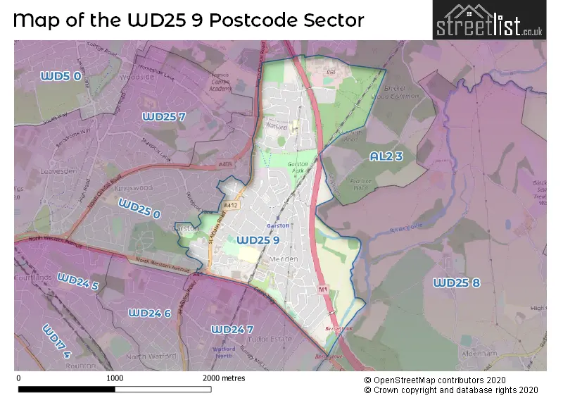
The WD25 9 Postcode shares a border with WD24 7 (WATFORD ), AL2 3 (BRICKET WOOD, CHISWELL GREEN, ST ALBANS), WD25 0 (WATFORD , ABBOTS LANGLEY ) and WD25 8 (ALDENHAM , WATFORD , LETCHMORE HEATH ).
The sector is within the post town of WATFORD.
WD25 9 is a postcode sector within the WD25 postcode district which is within the WD Watford postcode area.
The Royal Mail delivery office for the WD25 9 postal sector is the Watford (wd) Delivery Office.
The area of the WD25 9 postcode sector is 1.26 square miles which is 3.25 square kilometres or 803.68 square acres.
The WD25 9 postcode sector is crossed by the M1 motorway.

Map of the WD25 9 Postcode Sector
Explore the WD25 9 postcode sector by using our free interactive map.
| W | D | 2 | 5 | - | 9 | X | X |
| W | D | 2 | 5 | Space | 9 | Letter | Letter |
Official List of Streets
WATFORD (89 Streets)
Unofficial Streets or Alternative Spellings
WATFORD
GARSTON CRESCENT HORSESHOE LANE LAVINIA AVENUE PURBROCK AVENUE ROTHER CLOSE SHEEPCOT LANE WOODMERE AVENUEColney Heath
NORTH ORBITAL ROADBricket Wood
BARNES WALLIS WAY SCHOOL LANE BEKEN COURT BRAMFIELD BURROCK AVENUE HANFORD COURT KINGSWAY NORTH ORBITAL ROAD LEMON FIELD DRIVE NORTH WESTERN AVENUE COLNE WAY OSPREY CLOSE PHILLIPERS THE DOMEWeather Forecast for WD25 9
Press Button to Show Forecast for Garston
| Time Period | Icon | Description | Temperature | Rain Probability | Wind |
|---|---|---|---|---|---|
| 00:00 to 03:00 | Cloudy | 5.0°C (feels like 3.0°C) | 3.00% | NNW 7 mph | |
| 03:00 to 06:00 | Cloudy | 5.0°C (feels like 2.0°C) | 4.00% | NNW 9 mph | |
| 06:00 to 09:00 | Cloudy | 5.0°C (feels like 2.0°C) | 4.00% | NNW 9 mph | |
| 09:00 to 12:00 | Cloudy | 7.0°C (feels like 4.0°C) | 3.00% | NNW 11 mph | |
| 12:00 to 15:00 | Cloudy | 9.0°C (feels like 7.0°C) | 4.00% | N 11 mph | |
| 15:00 to 18:00 | Cloudy | 10.0°C (feels like 8.0°C) | 4.00% | N 9 mph | |
| 18:00 to 21:00 | Partly cloudy (day) | 9.0°C (feels like 7.0°C) | 1.00% | N 7 mph | |
| 21:00 to 00:00 | Partly cloudy (night) | 6.0°C (feels like 5.0°C) | 1.00% | NE 4 mph |
Press Button to Show Forecast for Garston
| Time Period | Icon | Description | Temperature | Rain Probability | Wind |
|---|---|---|---|---|---|
| 00:00 to 03:00 | Cloudy | 5.0°C (feels like 4.0°C) | 5.00% | S 4 mph | |
| 03:00 to 06:00 | Cloudy | 5.0°C (feels like 3.0°C) | 4.00% | WSW 4 mph | |
| 06:00 to 09:00 | Cloudy | 5.0°C (feels like 3.0°C) | 4.00% | W 7 mph | |
| 09:00 to 12:00 | Partly cloudy (day) | 8.0°C (feels like 6.0°C) | 3.00% | WNW 9 mph | |
| 12:00 to 15:00 | Cloudy | 10.0°C (feels like 8.0°C) | 9.00% | WNW 9 mph | |
| 15:00 to 18:00 | Cloudy | 11.0°C (feels like 9.0°C) | 9.00% | WNW 9 mph | |
| 18:00 to 21:00 | Cloudy | 10.0°C (feels like 9.0°C) | 11.00% | NNW 7 mph | |
| 21:00 to 00:00 | Cloudy | 7.0°C (feels like 6.0°C) | 6.00% | NNE 4 mph |
Press Button to Show Forecast for Garston
| Time Period | Icon | Description | Temperature | Rain Probability | Wind |
|---|---|---|---|---|---|
| 00:00 to 03:00 | Cloudy | 6.0°C (feels like 4.0°C) | 5.00% | ENE 4 mph | |
| 03:00 to 06:00 | Cloudy | 5.0°C (feels like 3.0°C) | 6.00% | ENE 4 mph | |
| 06:00 to 09:00 | Cloudy | 5.0°C (feels like 3.0°C) | 9.00% | E 4 mph | |
| 09:00 to 12:00 | Cloudy | 8.0°C (feels like 6.0°C) | 12.00% | ESE 7 mph | |
| 12:00 to 15:00 | Overcast | 10.0°C (feels like 9.0°C) | 17.00% | SE 7 mph | |
| 15:00 to 18:00 | Cloudy | 11.0°C (feels like 9.0°C) | 17.00% | SE 7 mph | |
| 18:00 to 21:00 | Cloudy | 10.0°C (feels like 8.0°C) | 16.00% | SE 9 mph | |
| 21:00 to 00:00 | Cloudy | 8.0°C (feels like 6.0°C) | 15.00% | ESE 7 mph |
Press Button to Show Forecast for Garston
| Time Period | Icon | Description | Temperature | Rain Probability | Wind |
|---|---|---|---|---|---|
| 00:00 to 03:00 | Cloudy | 7.0°C (feels like 5.0°C) | 16.00% | ESE 7 mph | |
| 03:00 to 06:00 | Cloudy | 7.0°C (feels like 5.0°C) | 16.00% | E 7 mph | |
| 06:00 to 09:00 | Overcast | 7.0°C (feels like 5.0°C) | 20.00% | E 7 mph | |
| 09:00 to 12:00 | Cloudy | 10.0°C (feels like 8.0°C) | 14.00% | SE 7 mph | |
| 12:00 to 15:00 | Cloudy | 12.0°C (feels like 10.0°C) | 12.00% | ESE 9 mph | |
| 15:00 to 18:00 | Cloudy | 12.0°C (feels like 10.0°C) | 36.00% | ESE 9 mph | |
| 18:00 to 21:00 | Cloudy | 12.0°C (feels like 10.0°C) | 19.00% | E 9 mph | |
| 21:00 to 00:00 | Cloudy | 10.0°C (feels like 9.0°C) | 17.00% | E 7 mph |
Schools and Places of Education Within the WD25 9 Postcode Sector
Coates Way JMI and Nursery School
Community school
Coates Way, Watford, Hertfordshire, WD25 9NW
Head: Mrs Fiona Hayes
Ofsted Rating: Good
Inspection: 2019-03-28 (1854 days ago)
Website: Visit Coates Way JMI and Nursery School Website
Phone: 01923670341
Number of Pupils: 230
The Grove Academy
Academy sponsor led
Fourth Avenue, Watford, Hertfordshire, WD25 9RH
Head: Mrs Sarah Hennigan
Ofsted Rating: Requires improvement
Inspection: 2022-11-30 (511 days ago)
Website: Visit The Grove Academy Website
Phone: 01923674463
Number of Pupils: 524
House Prices in the WD25 9 Postcode Sector
| Type of Property | 2018 Average | 2018 Sales | 2017 Average | 2017 Sales | 2016 Average | 2016 Sales | 2015 Average | 2015 Sales |
|---|---|---|---|---|---|---|---|---|
| Detached | £861,200 | 5 | £578,750 | 8 | £626,875 | 4 | £621,125 | 8 |
| Semi-Detached | £470,078 | 32 | £481,175 | 38 | £439,546 | 49 | £385,492 | 54 |
| Terraced | £374,158 | 19 | £396,980 | 24 | £362,350 | 30 | £329,233 | 32 |
| Flats | £260,713 | 63 | £239,185 | 62 | £230,711 | 84 | £207,058 | 79 |
Important Postcodes WD25 9 in the Postcode Sector
WD25 9FG is the postcode for Langley House, 698 St. Albans Road, and Langley House, 698 St Albans Road
WD25 9NW is the postcode for Coates Way Jmi And Nursery School, Coates Way, Coates Way Jmi & Nursery School, Coates Way, and COATES WAY JMI AND NURSERY SCHOOL, COATES WAY, WATFORD
WD25 9RH is the postcode for The Grove Academy, Fourth Avenue
WD25 9UB is the postcode for Meriden Surgery, Harvest End
| The WD25 9 Sector is within these Local Authorities |
|
|---|---|
| The WD25 9 Sector is within these Counties |
|
| The WD25 9 Sector is within these Water Company Areas |
|