The WF15 8 postcode sector is within the county of West Yorkshire.
Did you know? According to the 2021 Census, the WF15 8 postcode sector is home to a bustling 5,196 residents!
Given that each sector allows for 400 unique postcode combinations. Letters C, I, K, M, O and V are not allowed in the last two letters of a postcode. With 129 postcodes already in use, this leaves 271 units available.
The largest settlement in the WF15 8 postal code is LIVERSEDGE followed by Hartshead, and Hightown.
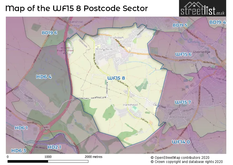
The WF15 8 Postcode shares a border with WF15 6 (LIVERSEDGE, Little Town), WF14 0 (MIRFIELD), WF15 7 (LIVERSEDGE), BD19 5 (CLECKHEATON, Rawfolds, Marsh), BD19 6 (Scholes, CLECKHEATON, Chain Bar) and HD6 4 (BRIGHOUSE, Bailiff Bridge, Clifton).
The sector is within the post town of LIVERSEDGE.
WF15 8 is a postcode sector within the WF15 postcode district which is within the WF Wakefield postcode area.
The Royal Mail delivery office for the WF15 8 postal sector is the Heckmondwike Delivery Office.
The area of the WF15 8 postcode sector is 2.09 square miles which is 5.42 square kilometres or 1,338.86 square acres.
The WF15 8 postcode sector is crossed by the M62 motorway.

Map of the WF15 8 Postcode Sector
Explore the WF15 8 postcode sector by using our free interactive map.
| W | F | 1 | 5 | - | 8 | X | X |
| W | F | 1 | 5 | Space | 8 | Letter | Letter |
Official List of Streets
LIVERSEDGE (67 Streets)
Hightown (4 Streets)
Unofficial Streets or Alternative Spellings
CLECKHEATON,
HIGHTOWN ROAD QUAKER LANE BLAKE LAW LANE COMMONSIDE CROSS HILL LANE FREAKFIELD LANE GREEN LANE HARE PARK MEWS HAREPARK DRIVE HARTSHEAD MOOR SERVICES LITTLETHORPE ROAD PEEP GREEN LANE SCITE HOUSE MEADOWS THE HIGHLANDS WELCOME BREAK HARTSHEAD MOORScholes
HALIFAX ROADBRIGHOUSE,
HIGHMOOR LANECLECKHEATON
ASHBOURNE VIEWWeather Forecast for WF15 8
Press Button to Show Forecast for Roberttown
| Time Period | Icon | Description | Temperature | Rain Probability | Wind |
|---|---|---|---|---|---|
| 18:00 to 21:00 | Overcast | 8.0°C (feels like 4.0°C) | 47.00% | WSW 16 mph | |
| 21:00 to 00:00 | Light rain | 9.0°C (feels like 5.0°C) | 53.00% | W 16 mph |
Press Button to Show Forecast for Roberttown
| Time Period | Icon | Description | Temperature | Rain Probability | Wind |
|---|---|---|---|---|---|
| 00:00 to 03:00 | Cloudy | 9.0°C (feels like 6.0°C) | 15.00% | WNW 13 mph | |
| 03:00 to 06:00 | Cloudy | 8.0°C (feels like 5.0°C) | 8.00% | WNW 13 mph | |
| 06:00 to 09:00 | Cloudy | 7.0°C (feels like 4.0°C) | 4.00% | WNW 13 mph | |
| 09:00 to 12:00 | Cloudy | 9.0°C (feels like 6.0°C) | 7.00% | NW 16 mph | |
| 12:00 to 15:00 | Light rain shower (day) | 9.0°C (feels like 6.0°C) | 36.00% | NNW 13 mph | |
| 15:00 to 18:00 | Cloudy | 10.0°C (feels like 7.0°C) | 7.00% | N 11 mph | |
| 18:00 to 21:00 | Cloudy | 8.0°C (feels like 6.0°C) | 5.00% | NNE 9 mph | |
| 21:00 to 00:00 | Cloudy | 5.0°C (feels like 4.0°C) | 5.00% | N 4 mph |
Press Button to Show Forecast for Roberttown
| Time Period | Icon | Description | Temperature | Rain Probability | Wind |
|---|---|---|---|---|---|
| 00:00 to 03:00 | Partly cloudy (night) | 4.0°C (feels like 2.0°C) | 1.00% | NNW 7 mph | |
| 03:00 to 06:00 | Partly cloudy (night) | 4.0°C (feels like 1.0°C) | 1.00% | NNW 7 mph | |
| 06:00 to 09:00 | Cloudy | 4.0°C (feels like 1.0°C) | 5.00% | NW 7 mph | |
| 09:00 to 12:00 | Cloudy | 7.0°C (feels like 4.0°C) | 7.00% | N 9 mph | |
| 12:00 to 15:00 | Overcast | 9.0°C (feels like 7.0°C) | 9.00% | N 9 mph | |
| 15:00 to 18:00 | Overcast | 10.0°C (feels like 9.0°C) | 9.00% | N 7 mph | |
| 18:00 to 21:00 | Cloudy | 9.0°C (feels like 8.0°C) | 6.00% | N 7 mph | |
| 21:00 to 00:00 | Partly cloudy (night) | 7.0°C (feels like 6.0°C) | 2.00% | N 4 mph |
Press Button to Show Forecast for Roberttown
| Time Period | Icon | Description | Temperature | Rain Probability | Wind |
|---|---|---|---|---|---|
| 00:00 to 03:00 | Cloudy | 6.0°C (feels like 5.0°C) | 4.00% | N 4 mph | |
| 03:00 to 06:00 | Cloudy | 6.0°C (feels like 5.0°C) | 6.00% | WNW 4 mph | |
| 06:00 to 09:00 | Cloudy | 6.0°C (feels like 5.0°C) | 6.00% | NW 2 mph | |
| 09:00 to 12:00 | Overcast | 7.0°C (feels like 6.0°C) | 14.00% | NE 4 mph | |
| 12:00 to 15:00 | Overcast | 9.0°C (feels like 8.0°C) | 11.00% | NE 7 mph | |
| 15:00 to 18:00 | Overcast | 10.0°C (feels like 8.0°C) | 13.00% | NE 7 mph | |
| 18:00 to 21:00 | Overcast | 9.0°C (feels like 7.0°C) | 11.00% | ENE 7 mph | |
| 21:00 to 00:00 | Cloudy | 7.0°C (feels like 6.0°C) | 7.00% | ENE 7 mph |
Press Button to Show Forecast for Roberttown
| Time Period | Icon | Description | Temperature | Rain Probability | Wind |
|---|---|---|---|---|---|
| 00:00 to 03:00 | Cloudy | 6.0°C (feels like 4.0°C) | 7.00% | ENE 4 mph | |
| 03:00 to 06:00 | Overcast | 5.0°C (feels like 4.0°C) | 11.00% | ENE 4 mph | |
| 06:00 to 09:00 | Cloudy | 5.0°C (feels like 4.0°C) | 9.00% | NE 4 mph | |
| 09:00 to 12:00 | Overcast | 7.0°C (feels like 6.0°C) | 11.00% | ENE 7 mph | |
| 12:00 to 15:00 | Cloudy | 9.0°C (feels like 7.0°C) | 10.00% | ENE 7 mph | |
| 15:00 to 18:00 | Cloudy | 10.0°C (feels like 8.0°C) | 10.00% | ENE 7 mph | |
| 18:00 to 21:00 | Cloudy | 9.0°C (feels like 8.0°C) | 12.00% | ENE 7 mph | |
| 21:00 to 00:00 | Cloudy | 7.0°C (feels like 6.0°C) | 9.00% | E 4 mph |
Schools and Places of Education Within the WF15 8 Postcode Sector
Hartshead Junior and Infant School
Community school
School Lane, Liversedge, West Yorkshire, WF15 8AW
Head: Mrs Sarah Shaw
Ofsted Rating: Good
Inspection: 2019-11-19 (1612 days ago)
Website: Visit Hartshead Junior and Infant School Website
Phone: 01274879700
Number of Pupils: 83
High Bank Junior Infant and Nursery School
Community school
Eighth Avenue, Liversedge, West Yorkshire, WF15 8LD
Head: Mrs Kathryn Chubb
Ofsted Rating: Good
Inspection: 2019-10-24 (1638 days ago)
Website: Visit High Bank Junior Infant and Nursery School Website
Phone: 01274875330
Number of Pupils: 133
Hightown Junior Infant & Nursery School
Community school
Hightown Road, Liversedge, West Yorkshire, WF15 8BL
Head: Mr Russell Ingleby
Ofsted Rating: Good
Inspection: 2021-12-02 (868 days ago)
Website: Visit Hightown Junior Infant & Nursery School Website
Phone: 01274865745
Number of Pupils: 214
Roberttown Church of England Voluntary Controlled Junior and Infant School
Voluntary controlled school
Church Road, Liversedge, West Yorkshire, WF15 8BE
Head: Mrs Samantha Laycock-Smith & Mrs Louise Wood
Ofsted Rating: Outstanding
Inspection: 2013-05-02 (4004 days ago)
Website: Visit Roberttown Church of England Voluntary Controlled Junior and Infant School Website
Phone: 01924403532
Number of Pupils: 238
House Prices in the WF15 8 Postcode Sector
| Type of Property | 2018 Average | 2018 Sales | 2017 Average | 2017 Sales | 2016 Average | 2016 Sales | 2015 Average | 2015 Sales |
|---|---|---|---|---|---|---|---|---|
| Detached | £250,250 | 14 | £260,182 | 11 | £254,419 | 13 | £267,211 | 35 |
| Semi-Detached | £141,902 | 21 | £142,626 | 29 | £138,895 | 24 | £120,831 | 24 |
| Terraced | £118,062 | 22 | £125,188 | 8 | £131,789 | 19 | £134,125 | 8 |
| Flats | £77,000 | 2 | £102,000 | 1 | £108,250 | 4 | £0 | 0 |
Important Postcodes WF15 8 in the Postcode Sector
WF15 8AW is the postcode for Hartshead Junior & Infant School, School Lane
WF15 8BE is the postcode for Roberttown Primary School, Church Road, and Roberttown CE J & I School, Church Road
WF15 8BL is the postcode for Hightown School, Hightown Road
WF15 8LD is the postcode for High Bank Junior, Infant and Nursery, Eighth Avenue
| The WF15 8 Sector is within these Local Authorities |
|
|---|---|
| The WF15 8 Sector is within these Counties |
|
| The WF15 8 Sector is within these Water Company Areas |
|